A Crop Classification Method Integrating GF-3 PolSAR and Sentinel-2A Optical Data in the Dongting Lake Basin

 ,
,  ,
,  and
and
Abstract
:1. Introduction
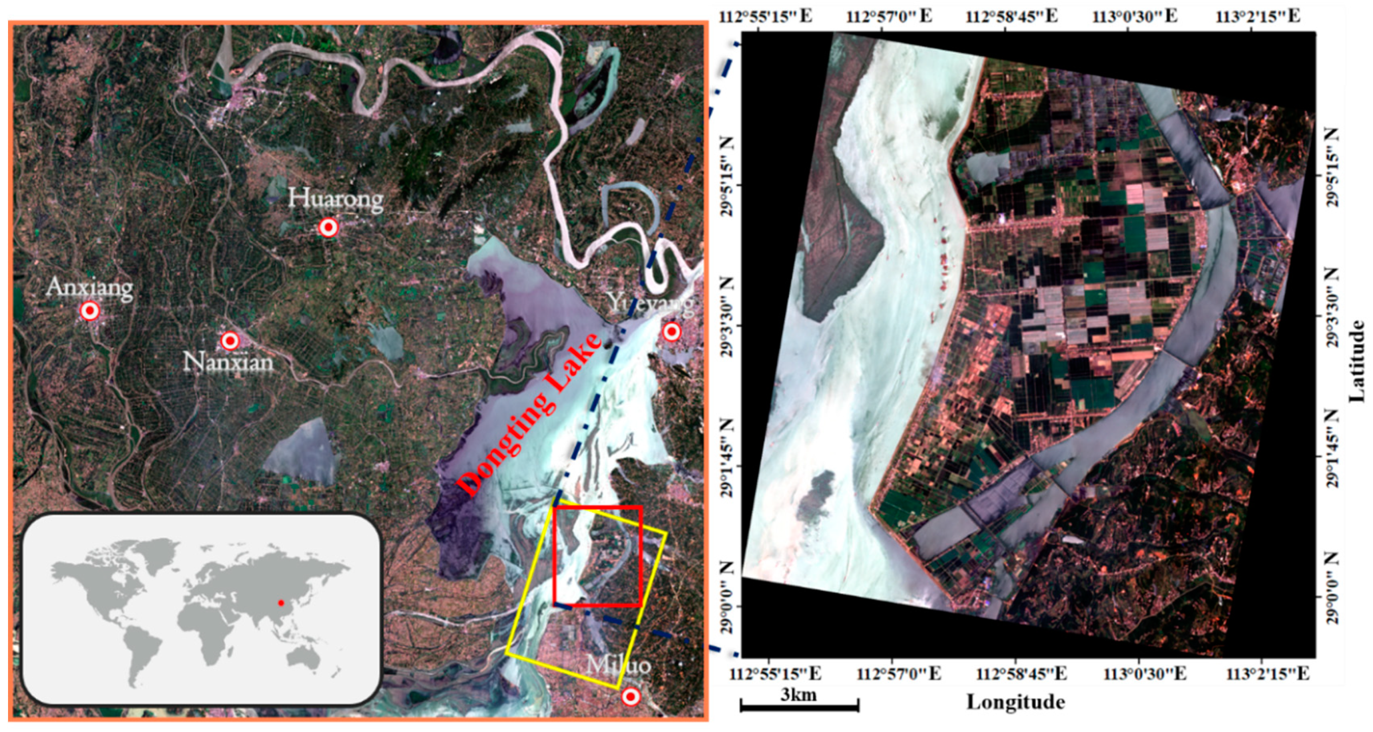
2. Study Area and Dataset
3. Methodology
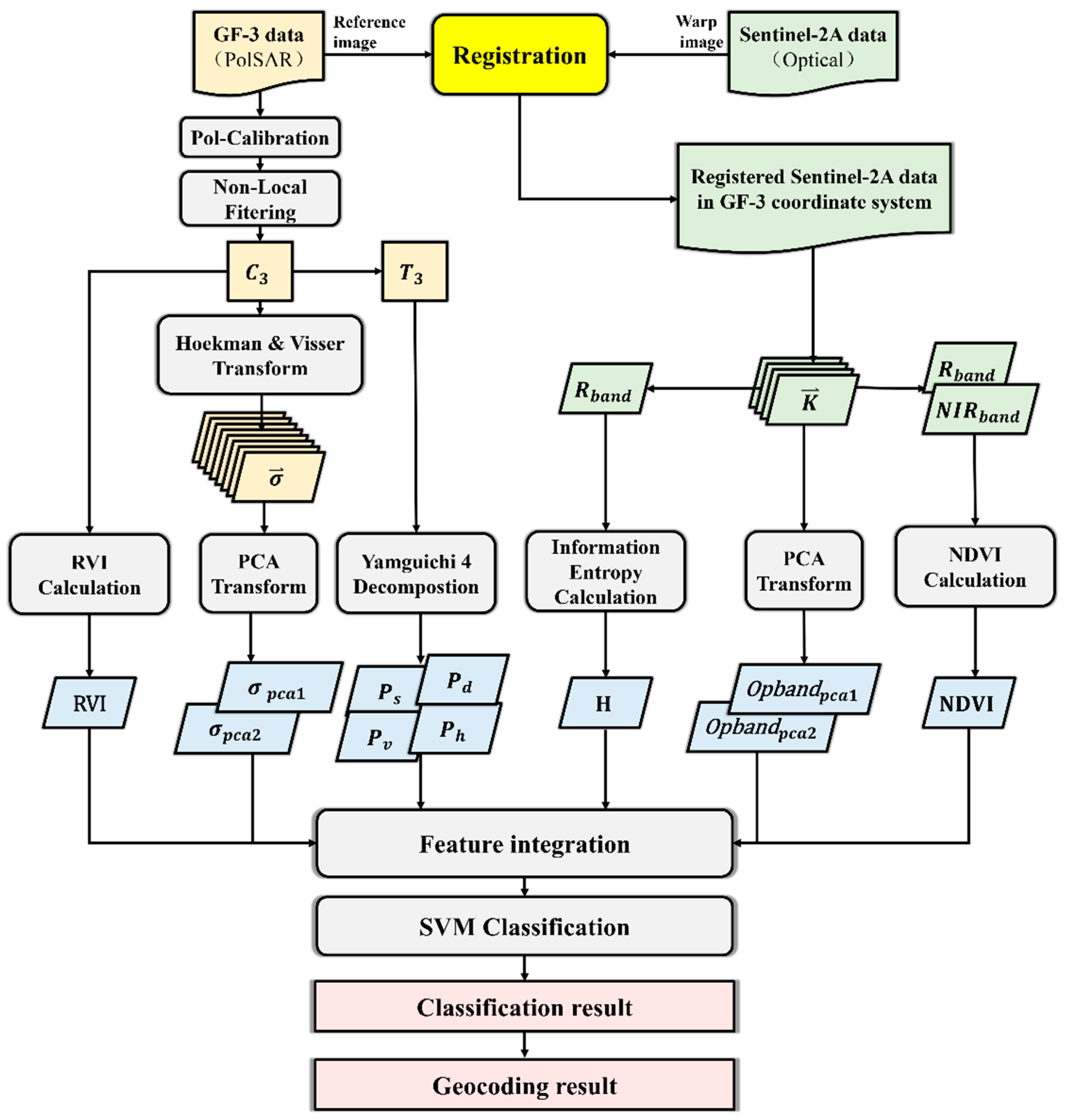
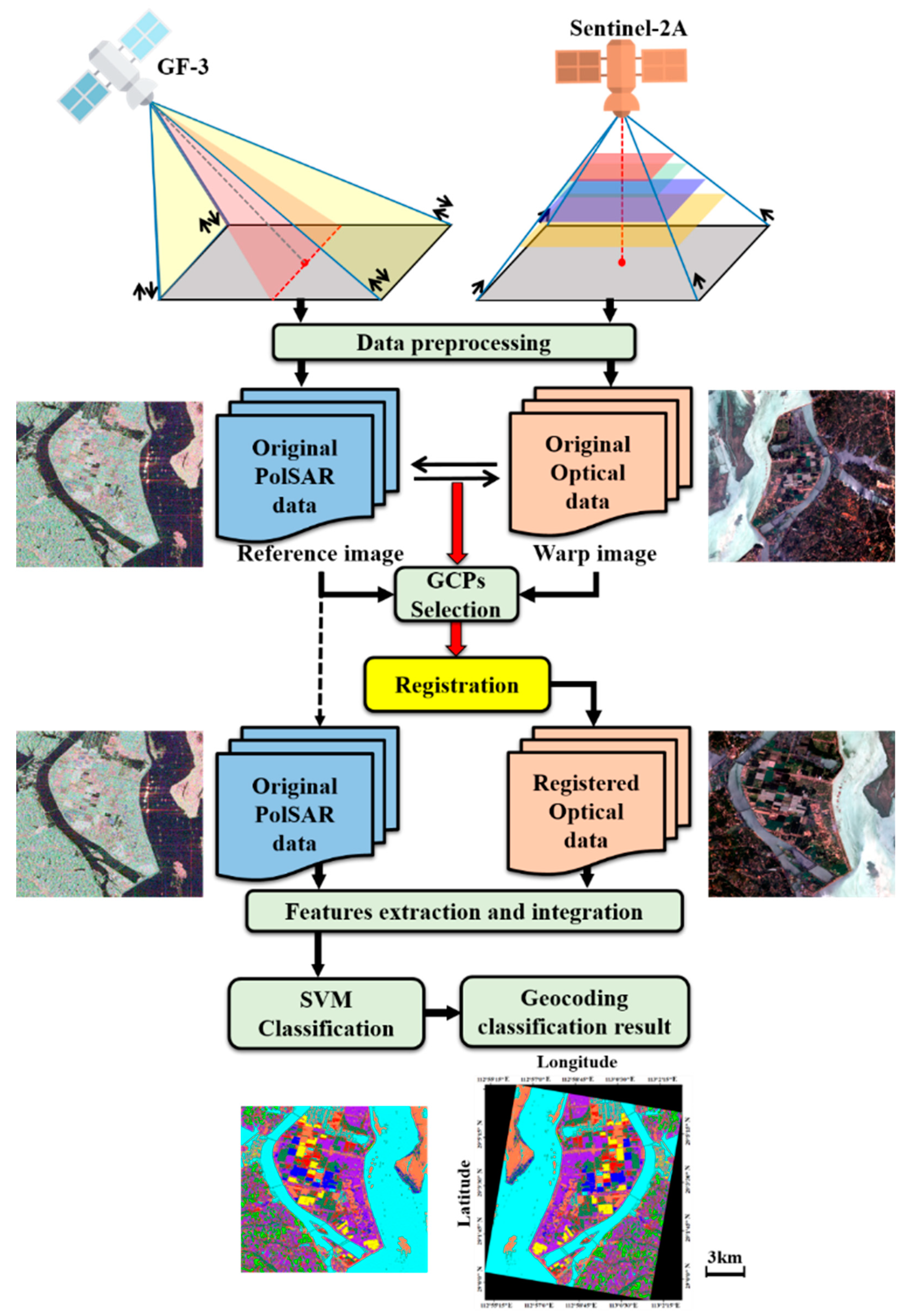
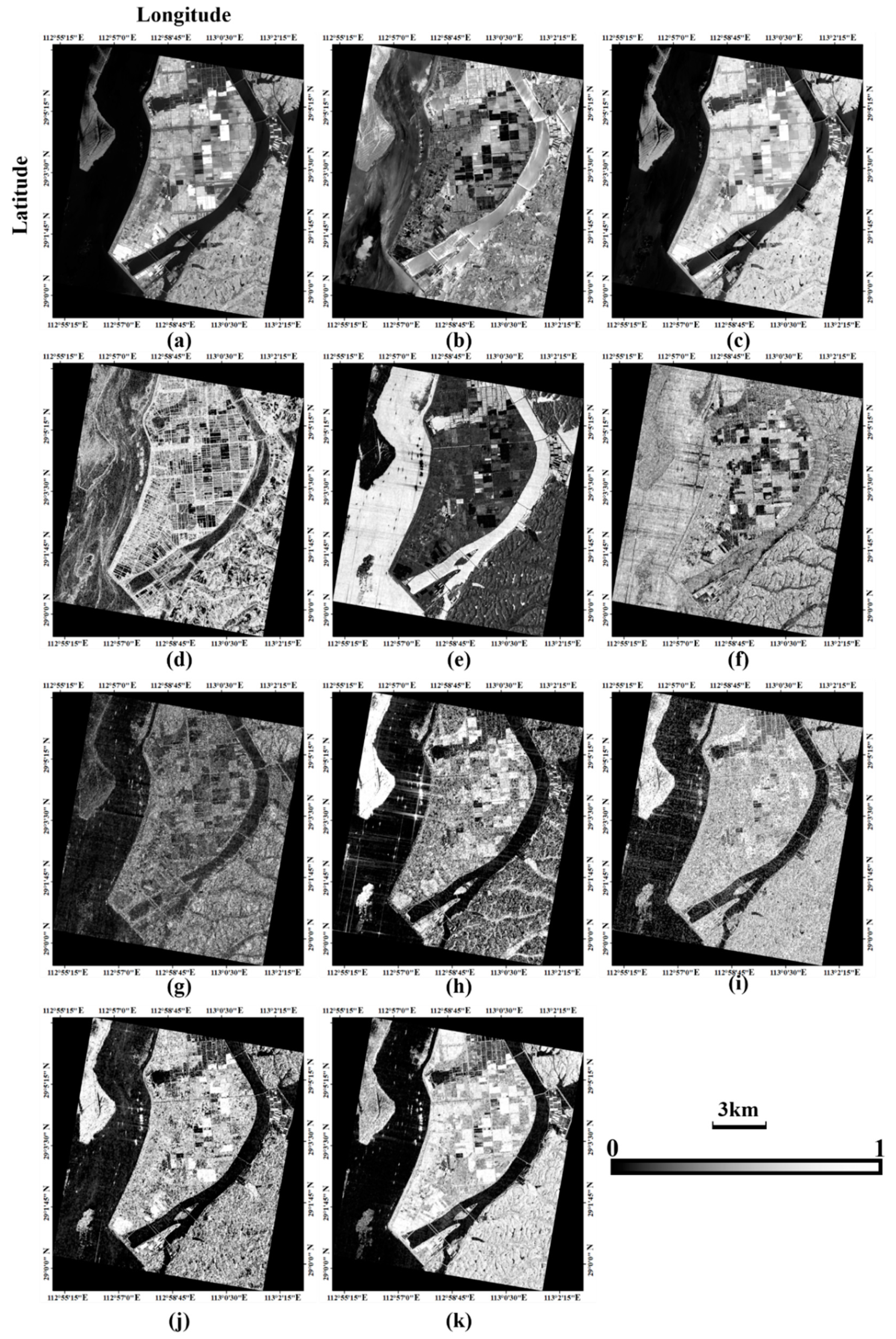
3.1. Data Preprocessing
3.2. Feature Extraction and Integration
3.3. SVM Classification
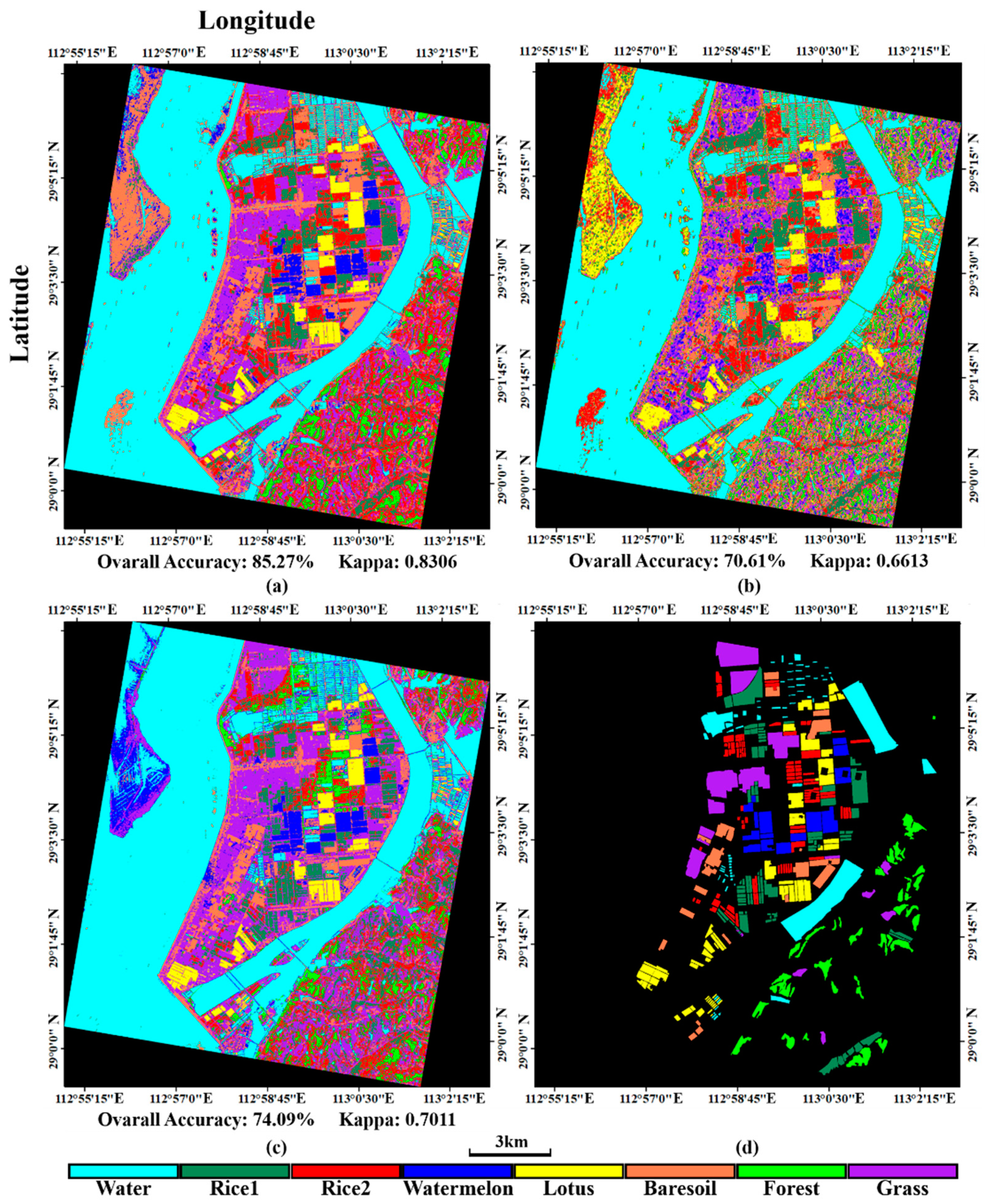
4. Experimental Results
5. Discussion
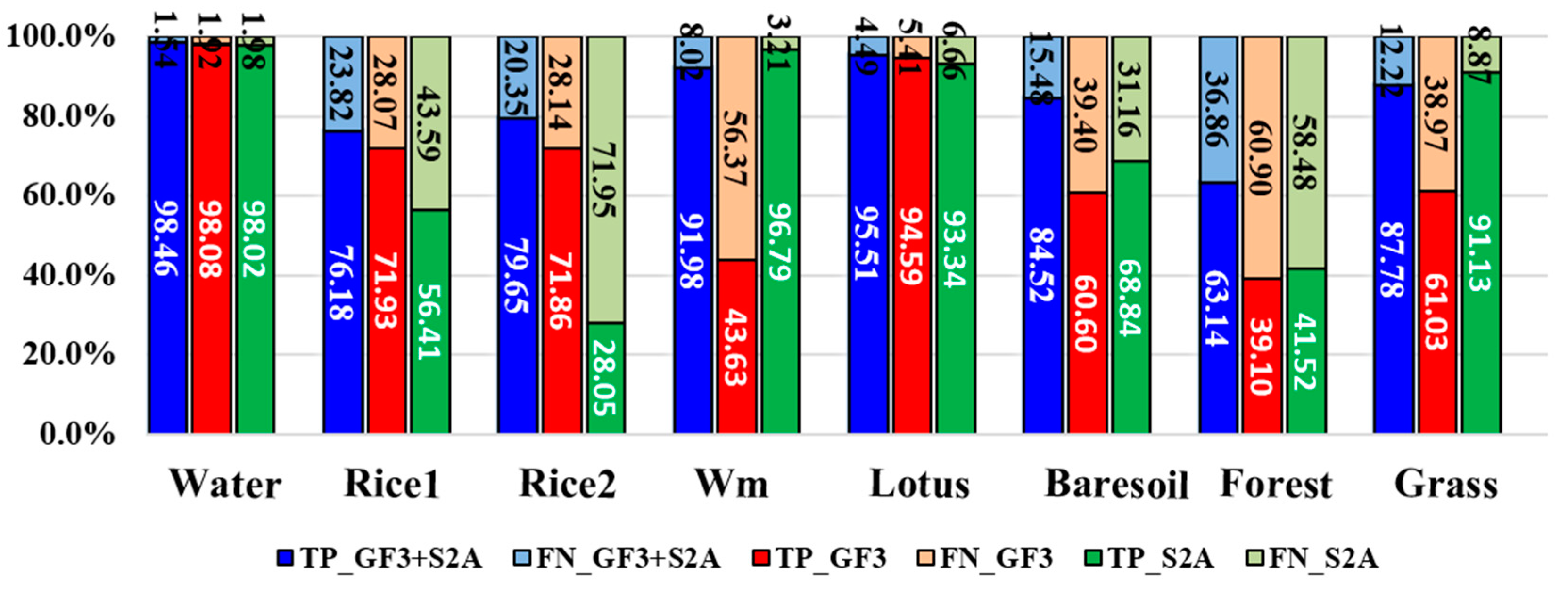
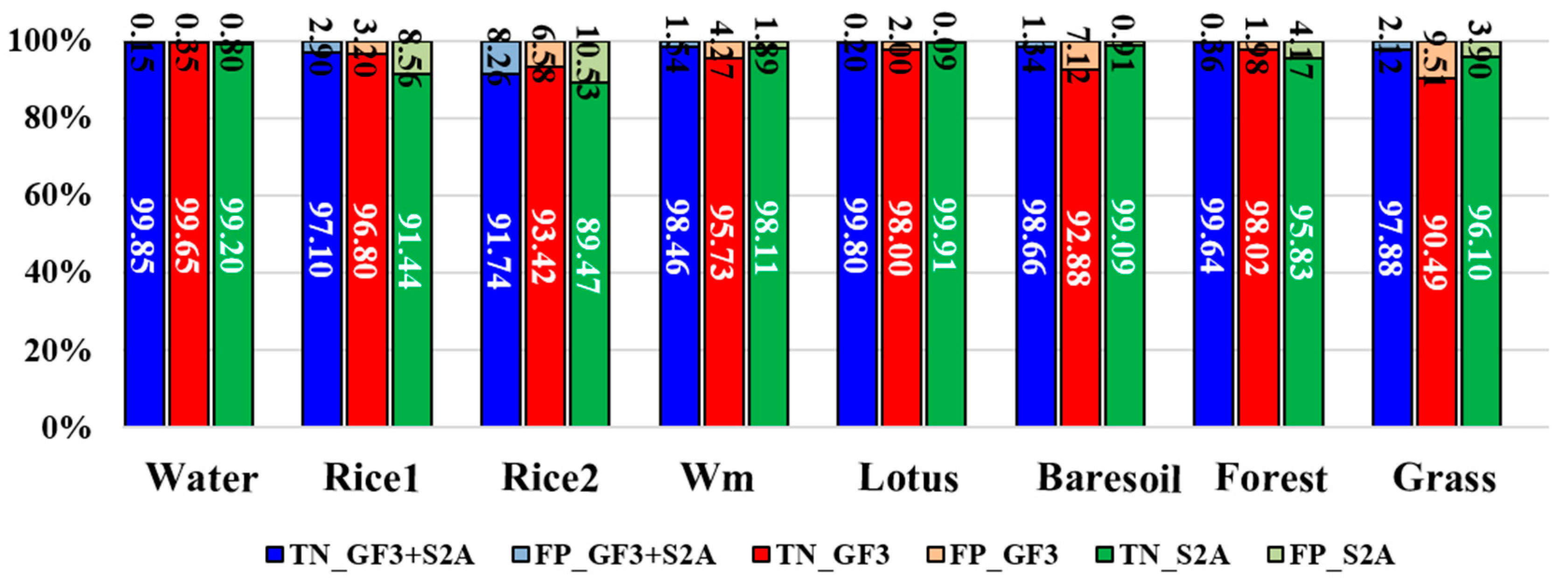
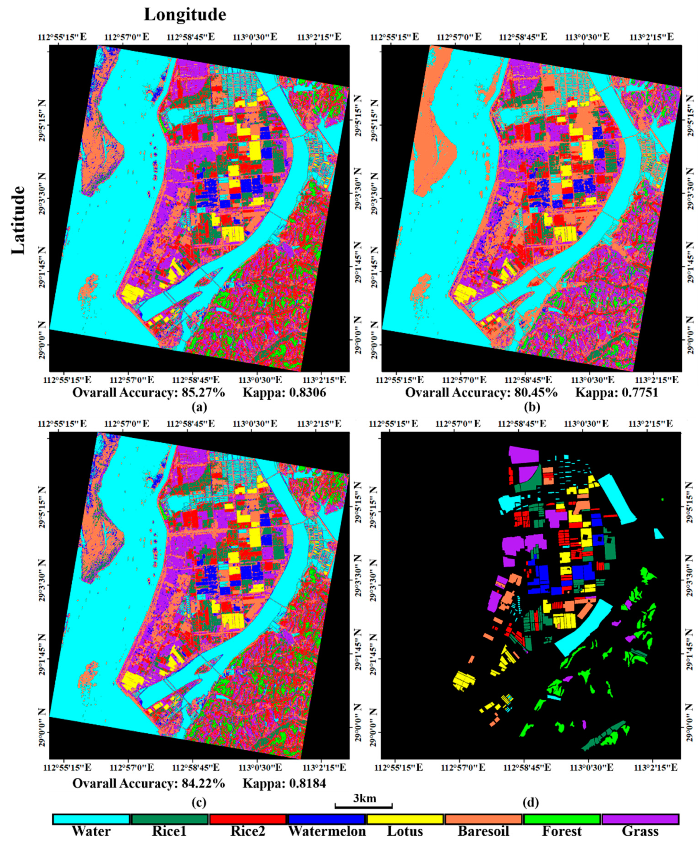
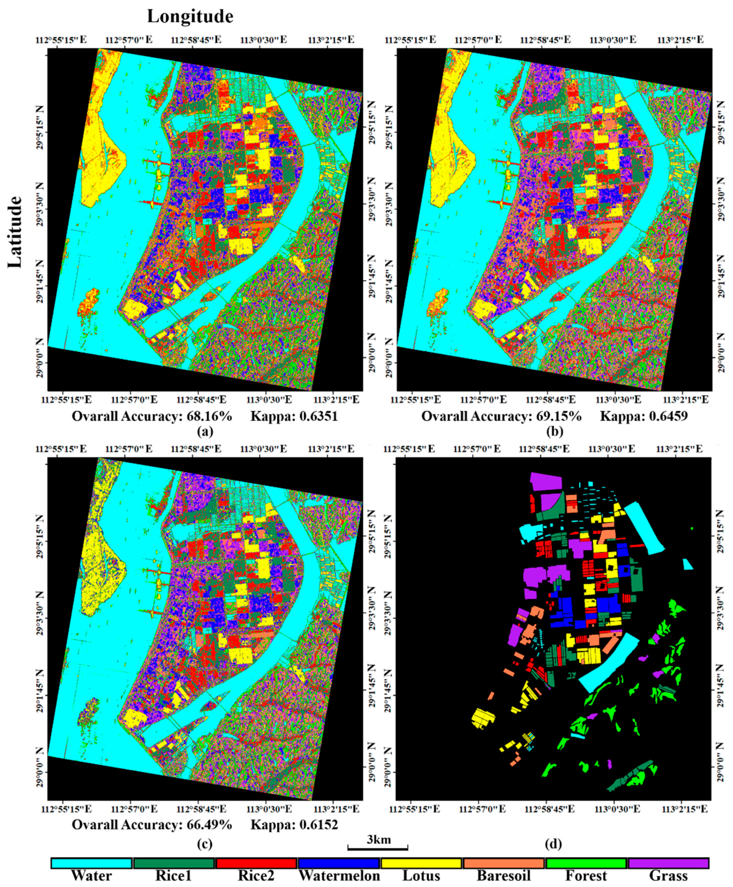
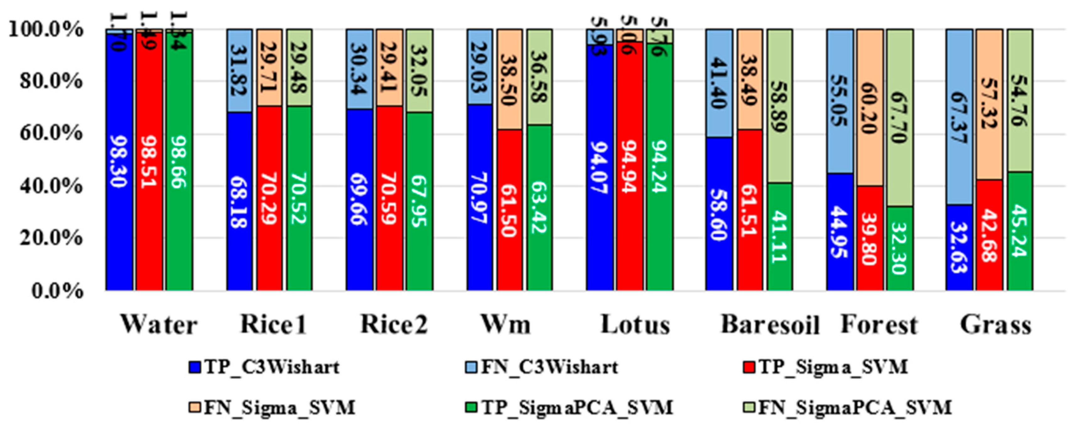
5.1. Comparison with Different Datasets
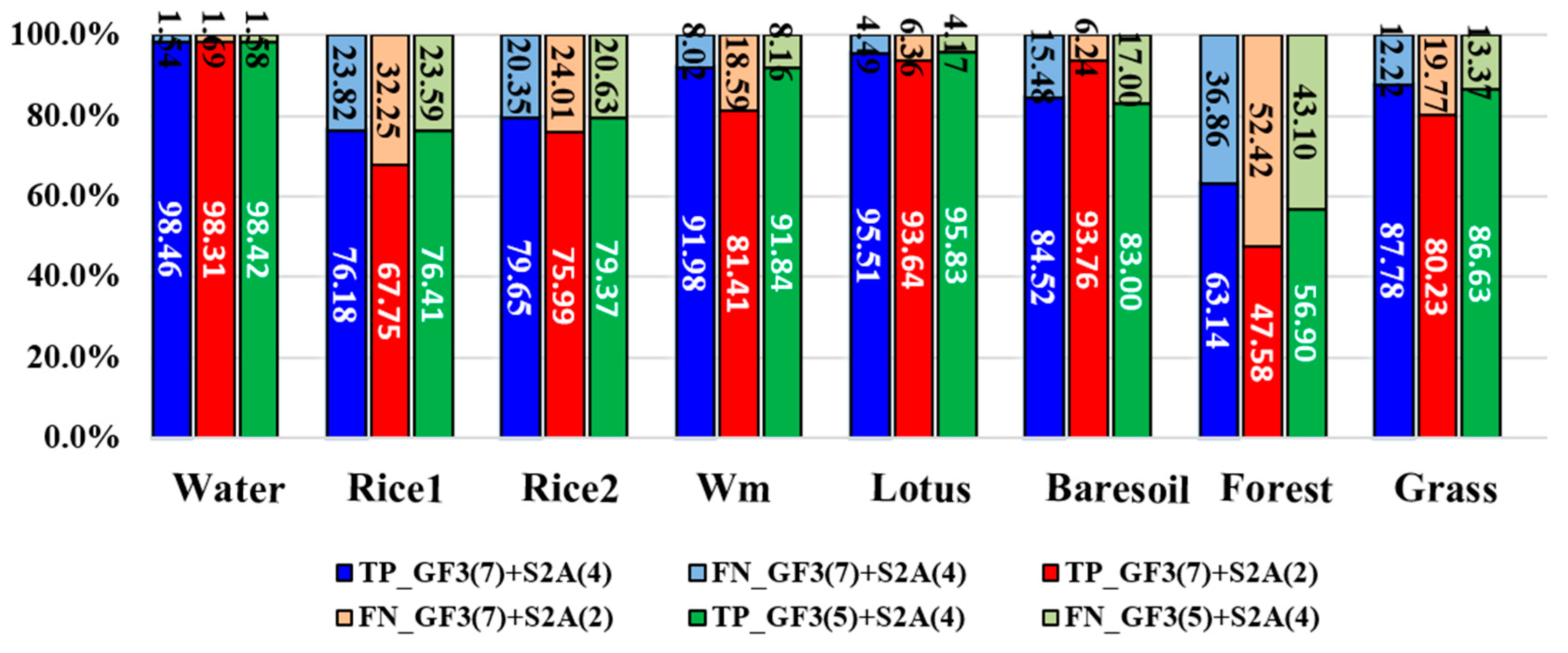
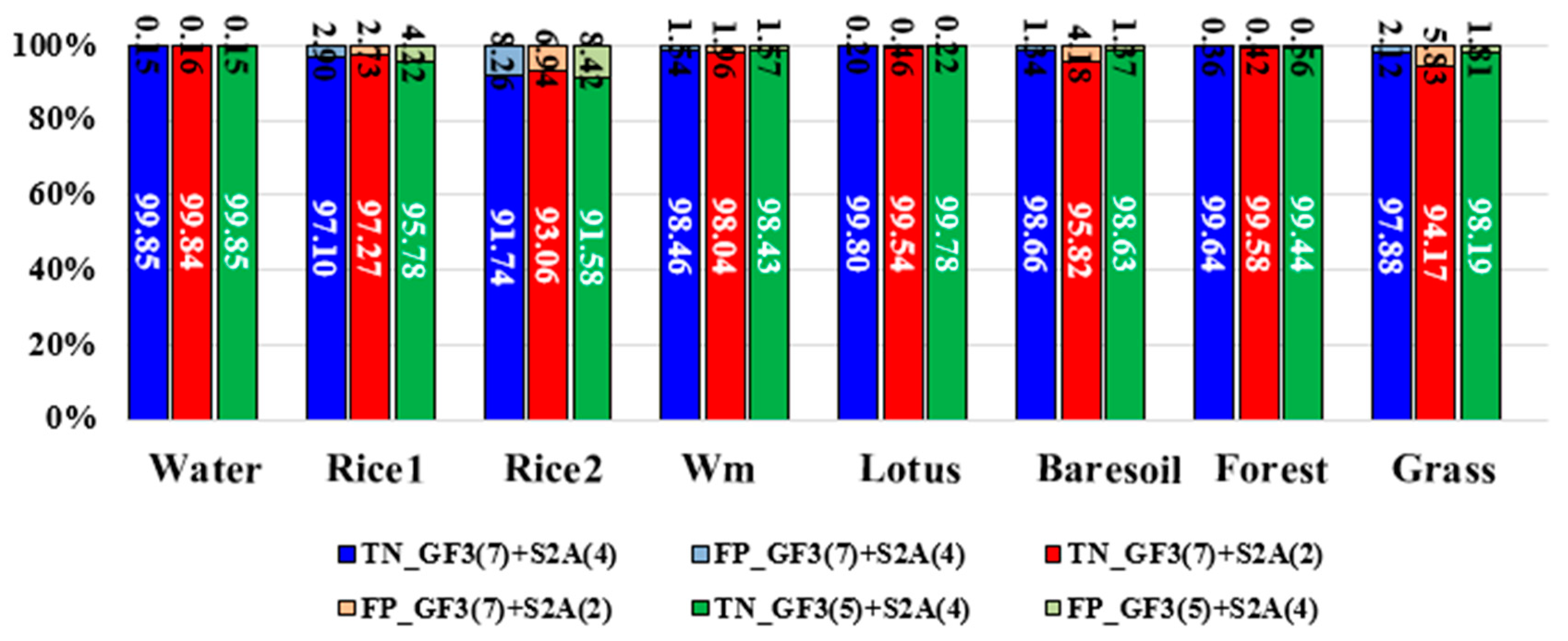
5.2. Comparison with Different Feature Integration Modes
5.3. Classification Ability of
6. Conclusions
Author Contributions
Funding
Acknowledgments
Conflicts of Interest
References
- Hoekman, D.H.; Vissers, M.A.M. A new polarimetric classification approach evaluated for agricultural crops. IEEE Trans. Geosci. Remote Sens. 2003, 41, 2881–2889. [Google Scholar] [CrossRef] [Green Version]
- Haboudane, D.; Tremblay, N.; Miller, J.R.; Vigneault, P. Remote Estimation of Crop Chlorophyll Content Using Spectral Indices Derived From Hyperspectral Data. IEEE Trans. Geosci. Remote Sens. 2008, 46, 423–437. [Google Scholar] [CrossRef]
- Cloutis, E.A.; Connery, D.R.; Major, D.J.; Dover, F.J. Airborne multi-spectral monitoring of agricultural crop status: Effect of time of year, crop type and crop condition parameter. Int. J. Remote Sens. 1996, 17, 2579–2601. [Google Scholar] [CrossRef]
- Steele-Dunne, S.C.; Mcnairn, H.; Monsivais-Huertero, A.; Judge, J.; Liu, P.W.; Papathanassiou, K. Radar Remote Sensing of Agricultural Canopies: A Review. IEEE J. Sel. Top. Appl. Earth Obs. Remote Sens. 2017, 10, 1–25. [Google Scholar] [CrossRef]
- Mcdonald, A.J.; Bennett, J.C.; Cookmartin, G.; Crossley, S.; Morrison, K.; Quegan, S. The effect of leaf geometry on the microwave backscatter from leaves. Int. J. Remote Sens. 2000, 21, 395–400. [Google Scholar] [CrossRef]
- Karam, M.A.; Fung, A.K.; Lang, R.H.; Chauhan, N.S. A Microwave Scattering Model for Layered Vegetation. IEEE Trans. Geosci. Remote Sens. 1992, 30, 767–784. [Google Scholar] [CrossRef]
- ** paddy rice with multitemporal ALOS/PALSAR imagery in southeast China. Int. J. Remote Sens. 2009, 30, 6301–6315. [Google Scholar]
- Skriver, H. Crop Classification by Multitemporal C- and L-Band Single- and Dual-Polarization and Fully Polarimetric SAR. IEEE Trans. Geosci. Remote Sens. 2012, 50, 2138–2149. [Google Scholar] [CrossRef]
- Hoekman, D.H.; Vissers, M.A.M.; Tran, T.N. Unsupervised Full-Polarimetric SAR Data Segmentation as a Tool for Classification of Agricultural Areas. IEEE J. Sel. Top. Appl. Earth Obs. Remote Sens. 2011, 4, 402–411. [Google Scholar] [CrossRef]
- Cloude, S.R.; Pottier, E. An entropy based classification scheme for land applications of polarimetric SAR. IEEE Trans. Geosci. Remote Sens. 1997, 35, 68–78. [Google Scholar] [CrossRef]
- Ainsworth, T.L.; Kelly, J.P.; Lee, J.S. Classification comparisons between dual-pol, compact polarimetric and quad-pol SAR imagery. ISPRS J. Photogramm. Remote Sens. 2009, 64, 464–471. [Google Scholar] [CrossRef]
- Gao, W.; Yang, J.; Ma, W. Land Cover Classification for Polarimetric SAR Images Based on Mixture Models. Remote Sens. 2014, 6, 3770–3790. [Google Scholar] [CrossRef] [Green Version]
- Sonobe, R.; Tani, H.; Wang, X.; Kobayashi, N.; Shimamura, H. Discrimination of crop types with TerraSAR-X-derived information. Phys. Chem. Earth Parts A/B/C 2015, 83–84, 2–13. [Google Scholar] [CrossRef]
- Jiao, X.; Kovacs, J.M.; Shang, J.; Mcnairn, H.; Dan, W.; Ma, B.; Geng, X. Object-oriented crop map** and monitoring using multi-temporal polarimetric RADARSAT-2 data. ISPRS J. Photogramm. Remote Sens. 2014, 96, 38–46. [Google Scholar] [CrossRef]
- Skriver, H.; Mattia, F.; Satalino, G.; Balenzano, A.; Pauwels, V.R.N.; Verhoest, N.E.C.; Davidson, M. Crop Classification Using Short-Revisit Multitemporal SAR Data. IEEE J. Sel. Top. Appl. Earth Obs. Remote Sens. 2011, 4, 423–431. [Google Scholar] [CrossRef]
- Zhou, Y.; Wang, H.; Xu, F.; **, Y.Q. Polarimetric SAR Image Classification Using Deep Convolutional Neural Networks. IEEE Geosci. Remote Sens. Lett. 2017, 13, 1935–1939. [Google Scholar] [CrossRef]
- Cai, Y.; Guan, K.; Peng, J.; Wang, S.; Seifert, C.; Wardlow, B.; Li, Z. A high-performance and in-season classification system of field-level crop types using time-series Landsat data and a machine learning approach. Remote Sens. Environ. 2018, 210, 35–47. [Google Scholar] [CrossRef]
- Massey, R.; Sankey, T.T.; Congalton, R.G.; Yadav, K.; Thenkabail, P.S.; Ozdogan, M.; Sánchez Meador, A.J. MODIS phenology-derived, multi-year distribution of conterminous U.S. crop types. Remote Sens. Environ. 2017, 198, 490–503. [Google Scholar] [CrossRef]
- Gao, F.; Anderson, M.C.; Zhang, X.; Yang, Z.; Alfieri, J.G.; Kustas, W.P.; Mueller, R.; Johnson, D.M.; Prueger, J.H. Toward map** crop progress at field scales through fusion of Landsat and MODIS imagery. Remote Sens. Environ. 2017, 188, 9–25. [Google Scholar] [CrossRef]
- Wardlow, B.D.; Egbert, S.L.; Kastens, J.H. Analysis of time-series MODIS 250 m vegetation index data for crop classification in the U.S. Central Great Plains. Remote Sens. Environ. 2007, 108, 290–310. [Google Scholar] [CrossRef] [Green Version]
- Simonneaux, V.; Duchemin, B.; Helson, D.; Er-Raki, S.; Olioso, A.; Chehbouni, A.G. The use of high-resolution image time series for crop classification and evapotranspiration estimate over an irrigated area in central Morocco. Int. J. Remote Sens. 2008, 29, 95–116. [Google Scholar] [CrossRef] [Green Version]
- Blaes, X.; Vanhalle, L.; Defourny, P. Efficiency of crop identification based on optical and SAR image time series. Remote Sens. Environ. 2005, 96, 352–365. [Google Scholar] [CrossRef]
- Kussul, N.; Skakun, S.; Shelestov, A.; Kravchenko, O.; Kussul, O. Crop Classification in Ukraine Using Satellite Optical and SAR Images. Int. J. Inf. Model Anal. 2013, 2, 118–122. [Google Scholar]
- Haldar, D.; Patnaik, C. Synergistic use of multi-temporal Radarsat SAR and AWiFS data for Rabi rice identification. J. Indian Soc. Remote Sens. 2010, 38, 153–160. [Google Scholar] [CrossRef]
- Dong, J.; ** deciduous rubber plantations through integration of PALSAR and multi-temporal Landsat imagery. Remote Sens. Environ. 2013, 134, 392–402. [Google Scholar]
- Frery, A.C.; Correia, A.H.; Freitas, C.D.C. Classifying Multifrequency Fully Polarimetric Imagery With Multiple Sources of Statistical Evidence and Contextual Information. IEEE Trans. Geosci. Remote Sens. 2007, 45, 3098–3109. [Google Scholar] [CrossRef]
- Waske, B.; Benediktsson, J.A. Fusion of Support Vector Machines for Classification of Multisensor Data. IEEE Trans. Geosci. Remote Sens. 2007, 45, 3858–3866. [Google Scholar] [CrossRef]
- Simone, G.; Farina, A.; Morabito, F.C.; Serpico, S.B.; Bruzzone, L. Image fusion techniques for remote sensing applications. Inf. Fusion 2002, 3, 3–15. [Google Scholar] [CrossRef] [Green Version]
- Chen, Y.; Lin, Z.; Zhao, X.; Wang, G.; Gu, Y. Deep Learning-Based Classification of Hyperspectral Data. IEEE J. Sel. Top. Appl. Earth Obs. Remote Sens. 2017, 7, 2094–2107. [Google Scholar] [CrossRef]
- Zhang, Q. System Design and Key Technologies of the GF-3 Satellite. Acta Geod. Cartogr. Sin. 2017. [Google Scholar] [CrossRef]
- Congalton, R.G. A review of assessing the accuracy of classifications of remotely sensed data. Remote Sens. Environ. 1991, 37, 35–46. [Google Scholar] [CrossRef]
- Congalton, R.G.; Green, K. Assessing the Accuracy of Remotely Sensed Data: Principles and Practices; CRC Press: Boca Raton, FL, USA, 2008. [Google Scholar]
- Deledalle, C.A.; Tupin, F.; Denis, L. Polarimetric SAR estimation based on non-local means. In Proceedings of the Geoscience and Remote Sensing Symposium, Honolulu, HI, USA, 25–30 July 2010; pp. 2515–2518. [Google Scholar]
- Shen, P.; Wang, C.; Gao, H.; Zhu, J. An Adaptive Nonlocal Mean Filter for PolSAR Data with Shape-Adaptive Patches Matching. Sensors 2018, 18, 2215. [Google Scholar] [CrossRef] [PubMed]
- Yamaguchi, Y.; Moriyama, T.; Ishido, M.; Yamada, H. Four-component scattering model for polarimetric SAR image decomposition. IEEE Trans. Geosci. Remote Sens. 2005, 104, 1699–1706. [Google Scholar] [CrossRef]
- Kim, Y.; Zyl, J.J.V. A Time-Series Approach to Estimate Soil Moisture Using Polarimetric Radar Data. IEEE Trans. Geosci. Remote Sens. 2009, 47, 2519–2527. [Google Scholar]
- Li, Z.; Huang, P. Quantitative measures for spatial information of maps. Int. J. Geogr. Inf. Syst. 2002, 16, 699–709. [Google Scholar] [CrossRef]
- Fawcett, T. An introduction to ROC analysis. Pattern Recognit. Lett. 2006, 27, 861–874. [Google Scholar] [CrossRef]


| Item | Parameter |
|---|---|
| Polarization mode | HH, HV, VH and VV |
| Chirp Bandwidth (MHz) | 40 |
| Centre frequency (GHz) | 5.400012 |
| Band | C-band |
| Range pixel spacing (m) | 2.248443 |
| Azimuth pixel spacing (m) | 4.733369 |
| Acquisition Type | Stripmap (QPSI) |
| Start time | 2017-07-19, 22:26:57.615189 |
| Stop time | 2017-07-19, 22:27:01.799853 |
| Incidence angle | 38.16° |
| Item | Parameter |
|---|---|
| Swath (km) | 290 |
| Acquisition time | 2017-07-17, 11:05:41.26 |
| Spectral bands | R (Band 4), G (Band 3), B (Band 2), NIR (Band 8) |
| Centre Wavelength (nm) | R (665), G (560), B (490), NIR (842) |
| Bandwidth (nm) | R (30), G (35), B (65), NIR (115) |
| Spatial Resolution (m) | R (10), G (10), B (10), NIR ( 0) |
| Reference Radiances Lref (W m−2 sr−1 µm−1) | R (108), G (128), B (128), NIR (103) |
| Signal-to-Noise Ratios @ Lref | R (142), G (168), B (154), NIR (174) |
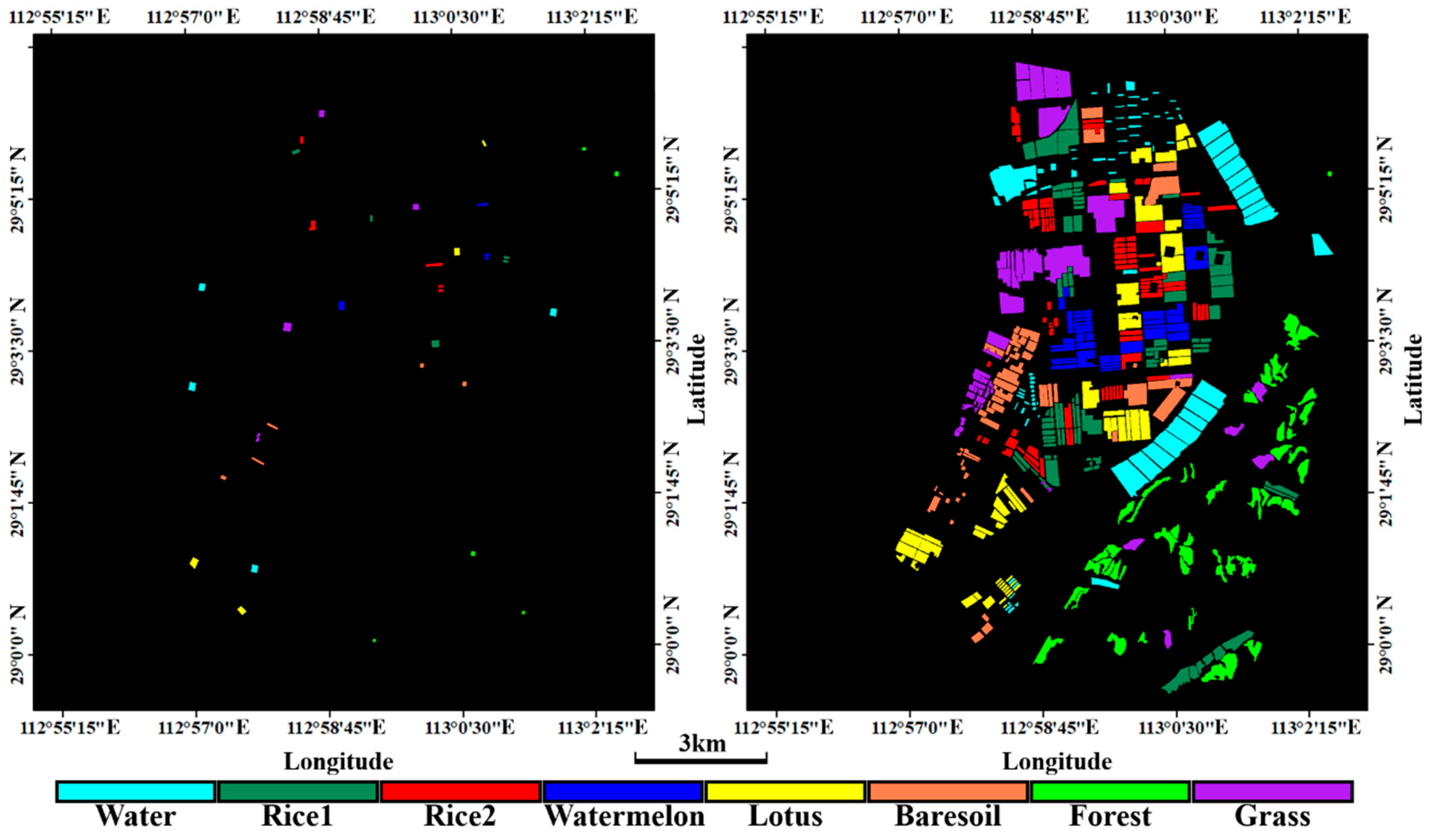
| Land Cover | Training Samples | Testing Samples | ||
|---|---|---|---|---|
| Number of Pixels | Number of Plots | Number of Pixels | Number of Plots | |
| Water | 5118 | 4 | 241,174 | 86 |
| Rice (single-season) | 3305 | 5 | 199,891 | 81 |
| Rice (two-season) | 3572 | 5 | 122,269 | 91 |
| Watermelon | 2679 | 4 | 106,678 | 52 |
| Lotus | 4193 | 4 | 188,068 | 56 |
| Bare soil | 2841 | 5 | 134,727 | 55 |
| Forest | 1890 | 5 | 168,832 | 52 |
| Grass | 4336 | 4 | 208,945 | 54 |
| Pixels | Water | Rice1 | Rice2 | Wm | Lotus | Bare Soil | Forest | Grass | UA (%) |
|---|---|---|---|---|---|---|---|---|---|
| Water | 237,449 | 0 | 0 | 0 | 35 | 1052 | 249 | 377 | 99.28 |
| Rice1 | 5 | 152,273 | 21,550 | 9 | 3014 | 882 | 6381 | 1965 | 81.83 |
| Rice2 | 124 | 44,750 | 97,382 | 13 | 392 | 1108 | 41935 | 13133 | 48.98 |
| Wm | 624 | 34 | 3 | 98,113 | 68 | 13364 | 361 | 3812 | 84.30 |
| Lotus | 0 | 104 | 13 | 0 | 179,632 | 0 | 270 | 1790 | 98.80 |
| Bare soil | 2732 | 591 | 98 | 8074 | 92 | 113,877 | 384 | 3540 | 88.01 |
| Forest | 125 | 342 | 2715 | 0 | 50 | 81 | 106,606 | 910 | 96.19 |
| Grass | 115 | 1797 | 508 | 463 | 4785 | 4363 | 12642 | 183,418 | 88.14 |
| PA (%) | 98.46 | 76.18 | 79.65 | 91.98 | 95.51 | 84.52 | 63.14 | 87.78 | |
| Overall Accuracy (%) | 85.2745 | Kappa coefficient | 0.8306 | ||||||
| Feature Integration Mode | GF-3 Features | Sentinel-2A Features |
|---|---|---|
| GF-3 (7 bands) + S2A (4 bands) | pca1, pca2, RVI, Ps, Pd, Ph and Pv. | Opbandpca1, Opbandpca2, NDVI and H |
| GF-3 (7 bands) + S2A (2 bands) | pca1, pca2, RVI, Ps, Pd, Ph and Pv. | NDVI and H |
| GF-3 (5 bands) + S2A (4 bands) | RVI, Ps, Pd, Ph and Pv. | Opbandpca1, Opbandpca2, NDVI and H |
© 2018 by the authors. Licensee MDPI, Basel, Switzerland. This article is an open access article distributed under the terms and conditions of the Creative Commons Attribution (CC BY) license (http://creativecommons.org/licenses/by/4.0/).
Share and Cite
Gao, H.; Wang, C.; Wang, G.; Zhu, J.; Tang, Y.; Shen, P.; Zhu, Z. A Crop Classification Method Integrating GF-3 PolSAR and Sentinel-2A Optical Data in the Dongting Lake Basin. Sensors 2018, 18, 3139. https://doi.org/10.3390/s18093139
Gao H, Wang C, Wang G, Zhu J, Tang Y, Shen P, Zhu Z. A Crop Classification Method Integrating GF-3 PolSAR and Sentinel-2A Optical Data in the Dongting Lake Basin. Sensors. 2018; 18(9):3139. https://doi.org/10.3390/s18093139
Chicago/Turabian StyleGao, Han, Changcheng Wang, Guanya Wang, Jianjun Zhu, Yuqi Tang, Peng Shen, and Ziwei Zhu. 2018. "A Crop Classification Method Integrating GF-3 PolSAR and Sentinel-2A Optical Data in the Dongting Lake Basin" Sensors 18, no. 9: 3139. https://doi.org/10.3390/s18093139