Article

GPS-Derived Fault Coupling of the Longmenshan Fault Associated with the 2008 Mw Wenchuan 7.9 Earthquake and Its Tectonic Implications

1
State Key Laboratory of Earthquake Dynamics, Institute of Geology, China Earthquake Administration, Bei**g 100029, China
2
First Crust Deformation Monitoring and Application Center, China Earthquake Administration, Tian** 300180, China
*
Author to whom correspondence should be addressed.
Remote Sens. 2018, 10(5), 753; https://doi.org/10.3390/rs10050753
Submission received: 9 March 2018 / Revised: 12 May 2018 / Accepted: 12 May 2018 / Published: 15 May 2018

Abstract

:
Investigating relationships between temporally- and spatially-related continental earthquakes is important for a better understanding of the crustal deformation, the mechanism of earthquake nucleation and occurrence, and the triggering effect between earthquakes. Here we utilize Global Positioning System (GPS) velocities before and after the 2008 Mw 7.9 Wenchuan earthquake to invert the fault coupling of the Longmenshan Fault (LMSF) and investigate the impact of the 2008 Mw 7.9 Wenchuan earthquake on the 2013 Mw 6.6 Lushan earthquake. The results indicate that, before the 2008 Mw 7.9 Wenchuan earthquake, fault segments were strongly coupled and locked at a depth of ~18 km along the central and northern LMSF. The seismic gap between the two earthquake rupture zones was only locked at a depth < 5 km. The southern LMSF was coupled at a depth of ~10 km. However, regions around the hypocenter of the 2013 Mw 6.6 Lushan earthquake were not coupled, with an average coupling coefficient ~0.3. After the 2008 Mw 7.9 Wenchuan earthquake, the central and northern LMSF, including part of the seismic gap, were decoupled, with an average coupling coefficient smaller than 0.2. The southern LMSF, however, was coupled to ~20 km depth. Regions around the hypocenter of the 2013 Mw 6.6 Lushan earthquake were also coupled. Moreover, by interpreting changes of the GPS velocities before and after the 2008 Mw 7.9 Wenchuan earthquake, we find that the upper crust of the eastern Tibet (i.e., the Bayan Har block), which was driven by the postseismic relaxation of the 2008 Mw 7.9 Wenchuan earthquake, thrust at an accelerating pace to the Sichuan block and result in enhanced compression and shear stress on the LMSF. Consequently, downdip coupling of the fault, together with the rapid accumulation of the elastic strain, lead to the occurrence of the 2013 Mw 6.6 Lushan earthquake. Finally, the quantity analysis on the seismic moment accumulated and released along the southern LMSF show that the 2013 Mw 6.6 Lushan earthquake should be defined as a “delayed” aftershock of the 2008 Mw 7.9 Wenchuan earthquake. The seismic risk is low along the seismic gap, but high on the unruptured southwesternmost area of the 2013 Mw 6.6 Lushan earthquake.

Graphical Abstract

1. Introduction

The Longmenshan Fault (LMSF) zone, known as a major thrusting boundary structure, is located at the eastern margin of the Tibetan Plateau, which separates the plateau and the stable South China block [1,2] (Figure 1). The LMSF zone bears particular significance for understanding the uplifting mechanism of the Tibetan Plateau, since it is closely related to the formation of the Longmenshan Mountains, which is controlled by the eastern extrusion of the Tibetan Plateau (e.g., [3,4]). In addition, the LMSF zone controls the crustal deformation and seismicity at the Longmenshan region [5,6,7]. Commonly, intercontinental active tectonic faults are characterized by depth-dependent crustal behaviors, with repeated earthquake ruptures and interseismic coupling in the upper/middle crust, and quasi-stable aseismic creep in the deeper substrate [8]. Thus, investigating the fault coupling of the LMSF and its variation along depth is of great significance for understanding the seismic activities and crustal deformation of the Eastern Tibetan Plateau.
On 12 May 2008, the devastating Mw 7.9 Wenchuan earthquake ruptured the LMSF and generated a 240-km-long surface rupture along the Beichuan Fault and a 72-km-long surface rupture along the Pengguan Fault [2]. The earthquake propagated unilaterally to the northeast, leaving the southern segments of the LMSF (hereafter refered to as the southern LMSF) unbroken [9,10] (Figure 1). In addition, the southern LMSF accommodated few aftershocks [11]. On 20 April 2013, the Mw 6.6 Lushan earthquake ruptured the southern LMSF and filled part of the rupture deficit along the southern LMSF [12]. However, an approximately 60-km-long segment between the rupture zones of the two earthquakes remain unruptured, forming an apparent “seismic gap” [13] (Figure 1). It remains debated that the seismic risk of the 60-km-long seismic gap. Chen et al. [12] and Liu et al. [14,15] suggested that the likelihood of future earthquakes is very high due to the co-seismic coulomb stress loading from the 2008 Mw 7.9 Wenchuan and 2013 Mw 6.6 Lushan earthquakes. Li et al. [16] and Dong et al. [13], in contrast, claimed that the seismic gap is not particularly stressed-up and, thus, the risk for future earthquakes is not especially high. In addition, the 2008 Mw 7.9 Wenchuan and the 2013 Mw 6.6 Lushan events are close, spatially, and have a short time interval of only five years. Thus, a large number of studies have focused on their relationship and have obtained discrepant results (e.g., [12,14,17,18,19]). For instance, there are debates about whether the 2013 Mw 6.6 Lushan earthquake was an aftershock of the 2008 Mw 7.9 Wenchuan earthquake (e.g., [12,14,17,19,20]). Moreover, previous studies indicated that both the co-seismic rupture and postseismic relaxation due to the 2008 event may have increased the stress level on the southern LMSF, which triggered the 2013 event (e.g., [14,18,21]). However, such studies have not considered the interseismic fault coupling characteristics [22].
In view of the aforementioned issues and debates, we use the horizontal GPS velocities to invert the fault coupling of the LMSF before and after the 2008 Mw 7.9 Wenchuan earthquake. We first introduce the GPS data, its processing strategies, and our modeling strategies. Then the inversion results of the fault coupling of the LMSF are analyzed, in attempting to investigate the possible impact of the 2008 Mw 7.9 Wenchuan earthquake on the nucleation and occurrence of the 2013 Mw 6.6 Lushan earthquake. Relationships between the 2008 Mw 7.9 Wenchuan earthquake and the 2013 Mw 6.6 Lushan earthquake are then discussed, as well as the seismic hazard along the “seismic gap”.

2. GPS Data and Modeling Strategies

2.1. GPS Data and Its Processing

GPS data collected during 1999–2007 and 2009–2013 were used to invert the fault coupling of the LMSF before and after the 2008 Mw 7.9 Wenchuan earthquake, respectively. As for the secular velocity solutions before the 2008 Mw 7.9 Wenchuan earthquake, we used 547 GPS stations located in the study area [23], with an average error of 1.6 mm/a (Figure 2). We selected the GPS observations between April 2009 and April 2013 (before the 2013 Mw 6.6 Lushan earthquake), which are from two sources: (1) the Sichuan Global Navigation Satellite System (GNSS) Network of the Sichuan Earthquake Bureau, which contains 37 continuous GNSS sites, with 14 sites conducted from January 2004 to April 2013 and 23 sites from August 2010 to April 2013; and (2) the Crustal Movement Observation Network of China (CMONOC), including 441 Campaign sites and 16 continues sites. Campaign sites were conducted in 2009, 2011, and 2013, respectively, lasting at least 72 h in each survey. The GAMIT/GLOBK 10.6 software [24,25] was used to process the regional GPS data. Raw pseudo-range and phase observations were first processed together with 36 globally-distributed International GNSS Service (IGS) stations to obtain daily loosely-constrained station coordinates and the satellite orbits parameters. The time series of each station were carefully checked to avoid outliers. The daily solutions were then transformed into the International Terrestrial Reference Frame (ITRF2008) by estimating seven transformation parameters (three orientation, three translation and one scale parameters) using the 36 globally-distributed IGS stations. Finally, the velocities were transformed into a Eurasia-fixed reference frame using the Euler vector for Eurasia with respect to the ITRF2008, with an averaged error of 0.7 mm/a [26] (Figure 2).
Note that the GPS measurements before the 2008 Mw 7.9 Wenchuan earthquake are the secular interseismic velocities of the Tibetan Plateau relative to the stable Eurasia reference frame, whereas the solutions after the 2008 event include both interseismic velocities and transient postseismic deformation, the latter of which matters for our interpretation of the relationship between the 2008 Mw 7.9 Wenchuan earthquake and the 2013 Mw 6.6 Lushan earthquake. GPS time series show rapid decay following the 2008 Mw 7.9 Wenchuan earthquake, lasting for about nine months (by March 2009), which have been confirmed by Rui et al. [23]. As a result, instead of solving for the postseismic deformation of each GPS site by fitting the position time series, we estimate their linear velocities, which are treated as the average crustal deformation rate of the Eastern Tibetan Plateau in the period between the two concerned earthquakes. However, we must pay attention that this kind of linear fitting is not a strictly secular interseismic velocity solution, as GPS sites’ velocities are affected postseismic transients. We obtained 95% of the residuals smaller than 3.2 mm after removing the linear trend (Figure S1). To separate signals related to the postseismic deformation of the 2008 Mw 7.9 Wenchuan earthquake, we subtracted the GPS velocity before the earthquake from that after the earthquake. The premise of the simple practice is to assume that the crustal movements do not change over several earthquake cycles [27], and the changes of the crustal movement after an earthquake is related to postseismic transients. Other discrepancies affecting the comparison of the two velocity solutions include different processing strategies in data trade-off, frame choices, station partition, and a priori constraint [28]. Fortunately, there are 134 co-located sites in both datasets, which are at least 500 km away from the epicenter of the 2008 Mw 7.9 Wenchuan earthquake. We first solved for the Euler vector between the two solutions by minimizing the velocity residuals within common sites [28]. Then the velocity solution after the 2008 Mw 7.9 Wenchuan earthquake was translated into the reference frame of the solution before the event.

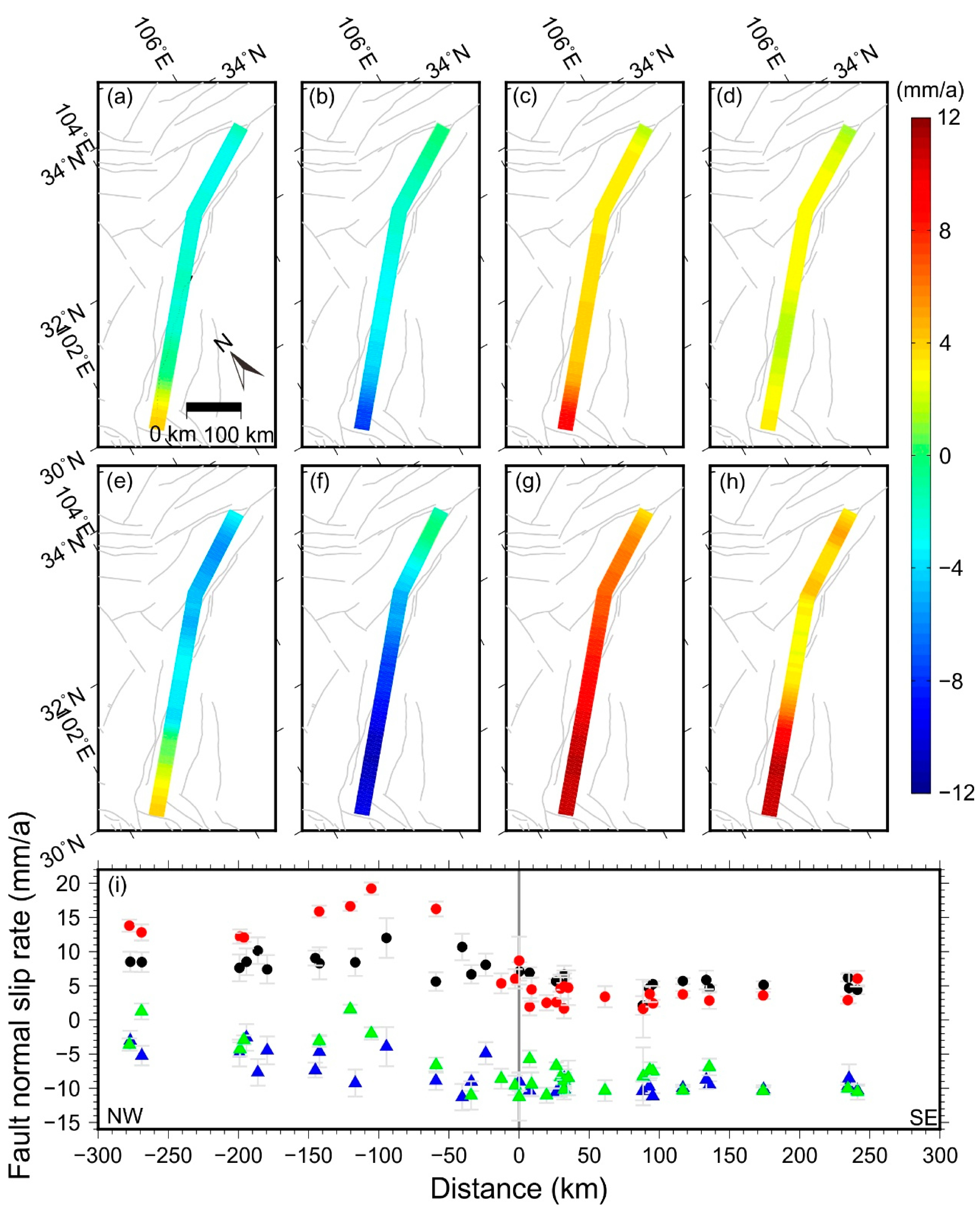
2.2. Modeling Strategies

We use the block modeling approach to estimate the block rotations, permanent strain within blocks, block-bounding fault slip rates, and fault coupling based on the GPS velocities data before and after the 2008 Mw 7.9 Wenchuan earthquake [29,30,31]. The process is implemented by the TDEFNODE package [30]. In this approach, the spatial variability of fault coupling is defined by the parameter ϕ (the coupling coefficient) [32]. If ϕ = 0, the fault is fully cree** or decoupled at a long-term slip rate. If ϕ = 1, the fault is fully coupled. To apply the block modeling approach to the crustal deformation after the 2008 Mw 7.9 Wenchuan earthquake, two prerequisites should be fulfilled—the movement and rotation of the upper crust are driven by the lower crust, and the upper crust is considered elastic even after the earthquake. The first prerequisite has long been proved, especially in the Eastern Tibetan Plateau (e.g., [33]). The upper crust is elastic after the 2008 Mw 7.9 Wenchuan earthquake is also reasonable, as the postseismic deformation derived from InSAR shows the viscoelastic lower crust below 45 km [34].
We divided the Eastern Tibetan Plateau into six blocks, namely, the South China block (SC), the Longmen Shan block (LM), the North Yunnan block (NY), the East Yunnan (EY), the Bayan Har block (BY), and the Lanzhou block (LZ) (Figure S2) [35]. Apart from the SC block, all the blocks are modeled to be elastic, implying that the three components of strain rate will be inverted to account for block internal deformation. We adopt the fault geometry along the central and northern LMSF of Shen et al. [6]. We model the southern LMSF to be listric in shape, with near surface fault dip angles decreasing from 40° to 24° at a depth of 30 km [36,37,38] (Figure S3). We discretize the fault model into many sub-faults, with an average 50 km along the strike and depth-dependent sampling along the downdip, which include 0.1, 4, 8, 12, 16, 20, and 30 km at depth. We solve ϕ for each sub-fault, which is further divided into 8 km × 4 km patches along the strike and downdip and interpolated by the bilinear method (Figure S3). A smoothing factor of 1.0 on the ϕ values along the strike is imposed, that is, the variation in ϕ values per degree of distance (~111 km) cannot be greater than 1.0. To account for the crustal deformation induced by surrounding coupled faults, such as the ** at the middle depth (5–20 km). Crusts of these two depths are thought to be difficult to accumulate enough strain energy for future big earthquakes. Additionally, fault coupling might be closely related to fault frictional strength and the state of fault stress (e.g., [8]). Thus, our fault coupling results suggest that the unilateral propagation of the 2008 Mw 7.9 Wenchuan earthquake is due to the fault strength heterogeneity between the northern and central LMSF. Indeed, some studies have reported that the fault strength of the LMSF zone might be rather inhomogeneous, compared to the faults in subduction zones or continental strike-slip faults (e.g., [36]). Furthermore, the geometry between the thrust movement due to long-term tectonic loading and the variations of the strike may have caused different states of stress along the LMSF, which, we suggest, results in different initial stress before the occurrence of the 2008 Mw 7.9 Wenchuan earthquake, which has caused the unilateral propagation to the northeast [48].

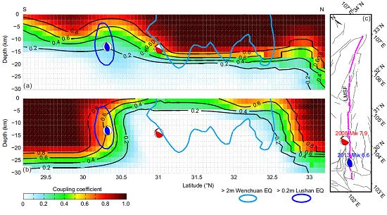
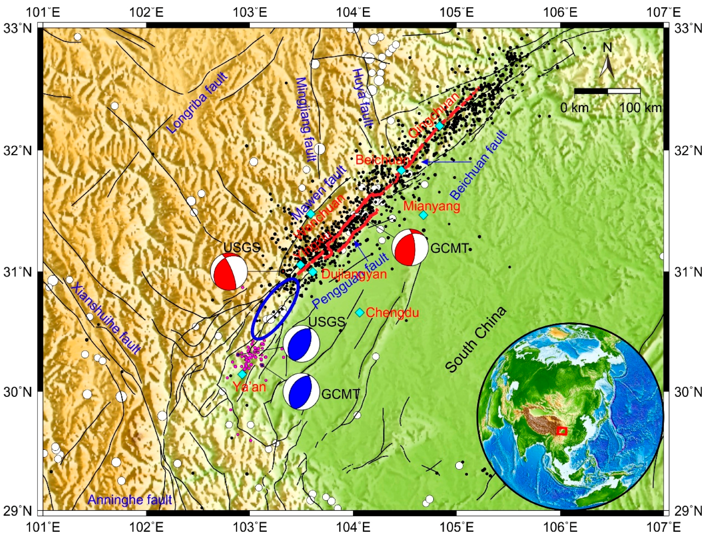
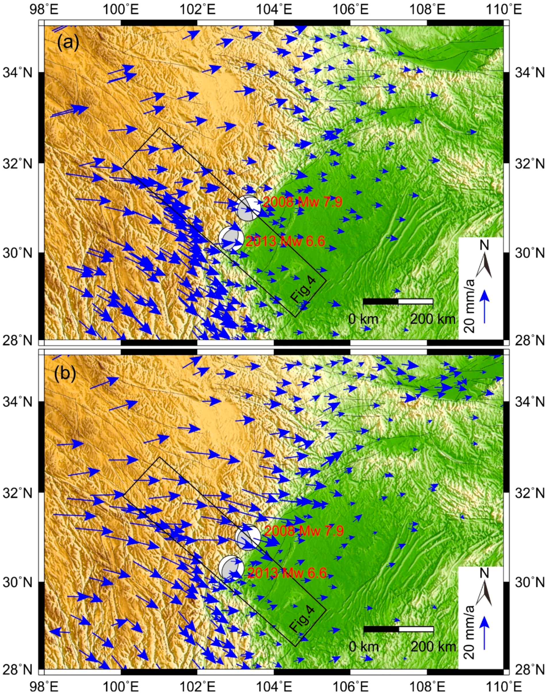
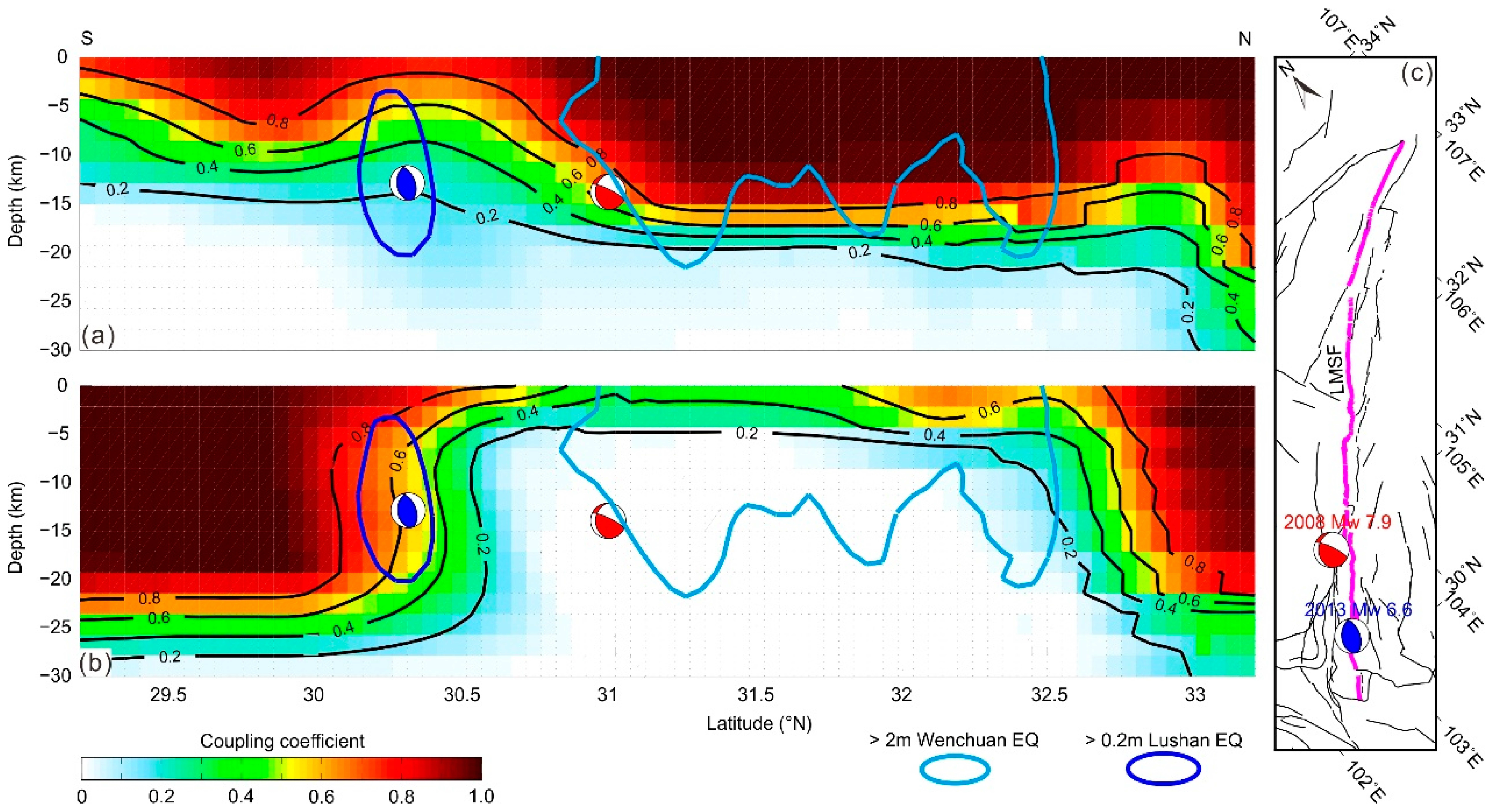
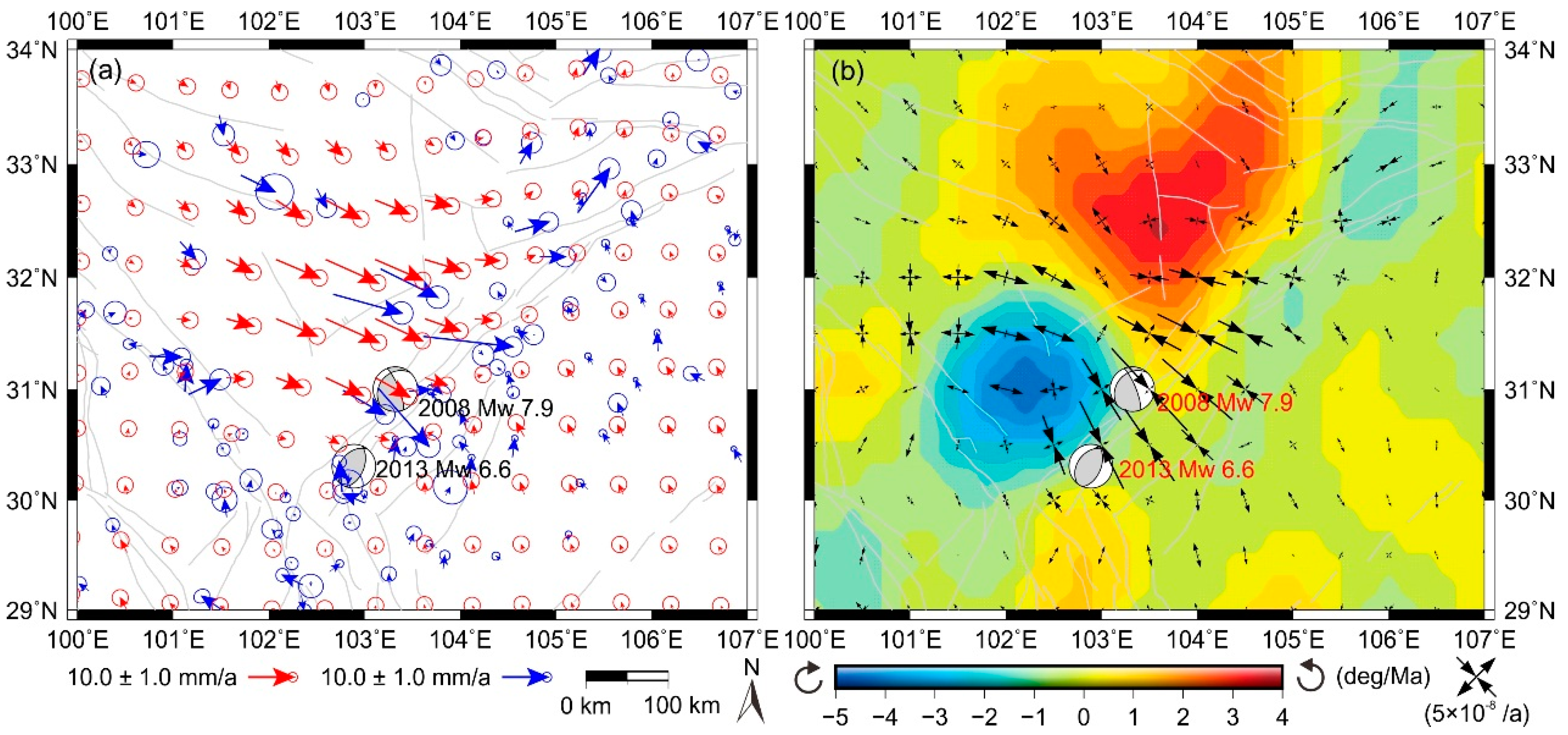
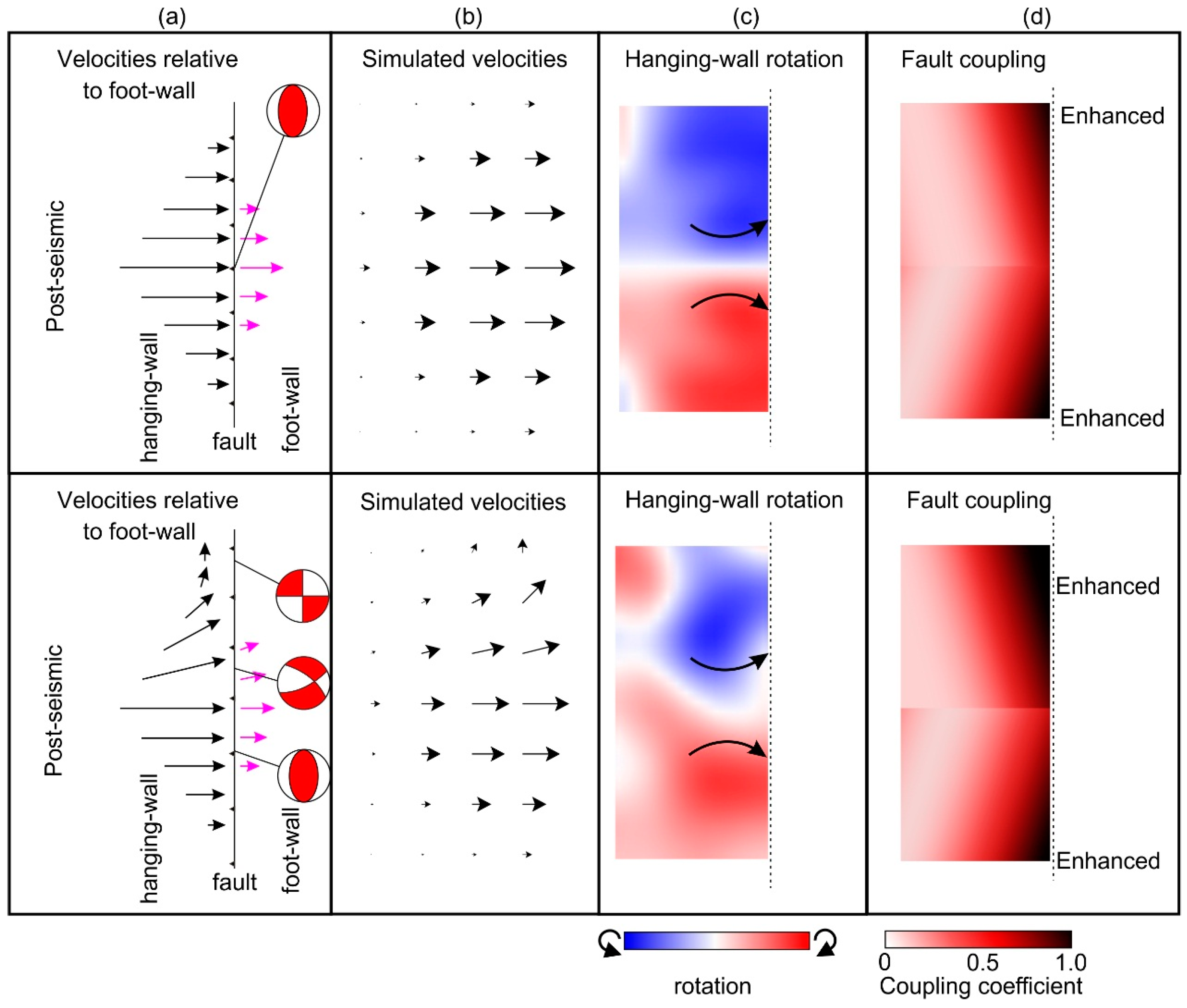
4.2. Nucleation and Occurrence of the 2013 Mw 6.6 Lushan Earthquake

Most studies suggest that both the co-seismic and postseismic Coulomb stress changes caused by the 2008 Mw 7.9 Wenchuan earthquake have advanced the occurrence of the 2013 Mw 6.6 Lushan earthquake, though they considered only a specific receiver fault (e.g., [14,18,21]). Our inversion results show that the hypocenter region of the 2013 Mw 6.6 Lushan earthquake was only loosely coupled, with a coupling coefficient of 0.3, before the occurrence of the 2008 Mw 7.9 Wenchuan earthquake, indicating that the southern LMSF was in an elastic strain accumulation deficit state or viscoelastic cree** state. The segments, however, were strongly coupled, with a coupling coefficient of 0.7, after the 2008 event, which is essential for the nucleation of earthquakes (Figure 3b).
In order to explore the relationship between the two events, a 0.5° × 0.5° interpolation was performed on the GPS velocity changes (the velocity after the 2008 Mw 7.9 Wenchuan earthquake minus the velocity before the earthquake) of the co-located sites. The interpolated velocities were then used to calculate the crustal rotation rates and principle strain rates. The GPS velocity changes may be driven by the postseismic deformation (e.g., viscoelastic relaxation of the lower crust) of the 2008 Mw 7.9 Wenchuan earthquake. Details of the calculation are given in the supplementary material. We find that the postseismic effect of the 2008 Mw 7.9 Wenchuan earthquake has caused the Eastern Tibetan Plateau to thrust eastward with an accelerating average rate of ~6–9 mm/a (Figure 4a–i and Figure 5a), and enhanced the compressive strain on the southern LMSF (Figure 5b). The decoupling of the central and northern LMSF and the postseismic deformation after the 2008 Mw 7.9 Wenchuan earthquake have accelerated the fault coupling and elastic strain accumulation on the southern LMSF, which contribute to the occurrence of the 2013 Mw 6.6 Lushan earthquake. For a more intuitive interpretation, we simulated the effect of postseismic deformation on a fault. Results show that the postseismic deformation could enhance the compression and shear stress on the fault plane, and accelerate the downward coupling and accumulation of elastic strain on the fault plane (Figure 6). Some more detailed information is also provided in the supplementary material. Moreover, the Coulomb stress loading imposed by the 2008 Mw 7.9 Wenchuan earthquake may have advanced the 2013 Mw 6.6 Lushan earthquake (e.g., [18,21]). Therefore, we suggest that the 2013 Mw 6.6 Lushan earthquake is a triggered event, considering the accelerating elastic strain accumulation and the Coulomb stress loading.

4.3. Was the 2013 Mw 6.6 Lushan Earthquake an Aftershock of the 2008 Mw 7.9 Wenchuan Earthquake?

Aftershocks are events that typically begin immediately following the mainshock over the entire rupture area and its surroundings [49]. Concerning whether the 2013 Mw 6.6 Lushan earthquake should be defined as an aftershock of the 2008 Mw 7.9 Wenchuan earthquake, controversial conclusions have been reached since the occurrence of the 2013 Mw 6.6 Lushan earthquake (e.g., [17,18]). For instance, Xu et al. [17] reported that the 2008 Mw 7.9 Wenchuan and the 2013 Mw 6.6 Lushan earthquake are independent rupturing events concerning their differences in rupture process, seismogenic structures, and aftershock distributions. By analyzing seismic reflection profiles, Li et al. [14] also suggested that the 2013 Mw 6.6 Lushan earthquake should be an independent event. On the other hand, Zhu [19] stated that the Lushan event should be one of the aftershocks, and possibly the largest one, of the 2008 Mw 7.9 Wenchuan mainshock, based on the analysis the statistical properties of the Wenchuan-Lushan earthquake sequence using three established empirical laws on aftershocks, i.e., the Gutenberg-Richter relation, modified Omori-Utsu law, and Båth’s law. In addition, Wang et al. [18] evaluated the Coulomb stress change caused by coseismic rupture and postseismic stress relaxation of the 2008 Mw 7.9 Wenchuan earthquake at the rupture zone of the 2013 Mw 6.6 Lushan earthquake, and compared it with the tectonic loading Coulomb stress on the fault since the 2008 Mw 7.9 Wenchuan earthquake. They concluded that the 2013 Mw 6.6 Lushan earthquake is at least 85% of a delayed aftershock of the 2008 Mw 7.9 Wenchuan earthquake.
To investigate whether the 2013 Mw 6.6 Lushan earthquake should be defined as an aftershock of the 2008 Mw 7.9 Wenchuan earthquake, we summed the accumulated geodetic seismic moment rates on each patch along the southern LMSF and got 1.35 × 10¹⁸ Nm/a accumulation rate between 2008 and 2013. Assuming the rate to be constant over this period, the accumulated strain is equivalent to an Mw 6.5 earthquake (6.76 × 10¹⁸ Nm), accounting for 71% of the seismic moment released in the 2013 Mw 6.6 Lushan earthquake. The remaining 29% might accumulate on the fault plane interseismically, as indicated by the shallowly (<5 km), but coupled, results before the 2008 Mw 7.9 Wenchuan earthquake (Figure 3a). As stated by Savage and Prescott [50], fault begins to couple and accumulate elastic strain during the interseismic phase and releases the accumulated seismic moment during the co-seismic rupture, which is a traditional earthquake cycle. Although much of the seismic moment has been accumulated after the 2008 Mw 7.9 Wenchuan earthquake, the accumulated seismic moment is exactly the amount foreseen by an aftershock event e.g., [12], and the elastic strain buildup has been provided mainly by the mainshock. Also note that aftershocks are typically defined as events that begin immediately following the mainshock over the entire rupture area and its surroundings [49]. The time interval between the 2008 Mw 7.9 Wenchuan earthquake and the 2013 Mw 6.6 Lushan earthquake reaches five years. However, the temporal window of one seismic sequence is somehow arbitrary, no consensus has been reached so far. Therefore, under the existing framework of knowledge (e.g., empirical laws), we propose that the 2013 Mw 6.6 Lushan earthquake should be defined as a “delayed aftershock” of the 2008 Mw 7.9 Wenchuan earthquake. The inference is consistent with that proposed by Wang et al. [18], but we argue from different perspectives.

4.4. Seismic Hazard along the Southern LMSF

After the 2013 Mw 6.6 Lushan earthquake, there are controversies about the seismic hazard along the segment of the “seismic gap” and the southern LMSF. For example, Chen et al. [12] calculated the moment deficit along the unruptured segments of the LMSF between the 2008 Mw 7.9 Wenchuan and the 2013 Mw 6.6 Lushan rupture zones, and stated there is a high seismic risk on the “seismic gap”, which might be capable of generating an Mw 6.6 earthquake. Li et al. [20] and Liu et al. [14,15] also suggested that the unruptured segment is most likely to produce a large earthquake (M ~7) by interpreting results from 3D a numerical interseismic deformation simulation and co-seismic Coulomb stress calculation. On the other hand, both geologic trenches and seismic profiling suggest a low probability of a large earthquake along the gap in the near future [13,46], which is also supported by our fault-coupling model. Before the 2008 Mw 7.9 Wenchuan earthquake, the “seismic gap” segment along the southern LMSF was shallowly coupled (<5 km) (Figure 3a). Thus, viscoelastic cree** is expected at a deeper depth under the coupled region because of the low fault coupling coefficient (<0.4). The calculated geodetic moment accumulation rate on the fault plane (0–20 km) along the “seismic gap” is 1.35 × 10¹⁶ Nm/a, only accounted for 1% of the entire LMSF. After the 2008 Mw 7.9 Wenchuan earthquake, the fault plane along the “seismic gap” was completely decoupled (fault coupling coefficient ~0.3) (Figure 3b). Since the elastic strain cannot accumulate in the cree** fault plane (e.g., [30,32]), the decoupled “seismic gap” is not capable of accumulating elastic strain. Thus, we conclude that the seismic risk is not high at the unruptured segments along the LMSF between the 2008 Mw 7.9 Wenchuan and the 2013 Mw 6.6 Lushan rupture zones.
However, our fault-coupling results show that the southernmost LMSF is coupled ~20 km deep both before and after the 2008 Mw 7.9 Wenchuan earthquake. Assuming a time scale of 1000 years and a constant seismic moment deficit along the southern LMSF, the accumulated moment should be 2.96 × 10²⁰ Nm. The 2013 Mw 6.6 Lushan earthquake has released only a small part (~1/30) of the accumulated elastic strain. The seismic moment deficit along the southern LMSF could be capable of generating an Mw 7.6 earthquake, so the seismic hazard there remains high, especially on the unruptured segment further southwest of the 2013 Mw 6.6 Lushan earthquake.

5. Conclusions

We introduce a block modeling approach constrained by horizontal GPS velocities before and after the 2008 Mw 7.9 Wenchuan earthquake to invert the fault coupling along the LMSF, to investigate the relationship between the 2008 Mw 7.9 Wenchuan earthquake and the 2013 Mw 6.6 Lushan earthquake. Our results show the fault coupling dramatically changed along the central and northern LMSF, with fault segments strongly coupled and locked at a depth of ~18 km before the 2008 Mw 7.9 Wenchuan earthquake and decoupled after the earthquake. The seismic gap between the two earthquake rupture zones is coupled within a 5 km depth before the earthquake, and decoupled after the earthquake. Segments along the southern LMSF, including regions around the hypocenter of the 2013 Mw 6.6 Lushan earthquake, however, are coupled from a depth of ~10 km to ~25 km. Moreover, by investigating the GPS velocity changes before and after the 2008 Mw 7.9 Wenchuan earthquake, we find that the postseismic deformation induced by the 2008 Mw 7.9 Wenchuan earthquake has caused the upper crust of Eastern Tibetan Plateau to thrust in an accelerating pace to the Sichuan block, which results in enhanced compression and shear stress on the LMSF. Consequently, downdip coupling of the fault, as well as the accelerating accumulation of the elastic strain, triggered the 2013 Mw 6.6 Lushan earthquake. Additionally, we quantitatively investigate the seismic moment accumulation and release along the southern LMSF. We propose that that the 2013 Mw 6.6 Lushan earthquake should be regarded as a “delayed” aftershock of the 2008 Mw 7.9 Wenchuan earthquake. Finally, we suggest that the seismic hazard potential along the southern LMSF remains high, especially on the unruptured segment further southwest of the 2013 Mw 6.6 Lushan earthquake.

Supplementary Materials

The following are available online at https://mdpi.longhoe.net/2072-4292/10/5/753/s1, Figure S1, Statistics of the residuals for GPS sites and time series. Figure S2, The block model and GPS velocity residuals. Figure S3, The geometry of the LMSF of our model. Figure S4, Resolution test for fault coupling modeling of the LMSF.

Author Contributions

Y.L. designed and conducted the experiment, processed the GPS data, summarized the research results, and wrote the manuscript; X.S. conducted the project, designed the experiment and summarized the research results; G.Z. summarized the research results and revised the draft; Y.L., C.Q. and X.S. provide insightful comments and suggestions about the interpretation of the 2008 Mw 7.9 Wenchuan earthquake and the 2013 Mw 6.6 Lushan earthquake; Y.W. and H.L. helped to process the GPS data. All authors have read the final manuscript.

Acknowledgments

The authors thank the five anonymous reviewers for their helpful comments and suggestions. Thanks for all of the colleagues who were involved in the GPS data collection. We are grateful to the Sichuan Earthquake Bureau for providing part of the GPS data. We also thank Robert McCaffrey, who has made his block model code (the TDEFNODE package) publicly available. This work was funded by the National Natural Science Foundation of China (no. 41631073), the scientific research project of the M 7.0 Jiuzhaigou, Sichuan earthquake, the Basic Scientific Funding of Institute of Geology, China Earthquake Administration (no. IGCEA1613) and the National Key Laboratory of Earthquake Dynamics (LED2015A03). Figures are generated by GMT software [51].

Conflicts of Interest

The authors declare no conflict of interest.

References

  1. Burchfiel, B.; Royden, L.; vander Hilst, R.; Hager, B.; Chen, Z.; King, R.; Li, C.; Lü, J.; Yao, H.; Kirby, E. A geological and geophysical context for the Wenchuan earthquake of 12 May 2008, Sichuan, People’s Republic of China. GSA Today 2008, 18, 4–11. [Google Scholar] [CrossRef]
  2. Xu, X.; Wen, X.; Yu, G.; Chen, G.; Klinger, Y.; Hubbard, J.; Shaw, J. Coseismic reverse- and oblique-slip surface faulting generated by the 2008 Mw 7.9 Wenchuan earthquake, China. Geology 2009, 37, 515–518. [Google Scholar] [CrossRef]
  3. Royden, L.; Burchfiel, B.; King, R.; Wang, E.; Chen, L.; Shen, F.; Liu, P. Surface deformation and lower crustal flow in eastern Tibet. Science 1997, 276, 788–790. [Google Scholar] [CrossRef] [PubMed]
  4. Tapponnier, P.; Xu, Z.; Roger, F.; Meyer, B.; Arnaud, N.; Wittlinger, G.; Yang, J. Oblique stepwise rise and growth of the Tibet Plateau. Science 2001, 294, 1671–1677. [Google Scholar] [CrossRef] [PubMed]
  5. Liu-Zeng, J.; Zhang, Z.; Wen, L.; Tapponnier, P.; Sun, J.; ** tools: Improved version released. Eos Trans. AGU 2013, 94, 409–410. [Google Scholar] [CrossRef]
Figure 1. Regional tectonic map of the Longmen Shan region. White dots represent background seismicity before 2008 (1930–2008, USGS—U.S. Geological Survey). Black dots are the aftershocks of the 2008 Mw 7.9 Wenchuan earthquake (until April 2013, USGS). Magenta dots show aftershocks of the 2013 Mw 6.6 Lushan earthquake (till March 2016, USGS). The focal mechanisms shown in red and blue beach balls, which come from the USGS and Global CMT, correspond to the 2008 Mw 7.9 Wenchuan earthquake and the 2013 Mw 6.6 Lushan earthquake, respectively. Black and red lines indicate regional faults and surface traces of co-seismic rupture of the Wenchuan earthquake [2]. The blue oval shows the approximate location of the “seismic gap” caused by the 2008 Mw 7.9 Wenchuan earthquake and the 2013 Mw 6.6 Lushan earthquake. The central and northern LMSF are located to the northeast of the gap, and the southern LMSF to the southwest. Green diamonds indicate the main cities or residential areas. Image overlain on the 30 m Shuttle Radar Topography Mission Digital Elevation Database (SRTM DEM). The red rectangle in the inset shows the study area.
Remotesensing 10 00753 g001
Figure 2. Measured motion of GPS sites in the Eastern Tibetan Plateau before (a) [23] and after (b) the 2008 Mw 7.9 Wenchuan earthquake. GPS velocity vectors are relative to the Eurasia fixed frame. For clarity, the error ellipses are not shown. Grey lines indicate regional faults. The black rectangle marks the location of the cross-fault profile in Figure 4i.
Remotesensing 10 00753 g002
Figure 3. Fault coupling of the LMSF before (a) and after (b) the 2008 Mw 7.9 Wenchuan earthquake. White to reddish brown indicates the fault coupling coefficient. The red and blue focal mechanisms indicate epicentres of the 2008 Mw 7.9 Wenchuan earthquake and the 2013 Mw 6.6 Lushan earthquake respectively. The region of co-seismic slip > 2 m of the 2008 Mw 7.9 Wenchuan earthquake is outlined by the light blue line [6]. The region of co-seismic slip > 0.2 m of the 2013 Mw 6.6 Lushan earthquake is outlined by the blue line [37]. Black lines indicate fault coupling coefficient contours; and (c) oblique projection of regional faults in the Eastern Tibetan Plateau. The bold magenta line shows the surface trance of the LMSF in our model.
Remotesensing 10 00753 g003
Figure 4. Statistics of the fault parallel slip rate (a,e); fault normal slip rate (b,f); total magnitude of slip rate (c,g); and the slip rate deficit (d,h) along the LMSF before (ad) and after (eh) the 2008 Mw 7.9 Wenchuan earthquake. Positive values indicate right-lateral or divergence; and (i) the GPS velocities across the southern LMSF. Black dots and red dots indicate fault-parallel velocity components before and after the 2008 Mw 7.9 Wenchuan earthquake. Green triangles and blue triangles represent fault-normal velocity components before and after the 2008 Mw 7.9 Wenchuan earthquake. Error bars are in 1-σ.
Remotesensing 10 00753 g004
Figure 5. (a) The GPS velocity changes before and after the 2008 Mw 7.9 Wenchuan earthquake. Blue vectors indicate the crustal deformation after the 2008 Mw 7.9 Wenchuan earthquake, which are the difference between the 1999–2007 GPS velocities and the 2009–2013 GPS velocities. Error ellipses show the 95% confidence levels in 1-σ. Arrows in red indicate the interpolated velocity changes using the least squares collocation algorithm; and (b) the derived strain rate based on the interpolated postseismic deformation. The background colors indicate the crustal rotation rates derived from the GPS data, red indicates counterclockwise rotation and blue indicates clockwise rotation. Two arrows opposing each other indicate the extensional and compressional principal strain rates, respectively. Thin grey lines correspond to active faults. The focal mechanisms of the 2008 Mw 7.9 Wenchuan earthquake and the 2013 Mw 6.6 Lushan earthquake are also shown.
Remotesensing 10 00753 g005
Figure 6. Sketch of the postseismic deformation model. (a) The assumed postseismic deformation and the corresponding kinematic characteristics of the fault; (b) the interpolated postseismic deformation velocity field by using the least-squares collocation method; (c) the derived crustal rotation rate of the hanging wall; and (d) the change of the fault coupling caused by the hanging wall rotation.
Remotesensing 10 00753 g006

