Evaluation of Different Machine Learning Methods and Deep-Learning Convolutional Neural Networks for Landslide Detection

 ,
,  ,
,  ,
,  ,
,  and
and 
Abstract
:
1. Introduction
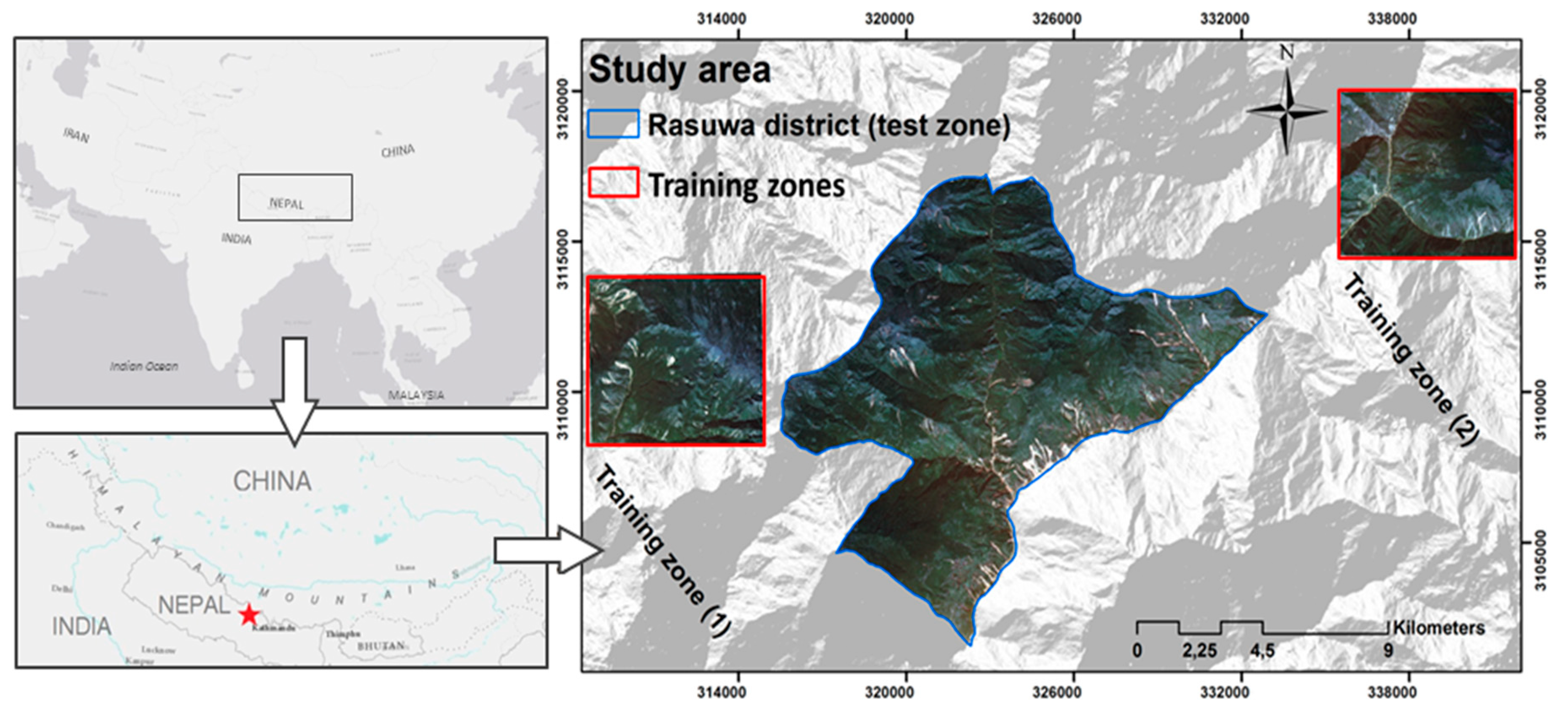
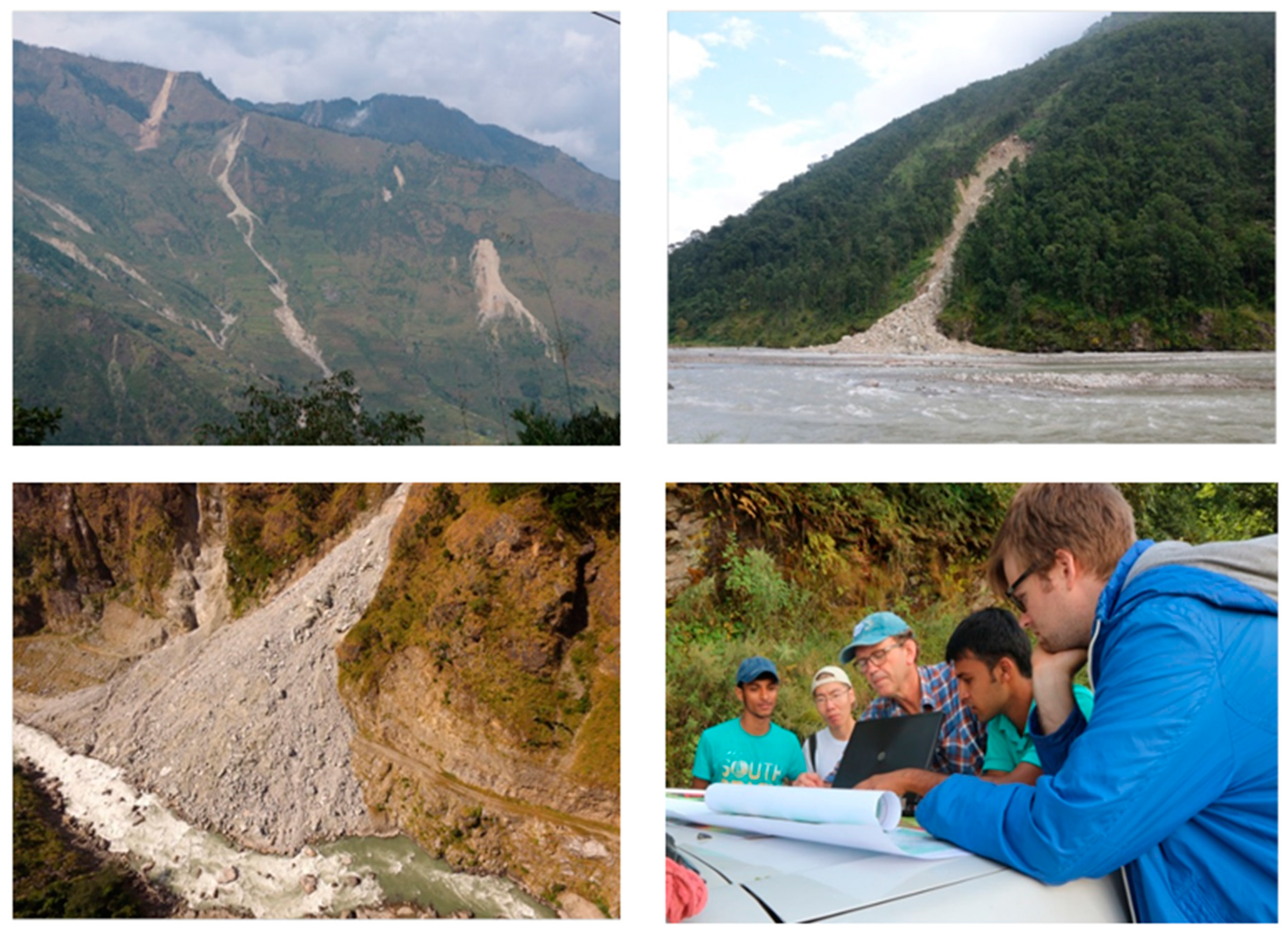
2. Overview of the Study Area
3. Workflow
3.1. Overall Methodology
- Designing two different training data sets, a) spectral information only, and b) a data set containing both spectral information and topographic factors.
- Applying ANN, SVM and RF methods for landslide detection based on both training data sets and validating the performance for the study area.
- Generating CNN-based patches by considering multiple window sizes from small to large ones.
- Develo** a data augmentation approach for increasing the number of training data sets used for CNNs.
- Structuring CNNs with different layer depths in regard to the range of input window size CNN patches to determine the most efficient CNN setting.
- Testing and validating the performances of each method by using multiple parameters.
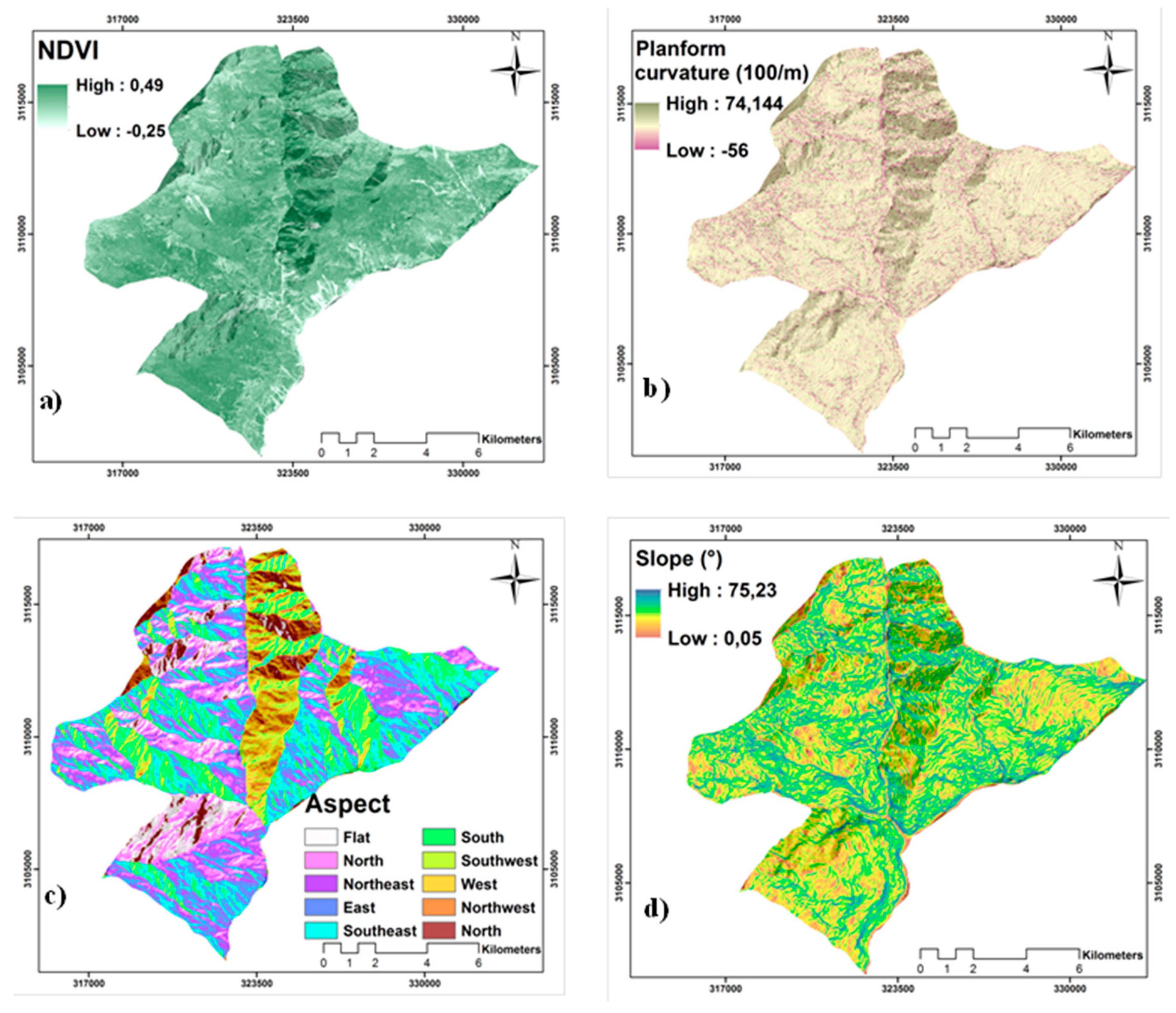
3.2. Data
3.3. Random Forest (RF)
3.4. Support Vector Machines (SVM)
3.5. Artificial Neural Network (ANN)
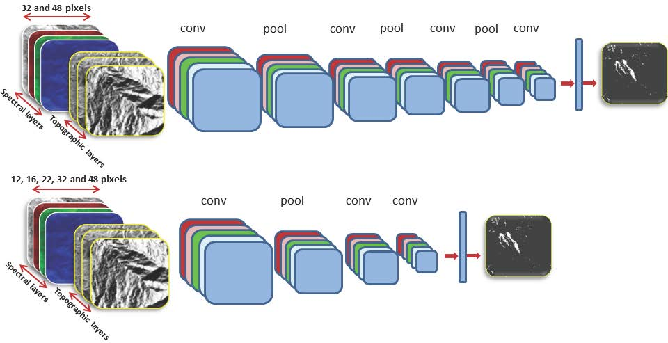
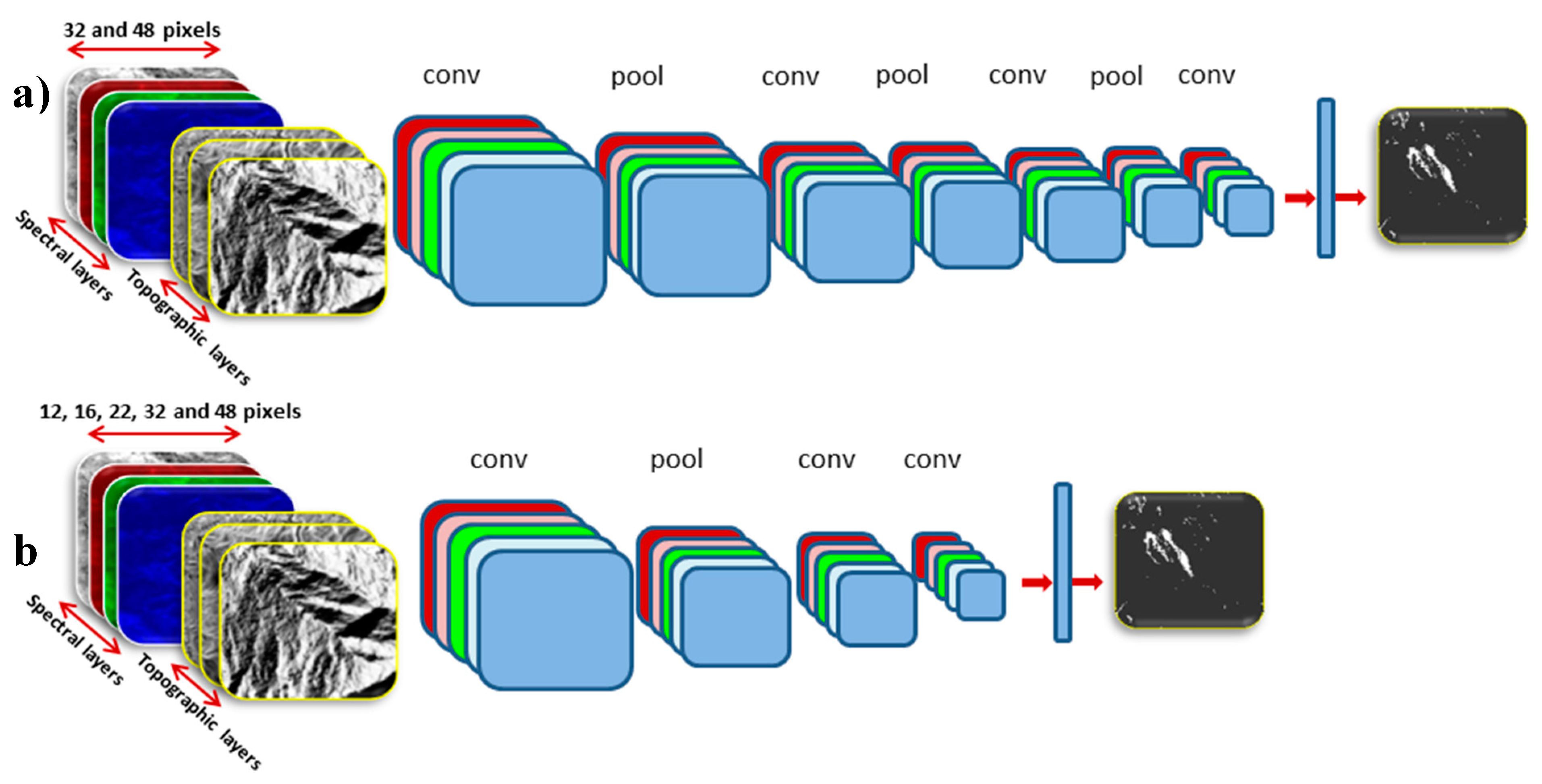
3.6. Convolution Neural Network (CNN)
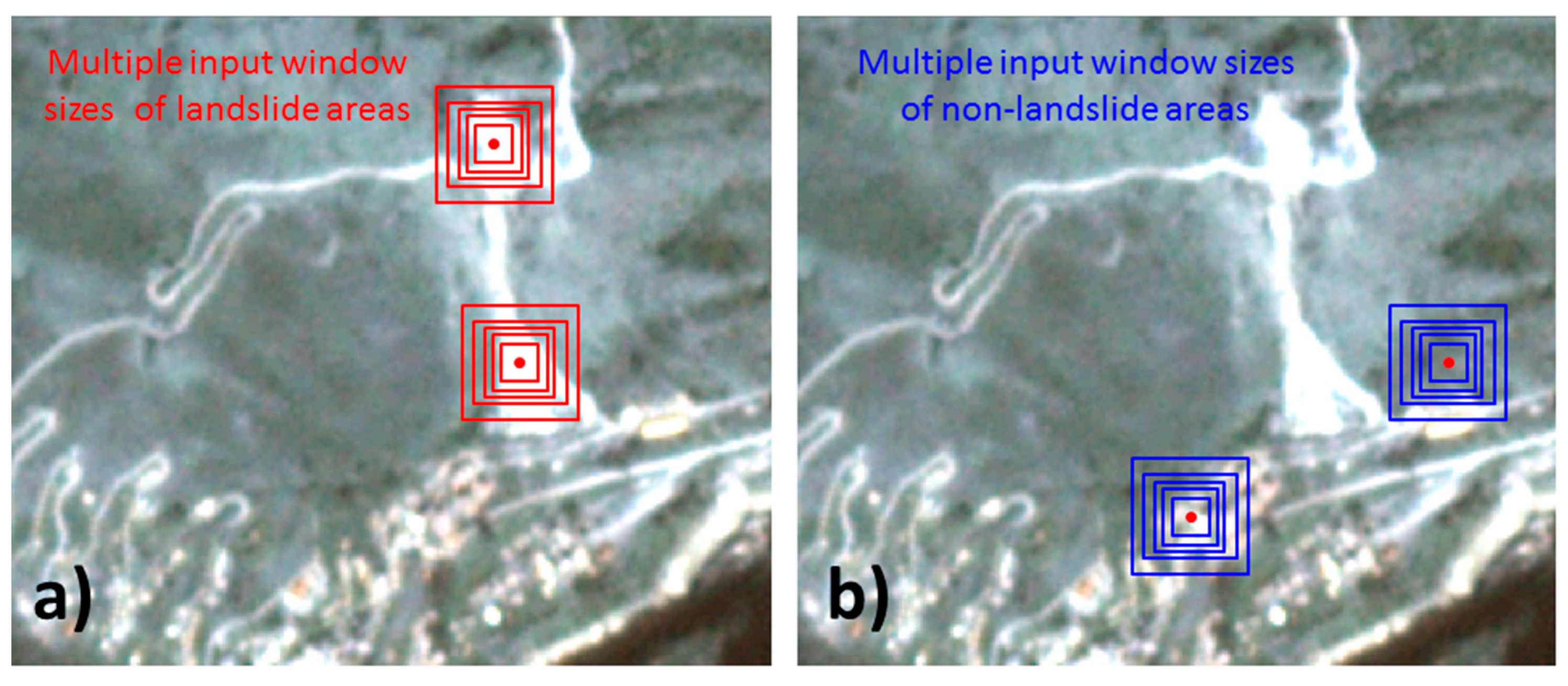
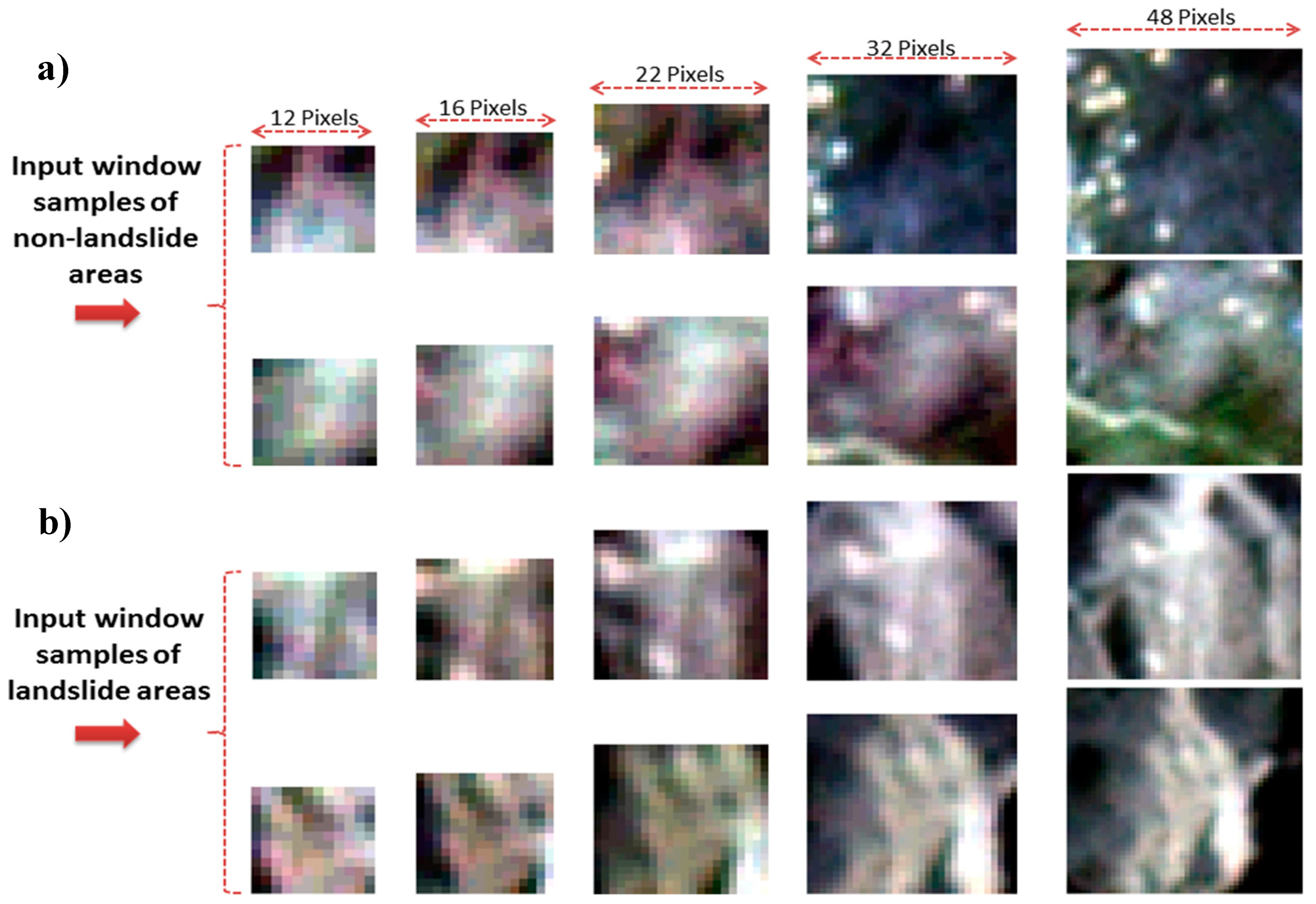
3.6.1. Multiple Input Window Size CNNs
3.6.2. Augmentation of the Training Data Set
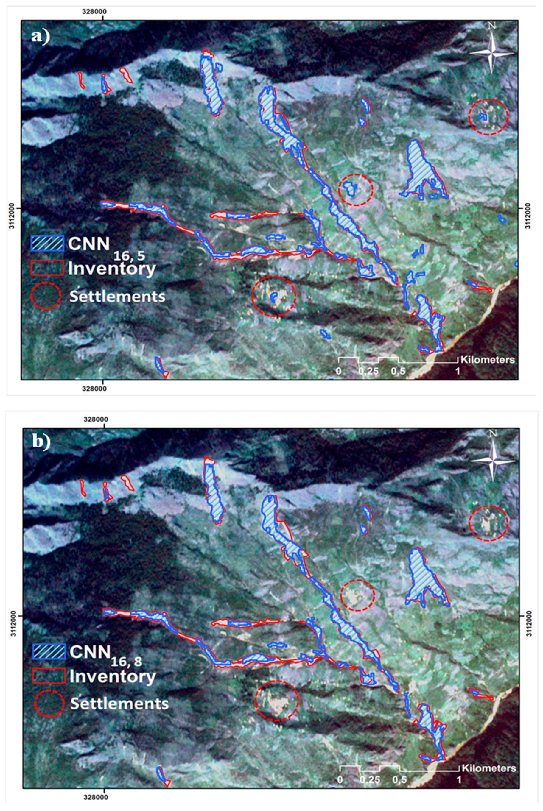
3.6.3. Different Layer Depth CNNs
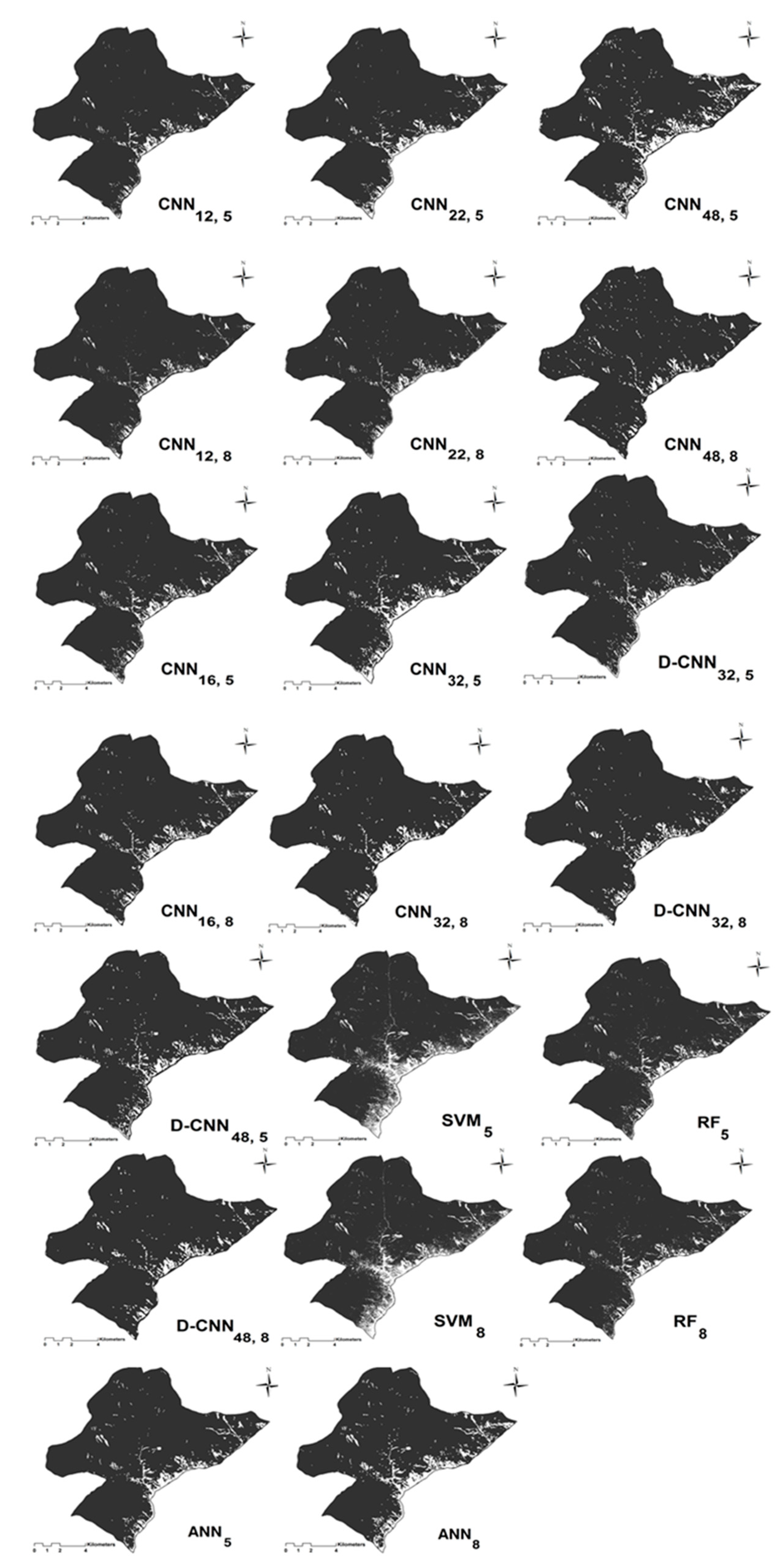
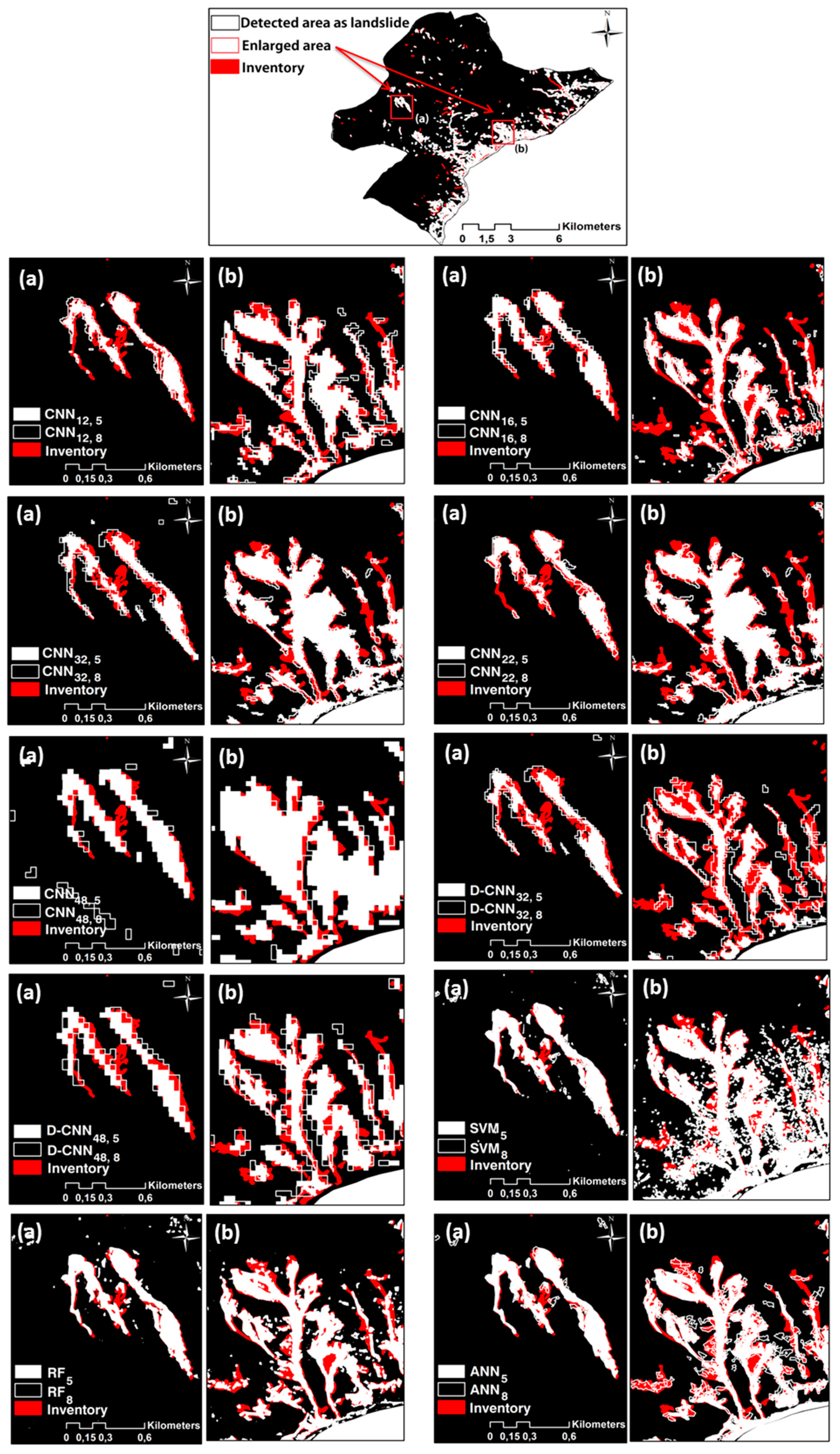
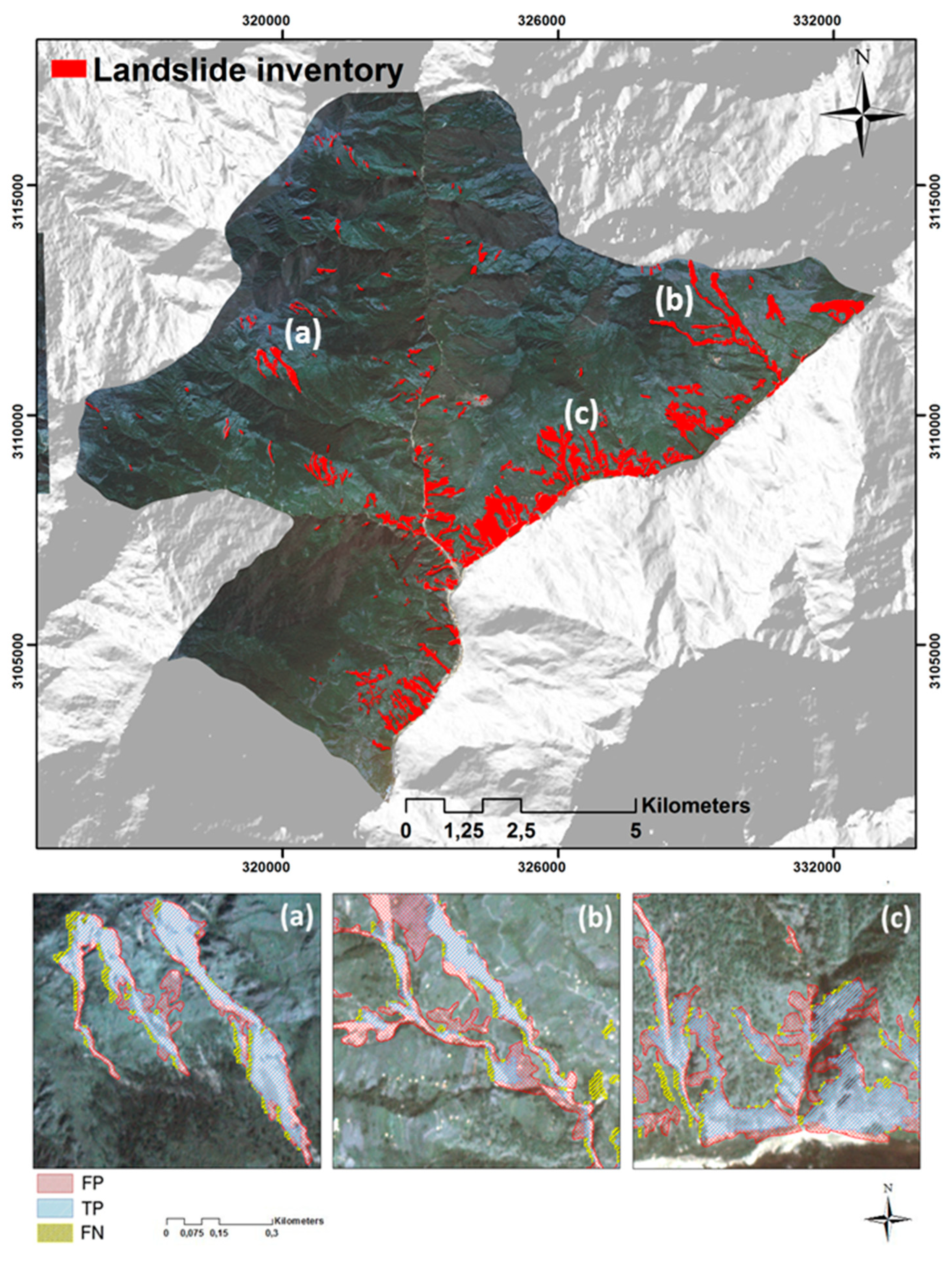
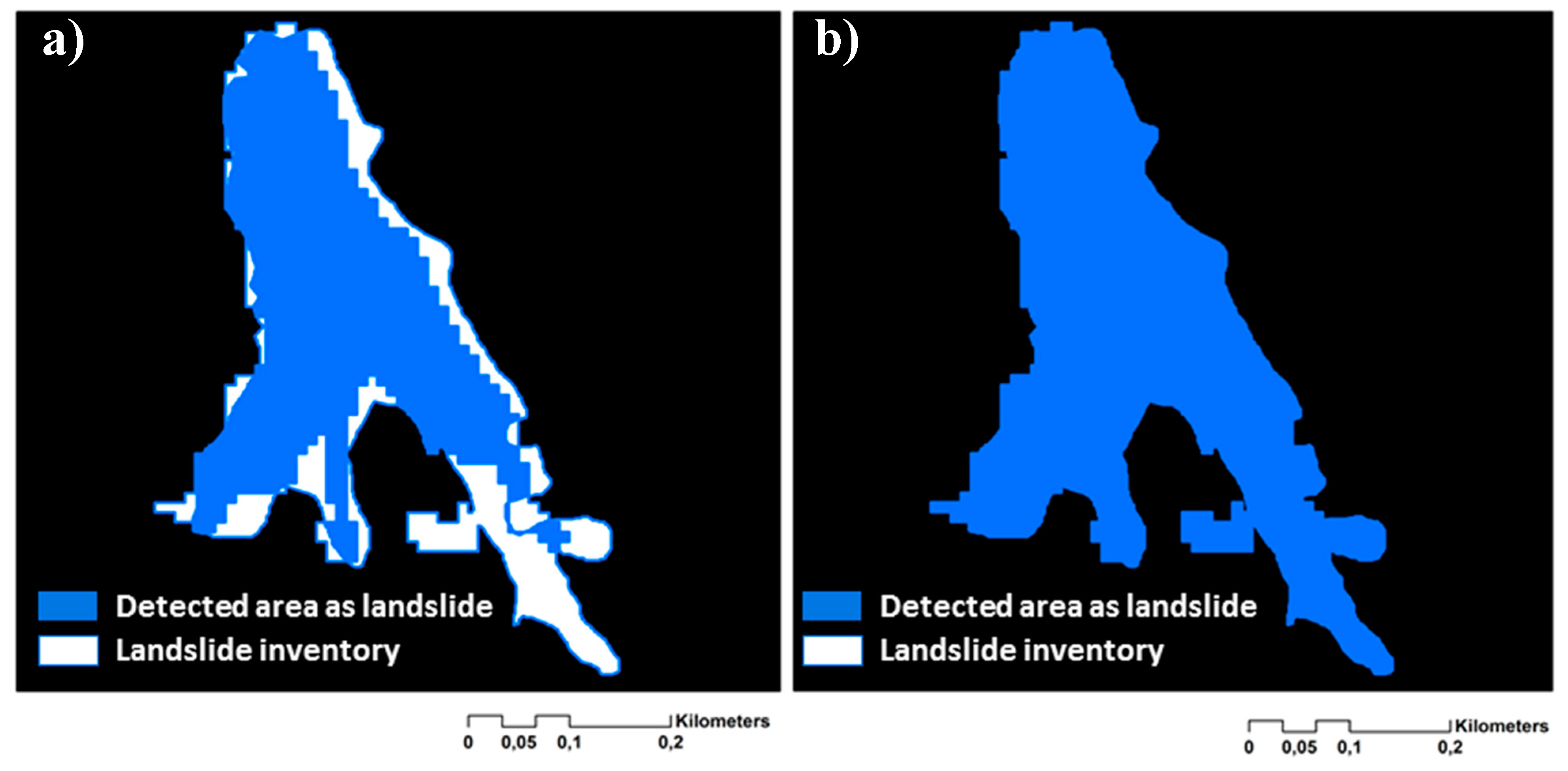
4. Results
5. Accuracy Assessment
5.1. Quantitative Methods
5.2. Mean Intersection-over-Union (mIOU)
6. Discussion
7. Conclusions
Author Contributions
Funding
Conflicts of Interest
References
- Pourghasemi, H.; Gayen, A.; Park, S.; Lee, C.-W.; Lee, S. Assessment of landslide-prone areas and their zonation using logistic regression, logitboost, and naïvebayes machine-learning algorithms. Sustainability 2018, 10, 3697. [Google Scholar] [CrossRef]
- Hölbling, D.; Füreder, P.; Antolini, F.; Cigna, F.; Casagli, N.; Lang, S. A semi-automated object-based approach for landslide detection validated by persistent scatterer interferometry measures and landslide inventories. Remote Sens. 2012, 4, 1310–1336. [Google Scholar] [CrossRef]
- Hong, H.; Chen, W.; Xu, C.; Youssef, A.M.; Pradhan, B.; Tien Bui, D. Rainfall-induced landslide susceptibility assessment at the Chongren area (China) using frequency ratio, certainty factor, and index of entropy. Geocarto Int. 2017, 32, 139–154. [Google Scholar] [CrossRef]
- Pradhan, B. A comparative study on the predictive ability of the decision tree, support vector machine and neuro-fuzzy models in landslide susceptibility map** using GIS. Comput. Geosci. 2013, 51, 350–365. [Google Scholar] [CrossRef] [Green Version]
- Solway, L. Socio-economic perspective of develo** country megacities vulnerable to flood and landslide hazards. In Floods and Landslides: Integrated Risk Assessment; Springer: Berlin, Heidelberg, 1999; pp. 245–260. [Google Scholar]
- Svalova, V. Landslide risk management for urbanized territories. In Risk Management Treatise for Engineering Practitioners; Oduoza, C.F., Ed.; IntechOpen: London, UK, 2018. [Google Scholar]
- Cascini, L.; Bonnard, C.; Corominas, J.; Jibson, R.; Montero-Olarte, J. Landslide hazard and risk zoning for urban planning and development. In Landslide Risk Management; Hungr, O., Fell, R., Couture, R., Eberhardt, E., Eds.; Taylor & Francis: London, UK, 2005; pp. 199–235. [Google Scholar]
- Martire, D.; De Rosa, M.; Pesce, V.; Santangelo, M.A.; Calcaterra, D. Landslide hazard and land management in high-density urban areas of Campania region, Italy. Nat. Hazards Earth Syst. Sci. 2012, 12, 905–926. [Google Scholar] [CrossRef] [Green Version]
- Mezaal, M.; Pradhan, B.; Rizeei, H. Improving landslide detection from airborne laser scanning data using optimized Dempster–Shafer. Remote Sens. 2018, 10, 1029. [Google Scholar] [CrossRef]
- Feizizadeh, B.; Ghorbanzadeh, O. GIS-based interval pairwise comparison matrices as a novel approach for optimizing an analytical hierarchy process and multiple criteria weighting. GI_Forum 2017, 1, 27–35. [Google Scholar] [CrossRef]
- Myronidis, D.; Papageorgiou, C.; Theophanous, S. Landslide susceptibility map** based on landslide history and analytic hierarchy process (AHP). Nat. Hazards 2016, 81, 245–263. [Google Scholar] [CrossRef]
- Aghdam, I.N.; Varzandeh, M.H.M.; Pradhan, B. Landslide susceptibility map** using an ensemble statistical index (wi) and adaptive neuro-fuzzy inference system (ANFIS) model at Alborz mountains (Iran). Environ. Earth Sci. 2016, 75, 553. [Google Scholar] [CrossRef]
- Sezer, E.A.; Pradhan, B.; Gokceoglu, C. Manifestation of an adaptive neuro-fuzzy model on landslide susceptibility map**: Klang valley, Malaysia. Expert Syst. Appl. 2011, 38, 8208–8219. [Google Scholar] [CrossRef]
- Pourghasemi, H.R.; Kerle, N. Random forests and evidential belief function-based landslide susceptibility assessment in western Mazandaran province, Iran. Environ. Earth Sci. 2016, 75, 185. [Google Scholar] [CrossRef]
- Chen, W.; **. J. Spat. Sci. 2018, 1–17. [Google Scholar] [CrossRef]
- Ghorbanzadeh, O.; Rostamzadeh, H.; Blaschke, T.; Gholaminia, K.; Aryal, J. A new GIS-based data mining technique using an adaptive neuro-fuzzy inference system (ANFIS) and k-fold cross-validation approach for land subsidence susceptibility map**. Nat. Hazards 2018, 1–21. [Google Scholar] [CrossRef]
- Feizizadeh, B.; Roodposhti, M.S.; Jankowski, P.; Blaschke, T. A GIS-based extended fuzzy multi-criteria evaluation for landslide susceptibility map**. Comput. Geosci. 2014, 73, 208–221. [Google Scholar] [CrossRef] [PubMed] [Green Version]
- Voigt, S.; Kemper, T.; Riedlinger, T.; Kiefl, R.; Scholte, K.; Mehl, H. Satellite image analysis for disaster and crisis-management support. IEEE Trans. Geosci. Remote Sens. 2007, 45, 1520–1528. [Google Scholar] [CrossRef]
- Plank, S.; Twele, A.; Martinis, S. Landslide map** in vegetated areas using change detection based on optical and polarimetric SAR data. Remote Sens. 2016, 8, 307. [Google Scholar] [CrossRef]
- Guzzetti, F.; Mondini, A.C.; Cardinali, M.; Fiorucci, F.; Santangelo, M.; Chang, K.-T. Landslide inventory maps: New tools for an old problem. Earth-Sci. Rev. 2012, 112, 42–66. [Google Scholar] [CrossRef] [Green Version]
- Manconi, A.; Casu, F.; Ardizzone, F.; Bonano, M.; Cardinali, M.; De Luca, C.; Gueguen, E.; Marchesini, I.; Parise, M.; Vennari, C. Brief communication: Rapid map** of landslide events: The 3 December 2013 Montescaglioso landslide, Italy. Nat. Hazards Earth Syst. Sci. 2014, 14, 1835–1841. [Google Scholar] [CrossRef]
- Lang, S.; Schöpfer, E.; Zeil, P.; Riedler, B. Earth observation for humanitarian assistance. GI Forum–J. Geogr. Inf. Sci. 2017, 1, 157–165. [Google Scholar] [CrossRef]
- Blaschke, T. Object based image analysis for remote sensing. ISPRS J. Photogramm. Remote Sens. 2010, 65, 2–16. [Google Scholar] [CrossRef] [Green Version]
- Duro, D.C.; Franklin, S.E.; Dubé, M.G. A comparison of pixel-based and object-based image analysis with selected machine learning algorithms for the classification of agricultural landscapes using Spot-5 HRG imagery. Remote Sens. Environ. 2012, 118, 259–272. [Google Scholar] [CrossRef]
- Roodposhti, M.S.; Aryal, J.; Bryan, B.A. A novel algorithm for calculating transition potential in cellular automata models of land-use/cover change. Environ. Model. Softw. 2019, 112, 70–81. [Google Scholar] [CrossRef]
- Mezaal, M.R.; Pradhan, B.; Sameen, M.I.; Mohd Shafri, H.Z.; Yusoff, Z.M. Optimized neural architecture for automatic landslide detection from high-resolution airborne laser scanning data. Appl. Sci. 2017, 7, 730. [Google Scholar] [CrossRef]
- Danneels, G.; Pirard, E.; Havenith, H.-B. Automatic landslide detection from remote sensing images using supervised classification methods. In Proceedings of the IEEE International Geoscience and Remote Sensing Symposium, IGARSS 2007, Barcelona, Spain, 23–28 July 2007; IEEE: Barcelona, Spain, 2007; pp. 3014–3017. [Google Scholar]
- Bui, D.T.; Tuan, T.A.; Klempe, H.; Pradhan, B.; Revhaug, I. Spatial prediction models for shallow landslide hazards: A comparative assessment of the efficacy of support vector machines, artificial neural networks, kernel logistic regression, and logistic model tree. Landslides 2016, 13, 361–378. [Google Scholar]
- Zhu, X.X.; Tuia, D.; Mou, L.; ** using multispectral remote sensing imagery. Remote Sens. 2018, 10, 1119. [Google Scholar] [CrossRef]
- Modzelewska, A.; Stereńczak, K.; Mierczyk, M.; Maciuk, S.; Bałazy, R.; Zawiła-Niedźwiecki, T. Sensitivity of vegetation indices in relation to parameters of Norway spruce stands. Folia Forestalia Polonica 2017, 59, 85–98. [Google Scholar] [CrossRef] [Green Version]
- Ohlmacher, G.C. Plan curvature and landslide probability in regions dominated by earth flows and earth slides. Eng. Geol. 2007, 91, 117–134. [Google Scholar] [CrossRef]
- Breiman, L. Random forests. Mach. Learn. 2001, 45, 5–32. [Google Scholar] [CrossRef]
- Melville, B.; Lucieer, A.; Aryal, J. Object-based random forest classification of Landsat ETM+ and worldview-2 satellite imagery for map** lowland native grassland communities in Tasmania, Australia. Int. J. Appl. Earth Obs. Geoinf. 2018, 66, 46–55. [Google Scholar] [CrossRef]
- Xu, R.; Lin, H.; Lü, Y.; Luo, Y.; Ren, Y.; Comber, A. A modified change vector approach for quantifying land cover change. Remote Sens. 2018, 10, 1578. [Google Scholar] [CrossRef]
- Chen, T.; Trinder, J.C.; Niu, R. Object-oriented landslide map** using ZY-3 satellite imagery, random forest and mathematical morphology, for the three-gorges reservoir, china. Remote Sens. 2017, 9, 333. [Google Scholar] [CrossRef]
- Vapnik, V. Statistical Learning Theory; Wiley: New York, NY, USA, 1998; Volume 3. [Google Scholar]
- Janik, P.; Lobos, T. Automated classification of power-quality disturbances using SVM and RBF networks. IEEE Trans. Power Deliv. 2006, 21, 1663–1669. [Google Scholar] [CrossRef]
- Goldarag, Y.J.; Mohammadzadeh, A.; Ardakani, A. Fire risk assessment using neural network and logistic regression. J. Indian Soc. Remote Sens. 2016, 44, 885–894. [Google Scholar] [CrossRef]
- Paola, J.; Schowengerdt, R. A review and analysis of backpropagation neural networks for classification of remotely-sensed multi-spectral imagery. Int. J. Remote Sens. 1995, 16, 3033–3058. [Google Scholar] [CrossRef]
- Park, S.; Choi, C.; Kim, B.; Kim, J. Landslide susceptibility map** using frequency ratio, analytic hierarchy process, logistic regression, and artificial neural network methods at the Inje area, Korea. Environ. Earth Sci. 2013, 68, 1443–1464. [Google Scholar] [CrossRef]
- Zhang, C.; Sargent, I.; Pan, X.; Li, H.; Gardiner, A.; Hare, J.; Atkinson, P.M. An object-based convolutional neural network (OCNN) for urban land use classification. Remote Sens. Environ. 2018, 216, 57–70. [Google Scholar] [CrossRef]
- Strigl, D.; Kofler, K.; Podlipnig, S. Performance and scalability of GPU-based convolutional neural networks. In Proceedings of the 2010 18th Euromicro International Conference on Parallel, Distributed and Network-Based Processing (PDP), Pisa, Italy, 17–19 February 2010; IEEE: Pisa, Italy, 2010; pp. 317–324. [Google Scholar]
- Dixit, M.; Kwitt, R.; Niethammer, M.; Vasconcelos, N. Attribute-guided augmentation. In Proceedings of the IEEE Conference on Computer Vision and Pattern Recognition, Honolulu, HI, USA, 21–26 July 2017; pp. 7455–7463. [Google Scholar]
- Liu, B.; Dixit, M.; Kwitt, R.; Vasconcelos, N. Feature space transfer for data augmentation. In Proceedings of the IEEE Conference on Computer Vision and Pattern Recognition, Salt Lake City, UT, USA, 18–20 June 2018; pp. 9090–9098. [Google Scholar]
- Csillik, O.; Cherbini, J.; Johnson, R.; Lyons, A.; Kelly, M. Identification of citrus trees from unmanned aerial vehicle imagery using convolutional neural networks. Drones 2018, 2, 39. [Google Scholar] [CrossRef]
- Chen, L.-C.; Barron, J.T.; Papandreou, G.; Murphy, K.; Yuille, A.L. Semantic image segmentation with task-specific edge detection using cnns and a discriminatively trained domain transform. In Proceedings of the IEEE Conference on Computer Vision and Pattern Recognition, Las Vegas, NV, USA, 26 June–1 July 2016; pp. 4545–4554. [Google Scholar]
- Dou, J.; Chang, K.-T.; Chen, S.; Yunus, A.P.; Liu, J.-K.; **a, H.; Zhu, Z. Automatic case-based reasoning approach for landslide detection: Integration of object-oriented image analysis and a genetic algorithm. Remote Sens. 2015, 7, 4318–4342. [Google Scholar] [CrossRef]
- Blaschke, T.; Piralilou, S.T. The near-decomposability paradigm re-interpreted for place-based GIS. In Proceedings of the 1st Workshop on Platial Analysis (PLATIAL’18), Heidelberg, Germany, 20–21 September 2018; pp. 20–21. [Google Scholar]


| Prepared by | # Landslides | Shape | Coverage | Study Reference |
|---|---|---|---|---|
| USGS | 24915 | Polygon | Gorkha, Nepal | [44] |
| IMHE, CAS | 2645 | Polygon | Gorkha, Nepal | [45] |
| Gnyawali and Adhikari 2016 | 19332 | Point | Gorkha, Nepal | [46] |
| Method | Count | Minimum (ha) | Maximum (ha) | Sum (ha) | Mean (ha) | Standard Deviation (ha) |
|---|---|---|---|---|---|---|
| 247 | 0.175 | 77.16 | 555,63 | 1.54 | 5.37 | |
| 308 | 0.2 | 54.65 | 530,63 | 1.99 | 6.51 | |
| 281 | 0.175 | 96.32 | 480,52 | 1.15 | 4.97 | |
| 321 | 0.18 | 157.64 | 447,28 | 1.65 | 7.08 | |
| 286 | 0.175 | 136.85 | 524,32 | 1.89 | 9.75 | |
| 341 | 0.185 | 170.05 | 426,05 | 0.96 | 4.59 | |
| 306 | 0.21 | 208.48 | 784,79 | 1.93 | 11.08 | |
| 335 | 0.205 | 174.4 | 508,31 | 2.16 | 6.43 | |
| 314 | 0.2 | 204.8 | 426,83 | 2.37 | 11.23 | |
| 385 | 0.22 | 154.72 | 478,02 | 1.1 | 3.46 | |
| D- | 268 | 0.195 | 58.87 | 467,52 | 1.27 | 4.28 |
| D- | 277 | 0.2 | 76 | 509,83 | 1.84 | 6.45 |
| D- | 306 | 0.22 | 65.6 | 589,93 | 1.49 | 4.39 |
| D- | 319 | 0.22 | 74.08 | 505,43 | 2.3 | 6.59 |
| 421 | 0.175 | 322.16 | 754,85 | 2.24 | 14.31 | |
| 514 | 0.175 | 352.09 | 798,72 | 1.69 | 15.77 | |
| 333 | 0.175 | 117.9 | 565,93 | 1.47 | 7.29 | |
| 459 | 0.18 | 282.02 | 568,11 | 1.27 | 11.62 | |
| ANN5 | 489 | 0.175 | 117.95 | 991,98 | 1.05 | 4.64 |
| ANN8 | 546 | 0.175 | 153.95 | 1125,75 | 0.99 | 4.5 |
| Method | TP (ha) | FP (ha) | FN (ha) | Precision (%) | Recall (%) | F1 (%) | mIOU (%) |
|---|---|---|---|---|---|---|---|
| 368 | 113.23 | 74.4 | 76.47 | 83.18 | 79.68 | 66.23 | |
| 344.07 | 146.64 | 39.92 | 70.11 | 89.6 | 78.67 | 64.84 | |
| 397.8 | 59.63 | 23.09 | 83.31 | 92.8 | 87.8 | 78.26 | |
| 345.27 | 63.89 | 38.12 | 79.33 | 86.54 | 82.78 | 70.62 | |
| 351.02 | 145.89 | 27.41 | 70.51 | 92.85 | 79.94 | 66.8 | |
| 260.45 | 87.98 | 77.62 | 74.74 | 77.03 | 75.87 | 61.13 | |
| 325.24 | 380.03 | 79.52 | 53.88 | 82.69 | 65.25 | 48.42 | |
| 279.58 | 182.97 | 45.76 | 60.44 | 85.93 | 70.96 | 55 | |
| 210 | 110.27 | 106.56 | 66.02 | 67.95 | 66.97 | 50.35 | |
| 226.61 | 156.32 | 95.09 | 59.12 | 66.33 | 70.28 | 47.29 | |
| D- | 297.63 | 124.53 | 45.36 | 70.5 | 86.77 | 77.79 | 63.66 |
| D- | 301.08 | 162.31 | 46.44 | 64.97 | 86.63 | 74.25 | 59.05 |
| D- | 298.55 | 201.36 | 90.02 | 59.72 | 76.83 | 67.2 | 50.6 |
| D- | 273.14 | 194.69 | 37.6 | 58.38 | 87.9 | 70.56 | 54.04 |
| 385.9 | 318.28 | 50.67 | 54.8 | 88.39 | 67.65 | 51.12 | |
| 403.07 | 395.65 | 58. 47 | 50.51 | 87.38 | 64.01 | 47.07 | |
| 393.9 | 86.71 | 85.32 | 81.95 | 82.19 | 82.07 | 69.6 | |
| 380.2 | 89.6 | 98.31 | 80.9 | 79.45 | 80.17 | 66.9 | |
| ANN5 | 499,83 | 152,03 | 340,12 | 76,7 | 59, 53 | 67,03 | 50,41 |
| ANN8 | 445,9 | 459,81 | 220,04 | 49,22 | 66,95 | 56,73 | 39,6 |
© 2019 by the authors. Licensee MDPI, Basel, Switzerland. This article is an open access article distributed under the terms and conditions of the Creative Commons Attribution (CC BY) license (http://creativecommons.org/licenses/by/4.0/).
Share and Cite
Ghorbanzadeh, O.; Blaschke, T.; Gholamnia, K.; Meena, S.R.; Tiede, D.; Aryal, J. Evaluation of Different Machine Learning Methods and Deep-Learning Convolutional Neural Networks for Landslide Detection. Remote Sens. 2019, 11, 196. https://doi.org/10.3390/rs11020196
Ghorbanzadeh O, Blaschke T, Gholamnia K, Meena SR, Tiede D, Aryal J. Evaluation of Different Machine Learning Methods and Deep-Learning Convolutional Neural Networks for Landslide Detection. Remote Sensing. 2019; 11(2):196. https://doi.org/10.3390/rs11020196
Chicago/Turabian StyleGhorbanzadeh, Omid, Thomas Blaschke, Khalil Gholamnia, Sansar Raj Meena, Dirk Tiede, and Jagannath Aryal. 2019. "Evaluation of Different Machine Learning Methods and Deep-Learning Convolutional Neural Networks for Landslide Detection" Remote Sensing 11, no. 2: 196. https://doi.org/10.3390/rs11020196