Biomass Estimation for Semiarid Vegetation and Mine Rehabilitation Using Worldview-3 and Sentinel-1 SAR Imagery

Abstract
:
1. Introduction
2. Materials and Methods
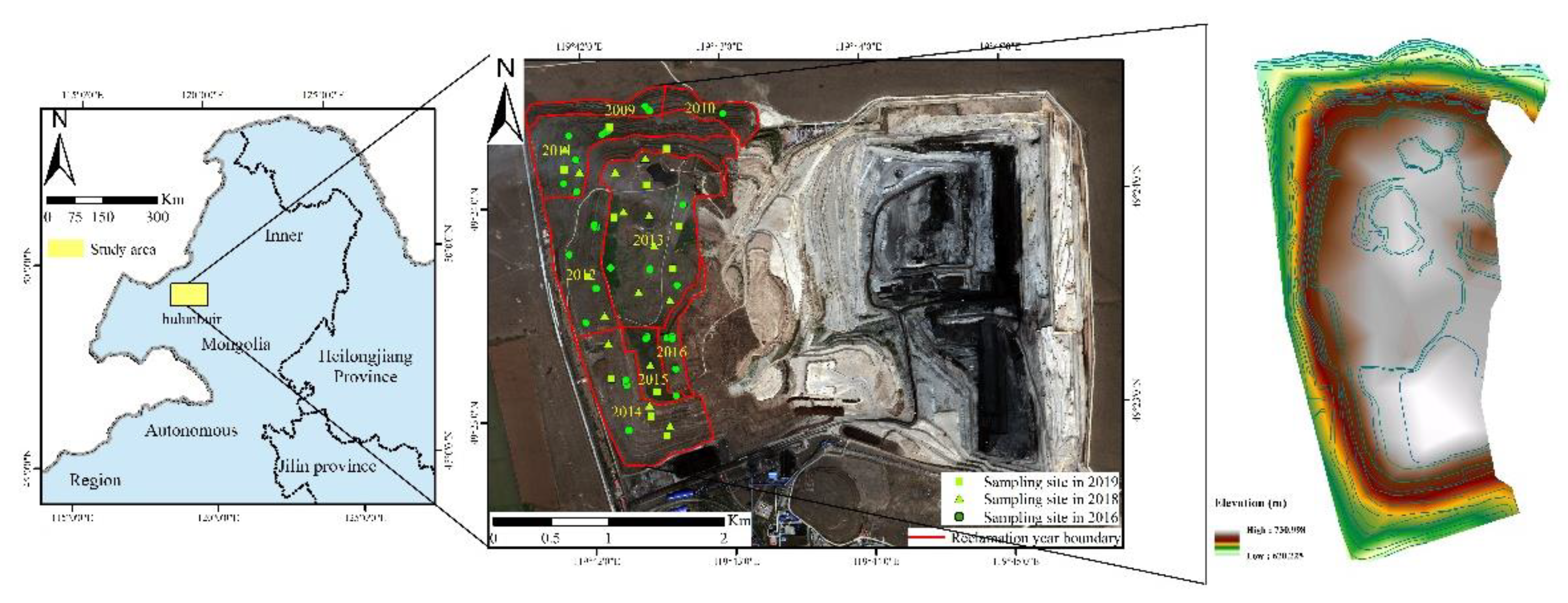
2.1. Field Study Location
2.2. Satellite Data Collection
2.3. Image Preprocessing
2.3.1. Synthetic Aperture Radar Image Preprocessing
2.3.2. SAR Image Reconstruction
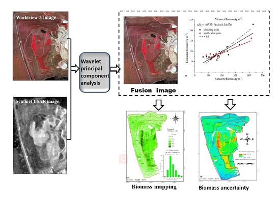
2.3.3. Image Fusion
2.3.4. Feature Parameter Extraction
2.4. Biomass Estimation Methods
3. Results
3.1. Image Reconstruction and Fusion
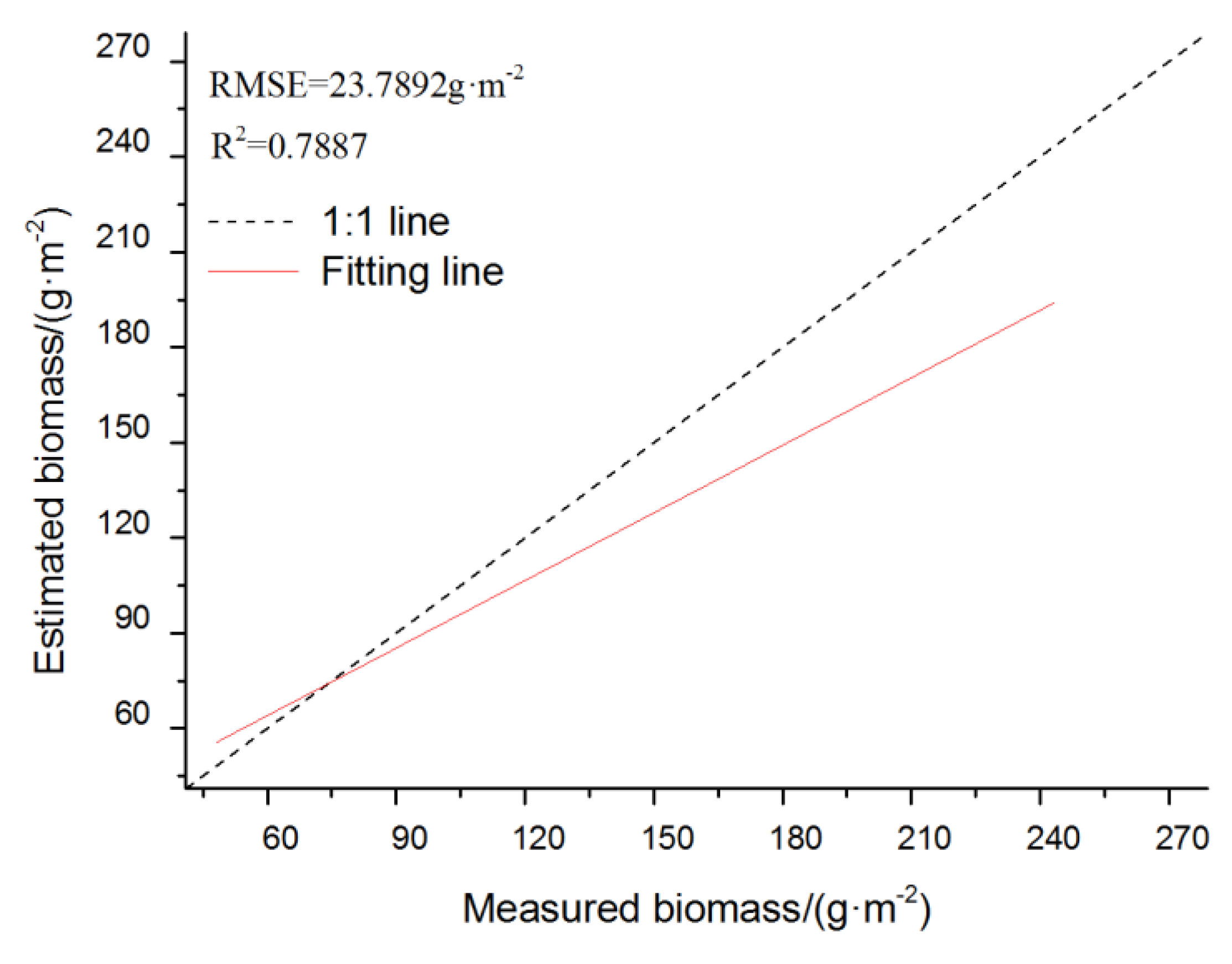
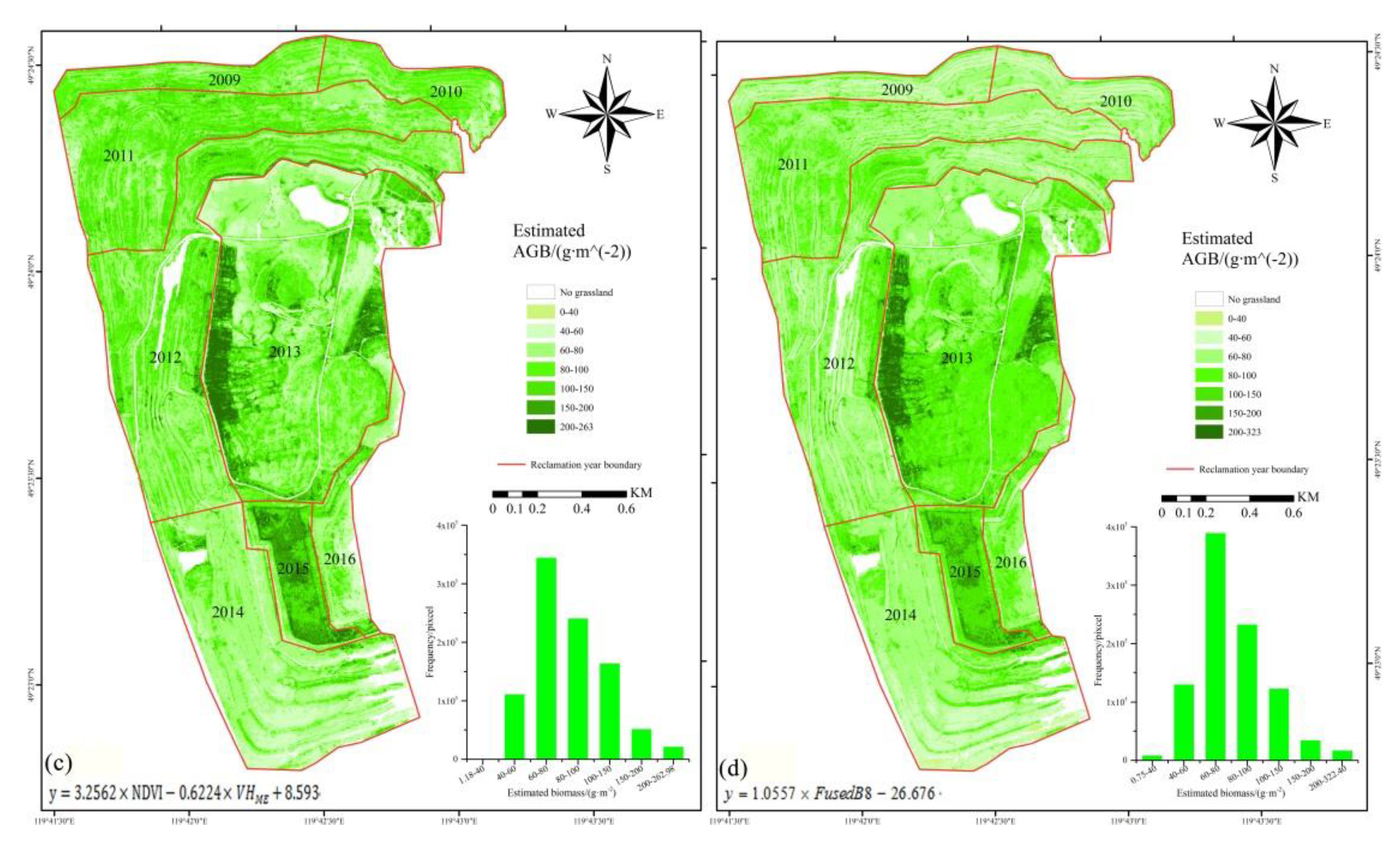
3.2. Above Ground Biomass (AGB)AGB Estimation Models and Uncertainty
4. Discussion
4.1. Relationship of the Measured AGB with Remote Sensing Variables
4.2. The Accuracy and Uncertainty of the AGB Estimation Model
5. Conclusions
- High correlation values between biomass and remote-sensing data were obtained from the fused-image band 8 (0.874), EVI (0.876), VH polarization (0.504), and the mean texture parameter of band 7 (0.760) at a 0.01 significance level.
- The developed regression model based on the fused-image band 8 input provides a higher accuracy in biomass estimation compared to models using Worldview-3 or SAR data alone, which have prediction errors of 22.82 g m−2 and 24.29 g m−2, and accuracies of 74.64% and 73.12%, respectively.
- Higher values of uncertainty were found in the reclamation areas of 2013 and 2015 with an average AGB of over 100 g m−2. The combination of the WV-3 and Sentinel-1 SAR data can reduce the uncertainty of the mean value from the saturation level by a decrement of 2.42 g m−2 to eventually become 9.68 g m−2.
Author Contributions
Acknowledgments
Conflicts of Interest
References
- Lv, X.; ** impervious surface. Remote Sens. Appl. Soc. Environ. 2019, 15, 100246. [Google Scholar] [CrossRef]
- Fu, B.; Wang, Y.; Campbell, A.; Li, Y.; Zhang, B.; Yin, S.; ** using high spatial resolution GF-1 and SAR data. Ecol. Indic. 2017, 73, 105–117. [Google Scholar]
- Gitelson, A.A.; Kaufman, Y.J.; Merzlyak, M.N. Use of a green channel in remote sensing of global vegetation from EOS-MODIS. Remote Sens. Environ. 1996, 58, 289–298. [Google Scholar] [CrossRef]
- Kaufman, Y.J.; Tanre, D. Atmospherically resistant vegetation index (ARVI) for EOS-MODIS. IEEE Trans. Geosci. Remote Sens. 1992, 30, 261–270. [Google Scholar] [CrossRef]
- Liu, H.Q.; Huete, A. A feedback based modification of the NDVI to minimize canopy background and atmospheric noise. IEEE Trans. Geosci. Remote Sens. 1995, 33, 457–465. [Google Scholar] [CrossRef]
- Sims, D.A.; Gamon, J.A. Relationships between leaf pigment content and spectral reflectance across a wide range of species, leaf structures and developmental stages. Remote Sens Environ. 2002, 81, 337–354. [Google Scholar] [CrossRef]
- Wang, D.; Wan, B.; Qiu, P.; Su, Y.; Wu, X. Evaluating the Performance of Sentinel-2, Landsat 8 and Pléiades-1 in Map** Mangrove Extent and Species. Remote Sens. 2018, 10, 1468. [Google Scholar] [CrossRef]
- Sidike, P.; Sagan, V.; Maimaitijiang, M.; Maimaitiyiming, M.; Shakoor, N.; Burken, J.; Mockler, T.; Fritschi, F.B. dPEN: Deep Progressively Expanded Network for map** heterogeneous agricultural landscape using WorldView-3 satellite imagery. Remote Sens. Environ. 2019, 221, 756–772. [Google Scholar] [CrossRef]
- Marshall, V.; Lewis, M.; Ostendorf, B. Do additional bands (Coastal, NIR-2, Red-Edge and Yellow) in worldview-2 multispectral imagery improve discrimination of an invasive Tussock, Buffel Grass (Cenchrus Ciliaris)? In Proceedings of the International Archives of the Photogrammetry, Remote Sensing and Spatial Information Science, Melbourne, Australia, 25 August–1 September 2012. [Google Scholar]
- Liu, L.; Wang, J.; Huang, W.; Zhao, C.; Zhang, B.; Tong, Q. Estimating winter wheat plant water content using red edge parameters. Int. J. Remote Sens. 2004, 25, 3331–3342. [Google Scholar] [CrossRef]
- Dong, T.; Liu, J.; Shang, J.; Qian, B.; Ma, B.; Kovacs, J.M.; Walters, D.; Jiao, X.; Geng, X.; Shi, Y. Assessment of red-edge vegetation indices for crop leaf area index estimation. Remote Sens. Environ. 2019, 222, 133–143. [Google Scholar] [CrossRef]
- Maimaitijiang, M.; Ghulam, A.; Sidike, P.; Hartling, S.; Maimaitiyiming, M.; Peterson, K.; Shavers, E.; Fishman, J.; Peterson, J.; Kadam, S.; et al. Unmanned Aerial System (UAS)-based phenoty** of soybean using multi-sensor data fusion and extreme learning machine. ISPRS J. Photogramm. Remote Sens. 2017, 134, 43–58. [Google Scholar] [CrossRef]
- Schultz, M.; Clevers, J.G.P.W.; Carter, S.; Verbesselt, J.; Avitabile, V.; Quang, H.V.; Herold, M. Performance of vegetation indices from Landsat time series in deforestation monitoring. Int. J. Appl. Earth Obs. Geoinf. 2016, 52, 318–327. [Google Scholar] [CrossRef]
- Kumar, V.; Sharma, A.; Bhardwaj, R.; Thukral, A.K. Comparison of different reflectance indices for vegetation analysis using Landsat-TM data. Remote Sens. Appl. Soc. Environ. 2018, 12, 70–77. [Google Scholar] [CrossRef]
- Barati, S.; Rayegani, B.; Saati, M.; Sharifi, A.; Nasri, M. Comparison the accuracies of different spectral indices for estimation of vegetation cover fraction in sparse vegetated areas. Egypt. J. Remote Sens. Space Sci. 2011, 14, 49–56. [Google Scholar] [CrossRef]
- Wood, E.M.; Pidgeon, A.M.; Radeloff, V.C.; Keuler, N.S. Image texture as a remotely sensed measure of vegetation structure. Remote Sens. Environ. 2012, 121, 516–526. [Google Scholar] [CrossRef]
- Hlatshwayo, S.T.; Mutanga, O.; Lottering, R.T.; Kiala, Z.; Ismail, R. Map** forest aboveground biomass in the reforested Buffelsdraai landfill site using texture combinations computed from SPOT-6 pan-sharpened imagery. Int. J. Appl. Earth Obs. Geoinf. 2019, 74, 65–77. [Google Scholar] [CrossRef]
- Fan, W.; Chao, W.; Hong, Z.; Bo, Z.; Tang, Y. Rice crop monitoring in South China with RADARSAT-2 quad-polarization SAR data. IEEE Geosci. Remote Sens. Lett. 2011, 8, 196–200. [Google Scholar]
- Liu, Y.; Gong, W.; ** Above-Ground Biomass by Integrating Optical and SAR Imagery: A Case Study of **+Above-Ground+Biomass+by+Integrating+Optical+and+SAR+Imagery:+A+Case+Study+of+** biomass of a northern forest using multifrequency SAR data. Geosci. Remote Sens. IEEE Trans. 1994, 32, 388–396. [Google Scholar] [CrossRef]


| Reclamation Year | Vegetation Cover | Dominant Species | Number of Sampling Sites | ||
|---|---|---|---|---|---|
| 2016 | 2018 | 2019 | |||
| 2009 | 50% | Elymus dahuricus Turcz. | 3 | 0 | 0 |
| Heteropappus altaicus (Willd.) Novopokr. | |||||
| 2010 | 50% | Elymus dahuricus Turcz. | 2 | 0 | 0 |
| 2011 | 60% | Elymus dahuricus Turcz. | 6 | 2 | 1 |
| Artemisia sieversiana | |||||
| 2012 | 62% | Artemisia sieversiana | 6 | 1 | 2 |
| Scutellaria baicalensis Georgi | |||||
| Bupleurum chinensis DC. | |||||
| 2013 | 70% | Medicago falcata L. | 4 | 4 | 4 |
| 2014 | 57% | Elymus dahuricus Turcz. | 4 | 3 | 3 |
| 2015 | 75% | Medicago falcata L. | 3 | 1 | 2 |
| 2016 | 50% | Elymus dahuricus Turcz. | 4 | 1 | 2 |
| Sensor | Spatial Resolution | Band Name | Wavelength (nm) |
|---|---|---|---|
| Coastline | 400–450 | ||
| Blue | 450–510 | ||
| Green | 510–580 | ||
| Worldview-3 | 1.24 m | Yellow | 585–625 |
| Red | 630–690 | ||
| Red edge | 705–745 | ||
| NIR1 | 770–895 | ||
| NIR2 | 860–1040 |
| Acquisition Time | Polarization Mode | Radiation Precision | Resolution |
|---|---|---|---|
| 29 July 2016 | VV+VH | 20 m (Azimuth resolution) | |
| 5 August 2016 | |||
| 10 August 2016 | 5 m (Range resolution) | ||
| 17 August 2016 |
| Vegetative Index | Calculation Formula | Advantages | Reference |
|---|---|---|---|
| NDVI | The most widely used vegetation index; the best indicator of vegetation growth and coverage. | Rouse et al., 1974 [20] | |
| DVI | Sensitive to changes in soil background, using areas with early- or mid-vegetation development or low-vegetation coverage. | Richardson and Weigand, 1977 [21] | |
| RVI | Sensitive to lush, high-coverage vegetation, with high RVI values for green vegetation and low RVI values for nonvegetation. | Pearson and Miller, 1972 [22] | |
| NDGI | Tests different forms of vital vegetation. | Gitelson et al., 1996 [23] | |
| ARVI | Reduces the impact of the atmosphere on the vegetation index. | Kanfman and Tanre, 1992 [24] | |
| EVI | Weakens the influence of the soil background. | Liu and Huete, 1995 [25] | |
| An improved version of the NDVI index that is very sensitive to small changes in vegetation canopy, forest window fragments, and aging changes. | Sims et al., 2002 [26] |
| Worldview-3 | Sentinel-1 SAR | Fusion | |||||
|---|---|---|---|---|---|---|---|
| Spectral Information | Texture Information | Texture Information | Spectral Information | ||||
| Variable | Correlation | Variable | Correlation | Variable | Correlation | Variable | Correlation |
| Coastline (B1) | −0.323 | B4ME | −0.741 ** | VH | 0.504 ** | B1 | −0.759 ** |
| Blue (B2) | −0.474 * | B5ME | −0.792 ** | VV | 0.410 * | B2 | −0.806 ** |
| Green (B3) | −0.372 | B5CR | −0.358 * | VVME | 0.412 ** | B3 | −0.837 ** |
| Yellow (B4) | −0.620 ** | B6ME | 0.511 ** | VVVA | 0.174 | B4 | −0.834 ** |
| Red (B5) | −0.657 ** | B6CR | −0.412 * | VVHO | −0.238 | B5 | −0.800 ** |
| Red edge (B6) | 0.215 | B7ME | 0.760 ** | VVCO | 0.165 | B6 | 0.564 ** |
| NIR1 (B7) | 0.694 ** | B7VA | 0.700 ** | VVDI | 0.201 | B7 | 0.842 ** |
| NIR2 (B8) | 0.718 ** | B7HO | −0.593 ** | VVEN | 0.257 | B8 | 0.874 ** |
| RVI | 0.790 ** | B7DI | 0.535 * | VVSM | −0.219 | ||
| NGVI | 0.871 ** | B7EN | 0.510 ** | VVCR | 0.169 | ||
| NDVI705 | 0.835 ** | B7SM | −0.366 * | VHME | 0.503 ** | ||
| NDVI | 0.874 ** | B8ME | 0.748 ** | VHVA | −0.061 | ||
| EVI | 0.876 ** | B8VA | 0.669 ** | VHHO | 0.069 | ||
| DVI | 0.833 ** | B8HO | −0.600 ** | VHCO | 0.064 | ||
| B8DI | 0.558 ** | VHDI | −0.016 | ||||
| B8EN | 0.612 ** | VHEN | −0.133 | ||||
| B8SM | 0.520 ** | VHSM | 0.298 | ||||
| VHCR | −0.195 | ||||||
| Label | Variable | Model | Model Accuracy (n = 11) | ||
|---|---|---|---|---|---|
| R2 | RMSE g m−2 | Ac% | |||
| a | EVI | y = 2.8408×EVI + 16.829 | 0.7098 | 24.2018 | 73.12 |
| b | VH | y = 2.2726×VH2 + 96.275×VH + 1094.4 | 0.3240 | 42.1104 | 53.22 |
| c | NDVI VHME | y = 3.2563×NDVI – 0.6224×VHME + 8.593 | 0.6963 | 23.6801 | 73.69 |
| d | FusedB8 | y = 1.0557×Fusion B8 – 26.676 | 0.7983 | 22.8283 | 74.64 |
© 2019 by the authors. Licensee MDPI, Basel, Switzerland. This article is an open access article distributed under the terms and conditions of the Creative Commons Attribution (CC BY) license (http://creativecommons.org/licenses/by/4.0/).
Share and Cite
Bao, N.; Li, W.; Gu, X.; Liu, Y. Biomass Estimation for Semiarid Vegetation and Mine Rehabilitation Using Worldview-3 and Sentinel-1 SAR Imagery. Remote Sens. 2019, 11, 2855. https://doi.org/10.3390/rs11232855
Bao N, Li W, Gu X, Liu Y. Biomass Estimation for Semiarid Vegetation and Mine Rehabilitation Using Worldview-3 and Sentinel-1 SAR Imagery. Remote Sensing. 2019; 11(23):2855. https://doi.org/10.3390/rs11232855
Chicago/Turabian StyleBao, Nisha, Wenwen Li, **aowei Gu, and Yanhui Liu. 2019. "Biomass Estimation for Semiarid Vegetation and Mine Rehabilitation Using Worldview-3 and Sentinel-1 SAR Imagery" Remote Sensing 11, no. 23: 2855. https://doi.org/10.3390/rs11232855