Letter

Discharge Estimation Using Harmonized Landsat and Sentinel-2 Product: Case Studies in the Murray Darling Basin

1
Shaanxi Key Laboratory of Earth Surface System and Environmental Carrying Capacity, Northwest University, **’an 710127, China
2
College of Urban and Environmental Sciences, Northwest University, **’an 710127, China
3
CSIRO Land and Water, Canberra, ACT 2600, Australia
4
Institute of Earth Surface System and Hazards, Northwest University, **’an 710127, China
*
Author to whom correspondence should be addressed.
Remote Sens. 2020, 12(17), 2810; https://doi.org/10.3390/rs12172810
Submission received: 23 June 2020 / Revised: 22 August 2020 / Accepted: 26 August 2020 / Published: 30 August 2020
(This article belongs to the Special Issue Remote Sensing for Streamflow Simulation)

Abstract

:
Quantifying river discharge is a critical component for hydrological studies, floodplain ecological conservation research, and water resources management. In recent years, a series of remote sensing-based discharge estimation methods have been developed. An example is the use of the near infrared (NIR) band of optical satellite images, with the principle of calculating the ratio between a stable land pixel for calibration (C) and a pixel within the river for measurement (M), applying a linear regression between C/M series and observed discharge series. This study trialed the C/M method, utilizing the Harmonized Landsat and Sentinel-2 (HLS) surface reflectance product on relatively small rivers with 30~100 m widths. Two study sites with different river characteristics and geographic settings in the Murray-Darling Basin (MDB) of Australia were selected as case studies. Two independent sets of HLS data and gauged discharge data for the 2017 and 2018 water years were acquired for modeling and validation, respectively. Results reveal high consistency between the HLS-derived discharge and gauged discharge at both sites. The Relative Root Mean Square Errors are 53% and 19%, and the Nash-Sutcliffe Efficiency coefficients are 0.24 and 0.69 for the two sites. This study supports the effectiveness of applying the fine-resolution HLS for modeling discharge on small rivers based on the C/M methodology, which also provides evidence of using multisource synthesized datasets as the input for discharge estimation.

Graphical Abstract

1. Introduction

Quantifying river discharge is essential for both scientific and operational applications for water resources management [1]. Historically, river discharge estimation has relied on having a network of in situ gauge stations to measure river levels. Data from the stations are then transferred to a central collection point, usually through some automated transfer system. Establishment of networks is expensive and requires maintenance, and indeed there are many rivers in the world which are not gauged. This shortage in global discharge data can be partially compensated for by the use of remote sensing [2]. Relevant research both in theory and practice is continually promoting methods and applications of discharge estimation regionally and globally [3,4,5].
There are three broad categories of methods for discharge estimation using remote sensing data [6]. The first category correlates remotely sensed water levels or inundation areas acquired at or near a gauge station with simultaneously collected ground data. Discharge is calculated using a site-specific stage-discharge relationship—this method is generally known as the rating curve method (see Reference [7] for an example). The second category uses physically based hydrological or hydraulic modeling based on river topographic information. Remotely sensed river width or water level is often used as an input parameter or as a reference for model calibration (see Reference [8] for an example). Methods in these two categories can be difficult to operate due to complex model computation and/or shortage of input data, such as river bathymetry information. The third category is remote sensing-driven methods that use remotely sensed data as major inputs to estimate discharge based on simple hydraulic geometry in the river channels [9,10,11,12,13]. The upcoming Surface Water and Ocean Topography (SWOT) satellite mission is expected to provide a great innovation into this category, due to its ability to directly measure surface water slope, effective river width, and water level [3]. Until now, many pre-SWOT studies have been conducted for discharge estimation, some using airborne calibration and validation instruments for SWOT (AirSWOT) [4], and others applying multi-source remote sensing data (including altimetry data in particular) to synthesize SWOT-type observations [14,15,16]. Another type of method in the third category is the C/M method developed by Brakenridge et al. [17] that takes advantage of the correlation between river discharge and surface water extent dynamics. While these dynamics can be easily captured by many conventional sensors, this C/M method has the advantage of low data requirements. Its original principle is calculating the ratio between a stable land pixel for calibration (C) and a pixel within river for measurement (M), then applying a linear regression between C/M series and observed discharge series to give discharge information at a site. There are mainly two kinds of the C/M method, one is to use optical satellite data, such as using the near infrared (NIR) band of Moderate Resolution Imaging Spectroradiometer (MODIS), which was first implemented by the authors of Reference [17]. The other is to use microwave satellite data, such as using Advanced Microwave Scanning Radiometer for the Earth Observing System (AMSR-E) data [18], later published as the Global Flood Detection System (GFDS) (http://www.gdacs.org/flooddetection/overview.aspx) for discharge estimation and flood detection, even for those ungauged and inaccessible rivers [19,20]. However, even though the microwave data has the advantage of higher temporal resolution without cloud obstruction, the way of conducting C/M by AMSR-E and GFDS is experiencing a more complex process and requiring other ancillary data, like a precipitation dataset, at the same time. While using optical data, the NIR band is the only required input for the C/M method, which is easily available. Tarpanelli et al. [21] further implemented this method and successfully estimated discharge for four reaches of the Po River in northern Italy based on carefully selected M and C pixels from MODIS NIR images. They then applied this method to the Niger-Benue River in 2017 [22] and achieved reasonable accuracy. Hou et al. [23] successfully tested the C/M method, using both MODIS and GFDS data, to monitor discharge across the Amazon Basin.
Due to the coarse spatial resolution, MODIS is generally used in large rivers with a width of more than 100 m. However, discharge estimation for smaller rivers with 30~100 m widths is also important, because these rivers are usually ungauged but broadly exist in arid and semi-arid river basins. The feasibility of using finer resolution data, such as Landsat data, for estimating discharge of relatively smaller rivers using the C/M method has been proven recently [24]. While taking advantage of high spatial resolution from Landsat, the disadvantage is that the discharge estimation frequency (i.e., temporal resolution) is low due to the 16-day revisit period of Landsat satellites. Following the launch of the two Sentinel-2 satellites in 2015 and 2017, the potential for the synergistic use of Landsat and Sentinel-2 data creates unprecedented opportunities for a frequent (less than 3 days) and accurate observation of Earth status and dynamics. A new Harmonized Landsat and Sentinel-2 (HLS) product was thus developed with the necessary radiometric and geometric corrections, resampling to provide surface reflectance of Landsat-8 and Sentinel-2 at 30 m resolution which are “stackable” [25]. This product has been widely used for various applications, including land monitoring [26], dryland ecosystem monitoring [27], crop intensity map** [28], and crop water balance monitoring [29]. This study, therefore, aims to testify the feasibility of applying the fine-resolution HLS for modeling discharge on selected small rivers based on the C/M methodology. Meanwhile, validation is carried out to show the performance of modeling, and to evaluate the discharge estimation while using this high spatial resolution and high temporal resolution synthesized dataset as the input.

2. Materials and Methods
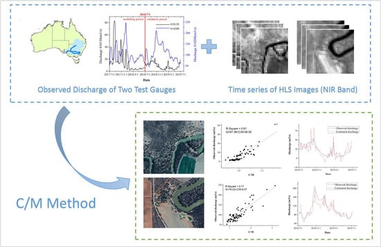
2.1. Materials

2.1.1. Study Area

The Murray-Darling Basin (MDB) in southeastern Australia is considered to be the most important and only fully developed water system in Australia. Most of the basin is relatively flat with long, slow rivers, which exhibit significant variations in annual flow [30]. In this study, hydrological Gauge 410130 in the Murrumbidgee River and Gauge 414200 in the Murray River and their surrounding areas were selected as the two test sites (Figure 1) for discharge estimation. The Murrumbidgee is a significant sub-basin of the Murray-Darling system and flows into the Murray, which flows down through the southern states of Australia to its exit to the sea. Approximate river widths at the gauge locations were measured on Google Earth, 60 m for 410130 and 90 m for 414200. Both sites have significant surrounding vegetation, including some farm-land, grass-land, and forests. No flow regulation structures were observed near the gauge locations.

2.1.2. Input Data

Discharge and remote sensing data were acquired for the study. The discharge data covering the 2017 water year (1 July 2017 to 30 June 2018) and the 2018 water year (1 July 2018 to 30 June 2019) were used as the modeling and validation periods, respectively. Observed daily discharge data (obtained in megaliters/day (ML/day) and converted to cubic meters/second (m3/s)) were acquired from the New South Wales Office of Water (http://realtimedata.water.nsw.gov.au/) (for Gauge 410130 in the Murrumbidgee site) and the Victorian Department of Environment and Primary Industries (http://data.water.vic.gov.au/) (for Gauge 414200 in the Murray site) (Figure 2).
Landsat 8 Operational Land Imager (OLI) is the latest sensor of Landsat missions and is one of the most popular sources of satellite data [31]. Sentinel-2 Multi Spectral Instrument (MSI) is another advanced data source with two sensors (2A/2B) working together. Combining Landsat and Sentinel-2 MSI creates a denser time series (less than 3 days, theoretically) which has been processed and made available as the Harmonized Landsat and Sentinel-2 (HLS) surface reflectance product [25], published on https://hls.gsfc.nasa.gov/. The HLS products obtain seamless products from both sensors (OLI and MSI) using a set of algorithms that include atmospheric correction, cloud and cloud-shadow masking, spatial co-registration and common gridding, bidirectional reflectance distribution function normalization, and spectral bandpass adjustment. Readers are referred to the user’s guide [32] for details of HLS processing. Corresponding bands between Harmonized Landsat-8 and Sentinel-2 are shown in Table 1. As Sentinel-2 of HLS was resampled from 10 to 30 m, band 5 of Landsat-8 and band 8A of Sentinel-2 were used as the input image series of the C/M method. All available images in the 2017 modeling and 2018 validation water years were acquired, and images that are cloud-free on the study sites (about 65%) were retained after visual inspection. Finally, for both sites, 80 images were used for modeling, and 72 images for validation, indicating an average revisit interval of approximately 5 days.

2.2. Methodology

A flowchart detailing the used inputs and methods in this study is shown in Figure 3. It mainly contains two parts, discharge modeling and result validation. Discharge modeling applies a linear regression between input NIR image series in the 2017 (modeling) water year and corresponding gauge observations to construct the empirical model. Result validation computes the bias between the observed and estimated discharge in the 2018 (validation) water year.

2.2.1. Discharge Modeling

The principle of discharge modeling using the C/M method is to take advantage of the ratio of reflectance from the NIR band between one stable land pixel (the calibration (C) pixel) and one pixel within the river (the measurement (M) pixel), and establish a relationship between the ratio (C/M) and the observed river discharge, which is then utilized for estimating discharge of another observation period based on remote sensing data. In this study, the C pixel was revised to be the average value of multiple land pixels in order to increase the stability of C observations. M remains to be the reflectance of a single pixel that best reflects in-channel water variation. To improve the efficiency of computation, C and M were selected inside a region of interest (ROI) that is within a certain distance to the gauge. A distance of 450 m was determined after trailing, which makes the ROI for both sites to be a rectangle of 31 × 31 pixels.
The input data include the observed discharge and quality-checked HLS product of the 2017 water year. To select the stable land pixels, a coefficient of variation (CV) was applied to each pixel, with CV defined as the ratio of the standard deviation to the mean computed through the HLS images in the 2017 water year. The CV value indicates the variability of surface reflectance [33], with lower CV representing more stable land cover in the pixel. Here, pixels with CV values lower than the 5th percentile (which represent relatively high stability) were chosen and averaged as the C pixel of each image [22]. Finding an optimal M pixel was more difficult. All pixels in the ROI were considered as M candidates at first. For each M candidate, a time series of C/M was calculated, whose correlation with observed discharge was quantified by Pearson’s correlation coefficient, r, and tested with the corresponding p-value. Finally, the pixel with the highest r value and a p-value < 0.05 (correlation is significant at the 95% confidence level) was chosen to be the optimal location of M. A linear function was then fitted between the final C/M series and observed discharge for each test site, which was then served as the discharge model for this specific site. For detailed information about the C/M method, readers are referred to Tarpanelli et al. [22].

2.2.2. Result Validation

Based on the established discharge estimation model, the HLS product for the 2018 water year was further employed as the input to estimate discharge for that year, which was then compared with the observed discharge for accuracy evaluation. Locations of C and M pixels determined in the modeling process were adopted directly for calculating the C/M time series for the 2018 water year. This C/M time series was then input into the fitted linear model to estimate discharge series. Using observed discharge corresponding to the remote sensing observations in water year 2018 as the reference, the performance of discharge estimation was evaluated by Root Mean Square Error (RMSE) (Equation (1)), Relative RMSE (RRMSE) (Equation (2)), and Nash-Sutcliffe Efficiency coefficient (NSE) (Equation (3)). RMSE represents the general prediction error. RRMSE represents the RMSE value normalized by the observed discharge, which indicates higher modeling accuracy with a lower value [34]. NSE is widely used in hydrological modeling, with a value closer to 1 indicating a more stable and reliable model [35]. In these equations, Q rs and Q g are remotely sensed estimated discharge and corresponding observed discharge, respectively. Q g ¯ represents the average value of observed discharge. Q g t and Q rs t are observed and remotely sensed estimated discharge at time t, respectively.
RMSE   =   [ t = 1 n ( Q rs     Q g ) 2 n ]
RRMSE   =   RMSE Q g ¯   ×   100 %
NSE   =   1     t = 1 T ( Q g t     Q rs t ) 2 t = 1 T ( Q g t     Q g ¯ ) 2

3. Results

3.1. Discharge Modeling Results

Locations of multiple C pixels were selected through CV images and are displayed as green circles in Figure 4a,b. The C series was computed through the method described in Section 2.2.1. Two images of Pearson’s correlation coefficient, r, were generated for these two sites in the 2017 water year (Figure 4c,d), together with the corresponding images of p-value (Figure 4e,f), which represent the significance level of correlation. Thus, the pixel with the highest r value at higher than 95% significance level (p < 0.05) was selected as the optimal M pixel for each site (marked as a red circle in Figure 4). Based on the final determined C and M pixels, time series of the C/M ratio were derived from the NIR band of the HLS product. Two linear functions were fitted between the C/M ratio series and observed discharge series for the 2017 water year in both sites (Figure 5). It is obvious that both sites have significant linear correlation with coefficients of determination (R2) equal to 0.81 for Murrumbidgee Gauge 410130 and 0.77 for Murray Gauge 414200.

3.2. Validation

To further validate the discharge model and evaluate the accuracy, another independent set of HLS data and observed discharge acquired in the 2018 water year were employed. In order to maintain the stability and improve the applicability of the discharge estimation model, the C and M locations determined for the 2017 dataset were adopted directly for the 2018 dataset, to generate the C/M series at each site. These series were then input into the fitted linear models to estimate discharge, and finally, an estimated discharge series for the 2018 water year was derived, shown together with the observed discharge in Figure 6.
An overall consistency was identified for the estimated and observed discharge series at both sites. For Gauge 410130, whose discharge is relatively small, the estimated series sometimes exaggerates the flow peak, for up to 10 m3/s. Abnormal negative discharge may be produced sometimes when the actual discharge is also very small. During a low flow period, the model tends to underestimate the discharge. For Gauge 414200, whose base flow is much higher, the estimated discharge series also got the shape of observed discharge series quite well. For the biggest flow peak event, which occurred in November 2018, the model successfully reflects the rapid increment of river discharge, although it is still a little bit underestimated. To further quantify the accuracy of estimated discharge series, three accuracy indices (RMSE, RRMSE, and NSE) were calculated, with the results reported in Table 2. Gauge 414200 has a RMSE significantly higher than Gauge 410130, which is mainly due to its much higher base flow. After normalizing by the base flow, RRMSE therefore represents a relatively unbiased evaluation on the accuracy. It is obvious that Gauge 414200 has a higher accuracy with RRMSE equaling to 19%, which suggests a good accuracy. The NSE index also suggests that Gauge 414200 has a much higher accuracy than Gauge 410130.

4. Discussion

The results based on the use of a Harmonized Landsat and Sentinel-2 product in this study suggest that blending multisource NIR bands from different sensors is feasible for discharge estimation by the C/M method. Through involving more remote sensing data sources, it may be possible to achieve daily discharge estimation for most of the relatively smaller rivers all over the world. Although the major restriction of the C/M method is that a series of observed discharge data are required to construct the regression model, this limitation can be alleviated by mounting automatic flow recording devices to collect discharge observation data for a period, as it seems that a relatively short period of observation can help establish a reliable estimation model. Our study demonstrates that a regression model established for a single water year is able to generate proper discharge estimation for another independent year, which suggests a possible extended application with the caveat that the surrounding vegetation does not change much. In addition, based on the theory of hydrological analogy [36], basins are hydrologically similar if they have similar geographical conditions, climate, and water sources. The river discharge characteristic of a gauged basin can be applied to estimate the discharge of a hydrologically similar ungauged basin. Based on this theory, Li et al. [24] presented a similarity coefficient of multiplying basin area and multiyear average precipitation, which was then combined with the C/M model at a gauged basin to obtain discharge estimation at its hydrologically similar basin. This confirms the applicability of the C/M method in ungauged basins, as long as a gauged hydrologically similar basin exists.
This study supports the effectiveness of discharge estimation by the C/M method for small rivers applying the HLS product. However, there are cases where the method may not be applicable. Firstly, it was suggested by this study that using a 30 m resolution HLS product to estimate discharge is more suitable for relatively wider river sections with higher base flow, which may lead to an issue of comparing spatial resolution of images and river extent. Thus, when the river is too small, remote sensing data and methods may need improvement. Secondly, resampling the NIR band of Sentinel-2 from 10 to 30 m may weaken the sensitivity in river discharge modeling through generalizing the remote sensing information. Furthermore, optical images are easily contaminated by clouds and their shadows, which further decreases the number of available HLS images. A possible solution for this is to integrate with microwave remote sensing data, such as Sentinel-1 Synthetic Aperture Radar (SAR) data, to eliminate weather effects. Thirdly, sediment content in river channels is likely to influence the model accuracy during flooding as the amount of sediment can be huge, changing the water reflectance significantly [37]. These above facts could detract from being able to capture more accurate and intense discharge variation during flooding events. Besides, it is noted that only two sites each with one year of record were tested in this study. The performances of discharge estimation using the C/M method may vary due to river morphological characteristics, such as river width, floodplain patterns, etc. [5]. More comprehensive studies are needed to further investigate how the C and M locations are affected by river morphological characteristics, which would then benefit the optimal selection of C and M pixels.

5. Conclusions

This study has demonstrated the feasibility of utilizing high spatial resolution and a high temporal resolution Harmonized Landsat and Sentinel-2 surface reflectance product to estimate river discharge for relatively small rivers with 30~100 m widths based on the C/M method. Two sites with different river characteristics and geographic settings in the MDB of Australia were selected for the study. It was found that for Gauge 410130 at Murrumbidgee River, where the river width is about 60 m, the RMSE, RRMSE, and NSE of the modeled discharge were 4.61 m3/s, 53%, and 0.24 respectively, indicating a moderate accuracy. Overestimation happened when estimating flow peaks. For Gauge 414200 at Murray River, whose river width is about 90 m, the modeled accuracy was significantly higher, with RMSE, RRMSE, and NSE of 20.87 m3/s, 19%, and 0.69, respectively. Low RRMSE and high NSE values indicate that the HLS-based C/M method works much better on a wider river with larger base flow. The study results are encouraging and sufficient to continue investment in advancing the C/M method, and in the meantime, filling the gap of estimating discharge for relatively smaller rivers by replacing coarse resolution MODIS data with higher resolution HLS data. Since the HLS product has the advantages of both high spatial and temporal resolution, our study provides a detailed investigation regarding the applicability of this product, and results support its application in the field of river discharge estimation. We are in an era of multi-source data explosion, and it is anticipated that many new synthesized products (such as the HLS) will be developed. This study demonstrates the feasibility of using multisource synthesized data as input for discharge estimation. It is also noted that there is significant difference in the estimation accuracy at both sites, which may result from river width or floodplain-specific patterns [5]. Our future work is to quantitatively investigate how these parameters affect the discharge estimation accuracy using the C/M method. To achieve this, more study sites, and many other data sources, including some globally available river width products [38,39,40,41], are to be involved in the future.

Author Contributions

Conceptualization, Z.S. and C.H.; Data curation, Q.L.; Formal analysis, Z.S.; Funding acquisition, C.H.; Investigation, C.H.; Methodology, Z.S., Y.C., and C.H.; Project administration, C.H.; Resources, Y.C.; Software, Z.S. and Q.L.; Supervision, C.H.; Validation, Z.S.; Visualization, Z.S.; Writing—original draft, Z.S. and C.H.; Writing—review and editing, Y.C. All authors have read and agreed to the published version of the manuscript.

Funding

This research was funded by the National Natural Science Foundation of China, grant number 41501460, and China Postdoctoral Science Foundation, grant number 2016M600808.

Acknowledgments

The work was undertaken while Zhuolin Shi was visiting CSIRO Land and Water under supervision of Susan Cuddy. We acknowledge the New South Wales Office of Water and Victorian Department of Environment and Primary Industries for providing gauge discharge data. Great thanks to NASA for providing the Harmonized Landsat and Sentinel-2 (HLS) surface reflectance dataset. We are grateful to Susan Cuddy of CSIRO for her careful review of this manuscript. We would like to thank Tarpanelli for hel** us understand the C/M algorithm. We thank the anonymous reviewers for their helpful comments.

Conflicts of Interest

The authors declare no conflict of interest. The funders had no role in the design of the study; in the collection, analyses, or interpretation of data; in the writing of the manuscript, or in the decision to publish the results.

References

  1. Palmer, M.; Ruhi, A. Measuring earth’s rivers. Science 2018, 361, 546–547. [Google Scholar] [CrossRef]
  2. The Ad Hoc Group; Vörösmarty, C.; Askew, A.; Grabs, W.; Barry, R.G.; Birkett, C.; Doll, P.; Goodison, B.; Hall, A.; Jenne, R.; et al. Global water data: A newly endangered species. Eos 2001, 82, 54. [Google Scholar] [CrossRef]
  3. Biancamaria, S.; Lettenmaier, D.P.; Pavelsky, T.M. The SWOT mission and its capabilities for land hydrology. Surv. Geophys. 2016, 37, 307–337. [Google Scholar] [CrossRef] [Green Version]
  4. Pavelsky, T.M.; Lind, G.; Overstreet, B.T.; Mangano, J.; Fonstad, M.; Hagemann, M.; Frasson, R.P.D.M.; Larnier, K.; Garambois, P.-A.; Monnier, J.; et al. Estimating River Discharge with Swath Altimetry: A Proof of Concept Using AirSWOT Observations. Geophys. Res. Lett. 2019, 46, 1459–1466. [Google Scholar] [CrossRef]
  5. Hou, J.; Van Dijk, A.I.; Beck, H.E. Global satellite-based river gauging and the influence of river morphology on its application. Remote Sens. Environ. 2020, 239, 111629. [Google Scholar] [CrossRef]
  6. Huang, C.; Chen, Y.; Zhang, S.; Wu, J. Detecting, Extracting, and Monitoring Surface Water From Space Using Optical Sensors: A Review. Rev. Geophys. 2018, 56, 333–360. [Google Scholar] [CrossRef]
  7. Smith, L.C.; Isacks, B.L.; Forster, R.R.; Bloom, A.L.; Preuss, I. Estimation of discharge from braided glacial rivers using ERS-1 Synthetic—Aperture Radar—First results. Water Resour. Res. 1995, 31, 1325–1329. [Google Scholar] [CrossRef]
  8. Bjerklie, D.M.; Moller, D.; Smith, L.C.; Dingman, S.L. Estimating discharge in rivers using remotely sensed hydraulic information. J. Hydrol. 2005, 309, 191–209. [Google Scholar] [CrossRef]
  9. Huang, Q.; Long, D.; Du, M.; Zeng, C.; Qiao, G.; Li, X.; Hou, A.; Hong, Y. Discharge estimation in high-mountain regions with improved methods using multisource remote sensing: A case study of the Upper Brahmaputra River. Remote Sens. Environ. 2018, 219, 115–134. [Google Scholar] [CrossRef]
  10. Sichangi, A.; Wang, L.; Yang, K.; Chen, D.; Wang, Z.; Li, X.; Zhou, J.; Liu, W.; Kuria, D. Estimating continental river basin discharges using multiple remote sensing data sets. Remote Sens. Environ. 2016, 179, 36–53. [Google Scholar] [CrossRef] [Green Version]
  11. Gleason, C.J.; Smith, L.C. Toward global map** of river discharge using satellite images and at-many-stations hydraulic geometry. Proc. Natl. Acad. Sci. USA 2014, 111, 4788–4791. [Google Scholar] [CrossRef] [PubMed] [Green Version]
  12. Yang, S.; Wang, P.; Lou, H.; Wang, J.; Zhao, C.; Gong, T. Estimating River Discharges in Ungauged Catchments Using the Slope–Area Method and Unmanned Aerial Vehicle. Water 2019, 11, 2361. [Google Scholar] [CrossRef] [Green Version]
  13. Brombacher, J.; Reiche, J.; Dijksma, R.; Teuling, A.J. Near-daily discharge estimation in high latitudes from Sentinel-1 and 2: A case study for the Icelandic Þjórsá river. Remote Sens. Environ. 2020, 241, 111684. [Google Scholar] [CrossRef]
  14. Oubanas, H.; Gejadze, I.; Malaterre, P.-O.; Mercier, F. River discharge estimation from synthetic SWOT-type observations using variational data assimilation and the full Saint-Venant hydraulic model. J. Hydrol. 2018, 559, 638–647. [Google Scholar] [CrossRef]
  15. Kim, D.; Yu, H.; Lee, H.; Beighley, E.; Durand, M.; Alsdorf, D.E.; Hwang, E. Ensemble learning regression for estimating river discharges using satellite altimetry data: Central Congo River as a Test-bed. Remote Sens. Environ. 2019, 221, 741–755. [Google Scholar] [CrossRef]
  16. Durand, M.; Gleason, C.J.; Garambois, P.A.; Bjerklie, D.; Smith, L.C.; Roux, H.; Rodriguez, E.; Bates, P.D.; Pavelsky, T.M.; Monnier, J.; et al. An intercomparison of remote sensing river discharge estimation algorithms from measurements of river height, width, and slope. Water Resour. Res. 2016, 52, 4527–4549. [Google Scholar] [CrossRef] [Green Version]
  17. Brakenridge, G.R.; Nghiem, S.; Anderson, E.; Chien, S. Space-based measurement of river runoff. Eos 2005, 86, 185. [Google Scholar] [CrossRef] [Green Version]
  18. Brakenridge, G.R.; Nghiem, S.; Anderson, E.; Mic, R.-P. Orbital microwave measurement of river discharge and ice status. Water Resour. Res. 2007, 43. [Google Scholar] [CrossRef]
  19. Khan, S.I.; Hong, Y.; Yong, B.; Khattak, M.U.; De Groeve, T. Multi-Sensor Imaging and Space-Ground Cross-Validation for 2010 Flood along Indus River, Pakistan. Remote Sens. 2014, 6, 2393–2407. [Google Scholar] [CrossRef] [Green Version]
  20. Kugler, Z.; De Groeve, T. The Global Flood Detection System; Scientific and Technical Reports; Joint Research Centre: Brussels, Belgium, 2007. [Google Scholar]
  21. Tarpanelli, A.; Brocca, L.; Lacava, T.; Melone, F.; Moramarco, T.; Faruolo, M.; Pergola, N.; Tramutoli, V. Toward the estimation of river discharge variations using MODIS data in ungauged basins. Remote Sens. Environ. 2013, 136, 47–55. [Google Scholar] [CrossRef]
  22. Tarpanelli, A.; Amarnath, G.; Brocca, L.; Massari, C.; Moramarco, T. Discharge estimation and forecasting by MODIS and altimetry data in Niger-Benue River. Remote Sens. Environ. 2017, 195, 96–106. [Google Scholar] [CrossRef]
  23. Hou, J.; Van Dijk, A.I.J.M.; Renzullo, L.J.; Vertessy, R.A. Using modelled discharge to develop satellite-based river gauging: A case study for the Amazon Basin. Hydrol. Earth Syst. Sci. 2018, 22, 6435–6448. [Google Scholar] [CrossRef] [Green Version]
  24. Li, H.; Li, H.; Wang, J.; Hao, X. Extending the Ability of Near-Infrared Images to Monitor Small River Discharge on the Northeastern Tibetan Plateau. Water Resour. Res. 2019, 55, 8404–8421. [Google Scholar] [CrossRef]
  25. Claverie, M.; Ju, J.; Masek, J.G.; Dungan, J.L.; Vermote, E.F.; Roger, J.-C.; Skakun, S.; Justice, C. The Harmonized Landsat and Sentinel-2 surface reflectance data set. Remote Sens. Environ. 2018, 219, 145–161. [Google Scholar] [CrossRef]
  26. Masek, J.; Ju, J.C.; Roger, J.C.; Skakun, S.; Claverie, M.; Dungan, J. Harmonized Landsat/Sentinel-2 products for land monitoring. In Proceedings of the IGARSS 2018: 2018 IEEE International Geoscience and Remote Sensing Symposium, Valencia, Spain, 22–27 July 2018. [Google Scholar] [CrossRef] [Green Version]
  27. Pastick, N.J.; Wylie, B.; Wu, Z. Spatiotemporal Analysis of Landsat-8 and Sentinel-2 Data to Support Monitoring of Dryland Ecosystems. Remote Sens. 2018, 10, 791. [Google Scholar] [CrossRef] [Green Version]
  28. Hao, P.; Tang, H.; Chen, Z.-X.; Yu, L.; Wu, M.-Q. High resolution crop intensity map** using harmonized Landsat-8 and Sentinel-2 data. J. Integr. Agric. 2019, 18, 2883–2897. [Google Scholar] [CrossRef]
  29. Gavilán, V.; Lillo-Saavedra, M.; Holzapfel, E.; Rivera, D.; García-Pedrero, A. Seasonal Crop Water Balance Using Harmonized Landsat-8 and Sentinel-2 Time Series Data. Water 2019, 11, 2236. [Google Scholar] [CrossRef] [Green Version]
  30. Docker, B.; Robinson, I. Environmental water management in Australia: Experience from the Murray-Darling Basin. Int. J. Water Resour. Dev. 2014, 30, 164–177. [Google Scholar] [CrossRef]
  31. Wu, Z.; Snyder, G.; Vadnais, C.; Arora, R.; Babcock, M.; Stensaas, G.; Doucette, P.; Newman, T. User needs for future Landsat missions. Remote Sens. Environ. 2019, 231, 111214. [Google Scholar] [CrossRef]
  32. Claverie, M.; Masek, J.G.; Ju, J.C.; Dungan, J.L. Harmonized Landsat-8 Sentinel-2 (HLS) Product User’s Guide; National Aeronautics and Space Administration (NASA): Washington, DC, USA, 2017.
  33. Brown, C.E. Coefficient of Variation. In Applied Multivariate Statistics in Geohydrology and Related Sciences; Springer: Berlin/Heidelberg, Germany, 1998; pp. 155–157. [Google Scholar] [CrossRef]
  34. Despotovic, M.; Nedic, V.; Despotović, D.; Cvetanovic, S. Evaluation of empirical models for predicting monthly mean horizontal diffuse solar radiation. Renew. Sustain. Energy Rev. 2016, 56, 246–260. [Google Scholar] [CrossRef]
  35. Nash, J.E.; Sutcliffe, J.V. River Flow forecasting through conceptual models-Part I: A discussion of principles. J. Hydrol. 1970, 10, 282–290. [Google Scholar] [CrossRef]
  36. Li, F.; Zhang, Y.; Xu, Z.; Liu, C.; Zhou, Y.; Liu, W. Runoff predictions in ungauged catchments in southeast Tibetan Plateau. J. Hydrol. 2014, 511, 28–38. [Google Scholar] [CrossRef]
  37. Guo, K.; Zou, T.; Jiang, D.-J.; Tang, C.; Zhang, H. Variability of Yellow River turbid plume detected with satellite remote sensing during water-sediment regulation. Cont. Shelf Res. 2017, 135, 74–85. [Google Scholar] [CrossRef]
  38. Andreadis, K.M.; Schumann, G.J.-P.; Pavelsky, T. A simple global river bankfull width and depth database. Water Resour. Res. 2013, 49, 7164–7168. [Google Scholar] [CrossRef]
  39. Yang, X.; Pavelsky, T.M.; Allen, G.; Donchyts, G. RivWidthCloud: An Automated Google Earth Engine Algorithm for River Width Extraction from Remotely Sensed Imagery. IEEE Geosci. Remote Sens. Lett. 2019, 17, 217–221. [Google Scholar] [CrossRef]
  40. Frasson, R.P.D.M.; Pavelsky, T.M.; Fonstad, M.A.; Durand, M.; Allen, G.; Schumann, G.J.-P.; Lion, C.; Beighley, R.E.; Yang, X. Global Relationships Between River Width, Slope, Catchment Area, Meander Wavelength, Sinuosity, and Discharge. Geophys. Res. Lett. 2019, 46, 3252–3262. [Google Scholar] [CrossRef] [Green Version]
  41. Isikdogan, F.; Bovik, A.C.; Passalacqua, P. RivaMap: An automated river analysis and map** engine. Remote Sens. Environ. 2017, 202, 88–97. [Google Scholar] [CrossRef]
Figure 1. Location and condition of study sites. Images are obtained from Google Earth acquired on 16 November 2018. Triangles show the gauge locations.
Remotesensing 12 02810 g001
Figure 2. Observed daily discharge at Gauges 410130 and 414200 for the 2017 and 2018 water years.
Remotesensing 12 02810 g002
Figure 3. Flowchart of methodology (C stands for Calibration pixel, M stands for Measurement pixel, and CV stands for Coefficient of Variation).
Remotesensing 12 02810 g003
Figure 4. (a) Coefficient of Variation (CV) for region of interest (ROI) of Gauge 410130, (b) CV for ROI of Gauge 414200, (c) Pearson’s r for ROI of Gauge 410130, (d) Pearson’s r for ROI of Gauge 414200, (e) Pearson’s p-value for ROI of Gauge 410130, (f) Pearson’s p-value for ROI of Gauge 414200. Green circles on (a,b) stand for locations of multiple calibration (c) pixels obtained from CV. Final C value of one image is average value of these multiple C pixels. Red circles on (cf) stand for the final locations of the single Measurement (M) pixel with the highest Pearson’s r. The triangles stand for locations of two gauges (red: 410130; pink: 414200).
Remotesensing 12 02810 g004
Figure 5. Correlation and scatter plot of the C/M ratio and observed discharge. (a) Gauge 410130, (b) Gauge 414200 (Q refers to estimated discharge based on the C/M method).
Remotesensing 12 02810 g005
Figure 6. Temporal pattern of C/M-based discharge and observed discharge in validation year. (a) Gauge 410130, (b) Gauge 414200.
Remotesensing 12 02810 g006
Table 1. Corresponding bands between Harmonized Landsat-8 and Sentinel-2.
Spectral Region NameLandsat 8 OLI* BandLandsat 8 OLI Wavelength (nm)Equivalent Sentinel-2 BandSentinel-2 Central Wavelength (nm)Spatial Resolution (m)
Coastal aerosol1433~453144330
Blue2450~515249030
Green3525~600356030
Red4630~680466530
NIR5845~8858A86530
SWIR 161560~166011161030
SWIR 272100~230012219030
*OLI: Operational Land Imager.
Table 2. Accuracy of discharge estimation for two test gauges in validation year.
Gauge IDRiver Width (m)Discharge Monitoring
RMSE* (m3/s)RRMSE (%)*NSE*
410130~604.61530.24
414200~9020.87190.69
*RMSE: Root Mean Square Error; RRMSE: Relative RMSE; NSE: Nash-Sutcliffe Efficiency coefficient.

