
Cotton Stand Counting from Unmanned Aerial System Imagery Using MobileNet and CenterNet Deep Learning Models


Abstract
:
1. Introduction
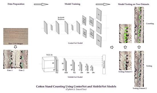
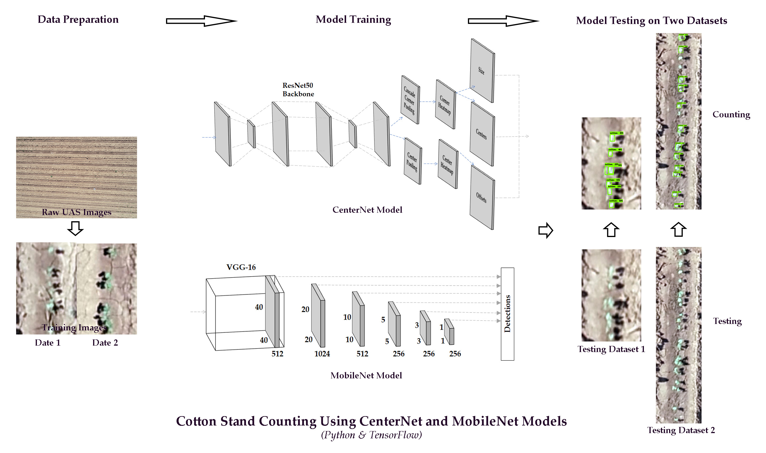
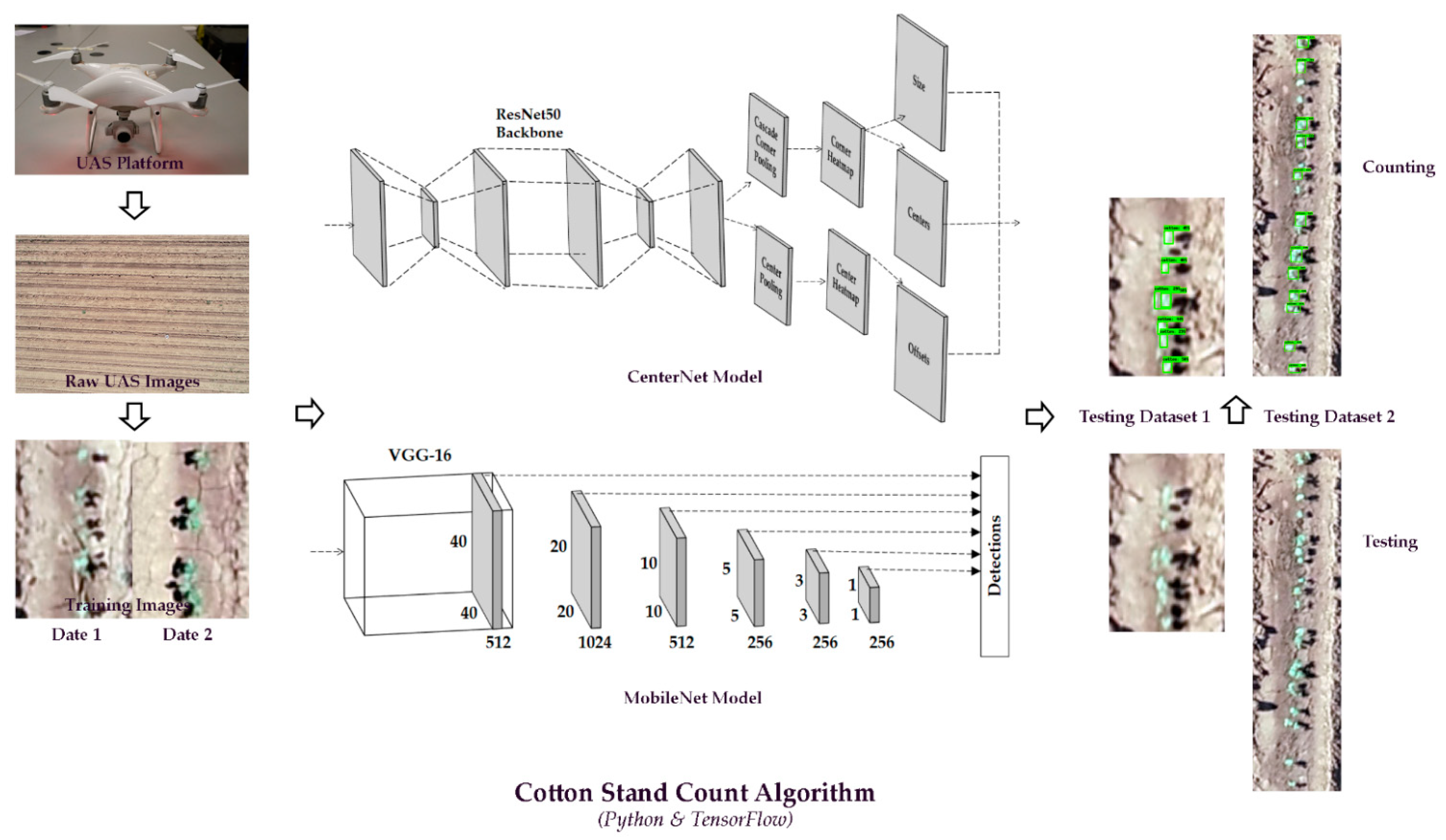
2. Materials and Methods
2.1. Experimental Sites
2.2. UAS Image Acquisition
2.3. Training and Testing Images
2.4. MobileNet
2.5. CenterNet
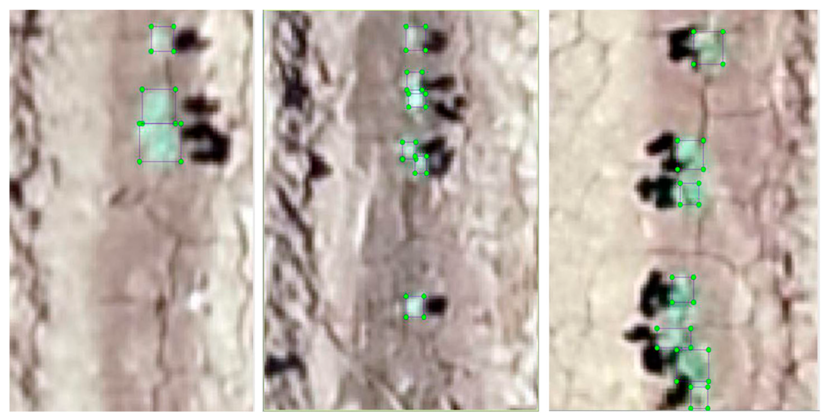
2.6. Counting and Evaluations
3. Results
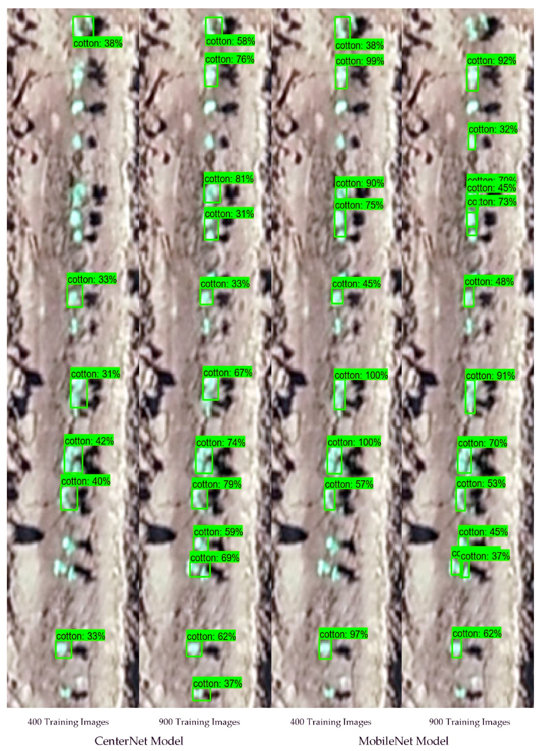
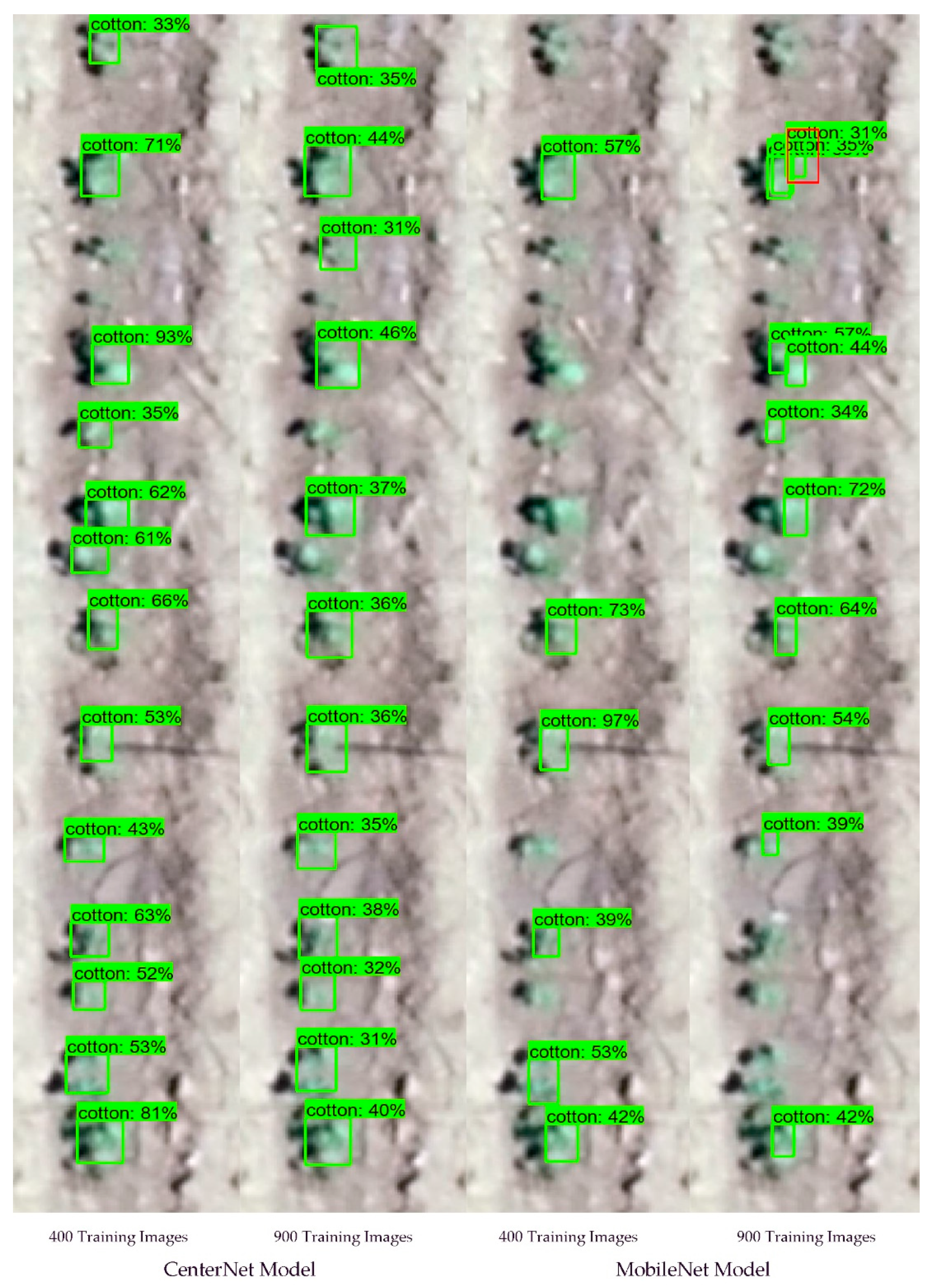
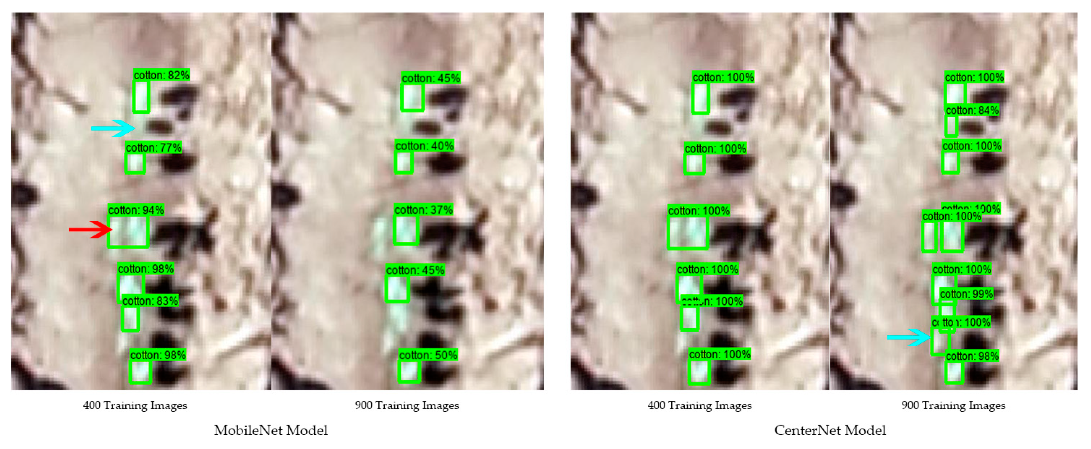
3.1. Model Validation
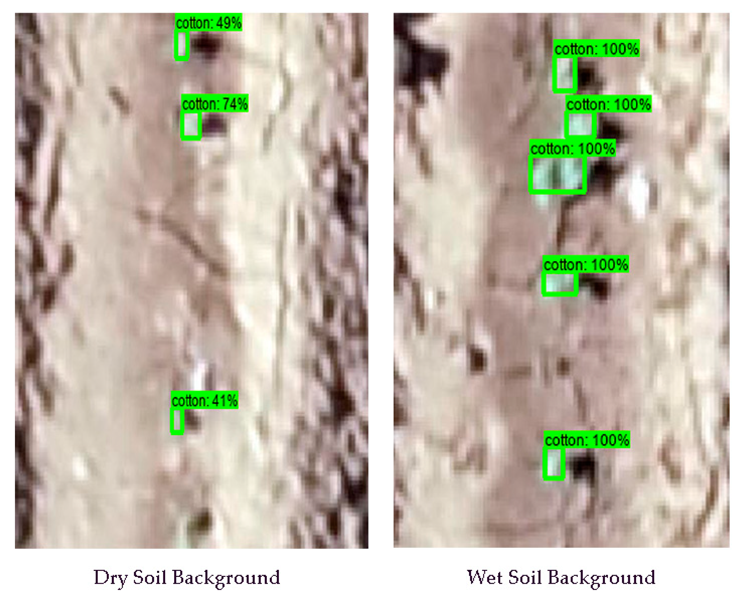
3.2. Model Evaluation in Stand Counting
4. Discussion
5. Conclusions
Author Contributions
Funding
Data Availability Statement
Acknowledgments
Conflicts of Interest
References
- Reddy, K.R.; Brand, D.; Wijewardana, C.; Gao, W. Temperature effects on cotton seedling emergence, growth, and development. Agron. J. 2017, 109, 1379–1387. [Google Scholar] [CrossRef]
- Zheng, S.L.; Wang, L.J.; Wan, N.X.; Zhong, L.; Zhou, S.M.; He, W.; Yuan, J.C. Response of potato tuber number and spatial distribution to plant density in different growing seasons in Southwest China. Front. Plant Sci. 2016, 7, 365. [Google Scholar] [CrossRef] [Green Version]
- Liu, T.; Wu, W.; Chen, W.; Sun, C.; Zhu, X.; Guo, W. Automated image-processing for counting seedlings in a wheat field. Precis. Agric. 2016, 17, 392–406. [Google Scholar] [CrossRef]
- Godfrey, L.D.; Goodell, P.B.; Natwick, E.T.; Haviland, D.R.; Barlow, V.M. UC IPM pest management guidelines: Cotton. Available online: http://ipm.ucanr.edu/PMG/r3300311.html (accessed on 16 November 2020).
- Benson, G.O. Making corn replant decisions. In Proceedings of the Beltwide Cotton Conference Proceedings, San Antonio, TX, USA, 3–5 January 2018; pp. 1–7. [Google Scholar]
- Hopper, N.W.; Supak, J. Fungicide treatment effects on cotton (Gossypium hirsutum) emergence, establishment and yield. Texas J. Agric. Nat. Resour. 1993, 6, 69–80. [Google Scholar]
- Sun, S.; Li, C.; Paterson, A.H.; Chee, P.W.; Robertson, J.S. Image processing algorithms for infield single cotton boll counting and yield prediction. Comput. Electron. Agric. 2019, 166, 104976. [Google Scholar] [CrossRef]
- Zhao, B.; Zhang, J.; Yang, C.; Zhou, G.; Ding, Y.; Shi, Y.; Zhang, D.; ** of soybean using multi-sensor data fusion and extreme learning machine. ISPRS J. Photogramm. Remote Sens. 2017, 134, 43–58. [Google Scholar] [CrossRef]
- Li, B.; Xu, X.; Han, J.; Zhang, L.; Bian, C.; **, L.; Liu, J. The estimation of crop emergence in potatoes by UAV RGB imagery. Plant Methods 2019, 15, 1–13. [Google Scholar] [CrossRef] [PubMed] [Green Version]
- Rasmussen, J.; Nielsen, J.; Streibig, J.C.; Jensen, J.E.; Pedersen, K.S.; Olsen, S.I. Pre-harvest weed map** of Cirsium arvense in wheat and barley with off-the-shelf UAVs. Precis. Agric. 2019, 20, 983–999. [Google Scholar] [CrossRef]
- Lee, U.; Chang, S.; Putra, G.A.; Kim, H.; Kim, D.H. An automated, high-throughput plant phenoty** system using machine learning-based plant segmentation and image analysis. PLoS ONE 2018, 13, e0196615. [Google Scholar] [CrossRef] [PubMed] [Green Version]


| Model | Number of Training Images | mAP (%) | AR (%) | F1-Score (%) |
|---|---|---|---|---|
| MobileNet | 400 | 67 | 39 | 63 |
| - | 900 | 86 | 72 | 81 |
| CenterNet | 400 | 71 | 48 | 75 |
| - | 900 | 79 | 73 | 87 |
| Model | Testing Dataset | Number of Training Images | R2 | RMSE | MAE | MAPE (%) |
|---|---|---|---|---|---|---|
| MobileNet | 1 | 400 | 0.86 | 0.89 | 0.54 | 0.26 |
| - | - | 900 | 0.96 | 0.64 | 0.33 | 0.11 |
| - | 2 | 400 | 0.48 | 7.81 | 7.48 | 7.83 |
| - | - | 900 | 0.87 | 3.66 | 6.22 | 5.61 |
| CenterNet | 1 | 400 | 0.89 | 0.58 | 0.25 | 0.10 |
| - | - | 900 | 0.98 | 0.37 | 0.27 | 0.07 |
| - | 2 | 400 | 0.60 | 6.08 | 8.03 | 6.57 |
| - | - | 900 | 0.86 | 3.94 | 5.39 | 4.73 |
Publisher’s Note: MDPI stays neutral with regard to jurisdictional claims in published maps and institutional affiliations. |
© 2021 by the authors. Licensee MDPI, Basel, Switzerland. This article is an open access article distributed under the terms and conditions of the Creative Commons Attribution (CC BY) license (https://creativecommons.org/licenses/by/4.0/).
Share and Cite
Lin, Z.; Guo, W. Cotton Stand Counting from Unmanned Aerial System Imagery Using MobileNet and CenterNet Deep Learning Models. Remote Sens. 2021, 13, 2822. https://doi.org/10.3390/rs13142822
Lin Z, Guo W. Cotton Stand Counting from Unmanned Aerial System Imagery Using MobileNet and CenterNet Deep Learning Models. Remote Sensing. 2021; 13(14):2822. https://doi.org/10.3390/rs13142822
Chicago/Turabian StyleLin, Zhe, and Wenxuan Guo. 2021. "Cotton Stand Counting from Unmanned Aerial System Imagery Using MobileNet and CenterNet Deep Learning Models" Remote Sensing 13, no. 14: 2822. https://doi.org/10.3390/rs13142822