
A Novel Framework for Rapid Detection of Damaged Buildings Using Pre-Event LiDAR Data and Shadow Change Information


Abstract
:
1. Introduction
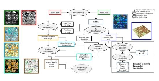
2. Methodologies
2.1. Generation of Baseline Building Digital Surface Models (DSMs)
2.2. Shadow Simulation
2.3. Building Damage Simulation
2.4. Building Shadow Differencing
2.5. Shadow Change Detectability
3. Results
3.1. Case A—Based on Simulated Building DSM
3.2. Case B—Analyses Using LiDAR-Based Building DSM
3.2.1. Comparison of Pleiades and Predicted Baseline Shadows
3.2.2. Shadow Changes from Simulated Building Damage
4. Conclusions and Discussion
- Shadow differencing information is essential for the rapid detection of damaged buildings that are not in total collapse.
- There is a limitation on the detection of building height changes based on the estimation of the shadow length from remote sensing imagery. This limitation is dependent on the fineness of the optical image spatial resolution, from which the post-event shadow patterns are extracted, and also is influenced by the solar elevation angle.
- One key step in damage detection is the differencing of the baseline shadow patterns between the DSM-based and image-based shadow maps. The baseline shadow difference map is essential in the processing as reference information for the rapid detection of damaged buildings. The differences in the baseline shadow maps result from several causes, such as errors in shadow extraction from imagery, the low quality of LiDAR data, and the lack of building DSM updating. The baseline shadow difference map information can be used for the validation of the building damage detection using the shadow change information and also for improvement of the baseline building DSM map information for response preparation.
- A high level of similarity of the baseline building DSM map with reality before the event is essential for building damage detection using the building shadow change information. Meanwhile, since the gap between the building DSM replica and the building morphology in reality is not avoidable, the information about the differences between the shadow maps from a LiDAR-based baseline surface model and from extraction from the image before the event are important information layers for the improvement of the detection accuracy.
Author Contributions
Funding
Institutional Review Board Statement
Informed Consent Statement
Data Availability Statement
Acknowledgments
Conflicts of Interest
References
- Dong, L.; Shan, J. A comprehensive review of earthquake-induced building damage detection with remote sensing techniques. ISPRS J. Photogramm. Remote Sens. 2013, 84, 85–99. [Google Scholar] [CrossRef]
- Schweier, C.; Markus, M.; Steinle, E. Simulation of earthquake caused building damages for the development of fast reconnaissance techniques. Nat. Hazards Earth Syst. Sci. 2004, 4, 285–293. [Google Scholar] [CrossRef] [Green Version]
- Balsa-Barreiro, J. LiDAR for management in natural disasters and catastrophes. In Government Briefing Book: Emerging Technology & Human Rights; Greene, K.G., Ed.; Berkman Klein Center: Cambridge, MA, USA, 2019; Volume 1, p. 11. Available online: https://www.greenestrategy.com/brief (accessed on 1 July 2021).
- Tong, X.; Hong, Z.; Liu, S.; Zhang, X.; ** of high-rise buildings in urban areas based on combined shadow analysis and scale space processing. Int. J. Remote Sens. 2014, 35, 3616–3630. [Google Scholar] [CrossRef] [Green Version]
- Bensaibi, M.; Saadi, S.; Bouder, A. Automatic detection of seismic damages from very high monoscopic spatial images. Asian J. Civ. Eng. 2020, 21, 1039–1050. [Google Scholar] [CrossRef]
- Vu, T.T.; Matsuoka, M.; Yamazaki, F. Shadow Analysis in Assisting in Damage Detection Due to Earthquakes from Quickbird Imagery. Available online: https://www.semanticscholar.org/paper/SHADOW-ANALYSIS-IN-ASSISTING-DAMAGE-DETECTION-DUE-Vu-Matsuoka/73c1273c029fefb055b58656fc07391d3be1e6e8 (accessed on 1 July 2021).
- Liu, C.; Sui, H.; Huang, L. Identification of Damaged Building Regions from High-Resolution Images Using Superpixel-Based Gradient and Autocorrelation Analysis. IEEE J. Sel. Top. Appl. Earth Obs. Remote Sens. 2020, 99. [Google Scholar] [CrossRef]
- Zhang, R.; Duan, K.; You, S.; Wang, F.; Tan, S. A novel remote sensing detection method for buildings damaged by earthquake based on multiscale adaptive multiple feature fusion. Geomat. Nat. Hazards Risk 2020, 11, 1912–1938. [Google Scholar] [CrossRef]
- Oludare, V.; Kezebou, L.; Panetta, K.; Agaian, S. Semi-supervised learning for improved post-disaster damage assessment from satellite imagery. SPIE Proc. 2021, 11734, 117340O. [Google Scholar] [CrossRef]
- Tong, X.; Lin, X.; Feng, T.; ** of damaged buildings through simulation and change detection of shadows using LiDAR and multispectral data. SPIE Remote Sens. Proc. 2019, 11157. [Google Scholar] [CrossRef]


| Damage Model | Damage Type Number (Schweier and Markus, [26]) | Type of Damage | Description of Damage | Usefulness of Shadow Information |
|---|---|---|---|---|
| Model 1 | 4, 4b, 4c, 5, 5a, 5b, 5c | Height Reduction | Reduction in height due to pancaked collapse, with undamaged (flat) roof. | Difficult to be detected in image without shadow information |
| Model 2 | 1, 2, 6, 7 | Height Reduction with damaged roof | Reduction in height due to pancaked collapse, roof totally or partly damaged, with changed shape of the building top. | Difficult to be detected in image without shadow information |
| Model 3 | 8, 9b | Overturn | Overturn collapse, parts are separated. | Easy to be detected directly in image. Shadow information can be helpful. |
| Model 4 | 9a | Leaning | Inclination of whole building with shifting roof from footprint | From difficult to easy to be detected directly in image without shadow information, depending on the inclination angle |
| Model 5 | 3, 7a, 7b | Total collapse | The building is totally collapsed and easy to be detected in image without using shadow information | Obvious in imagery. Easy to be detected directly in image without shadow information |
| Model 6 | 10 | Overhang element | Damage on parts of the building bottom. | Undetectable in imagery with or without shadow information |
Publisher’s Note: MDPI stays neutral with regard to jurisdictional claims in published maps and institutional affiliations. |
© 2021 by the authors. Licensee MDPI, Basel, Switzerland. This article is an open access article distributed under the terms and conditions of the Creative Commons Attribution (CC BY) license (https://creativecommons.org/licenses/by/4.0/).
Share and Cite
Zhang, Y.; Roffey, M.; Leblanc, S.G. A Novel Framework for Rapid Detection of Damaged Buildings Using Pre-Event LiDAR Data and Shadow Change Information. Remote Sens. 2021, 13, 3297. https://doi.org/10.3390/rs13163297
Zhang Y, Roffey M, Leblanc SG. A Novel Framework for Rapid Detection of Damaged Buildings Using Pre-Event LiDAR Data and Shadow Change Information. Remote Sensing. 2021; 13(16):3297. https://doi.org/10.3390/rs13163297
Chicago/Turabian StyleZhang, Ying, Matthew Roffey, and Sylvain G. Leblanc. 2021. "A Novel Framework for Rapid Detection of Damaged Buildings Using Pre-Event LiDAR Data and Shadow Change Information" Remote Sensing 13, no. 16: 3297. https://doi.org/10.3390/rs13163297