
Wind and Turbulence Statistics in the Urban Boundary Layer over a Mountain–Valley System in Granada, Spain

 , , and
Abstract
:
1. Introduction
2. Experimental Site and Instrumentation
3. Methodology
3.1. Halo Lidar Toolbox
- Background correction has been applied to the raw data with methods published by [62,63]. A correction for the telescope focus of the instrument was also applied to the signal, as explained in [60]. The instrumental precision of radial velocities was estimated with the method given by [27,70], and attenuated backscatter coefficient () with uncertainties were also calculated [64];
- From scanning measurements, three-dimensional wind vector profiles were calculated using the least squares method with singular value decomposition by assuming a stationary and horizontally homogeneous wind field, and radial velocity uncertainties were propagated to wind components as described by [65]. The wind component uncertainties were estimated with the method described by [66];
- The vertical velocity statistical momenta, i.e., variance, skewness, and kurtosis, were calculated from vertically pointing measurements at 3, 30, and 60 min resolutions. Statistics unbiased by random noise and sample size were calculated as given by [67] and standard errors were estimated with a bootstrap method described by [68];
- Wind shear vector, which can also be a source of turbulent mixing, is also calculated. This vector is calculated from the changes in and wind components with height [61], as:therefore, its module is:
- The dissipation rate of the turbulent kinetic energy, , was calculated from vertically pointing measurements using the method presented by [41]. This quantity was defined as the rate at which the turbulence energy is absorbed by breaking the eddies down into smaller eddies until they are ultimately converted into heat by viscous forces [71], following the Kolmogorov hypothesis [72]. The method applies Taylor’s frozen turbulence hypothesis that eddies travel with the mean wind while maintaining their characteristics [73]. This quantity is then used as an indicator of turbulent mixing, instead of the combination of vertical skewness and variance [14]. The method used also provides an uncertainty estimate for [41];
- Finally, all the previously calculated quantities were combined following a decision tree to create a bitfield-based classification mask. This method was created by [64] following the profile-based Doppler lidar method introduced by [52] with the aim of objectively assigning a dominant source for turbulent mixing. The analyzed regions of the profiles were selected from calibrated to height ranges with sufficient atmospheric signal and no clouds (a threshold 10 Mm−1 sr−1 was used based on the literature [14,52,74]). The presence of turbulence was obtained from with a threshold > 10−5 m2 s−3 or > 10−4 m2 s−3, depending whether the classified heights were below cloud or connected to the surface [64]. All range gates with surface-connected turbulent behavior during daytime were classified as dominated by convective mixing. During night-time, when ABL is assumed to be neutral or stably stratified [71], wind-shear derived turbulence is searched with a threshold > 0.03 s−1 [75]. Finally, range gates that are classified as turbulent but are unconnected to surface or clouds during daytime, and not related to wind shear during night-time, are labelled as ‘intermittent’ since turbulence is assumed to arise from other intermittent sources [76].
3.2. Data Processing
4. Results
4.1. Horizontal Wind Field Characterization
4.2. ABL Turbulent Sources Characterization
5. Conclusions
Author Contributions
Funding
Data Availability Statement
Acknowledgments
Conflicts of Interest
Appendix A. Weibull Parameters by Season

References
- IPCC. Summary for Policymakers. In Global Warming of 1.5 °C. An IPCC Special Report on the Impacts of Global Warming of 1.5 °C above Pre-Industrial Levels and Related Global Greenhouse Gas Emission Pathways, in the Context of Strengthening the Global Response to the Threat of Climate Change, Sustainable Development, and Efforts to Eradicate Poverty; Masson-Delmotte, V., Zhai, P., Pörtner, H.-O., Roberts, D., Skea, J., Shukla, P.R., Pirani, A., Moufouma-Okia, W., Péan, C., Pidcock, R., et al., Eds.; World Meteorological Organization: Geneva, Switzerland, 2018; 32p. [Google Scholar]
- Myhre, G.; Shindell, D.; Bréon, F.-M.; Collins, W.; Fuglestvedt, J.; Huang, J.; Koch, D.; Lamarque, J.-F.; Lee, D.; Mendoza, B.; et al. Anthropogenic and natural radiative forcing. In Climate Change 2013: The Physical Science Basis. Contribution of Working Group I to the Fifth Assessment Report of the Intergovernmental Panel on Climate Change; Stocker, T.F., Qin, D., Plattner, G.-K., Tignor, M., Allen, S.K., Boschung, J., Nauels, A., ** Methods for Doppler Lidar to Investigate Atmospheric Boundary Layer; University of Helsinki: Helsinki, Finland, 2019. [Google Scholar]
- Lothon, M.; Lohou, F.; Pino, D.; Couvreux, F.; Pardyjak, E.R.; Reuder, J.; Vilà-Guerau De Arellano, J.; Durand, P.; Hartogensis, O.; Legain, D.; et al. The BLLAST field experiment: Boundary-layer late afternoon and sunset turbulence. Atmos. Chem. Phys. 2014, 14, 931–960. [Google Scholar] [CrossRef] [Green Version]
- Granados-Muñoz, M.J.; Navas-Guzmán, F.; Bravo-Aranda, J.A.; Guerrero-Rascado, J.L.; Lyamani, H.; Fernández-Gálvez, J.; Alados-Arboledas, L. Automatic determination of the planetary boundary layer height using lidar: One-year analysis over southeastern Spain. J. Geophys. Res. Atmos. 2012, 117, D18208. [Google Scholar] [CrossRef] [Green Version]
- US-EPA (United States Environmental Protection Agency). Meteorological Monitoring Guidance for Regulatory Modeling Applications; Office of Air Quality Planning and Standards: Durham, NC, USA, 2000.
- Atmospheric Research and Technology LLC Vector vs. Scalar Averaging of Wind Data. Available online: http://www.sodar.com/FYI/vector_vs_scalar.html (accessed on 14 December 2020).
- Grange, S.K. Technical Note: Averaging Wind Speeds and Directions; University of Auckland: Auckland, New Zealand, 2014. [Google Scholar]
- Stull, R. Practical Meteorology: An Algebra-Based Survey of Atmospheric Science; University of British Columbia: Vancouver, BC, Canada, 2017; ISBN 978-0-88865-283-6. [Google Scholar]
- Jammalamadaka, S.R.; SenGupta, A. Topics in Circular Statistics; World Scientific: Singapore, 2001; ISBN 9789712779267. [Google Scholar]
- Jones, T.A. MATLAB functions to analyze directional (azimuthal) data-I: Single-sample inference. Comput. Geosci. 2006, 32, 166–175. [Google Scholar] [CrossRef]
- American Meteorological Society Glossary of Meteorology, 2nd ed.; American Meteorological Society: Boston, MA, USA, 2000.
- Blackadar, A.K. Boundary layer wind maxima and their significance for the growth of nocturnal inversions. Bull. Am. Meteorol. Soc. 1957, 38, 283–290. [Google Scholar] [CrossRef] [Green Version]
- Baars, H.; Ansmann, A.; Engelmann, R.; Althausen, D. Continuous monitoring of the boundary-layer top with lidar. Atmos. Chem. Phys. 2008, 8, 7281–7296. [Google Scholar] [CrossRef] [Green Version]


| Emission | |
| Wavelength | 1500 nm |
| Pulse energy | 100 µJ |
| Pulse duration | 200 ns |
| Pulse repetition rate | 15 kHz |
| Reception optics | |
| Telescope | monostatic optic-fiber coupled |
| Physical lens diameter | 75 mm |
| Effective beam diameter * | (17.5 ± 1) mm |
| Lens divergence | 33 µrad |
| Focal length * | (535 ± 35) m |
| Detection | |
| Detection type | Heterodyne |
| Range resolution | 30 m |
| Points per range bin | 10 |
| Sampling frequency | 50 MHz |
| Velocity resolution | 0.0382 m s−1 |
| Nyquist velocity | 20 m s−1 |
| DJF | MAM | JJA | SON | |
|---|---|---|---|---|
| ‘Day’ interval (h UTC) | 10–18 | 10–22 | 10–21 | 9–20 |
| ‘Night’ interval (h UTC) | 20–9 | 23–7 | 1–8 | 22–7 |
| Daytime | Night-Time | |||||
|---|---|---|---|---|---|---|
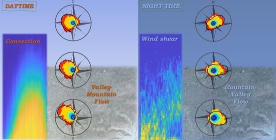
| Altitude a.g.l. (m) | 580–820 (Figure 5a) | 340–580 (Figure 5c) | 100–340 (Figure 5e) | 580–820 (Figure 5b) | 340–580 (Figure 5d) | 100–340 (Figure 5f) |
| 289.7 | 293.4 | 299.1 | 61.6 | 85.0 | 106.4 | |
| 1.0 | 1.4 | 2.0 | 2.1 | 6.3 | 5.0 | |
| 0.95 | 0.92 | 0.87 | 0.48 | 0.25 | 0.14 | |
| 213.8 | 205.8 | 205.3 | 233.3 | 0.0 | 91.5 | |
| 15.0 | 10.0 | 5.0 | 0.9 | 0.03 | 0.5 | |
| 0.05 | 0.08 | 0.13 | 0.52 | 0.75 | 0.86 | |
Publisher’s Note: MDPI stays neutral with regard to jurisdictional claims in published maps and institutional affiliations. |
© 2022 by the authors. Licensee MDPI, Basel, Switzerland. This article is an open access article distributed under the terms and conditions of the Creative Commons Attribution (CC BY) license (https://creativecommons.org/licenses/by/4.0/).
Share and Cite
Ortiz-Amezcua, P.; Martínez-Herrera, A.; Manninen, A.J.; Pentikäinen, P.P.; O’Connor, E.J.; Guerrero-Rascado, J.L.; Alados-Arboledas, L. Wind and Turbulence Statistics in the Urban Boundary Layer over a Mountain–Valley System in Granada, Spain. Remote Sens. 2022, 14, 2321. https://doi.org/10.3390/rs14102321
Ortiz-Amezcua P, Martínez-Herrera A, Manninen AJ, Pentikäinen PP, O’Connor EJ, Guerrero-Rascado JL, Alados-Arboledas L. Wind and Turbulence Statistics in the Urban Boundary Layer over a Mountain–Valley System in Granada, Spain. Remote Sensing. 2022; 14(10):2321. https://doi.org/10.3390/rs14102321
Chicago/Turabian StyleOrtiz-Amezcua, Pablo, Alodía Martínez-Herrera, Antti J. Manninen, Pyry P. Pentikäinen, Ewan J. O’Connor, Juan Luis Guerrero-Rascado, and Lucas Alados-Arboledas. 2022. "Wind and Turbulence Statistics in the Urban Boundary Layer over a Mountain–Valley System in Granada, Spain" Remote Sensing 14, no. 10: 2321. https://doi.org/10.3390/rs14102321