
“Cool” Roofs as a Heat-Mitigation Measure in Urban Heat Islands: A Comparative Analysis Using Sentinel 2 and Landsat Data


Abstract
:1. Introduction
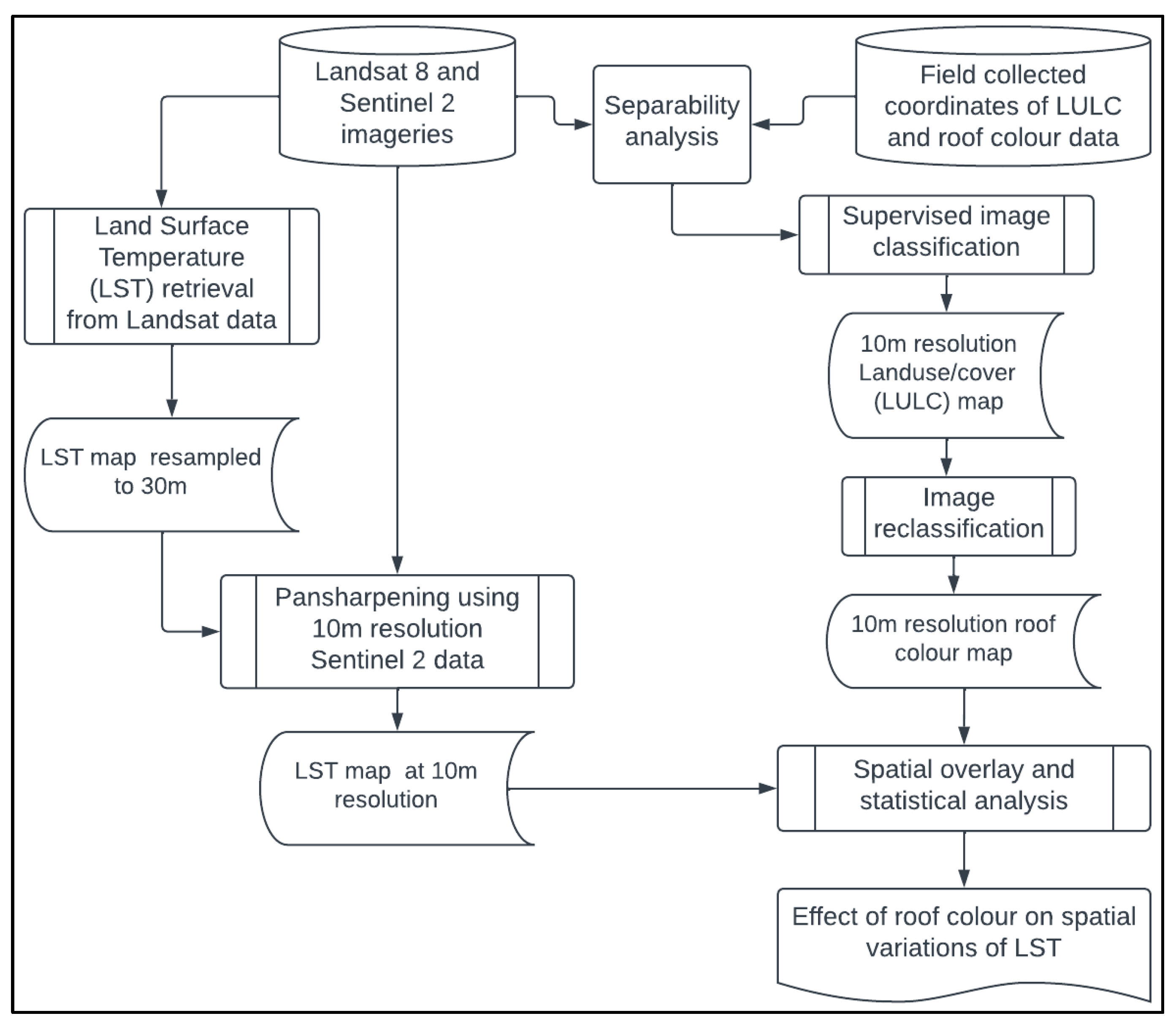
2. Methodology
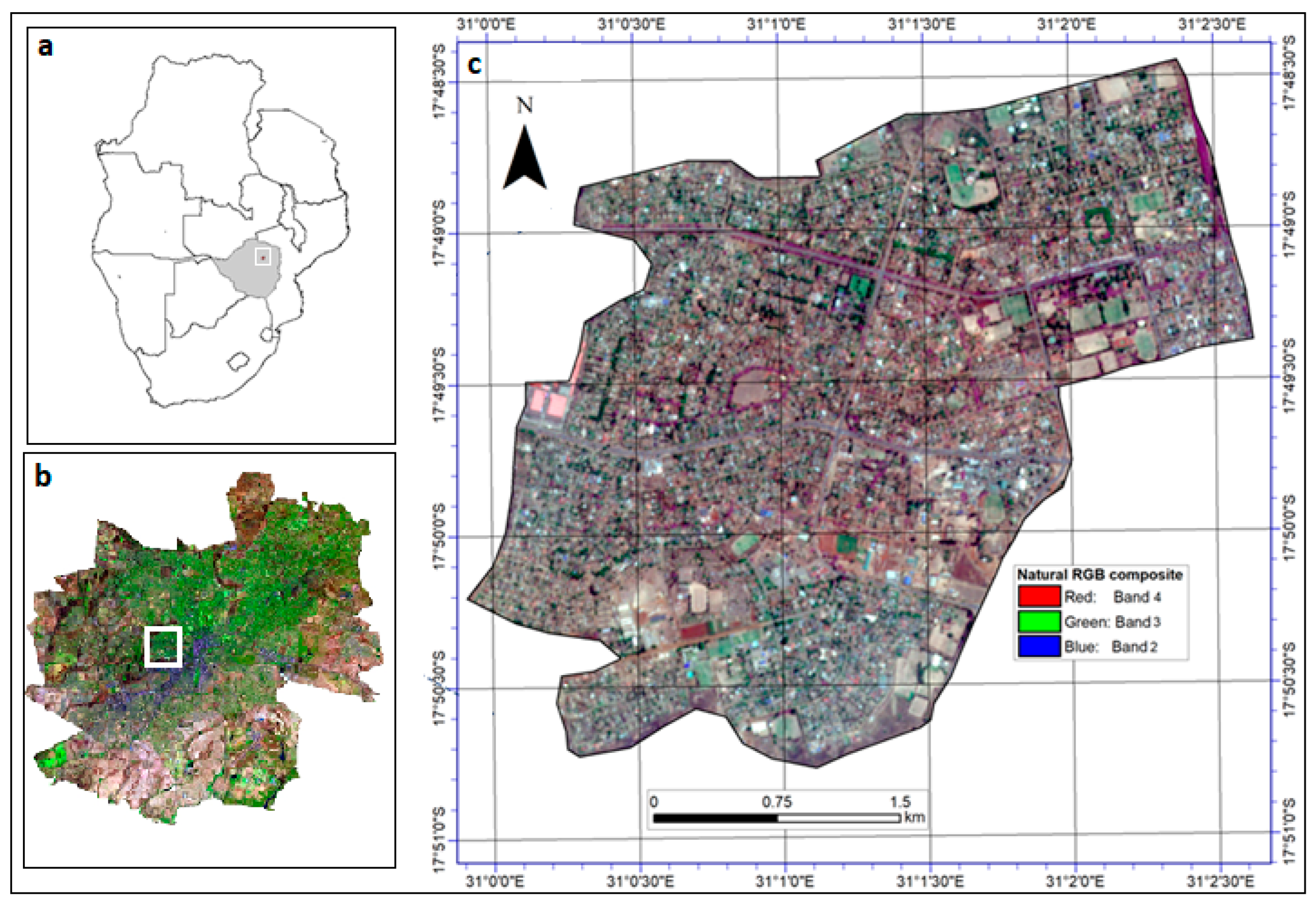
2.1. Description of the Study Area
2.2. Field and Remotely Sensed Datasets
2.3. Separability Analysis
2.4. Land Use/Cover Map** and Retrievals of Roof Colours
2.5. Land Surface Temperature Retrieval from Landsat 8 Data
2.6. Gram-Schmidt Pan-Sharpening Based Method for LST Image Data Pan-Sharpening
2.7. Intensity Analysis for In-Depth Characterization of Local Climate Zones Changes
2.8. Linking LULC Types and Roof Colours with LST
3. Results
3.1. Separability of LULC and Roofs by Colour
3.2. Land Use/Cover and Roof Colour Map** Using 10 M Resolution Sentinel 2 Data
3.3. Accuracy of LULC and Roof Colour Retrievals from Sentinel 2 Data
3.4. Comparison of 30 M Resolution with Sharpened 10 M Resolution LST Retrievals
3.5. Variations of LST with LULC and Roof Colours
4. Discussion
5. Conclusions
Author Contributions
Funding
Data Availability Statement
Acknowledgments
Conflicts of Interest
References
- Meinel, G.; Winkler, M. Long-term investigation of urban sprawl on the basis of remote sensing data-Results of an international city comparison. In Proceedings of the 24th EARSeL-Symposium, Paphos, Cyprus, 13–16 September 2022; Leibniz Institute of Ecological and Regional Development (IOER): Dresden, Germany, 2005. [Google Scholar]
- Aldwaik, S.Z.; Pontius, R.G., Jr. Landscape and Urban Planning Intensity analysis to unify measurements of size and stationarity of land changes by interval, category, and transition. Landsc. Urban Plan. 2012, 106, 103–114. [Google Scholar] [CrossRef]
- Hamin, E.M.; Gurran, N. Urban form and climate change: Balancing adaptation and mitigation in the U.S. and Australia. Habitat Int. 2009, 33, 238–245. [Google Scholar] [CrossRef]
- Odindi, J.O.; Bangamwabo, V.; Mutanga, O. Assessing the value of urban green spaces in mitigating multi-seasonal urban heat using MODIS land surface temperature (LST) and landsat 8 data. Int. J. Environ. Res. 2015, 9, 9–18. [Google Scholar] [CrossRef]
- Ngie, A.; Abutaleb, K.; Ahmed, F.; Taiwo, O.J.; Darwish, A.A.; Ahmed, M. An estimation of land surface temperatures from landsat ETM+ images for Durban, South Africa. Rwanda J. 2017, 1, 1–17. [Google Scholar] [CrossRef]
- Lee, L.; Chen, L.; Wang, X.; Zhao, J. Use of Landsat TM/ETM+ data to analyze urban heat island and its relationship with land use/cover change. In Proceedings of the 2011 International Conference on Remote Sensing, Environment and Transportation (RSETE) Engineering, Nan**g, China, 24–26 June 2011; pp. 922–927. [Google Scholar] [CrossRef]
- Pérez-Andreu, V.; Aparicio-Fernández, C.; Martínez-Ibernón, A.; Vivancos, J.L. Impact of climate change on heating and cooling energy demand in a residential building in a Mediterranean climate. Energy 2018, 165, 63–74. [Google Scholar] [CrossRef]
- Pantavou, K.; Theoharatos, G.; Mavrakis, A.; Santamouris, M. Evaluating thermal comfort conditions and health responses during an extremely hot summer in Athens. Build. Environ. 2011, 46, 339–344. [Google Scholar] [CrossRef]
- Mahdavi, A.; Kumar, S. Implications of indoor climate control for comfort, energy and environment. Energy Build. 1996, 24, 167–177. [Google Scholar] [CrossRef]
- Ormandy, D.; Ezratty, V. Thermal discomfort and health: Protecting the susceptible from excess cold and excess heat in housing. Adv. Build. Energy Res. 2016, 10, 84–98. [Google Scholar] [CrossRef]
- Parkinson, T.; de Dear, R. Thermal pleasure in built environments: Spatial alliesthesia from air movement. Build. Res. Inf. 2017, 45, 320–335. [Google Scholar] [CrossRef]
- Hecht, R.; Herold, H.; Meinel, G.; Buchroithner, M. Automatic Derivation of Urban Structure Types from Topographic Maps by Means of Image Analysis and Machine Learning. In Proceedings of the 26th International Cartographic Conference, Dresden, Germany, 25–30 August 2013; Volume 2013, p. 18. [Google Scholar]
- Ketterer, C.; Matzarakis, A. Comparison of different methods for the assessment of the urban heat island in Stuttgart, Germany. Int. J. Biometeorol. 2015, 59, 1299–1309. [Google Scholar] [CrossRef]
- Zhou, D.; ** urban surface characteristics for urban energy flux modelling. In Proceedings of the Map** Urban Areas from Space Conference, Frascati, Italy, 4–5 November 2015. [Google Scholar]
- Kaplan, G.; Avdan, U. Sentinel-2 Pan Sharpening—Comparative Analysis. Proceedings 2018, 2, 345. [Google Scholar] [CrossRef]
- Dhau, I.; Dube, T.; Mushore, T.D. Examining the prospects of sentinel-2 multispectral data in detecting and map** maize streak virus severity in smallholder Ofcolaco farms, South Africa. Geocarto Int. 2019, 36, 1873–1883. [Google Scholar] [CrossRef]
- Mushore, T.D.; Mutanga, O.; Odindi, J.; Sadza, V.; Dube, T. Pansharpened landsat 8 thermal-infrared data for improved Land Surface Temperature characterization in a heterogeneous urban landscape. Remote Sens. Appl. Soc. Environ. 2022, 26, 100728. [Google Scholar] [CrossRef]
- Shi, Y.; Lau, K.K.; Ren, C.; Ng, E. Urban Climate Evaluating the local climate zone classi fi cation in high-density heterogeneous urban environment using mobile measurement. Urban Clim. 2018, 25, 167–186. [Google Scholar] [CrossRef]
- Wilson, J.S.; Clay, M.; Martin, E.; Stuckey, D.; Vedder-Risch, K. Evaluating environmental influences of zoning in urban ecosystems with remote sensing. Remote Sens. Environ. 2003, 86, 303–321. [Google Scholar] [CrossRef]
- Zhou, X.; Wang, Y.C. Dynamics of Land Surface Temperature in Response to Land-Use/Cover Change. Geogr. Res. 2011, 49, 23–36. [Google Scholar] [CrossRef]
- Klok, L.; Zwart, S.; Verhagen, H.; Mauri, E. The surface heat island of Rotterdam and its relationship with urban surface characteristics. Resour. Conserv. Recycl. 2012, 64, 23–29. [Google Scholar] [CrossRef]
- Wang, X.; Dai, W.; Dai, J. Develo** Fine-scale Urban Canopy Parameters in Guangzhou City and its Application in the WRF-Urban model. World 2017, 9000, 10000. Available online: http://www.meteo.fr/icuc9/LongAbstracts/gd5-2-3221289_a.pdf (accessed on 4 July 2022).
- Mushore, T.D.; Dube, T.; Manjowe, M.; Gumindoga, W.; Chemura, A.; Rousta, I.; Odindi, J.; Mutanga, O. Remotely sensed retrieval of Local Climate Zones and their linkages to land surface temperature in Harare metropolitan city, Zimbabwe. Urban Clim. 2019, 27, 259–271. [Google Scholar] [CrossRef]
- Qiu, C.; Mou, L.; Schmitt, M.; **ang, X. Local climate zone-based urban land cover classification from multi-seasonal Sentinel-2 images with a recurrent residual network. ISPRS J. Photogramm. Remote Sens. 2019, 154, 151–162. [Google Scholar] [CrossRef]
- Mackey, C.W.; Lee, X.; Smith, R.B. Remotely sensing the cooling effects of city scale efforts to reduce urban heat island. Build. Environ. 2012, 49, 348–358. [Google Scholar] [CrossRef]
- Cai, M.; Ren, C.; Xu, Y. Investigating the relationship between Local Climate Zone and land surface temperature. In Proceedings of the 2017 Joint Urban Remote Sensing Event (JURSE), Dubai, United Arab Emirates, 6–8 March 2017; pp. 1–4. [Google Scholar] [CrossRef]
- Cilek, M.U.; Cilek, A. Analyses of land surface temperature (LST) variability among local climate zones (LCZs) comparing Landsat-8 and ENVI-met model data. Sustain. Cities Soc. 2021, 69, 102877. [Google Scholar] [CrossRef]
- Smith, K.R.; Roebber, P.J. Green roof mitigation potential for a proxy future climate scenario in Chicago, Illinois. J. Appl. Meteorol. Climatol. 2011, 50, 507–522. [Google Scholar] [CrossRef]
- Bass, B.; Baskaran, B. Evaluating Rooftop and Vertical Gardens as an Adaptation Strategy for Urban Areas. Natl. Res. Counc. Canada 2001, NRCC-46737, 111. Available online: http://www.nps.gov/tps/sustainability/greendocs/bass.pdf (accessed on 21 March 2022).
- Tian, Y.; Bai, X.; Qi, B.; Sun, L. Study on heat fluxes of green roofs based on an improved heat and mass transfer model. Energy Build. 2017, 152, 175–184. [Google Scholar] [CrossRef]
- Dominique, M.; Tiana, R.H.; Fanomezana, R.T.; Ludovic, A.A. Thermal behavior of green roof in Reunion Island: Contribution towards a net zero building. Energy Procedia 2014, 57, 1908–1921. [Google Scholar] [CrossRef]
- Granja, A.D.; Labaki, L.C. Influence of external surface colour on the periodic heat flow through a flat solid roof with variable thermal resistance. Int. J. Energy Res. 2003, 27, 771–779. [Google Scholar] [CrossRef]
- Farhan, S.A.; Ismail, F.I.; Kiwan, O.; Shafiq, N.; Zain-Ahmed, A.; Husna, N.; Hamid, A.I.A. Effect of roof tile colour on heat conduction transfer, roof-top surface temperature and cooling load in modern residential buildings under the tropical climate of Malaysia. Sustainability 2021, 13, 4665. [Google Scholar] [CrossRef]
- Libbra, A.; Tarozzi, L.; Muscio, A.; Corticelli, M.A. Spectral response data for development of cool coloured tile coverings. Opt. Laser Technol. 2011, 43, 394–400. [Google Scholar] [CrossRef]
- Alchapar, N.L.; Correa, E.N. Aging of roof coatings. Solar reflectance stability according to their morphological characteristics. Constr. Build. Mater. 2016, 102, 297–305. [Google Scholar] [CrossRef]
- Bansal, N.K.; Garg, S.N.; Kothari, S. Effect of exterior surface colour on the thermal performance of buildings. Build. Environ. 1992, 27, 31–37. [Google Scholar] [CrossRef]
- Zhao, Q.; Myint, S.W.; Wentz, E.A.; Fan, C. Rooftop surface temperature analysis in an Urban residential environment. Remote Sens. 2015, 7, 12135–12159. [Google Scholar] [CrossRef]
- Hsu, C.W.; Chang, C.C.; Lin, C.J. A Practical Guide to Support Vector Classification; BJU International: Taipei, Taiwan, 2008; Volume 101, pp. 1396–1400. [Google Scholar]
- Adelabu, S.; Mutanga, O.; Adam, E.; Cho, M.A. Exploiting machine learning algorithms for tree species classification in a semiarid woodland using RapidEye image. J. Appl. Remote Sens. 2013, 7, 073480. [Google Scholar] [CrossRef]
- Melgani, F.; Bruzzone, L. Classification of hyperspectral remote sensing images with support vector machines. IEEE Trans. Geosci. Remote Sens. 2004, 42, 1778–1790. [Google Scholar] [CrossRef]
- Sheykhmousa, M.; Mahdianpari, M.; Ghanbari, H. Support Vector Machine vs. Random Forest for Remote Sensing Image Classification: A Meta-analysis and systematic review. IEEE J. Sel. Top. Appl. Earth Obs. Remote Sens. 2020, 13, 6308–6325. [Google Scholar] [CrossRef]
- Tran, D.X.; Pla, F.; Latorre-Carmona, P.; Myint, S.W.; Caetano, M.; Kieu, H.V. Characterizing the relationship between land use land cover change and land surface temperature. ISPRS J. Photogramm. Remote Sens. 2017, 124, 119–132. [Google Scholar] [CrossRef]
- U.S. Geological Survey. Landsat 8 Data Users Handbook. Nasa 2019, 8, 97. Available online: https://landsat.usgs.gov/documents/Landsat8DataUsersHandbook.pdf (accessed on 4 April 2022).
- Mumtaz, F.; Tao, Y.; De Leeuw, G.; Zhao, L.; Fan, C.; Arshad, A. Modeling Spatio—Temporal Land Transformation and Its Associated Impacts on land Surface Temperature (LST). Remote Sens. 2020, 12, 2987. [Google Scholar] [CrossRef]
- Van De Griend, A.A.; Owe, M. On the relationship between thermal emissivity and the normalized difference vegetation index for natural surfaces. Int. J. Remote Sens. 1993, 14, 1119–1131. [Google Scholar] [CrossRef]
- Bakar, S.B.A.; Pradhan, B.; Lay, U.S.; Abdullahi, S. Spatial assessment of land surface temperature and land use/land cover in Langkawi Island. IOP Conf. Ser. Earth Environ. Sci. 2016, 37, 012064. [Google Scholar] [CrossRef]
- Tariq, A.; Riaz, I.; Ahmad, Z.; Yang, B.; Amin, M.; Kausar, R.; Andleeb, S.; Farooqi, M.A.; Rafiq, M. Land surface temperature relation with normalized satellite indices for the estimation of spatio-temporal trends in temperature among various land use land cover classes of an arid Potohar region using Landsat data. Environ. Earth Sci. 2020, 79, 1–15. [Google Scholar] [CrossRef]
- Ejiagha, I.R.; Ahmed, M.R.; Hassan, Q.K.; Dewan, A.; Gupta, A.; Rangelova, E. Use of Remote Sensing in Comprehending the Influence of Urban Landscape’s Composition and Configuration on Land Surface Temperature at Neighbourhood Scale. Remote Sens. 2020, 12, 2508. [Google Scholar] [CrossRef]
- Maurer, T.; Street, N.Y. How to pan-sharpen images using the gram-schmidt pan-sharpen method—A recipe. Remote Sens. Spat. Inf. Sci. 2013, XL, 21–24. [Google Scholar] [CrossRef]
- Parente, C.; Santamaria, R. Synthetic sensor of Landsat 7 ETM + imagery to compare and evaluate pan-sharpening methods. Sens. Transducers 2014, 177, 294. [Google Scholar]
- Sithole, K.; Odindi, J. Determination of Urban Thermal Characteristics on an Urban/Rural Land Cover Gradient Using Remotely Sensed Data. South Afr. J. Geomat. 2015, 4, 384. [Google Scholar] [CrossRef] [Green Version]
- Collins, S.; Kuoppamäki, K.; Kotze, D.J.; Lü, X. Thermal behavior of green roofs under Nordic winter conditions. Build. Environ. 2017, 122, 206–214. [Google Scholar] [CrossRef]
- Triano-Juárez, J.; Macias-Melo, E.V.; Hernández-Pérez, I.; Aguilar-Castro, K.M.; Xamán, J. Thermal behavior of a phase change material in a building roof with and without reflective coating in a warm humid zone. J. Build. Eng. 2020, 32, 101648. [Google Scholar] [CrossRef]
- Bojić, M.L.; Milovanović, M.; Lovedaya, D.L. Thermal behavior of a building with a slanted roof. Energy Build. 1997, 26, 145–151. [Google Scholar] [CrossRef]
- Zhang, X.; Zhong, T.; Feng, X.; Wang, K. Estimation of the relationship between vegetation patches and urban land surface temperature with remote sensing. Int. J. Remote Sens. 2009, 30, 2105–2118. [Google Scholar] [CrossRef]
- Chen, A. Cool Colors, Cool Roofs. In Berkeley Lab COVID-19 Related Research and Additional Information; Department of Energy National Laboratory, University of California: Berkeley, CA, USA, 2004. [Google Scholar]


| Compared LULC and Roof Classes | TDSI |
|---|---|
| Green-colour roofs and Grey roofs | 1.708 |
| Black roofs and Grey roofs | 1.769 |
| Black roofs and Green-colour roofs | 1.826 |
| Grey roofs and Red roofs | 1.835 |
| Black roofs and Tarred roads | 1.874 |
| Black roofs and Red roofs | 1.920 |
| Green-colour roofs and Red roofs | 1.928 |
| Blue roofs and Grey roofs | 1.930 |
| Red roofs and Bare areas | 1.935 |
| Blue roofs and Green-colour roofs | 1.944 |
| Grey roofs and Tarred roads | 1.945 |
| Black roofs and Blue roofs | 1.955 |
| Grey roofs and Bare areas | 1.965 |
| Black roofs and Bare areas | 1.970 |
| Grass and Bare areas | 1.972 |
| Grass and Red roofs | 1.985 |
| Red roofs and Tarred roads | 1.985 |
| Grass and Grey roofs | 1.986 |
| Green-colour roofs and Bare areas | 1.990 |
| Blue roofs and Tarred roads | 1.994 |
| Blue roofs and Red roofs | 1.995 |
| Black roofs and Trees | 1.996 |
| Grass and Green-colour roofs | 1.997 |
| Black roofs and Grass | 1.998 |
| Blue roofs and Bare areas | 1.998 |
| Grass and Tarred roads | 1.998 |
| Grey roofs and Trees | 1.999 |
| Blue roofs and Grass | 1.999 |
| Tarred roads and Bare areas | 2.000 |
| Trees and Bare areas | 2.000 |
| Blue roofs and Trees | 2.000 |
| Green-colour roofs and Trees | 2.000 |
| Grasslands and Trees | 2.000 |
| Red roofs and Trees | 2.000 |
| Tarred roads and Trees | 2.000 |
| LULC and Roof Colour Category | Producer Accuracy (%) | User Accuracy (%) |
|---|---|---|
| Black roofs | 74.44 | 70.42 |
| Blue roofs | 95.79 | 98.45 |
| Grasslands | 92.38 | 79.66 |
| Green-colour roofs | 81.69 | 90.64 |
| Grey roofs | 70.38 | 69.02 |
| Red roofs | 93.43 | 94.97 |
| Tarred roads | 53.47 | 77.42 |
| Trees | 75.96 | 72.51 |
Publisher’s Note: MDPI stays neutral with regard to jurisdictional claims in published maps and institutional affiliations. |
© 2022 by the authors. Licensee MDPI, Basel, Switzerland. This article is an open access article distributed under the terms and conditions of the Creative Commons Attribution (CC BY) license (https://creativecommons.org/licenses/by/4.0/).
Share and Cite
Mushore, T.; Odindi, J.; Mutanga, O. “Cool” Roofs as a Heat-Mitigation Measure in Urban Heat Islands: A Comparative Analysis Using Sentinel 2 and Landsat Data. Remote Sens. 2022, 14, 4247. https://doi.org/10.3390/rs14174247
Mushore T, Odindi J, Mutanga O. “Cool” Roofs as a Heat-Mitigation Measure in Urban Heat Islands: A Comparative Analysis Using Sentinel 2 and Landsat Data. Remote Sensing. 2022; 14(17):4247. https://doi.org/10.3390/rs14174247
Chicago/Turabian StyleMushore, Terence, John Odindi, and Onisimo Mutanga. 2022. "“Cool” Roofs as a Heat-Mitigation Measure in Urban Heat Islands: A Comparative Analysis Using Sentinel 2 and Landsat Data" Remote Sensing 14, no. 17: 4247. https://doi.org/10.3390/rs14174247