
Above-Ground Biomass Estimation for Coniferous Forests in Northern China Using Regression Kriging and Landsat 9 Images
 , ,
, , 
Abstract
:
1. Introduction
2. Materials and Methods
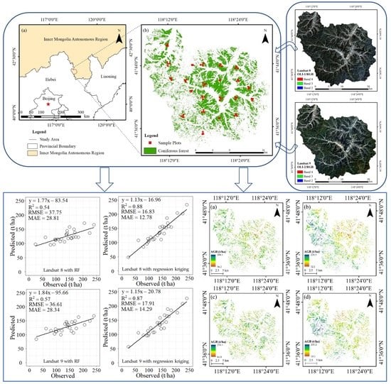
2.1. Study Area
2.2. Field Measurement of AGB
2.3. Landsat Images Preprocessing
2.4. Extraction and Selection of Feature Variables
2.5. Model Development and Assessment
2.5.1. Parametric and Nonparametric Models
2.5.2. Regression Kriging
2.5.3. Model Accuracy Assessment
3. Results
3.1. Band Analysis for Landsat 8 and Landsat 9 Images
3.2. Correlation and Importance Analysis
3.3. Comparison of Original AGB Estimation Results
3.4. Regression Kriging for AGB Estimation
3.5. Spatial Distribution of AGB in Wangyedian
4. Discussion
4.1. Comparison of AGB Estimation Models
4.2. Limitations and Prospection
5. Conclusions
Author Contributions
Funding
Data Availability Statement
Conflicts of Interest
References
- Zhang, R.; Zhou, X.; Ouyang, Z.; Avitabile, V.; Qi, J.; Chen, J.; Giannico, V. Estimating aboveground biomass in subtropical forests of China by integrating multisource remote sensing and ground data. Remote Sens. Environ. 2019, 232, 111341. [Google Scholar] [CrossRef]
- Tsogt, K.; Lin, C. A flexible modeling of irregular diameter structure for the volume estimation of forest stands. J. For. Res. 2014, 19, 1–11. [Google Scholar] [CrossRef]
- ** Forest Aboveground Biomass Using Multisource Remotely Sensed Data. Remote Sens. 2022, 14, 1115. [Google Scholar] [CrossRef]
- Beaudoin, A.; Hall, R.J.; Castilla, G.; Filiatrault, M.; Villemaire, P.; Skakun, R.; Guindon, L. Improved k-NN Map** of Forest Attributes in Northern Canada Using Spaceborne L-Band SAR, Multispectral and LiDAR Data. Remote Sens. 2022, 14, 1181. [Google Scholar] [CrossRef]
- Entwistle, N.; Heritage, G.; Milan, D. Recent remote sensing applications for hydro and morphodynamic monitoring and modelling. Earth Surf. Process. Landforms. 2018, 43, 2283–2291. [Google Scholar] [CrossRef] [Green Version]
- Thiel, C.; Schmullius, C. The potential of ALOS PALSAR backscatter and InSAR coherence for forest growing stock volume estimation in Central Siberia. Remote Sens. Environ. 2016, 173, 258–273. [Google Scholar] [CrossRef]
- Antonarakis, A.S.; Richards, K.S.; Brasington, J.; Bithell, M. Leafless roughness of complex tree morphology using terrestrial lidar. Water Resour. Res. 2009, 45, W10401. [Google Scholar] [CrossRef] [Green Version]
- Wu, J.; Yao, W.; Choi, S.; Park, T.; Myneni, R.B. A Comparative Study of Predicting DBH and Stem Volume of Individual Trees in a Temperate Forest Using Airborne Waveform LiDAR. IEEE Geosci. Remote Sens. Lett. 2015, 12, 2267–2271. [Google Scholar] [CrossRef]
- Labrecque, S.; Fournier, R.A.; Luther, J.E.; Piercey, D. A comparison of four methods to map biomass from Landsat-TM and inventory data in western Newfoundland. For. Ecol. Manag. 2006, 226, 129–144. [Google Scholar] [CrossRef]
- Amiro, B.D.; Chen, J.M. Forest-fire-scar aging using SPOT-VEGETATION for Canadian ecoregions. Can. J. For. Res. 2003, 33, 1116–1125. [Google Scholar] [CrossRef]
- Jiang, F.; Deng, M.; Long, Y.; Sun, H. Spatial Pattern and Dynamic Change of Vegetation Greenness from 2001 to 2020 in Tibet, China. Front. Plant Sci. 2022, 13, 892625. [Google Scholar] [CrossRef]
- Wilson, K.L.; Wong, M.C.; Devred, E. Comparing Sentinel-2 and WorldView-3 Imagery for Coastal Bottom Habitat Map** in Atlantic Canada. Remote Sens. 2022, 14, 1254. [Google Scholar] [CrossRef]
- Chaozong, X.; Yuxing, Z.; Wei, W. A relief-based forest cover change extraction using GF-1 images. In Proceedings of the 2014 IEEE Geoscience and Remote Sensing Symposium, Quebec City, QC, Canada, 13–18 July 2014; pp. 4212–4215. [Google Scholar] [CrossRef]
- Lu, D.; Chen, Q.; Wang, G.; Liu, L.; Li, G.; Moran, E. A survey of remote sensing-based aboveground biomass estimation methods in forest ecosystems. Int. J. Digit. Earth 2014, 9, 63–105. [Google Scholar] [CrossRef]
- Majasalmi, T.; Rautiainen, M. The potential of Sentinel-2 data for estimating biophysical variables in a boreal forest: A simulation study. Remote Sens. Lett. 2016, 7, 427–436. [Google Scholar] [CrossRef]
- Tomppo, E.O.; Gagliano, C.; De Natale, F.; Katila, M.; McRoberts, R.E. Predicting categorical forest variables using an improved k-Nearest Neighbour estimator and Landsat imagery. Remote Sens. Environ. 2009, 113, 500–517. [Google Scholar] [CrossRef]
- Phiri, D.; Morgenroth, J. Developments in Landsat Land Cover Classification Methods: A Review. Remote Sens. 2017, 9, 967. [Google Scholar] [CrossRef] [Green Version]
- Masek, J.G.; Wulder, M.A.; Markham, B.; McCorkel, J.; Crawford, C.J.; Storey, J.; Jenstrom, D.T. Landsat 9: Empowering open science and applications through continuity. Remote Sens. Environ. 2020, 248, 111968. [Google Scholar] [CrossRef]
- Chirici, G.; Barbati, A.; Corona, P.; Marchetti, M.; Travaglini, D.; Maselli, F.; Bertini, R. Non-parametric and parametric methods using satellite images for estimating growing stock volume in alpine and Mediterranean forest ecosystems. Remote Sens. Environ. 2008, 112, 2686–2700. [Google Scholar] [CrossRef] [Green Version]
- García-Gutiérrez, J.; Martínez-álvarez, F.; Troncoso, A.; Riquelme, J.C. A comparison of machine learning regression techniques for lidar-derived estimation of forest variables. Neurocomputing 2015, 167, 24–31. [Google Scholar] [CrossRef]
- Li, Y.; Han, N.; Li, X.; Du, H.; Mao, F.; Cui, L.; Liu, T.; ** the Leaf Area Index in Arid and Semi-Arid Areas of China. Remote Sens. 2020, 12, 1884. [Google Scholar] [CrossRef]
- Hengl, T.; Heuvelink, G.; Stein, A. A generic framework for spatial prediction of soil variables based on regression-kriging. Geoderma 2004, 120, 75–93. [Google Scholar] [CrossRef] [Green Version]
- Ge, Y.; Liang, Y.; Wang, J.; Zhao, Q.; Liu, S. Upscaling Sensible Heat Fluxes with Area-to-Area Regression Kriging. IEEE Geosci. Remote Sens. Lett. 2015, 12, 656–660. [Google Scholar] [CrossRef]
- Li, Y.; Li, M.; Liu, Z.; Li, C. Combining Kriging Interpolation to Improve the Accuracy of Forest Aboveground Biomass Estimation using Remote Sensing Data. IEEE Access 2020, 8, 128124–128139. [Google Scholar] [CrossRef]
- Yu, S.; Ye, Q.; Zhao, Q.; Li, Z.; Zhang, M.; Zhu, H.; Zhao, Z. Effects of Driving Factors on Forest Aboveground Biomass (AGB) in China’s Loess Plateau by Using Spatial Regression Models. Remote Sens. 2022, 14, 2842. [Google Scholar] [CrossRef]
- Coletti, C.; Ciotoli, G.; Benà, E.; Brattich, E.; Cinelli, G.; Galgaro, A.; Massironi, M.; Mazzoli, C.; Mostacci, D.; Morozzi, P.; et al. The assessment of local geological factors for the construction of a Geogenic Radon Potential map using regression kriging. A case study from the Euganean Hills volcanic district (Italy). Sci. Total Environ. 2022, 808, 152064. [Google Scholar] [CrossRef]
- Li, W.; Niu, Z.; Gao, S.; Wang, C. Map** the spatial pattern of temperate forest above ground biomass by integrating airborne lidar with Radarsat-2 imagery via geostatistical models. Lidar. Remote Sens. Environ. Monit. XIV 2014, 9262, 92620S. [Google Scholar] [CrossRef]
- ** the Global Mangrove Forest Aboveground Biomass Using Multisource Remote Sensing Data. Remote Sens. 2020, 12, 1690. [Google Scholar] [CrossRef]
- Zhang, J.; Xu, J.; Dai, X.; Ruan, H.; Liu, X.; **g, W. Multi-Source Precipitation Data Merging for Heavy Rainfall Events Based on Cokriging and Machine Learning Methods. Remote Sens. 2022, 14, 1750. [Google Scholar] [CrossRef]
- Shabou, M.; Mougenot, B.; Chabaane, Z.L.; Walter, C.; Boulet, G.; Aissa, N.B.; Zribi, M. Soil Clay Content Map** Using a Time Series of Landsat TM Data in Semi-Arid Lands. Remote Sens. 2015, 7, 6059–6078. [Google Scholar] [CrossRef] [Green Version]
- Brovkina, O.; Novotny, J.; Cienciala, E.; Zemek, F.; Russ, R. Map** forest aboveground biomass using airborne hyperspectral and LiDAR data in the mountainous conditions of Central Europe. Ecol. Eng. 2017, 100, 219–230. [Google Scholar] [CrossRef]
- Vuolo, F.; Żółtak, M.; Pipitone, C.; Zappa, L.; Wenng, H.; Immitzer, M.; Weiss, M.; Baret, F.; Atzberger, C. Data Service Platform for Sentinel-2 Surface Reflectance and Value-Added Products: System Use and Examples. Remote Sens. 2016, 8, 938. [Google Scholar] [CrossRef] [Green Version]
- Myneni, R.; Maggion, S.; Iaquinta, J.; Privette, J.; Gobron, N.; Pinty, B.; Kimes, D.; Verstraete, M.; Williams, D. Optical remote sensing of vegetation: Modeling, caveats, and algorithms. Remote Sens. Environ. 1995, 51, 169–188. [Google Scholar] [CrossRef]
- Banskota, A.; Kayastha, N.; Falkowski, M.J.; Wulder, M.A.; Froese, R.E.; White, J.C. Forest Monitoring Using Landsat Time Series Data: A Review. Can. J. Remote Sens. 2014, 40, 362–384. [Google Scholar] [CrossRef]
- Seydi, S.; Akhoondzadeh, M.; Amani, M.; Mahdavi, S. Wildfire Damage Assessment over Australia Using Sentinel-2 Imagery and MODIS Land Cover Product within the Google Earth Engine Cloud Platform. Remote Sens. 2021, 13, 220. [Google Scholar] [CrossRef]
- Tassi, A.; Vizzari, M. Object-Oriented LULC Classification in Google Earth Engine Combining SNIC, GLCM, and Machine Learning Algorithms. Remote Sens. 2020, 12, 3776. [Google Scholar] [CrossRef]
- Tamiminia, H.; Salehi, B.; Mahdianpari, M.; Quackenbush, L.; Adeli, S.; Brisco, B. Google Earth Engine for geo-big data applications: A meta-analysis and systematic review. ISPRS J. Photogramm. Remote Sens. 2020, 164, 152–170. [Google Scholar] [CrossRef]


| Tree Species | Number | Value Range (t/ha) | Mean (t/ha) | Standard Deviation (t/ha) | Coefficient of Variation (%) |
|---|---|---|---|---|---|
| Larch | 41 | 24.56–207.17 | 115.95 | 49.14 | 42.3 |
| Chinese pine | 45 | 28.48–459.62 | 138.29 | 64.63 | 46.7 |
| Scots pine | 2 | 91.04–148.38 | 119.71 | 40.55 | 33.9 |
| Total | 88 | 24.56–459.62 | 127.46 | 58.01 | 45.5 |
| Spectral Bands | Wavelength Range (nm) | Spatial Resolution (m) | |
|---|---|---|---|
| Landsat 8/OLI-1 | Landsat 9/OLI-2 | ||
| Band 1—Coastal | 435–451 | 435–450 | 30 |
| Band 2—Blue | 452–512 | 452–512 | 30 |
| Band 3—Green | 533–590 | 532–589 | 30 |
| Band 4—Red | 636–673 | 636–672 | 30 |
| Band 5—NIR | 851–879 | 850–879 | 30 |
| Band 6—SWIR 1 | 1566–1651 | 1565–1651 | 30 |
| Band 7—SWIR 2 | 2107–2294 | 2105–2294 | 30 |
| Band 8—Panchromatic | 504–676 | 503–675 | 15 |
| Band 9—Cirrus | 1363–1384 | 1363–1384 | 30 |
| Landsat 8/TIRS-1 | Landsat 9/TIRS-2 | ||
| Band 10—TIRS 1 | 10.60–11.18 | 10.45–11.20 | 100 |
| Band 11—TIRS 2 | 11.51–12.50 | 11.58–12.50 | 100 |
| Variable Type | Feature Variable | Reference |
|---|---|---|
| Spectral variable | Band reflectance (Band i, i = 1, 2, …7) | [43] |
| Normalized difference vegetation index (NDVI) | [51] | |
| Red–green vegetation index (RGVI) | [52] | |
| Atmospherically resistant vegetation index (ARVI) | [52] | |
| Enhanced vegetation index (EVI) | [53] | |
| Visible atmospherically resistant index (VARI) | [54] | |
| Soil-adjusted vegetation index (SAVI) | [55] | |
| Modified soil-adjusted vegetation index (MSAVI) | [56] | |
| Texture feature | Mean | [59] |
| Variance | [59] | |
| Homogeneity | [59] | |
| Contrast | [59] | |
| Dissimilarity | [59] | |
| Entropy | [59] | |
| Second moment | [59] | |
| Correlation | [59] | |
| Topographic factor | Elevation | [9] |
| Slope | [9] | |
| Aspect | [9] |
| Bands | Landsat 8 | Landsat 9 | Correlation Coefficient | ||||
|---|---|---|---|---|---|---|---|
| Mean | Standard Deviation | Coefficient of Variation (%) | Mean | Standard Deviation | Coefficient of Variation (%) | ||
| B1 | 0.10 | 0.13 | 127.21 | 0.23 | 0.24 | 104.29 | 0.77 |
| B2 | 0.09 | 0.13 | 135.17 | 0.21 | 0.23 | 108.53 | 0.79 |
| B3 | 0.11 | 0.13 | 120.85 | 0.23 | 0.24 | 104.37 | 0.82 |
| B4 | 0.13 | 0.14 | 107.60 | 0.24 | 0.24 | 99.75 | 0.85 |
| B5 | 0.19 | 0.13 | 69.27 | 0.29 | 0.21 | 74.41 | 0.89 |
| B6 | 0.14 | 0.11 | 78.69 | 0.09 | 0.06 | 64.21 | 0.85 |
| B7 | 0.11 | 0.08 | 78.20 | 0.07 | 0.04 | 61.17 | 0.87 |
Publisher’s Note: MDPI stays neutral with regard to jurisdictional claims in published maps and institutional affiliations. |
© 2022 by the authors. Licensee MDPI, Basel, Switzerland. This article is an open access article distributed under the terms and conditions of the Creative Commons Attribution (CC BY) license (https://creativecommons.org/licenses/by/4.0/).
Share and Cite
Jiang, F.; Sun, H.; Chen, E.; Wang, T.; Cao, Y.; Liu, Q. Above-Ground Biomass Estimation for Coniferous Forests in Northern China Using Regression Kriging and Landsat 9 Images. Remote Sens. 2022, 14, 5734. https://doi.org/10.3390/rs14225734
Jiang F, Sun H, Chen E, Wang T, Cao Y, Liu Q. Above-Ground Biomass Estimation for Coniferous Forests in Northern China Using Regression Kriging and Landsat 9 Images. Remote Sensing. 2022; 14(22):5734. https://doi.org/10.3390/rs14225734
Chicago/Turabian StyleJiang, Fugen, Hua Sun, Erxue Chen, Tianhong Wang, Yaling Cao, and Qingwang Liu. 2022. "Above-Ground Biomass Estimation for Coniferous Forests in Northern China Using Regression Kriging and Landsat 9 Images" Remote Sensing 14, no. 22: 5734. https://doi.org/10.3390/rs14225734