
The Detection and Control Factor Analysis of Active Landslides in Guizhou Province, China, Using Sentinel-1 SAR Imagery

Abstract
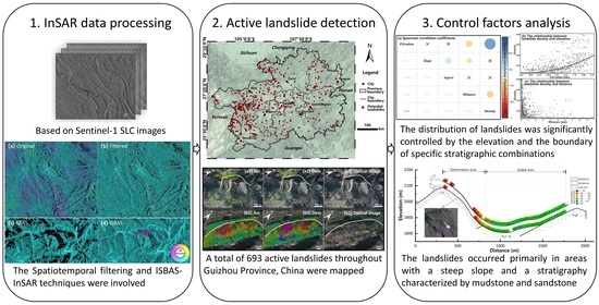
:
1. Introduction
2. Study Area
3. Data and Methods
3.1. Data
3.2. Methods
3.2.1. ISBAS-InSAR
3.2.2. Temporal and Spatial Filtering
4. Results
4.1. Error Correction and Monitoring Point Improvement
4.2. InSAR Deformation Rates for Guizhou Province
4.3. The Distribution of Active Landslides in Guizhou
4.4. Distribution Pattern of the Active Landslides in Terms of Topographic Factors
5. Discussion
5.1. Distribution Pattern of the Active Landslides in Terms of Geological Factors
5.2. The Key Control Factors of Landslide Distribution
5.3. Verification of Key Landslide Control Factors
6. Conclusions
Author Contributions
Funding
Data Availability Statement
Acknowledgments
Conflicts of Interest
References
- Feng, Z.; Li, B.; Yin, Y.; He, K. Rockslides on limestone cliffs with subhorizontal bedding in the southwestern calcareous area of China. Nat. Hazards Earth Syst. Sci. 2014, 14, 2627–2635. [Google Scholar] [CrossRef]
- Cui, F.; Li, B.; ** active landslides along the **sha River corridor, China. Eng. Geol. 2021, 284, 106033. [Google Scholar] [CrossRef]
- Costantini, M.; Ferretti, A.; Minati, F.; Falco, S.; Trillo, F.; Colombo, D.; Novali, F.; Malvarosa, F.; Mammone, C.; Vecchioli, F. Analysis of surface deformations over the whole Italian territory by interferometric processing of ERS, Envisat and COSMO-SkyMed radar data. Remote Sens. Environ. 2017, 202, 250–275. [Google Scholar] [CrossRef]
- Wasowski, J.; Bovenga, F. Investigating landslides and unstable slopes with satellite Multi Temporal Interferometry: Current issues and future perspectives. Eng. Geol. 2014, 174, 103–138. [Google Scholar] [CrossRef]
- Sonnessa, A.; di Lernia, A.; Nitti, D.O.; Nutricato, R.; Tarantino, E.; Cotecchia, F. Integration of multi-sensor MTInSAR and ground-based geomatic data for the analysis of non-linear displacements affecting the urban area of Chieuti, Italy. Int. J. Appl. Earth Obs. Geoinf. 2023, 117, 103194. [Google Scholar] [CrossRef]
- Mondini, A.C.; Guzzetti, F.; Chang, K.-T.; Monserrat, O.; Martha, T.R.; Manconi, A. Landslide failures detection and map** using Synthetic Aperture Radar: Past, present and future. Earth-Sci. Rev. 2021, 216, 103574. [Google Scholar] [CrossRef]
- Pepe, A.; Calò, F. A review of interferometric synthetic aperture RADAR (InSAR) multi-track approaches for the retrieval of Earth’s surface displacements. Appl. Sci. 2017, 7, 1264. [Google Scholar] [CrossRef]
- Bekaert, D.P.; Handwerger, A.L.; Agram, P.; Kirschbaum, D.B. InSAR-based detection method for map** and monitoring slow-moving landslides in remote regions with steep and mountainous terrain: An application to Nepal. Remote Sens. Environ. 2020, 249, 111983. [Google Scholar] [CrossRef]
- Bouali, E.H.; Oommen, T.; Escobar-Wolf, R. Map** of slow landslides on the Palos Verdes Peninsula using the California landslide inventory and persistent scatterer interferometry. Landslides 2018, 15, 439–452. [Google Scholar] [CrossRef]
- Zhu, Y.; Yao, X.; Yao, L.; Yao, C. Detection and characterization of active landslides with multisource SAR data and remote sensing in western Guizhou, China. Nat. Hazards 2022, 111, 973–994. [Google Scholar] [CrossRef]
- Shen, C.; Feng, Z.; ** landslides in mountainous regions: A case study in Eldorado National Forest, California. Remote Sens. Environ. 2021, 258, 112400. [Google Scholar] [CrossRef]
- Berardino, P.; Fornaro, G.; Lanari, R.; Sansosti, E. A new algorithm for surface deformation monitoring based on small baseline differential SAR interferograms. IEEE Trans. Geosci. Remote Sens. 2002, 40, 2375–2383. [Google Scholar] [CrossRef]
- Goldstein, R.M.; Werner, C.L. Radar interferogram filtering for geophysical applications. Geophys. Res. Lett. 1998, 25, 4035–4038. [Google Scholar] [CrossRef]
- Pepe, A.; Lanari, R. On the extension of the minimum cost flow algorithm for phase unwrap** of multitemporal differential SAR interferograms. IEEE Trans. Geosci. Remote Sens. 2006, 44, 2374–2383. [Google Scholar] [CrossRef]
- Costantini, M. A novel phase unwrap** method based on network programming. IEEE Trans. Geosci. Remote Sens. 1998, 36, 813–821. [Google Scholar] [CrossRef]
- Bateson, L.; Cigna, F.; Boon, D.; Sowter, A. The application of the Intermittent SBAS (ISBAS) InSAR method to the South Wales Coalfield, UK. Int. J. Appl. Earth Obs. Geoinf. 2015, 34, 249–257. [Google Scholar] [CrossRef]
- Sowter, A.; Bateson, L.; Strange, P.; Ambrose, K.; Syafiudin, M.F. DInSAR estimation of land motion using intermittent coherence with application to the South Derbyshire and Leicestershire coalfields. Remote Sens. Lett. 2013, 4, 979–987. [Google Scholar] [CrossRef]
- Schmidt, D.A.; Bürgmann, R. Time-dependent land uplift and subsidence in the Santa Clara valley, California, from a large interferometric synthetic aperture radar data set. J. Geophys. Res. Solid Earth 2003, 108, 1–13. [Google Scholar] [CrossRef]
- Morishita, Y.; Lazecky, M.; Wright, T.J.; Weiss, J.R.; Elliott, J.R.; Hooper, A. LiCSBAS: An open-source InSAR time series analysis package integrated with the LiCSAR automated Sentinel-1 InSAR processor. Remote Sens. 2020, 12, 424. [Google Scholar] [CrossRef]
- Hooper, A.; Segall, P.; Zebker, H. Persistent scatterer interferometric synthetic aperture radar for crustal deformation analysis, with application to Volcán Alcedo, Galápagos. J. Geophys. Res. Solid Earth 2007, 112, 1–21. [Google Scholar] [CrossRef]
- Li, B.; Zhao, C.; Li, J.; Chen, H.; Gao, Y.; Cui, F.; Wan, J. Mechanism of mining-induced landslides in the karst mountains of Southwestern China: A case study of the Baiyan landslide in Guizhou. Landslides 2023, 20, 1481–1495. [Google Scholar] [CrossRef]


| No. | Path | Frame | Flight Direction | Epoch | Image Number |
|---|---|---|---|---|---|
| 1 | 128 | 84 | Ascending | 2 January 2018–21 April 2020 | 65 |
| 2 | 128 | 79 | Ascending | 20 March 2017–5 May 2022 | 155 |
| 3 | 128 | 74 | Ascending | 2 January 2018–21 April 2020 | 71 |
| 4 | 55 | 87 | Ascending | 9 January 2018–28 April 2020 | 69 |
| 5 | 55 | 82 | Ascending | 9 January 2018–30 November 2020 | 65 |
| 6 | 55 | 77 | Ascending | 9 January 2018–30 November 2020 | 85 |
| 7 | 157 | 87 | Ascending | 4 January 2018–23 April 2020 | 70 |
| 8 | 157 | 82 | Ascending | 4 January 2018–23 April 2020 | 71 |
| 9 | 157 | 77 | Ascending | 4 January 2018–23 April 2020 | 71 |
| 10 | 164 | 500 | Descending | 4 January 2018–23 April 2020 | 70 |
| 11 | 164 | 505 | Descending | 10 March 2017–24 May 2022 | 122 |
| 12 | 164 | 510 | Descending | 4 January 2018–23 April 2020 | 70 |
Disclaimer/Publisher’s Note: The statements, opinions and data contained in all publications are solely those of the individual author(s) and contributor(s) and not of MDPI and/or the editor(s). MDPI and/or the editor(s) disclaim responsibility for any injury to people or property resulting from any ideas, methods, instructions or products referred to in the content. |
© 2023 by the authors. Licensee MDPI, Basel, Switzerland. This article is an open access article distributed under the terms and conditions of the Creative Commons Attribution (CC BY) license (https://creativecommons.org/licenses/by/4.0/).
Share and Cite
Chen, L.; Zhao, C.; Chen, H.; Kang, Y.; Li, B.; Liu, X. The Detection and Control Factor Analysis of Active Landslides in Guizhou Province, China, Using Sentinel-1 SAR Imagery. Remote Sens. 2023, 15, 5468. https://doi.org/10.3390/rs15235468
Chen L, Zhao C, Chen H, Kang Y, Li B, Liu X. The Detection and Control Factor Analysis of Active Landslides in Guizhou Province, China, Using Sentinel-1 SAR Imagery. Remote Sensing. 2023; 15(23):5468. https://doi.org/10.3390/rs15235468
Chicago/Turabian StyleChen, Liquan, Chaoying Zhao, Hengyi Chen, Ya Kang, Bin Li, and **aojie Liu. 2023. "The Detection and Control Factor Analysis of Active Landslides in Guizhou Province, China, Using Sentinel-1 SAR Imagery" Remote Sensing 15, no. 23: 5468. https://doi.org/10.3390/rs15235468