The application of remote sensing technology in the investigation and dynamic monitoring of CMPRs is the focus of the research on the sustainable development of CMMRs, and the selection of appropriate data sources is the primary task of remote sensing monitoring of medicinal plant resources. How to select remote sensing data according to the types of CMPs to participate in the research has become a problem that many scholars need to consider first. The responses of different planting patterns and habitat characteristics to the monitoring of CMPRs should be explored in combination with actual planting characteristics, and more appropriate data sources should be selected according to the distribution and research value of medicinal plant resources in the study area. On the one hand, the accuracy of remote sensing monitoring of medicinal plant resources should be ensured; on the other hand, resource waste caused by purchasing high-resolution data sources should be avoided. Therefore, it is necessary to select appropriate data sources through research to provide reliable information for researchers of CMPRs.
2.1. Planting Patterns and Habitat Characteristics
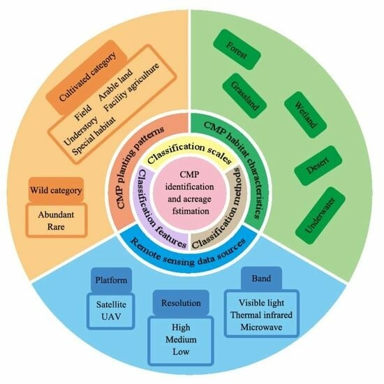
In terms of planting patterns, CMPRs can be divided into wild and cultivated categories [
10]. The former refers to non-artificially planted CMPRs distributed in a certain geographical area. There are various kinds of wild medicinal plant resources and different habitats in China. According to their living types, they can be categorized into woody plants (trees, shrubs, bamboo, vines, epiphytes, and parasitic trees), semi-woody plants (semi-shrubs and dwarf shrubs), herbaceous plants (perennial herbaceous plants, annual herbaceous plants, parasitic herbaceous plants, saprophytic herbaceous plants, and aquatic herbaceous plants), and thallophytes (mosses and lichens, algae, and fungi) [
11]. Wild medicinal resources can also be further divided into abundant and rare plant species. Tree-based medicinal resources are generally densely distributed and have large scales, while shrubs are not as tall and independently distributed as trees and are more common in mountain grasslands and understories at higher elevations, making remote sensing identification and extraction of shrub-based medicinal plants more complex.
For rare medicinal plant resources, firstly, the distribution of wild rare medicinal plant resources is not concentrated in a single or dominant population but dispersed across different plant communities and geographically dispersed [
7], which also creates certain difficulties in selecting remote sensing monitoring methods. Secondly, multi-spectral remote sensing data generally cannot directly obtain information on rare medicinal plant resources but can monitor vegetation cover in the medicinal plant habitat. Therefore, research on remote sensing monitoring methods for rare medicinal plant resources can be used to establish the inherent connection between the number of rare medicinal plant species and remote sensing monitoring methods to investigate the amount of rare medicinal plant resources. The selection of remote sensing images should be based on the characteristics of the rare medicinal resources themselves. When using remote sensing images for data information extraction, the spatial resolution, spectral resolution, and radiation resolution of the data should be considered from the perspective of monitoring rare medicinal plant resources.
At present, the natural quantity of rare medicinal plant resources in China is decreasing year by year [
12] due to people’s pursuit of wild rare medicinal plant resources in recent years and their destruction of the ecological environment system, which has led to a continuous decline in the number of rare wild medicinal plant resources. In this situation, cultivated medicinal plant resources have also received increasing attention [
13]. On the one hand, cultivated medicinal plant resources can further alleviate the market demand. In this social context, remote sensing monitoring methods can effectively estimate the total amount, output, and demand of cultivated medicinal plant resources overall. Cultivated medicinal plants are mostly centrally distributed and recorded for filing, making it easier to analyze their resource distribution and information extraction than for wild medicinal plants. The investigation of cultivated medicinal plant resources, the calculation of the planting area, and the estimation of reserves can prevent the blind introduction of cultivation and provide a theoretical basis for guiding scientific and reasonable site selection for cultivation bases. Therefore, remote sensing identification and area extraction estimation of cultivated medicinal plant resources are important. More than 200 kinds of medicinal plants commonly used in China are mainly cultivated artificially. Due to the influence of growth years, planting areas, and management methods, the area and yield of medicinal plants obtained by conventional methods have a large error. Remote sensing technology has important application value and guiding significance in estimating and predicting the area and yield of cultivated medicinal plants [
14]. Cultivated medicinal plants are mainly categorized based on their planting patterns: field cultivation, arable land cultivation, understory cultivation (intercrop**), facility agriculture (greenhouse) cultivation, and special habitat cultivation. The research results of remote sensing in the field cultivation of CMPs can refer to the more mature remote sensing monitoring methods of some crops, and they are easier to carry out than other planting modes.
Figure 2 shows classification of planting patterns of CMPs and examples of CMPs in different planting patterns.
Nowadays, in the research on remote sensing in the field of identification and classification of CMP arable-land-based cultivation and understory cultivation (intercrop**), the lack of a large number of annotated data in the corresponding field and the subjectivity of manually annotated data have generally been mentioned by scholars [
15]. In the case of dispersed planting of multiple kinds of traditional CMPRs within the same administrative region, if precise discrimination of the distribution area of each CMPR is required, an unmanned aerial vehicle (UAV) low-altitude remote sensing system can be used to obtain high-resolution image data of the ground, combined with texture and spectral features and ground surveys for further accurate and quantitative analysis, and secondary verification can be performed with ground sample data. Using this method, the assessment accuracy of the UAV remote sensing system in identifying, classifying, and performing area extraction for CMPRs can be confirmed to distinguish different CMPR types and distribution areas with a certain level of accuracy. Some CMPs do require intercrop** with other crops to improve quality and yield. Since the spectrum characteristics of each plant and the modes of interplanting and single species are different, different classification models need to be constructed for different situations when using remote sensing image recognition to extract planting distribution areas. The typical CMP in a facility agriculture (greenhouse) model is greenhouse-cultivated ginseng, which is grown in a common warm greenhouse. The obstacle of continuous crop** of greenhouse-cultivated ginseng is an important factor restricting the planting of greenhouse-cultivated ginseng. The available ginseng resources are an important weakness that troubles the development of the ginseng industry. The dynamic monitoring of plantation distribution area and area changes using remote sensing technology is of guiding significance for the production and planning of ginseng. The roof of the ginseng shed is made of plastic film. Because of this planting mode, the garden ginseng has a particularly prominent advantage in satellite remote monitoring. Compared with the surrounding forest vegetation, the characteristics of the ginseng shed in remote sensing images are more prominent.
In addition to diverse planting patterns, China has a rich and complex ecosystem, and the distribution of CMPRs varies greatly depending on the ecosystem. CMPRs have significant regional characteristics [
16], and spatial characteristics and geographical environments play a decisive role in sha** the quality of CMPs, i.e., the “stress response” of medicinal plants [
17]. Medicinal plants in different habitats have different spectral reflectance characteristics, which can be monitored using remote sensing techniques. In addition, some scholars use habitat factor interaction and correlation analysis with effective components of CMPs, combined with spatial overlap** analysis, to extract suitable areas for CMPs. On the basis of literature review and analysis of ecological factors such as elevation, annual precipitation and average annual temperature, Dong et al. [
18] studied the distribution area of
Swertia mussotii Franch. in Sichuan province by obtaining ecological factors, superposition analysis and GPS field verification data based on remote sensing and GIS technology. Remote sensing techniques are also involved in medicinal plants in some special habitats. Medicinal plants in certain special aquatic ecological environments can be monitored using different remote sensing methods based on their unique ecological environment information. For example, radar remote sensing can be used to estimate the resource quantity of aquatic TCM lotus, and remote sensing technology can be used to extract the special ecological environment of the parasitic plant
Cistanche deserticola Y. C. Ma and some symbiotic plants in the desert for resource quantity estimation due to their special ecological environment types. Different types of medicinal plants have different special characteristics. Therefore, how to extract specific medicinal plant cultivation information should be analyzed according to its characteristics, and reasonable and effective remote sensing survey methods should be adopted. It is impossible to use a universal method for all cases.
2.2. Data Sources
The planting patterns and habitat characteristics of CMPs were introduced in the previous article. The selection of remote sensing data sources for monitoring CMPs should take these characteristics into account. Although the spatial resolution of early high-resolution satellites can be as high as meters, the number of bands is small, and image recognition needs to cooperate with the human eye. Chen et al. [
9] used Landsat-7 ETM data from the United States, SPOT 5 data from France, and QuickBird image data from the United States to identify Jilin ginseng, mainly using manual interpretation and automatic interpretation methods. The results showed that the manual interpretation accuracy of high-resolution satellite images can reach 100%, the combination of medium-high and medium-resolution images can reach 97%, and medium-resolution satellite images can reach 90%. Although the former two have high accuracy, the cost is also high, and the manual interpretation cannot be widely promoted. Meanwhile, the workload of manual interpretation is large and time-consuming. This study explored a method for applying remote sensing technology to investigate medicinal plants. Zhang et al. [
19] measured the area of wild
Glycyrrhiza uralensis Fisch in Yanchi County, Ningxia Hui Autonomous Region, located on the Ordos Plateau, using medium-resolution ETM (15 m) satellite images combined with field data and the visual interpretation method. The comparative analysis of field verification points and image interpretation results showed that the manual interpretation accuracy of the survey sample area reached 90% when the ground resolution was 15 m, 97% when the ground resolution was 5 m, and 100% when the ground resolution was 0.61 m. This indicates that the higher the resolution of remote sensing data, the better the recognition accuracy in the survey of large area wild
G. uralensis Fisch resources. This study discussed the influence of the spatial resolution of remote sensing data on extraction accuracy, provided a technical reference for the area estimation of large areas of wild Chinese medicinal materials, and provided a great technical scheme for wild resources investigation. Bahdu [
20] studied the planting area of
Carthamus tinctorius L. using data sources with different resolutions, such as the Worldview-2 satellite, ZY-3 satellite, and ZY-1 02C satellite, and found that high-resolution data could greatly improve the interpretation accuracy of
C. tinctorius L., but it was difficult for automatic interpretation of
C. tinctorius L. In order to analyze and compare which data source is more suitable for remote sensing identification of wild medicinal vegetation with more complex growth conditions, Na et al. [
21,
22] took wild
Apocynum venetum L. nature reserve in Altai Alahak Township as the research object and adopted the medium-low resolution remote sensing image of domestic satellite ZY-3 and the high-resolution remote sensing image of foreign satellite Worldview-2. In this study, the same classification system was adopted for the two data sources, and the primary component analysis and texture feature were added to the traditional classification method to improve the classification accuracy. It was found that the high-resolution image of Worldview-2 was more suitable for the remote sensing identification of wild
A. venetum L. with more complex growth conditions, while the domestic medium- and low-resolution ZY-3 was only suitable for the identification of densely distributed
A. venetum L. and could not identify sporadic
A. venetum L. Therefore, selecting remote sensing data sources should be based on the distribution of target objects in the specific work area. If the target objects in the study area are densely distributed and large in scale, such as artificial cultivation or single growing medicinal plant, the target objects can be identified well using remote sensing data of medium and low resolution, and there is no need to purchase high-resolution data, thus avoiding resource waste. For objects scattered and accompanied by other wild vegetation, it is considered that high-resolution satellite image data can be used to identify the objects well. Scattered wild medicinal plants are mostly planted in mountainous areas with suitable natural environmental conditions and complex terrain, and the planting plots are scattered. It is vital to provide decision support for the protection and utilization of CMMRs by studying the extraction method of the CMP planting area based on remote sensing. With the development of space remote sensing data in the direction of high spatial and temporal resolution, rich spectrum information, and wide band coverage, it has increasingly met the needs of large-scale surveys of CMMRs. Some scholars have applied Sentinel-2 [
23] data and GF-6 data [
24] to identify medicinal plants and achieved good results.
In addition, the unmanned aerial vehicle low-altitude remote sensing system (UAVRS) has the advantages of low cost, flexible and convenient operation and control, low-altitude flight under clouds, high timescales, etc. [
14]. The spatial resolution has reached the centimeter level [
25], which meets the sampling accuracy requirements, greatly reduces working time and human and material resources, and can also be used for the survey of CMMRs collected. It is especially suitable for rare medicinal plants with dispersed distribution and complex habitats. According to the characteristics of different remote sensing platforms and the distribution of medicinal plant resources, **, and intercrop** phenomena [
49], such as bupleur–maize intercrop**, rice–Coptis rice–water and drought rotation, Pinellia–maize intercrop**, and so on. There were differences in spatial pattern, vertical distribution, and time variation among different planting patterns of CMPs.
At the same time, unlike the large-scale cultivation of traditional food crops, the cultivation of Chinese medicinal materials is relatively scattered, with small plots and fragmented landscapes [
50]. In this case, spectral feature recognition using satellite remote sensing data is prone to mixed-pixel problems. These characteristics of CMP planting have created new requirements for remote sensing technology in terms of spatial resolution, time resolution, spectral recognition degree, recognition features, and recognition methods. It is therefore necessary to explore new remote sensing technology.
How to make full use of multi-source data is a key issue that needs to be considered. Remote sensing identification and area extraction of CMPs involve many types, which require high spatial, temporal, and spectral resolutions of remote sensing images. How to deal with the contradictory relationship between the spectral, temporal, and spatial resolution to realize the identification of CMPRs and the accurate extraction of the planting area is a problem that needs to be considered. In addition, it has also been mentioned above that non-remote sensing data sources, such as meteorology, topography, and phenology, are often introduced into the extraction of auxiliary plant planting information of CMPs to improve the accuracy of remote sensing extraction. However, the quality of data from different sources and the difference in spatial and temporal scales will affect the accuracy of remote sensing extraction in turn. Therefore, future research needs to strengthen the research on the substitution and integration of multi-source data to achieve the “complementary advantages” between different data sources.
4.2. Prospects
There are a variety of cultivation patterns for medicinal plants. In addition, the distribution of CMPs in different ecosystems is varied and has significant regional characteristics [
51], leading to complex habitat characteristics. A sample database with reasonable classification and a sufficient quantity of information such as planting patterns, habitat characteristics, and phenological characteristics of medicinal plants should be built and applied to remote sensing recognition of medicinal plants in combination with data assimilation technology. The classification algorithm can be guided by the information in the database to improve the accuracy of the identification of medicinal plants and to understand the distribution and growth of medicinal plants more accurately. Therefore, different monitoring schemes can be developed for different models of CMPs.
(1) For CMPs planted in cultivated fields and greenhouses, the planting mode is relatively simple, and the surface distribution and spectral characteristics are obvious. Based on the appropriate adjustment of the existing remote sensing identification technology methods for crop and land-cover types, the corresponding remote sensing identification and spatial distribution map** can be carried out. After the improvement in monitoring technology and accuracy evaluation, this kind of CMP can be demonstrated and applied in a wide range to form the spatial distribution map and area data of the corresponding CMPs. Among them, based on the accurate identification of CMPs grown in the field, it can also carry out theme monitoring and application, including growth monitoring, maturity prediction, and unit yield estimation, which can support production management situation research and judgment.
(2) For the cultivation of CMPs under forest and other field conditions, the planting mode is complex, the planting plot is broken, and the spectral characteristics are difficult to obtain due to the influence of vertical structure. At the same time, spectral and mixed pixel interference are serious due to the influence of adjacent vegetation and surrounding high vegetation. Given this situation, it is necessary to fully discover the characteristics of multi-spectral and multi-feature remote sensing technology and combine optical and microwave data, microwave data of different bands (C\X\S band), and microwave data of different polarizations (VV\VH\HH\HV) to explore the technology and method of identification and monitoring by combining multi-source remote sensing data.
(3) For the cultivation of CMPs under complex landscape patterns and CMPs under complex terrain and special habitats, the existing identification cannot be directly applied due to the complexity of their species patterns. It is necessary to carry out a targeted analysis of its spatial distribution landscape pattern and optimize the satellite remote sensing data with a corresponding resolution based on the monitoring scale. Then, the spectral and spatial characteristics were analyzed to form the recognition feature system. Finally, the application effect of different classification methods in crop recognition was discussed, and the suitable recognition method was optimized. Through the breakthrough of recognition scale, recognition feature, and recognition method, a suitable recognition technology and process were formed and applied.
Spectral data have important reference significance for remote sensing signals to identify ground objects and extract land surface information. Research on the spectral features of ground objects has attracted attention since the 1940s, and establishing a spectral database of ground objects plays an important role in quantitative remote sensing modeling, land surface parameter inversion, and environmental ecological monitoring. In recent years, various research institutions at home and abroad have built part of the ground object spectrum database [
52,
53,
54], which better supports the research in ground object classification and target recognition. There is no spectral sample database for CMPs, with few sample data and scattered management. At the same time, there is a lack of a data-driven large-scale sample database covering different planting patterns and habitat characteristics, as well as multi-type sample data of CMPs such as multi-spectral, hyperspectral, and infrared [
55].
Based on the spectral data of ground objects, the spectral characteristics of CMPs in visible light, near-infrared, and short-wave infrared can be studied. The spectral changes in plants under different climates, terrains, and nutrient conditions can be analyzed. The amplitude and rate of spectral variation in different growth stages of TCM plants can be analyzed, and the observation window and potential identification bands of TCM plants can be proposed. The difference in spectral characteristics between different TCM plants and between TCM plants and other plants can be analyzed, and the spectral characteristic parameters of TCM plant recognition can be established. The establishment of a CMP spectral database, the study of the relationship between CMP spectral features and remote sensing information, and the matching and recognition of non-imaging spectral data and multi-spectral imaging data can provide a theoretical basis for the remote sensing identification of CMPs and play an important role in the construction of CMP information. In particular, the main research object of species identification of wild medicinal plants should be the individual wild medicinal plants. The key technical links need to use ground-based spectrometers to measure and obtain the spectral data of medicinal plants, analyze and study them, clarify the spectral characteristics of each medicinal plant species, and establish the standard spectral characteristics database of medicinal plant species. It should be noted that in the process of establishing the database, in addition to making it have a complete analysis function, strict data specification standards should be established. The establishment of a spectral database of medicinal plants is a complex and continuous work, which requires many efforts and resources. At the same time, the spectral characteristics of different medicinal plants may vary greatly, so it is necessary to take this diversity into account and develop corresponding data collection and analysis strategies. In addition, even for the same variety, under different growth environmental conditions its spectral data are significantly different, and samples of various medicinal plants should be collected from different geographical locations to ensure that a variety of species and growth environments are covered. At the time of sample collection, data such as detailed geographic information, growth conditions, and growth stage are recorded, which will facilitate subsequent data analysis. Over time, as new data and technologies become available, spectral databases need to be constantly updated and improved.
From the perspective of data source selection, the data sources applied to extract CMP information using remote sensing technology should be diversified. At present, most studies focus on the use of a single data source; however, the use of a single data source makes it difficult to meet the needs of high-precision extraction of medicinal plant information. Satellite remote sensing data are also sometimes affected by clouds, bad weather, orbital period, resolution, and other factors, resulting in data pollution, reducing remote sensing observation, and increasing the spatio-temporal discontinuity of remote sensing observation [
56]. UAVRS makes up for this shortage with its flexibility, convenience, low cost of data acquisition, and the ability to fly at low altitudes under clouds [
57,
58]. The development of UAVRS technology has improved the accuracy and real-time performance of data collection and area extraction and expanded the application scope of medicinal plant resources research based on satellite remote sensing. It has accumulated valuable experience and provided reference value for UAVRS in the future extraction of large-area wild medicinal resources information. Microwave remote sensing has the advantages of working all day in all weather and strong penetration [
59]. If it is applied to the dynamic monitoring of CMMRs, it can make the data acquisition independent of the local weather, and for some short varieties of CMPs shielded by the canopy, they can also be successfully monitored. Using multi-source and multi-temporal data fusion technology, multi-source data improve the spatial resolution of remote sensing images, and multi-temporal data improve the time resolution of remote sensing images, which is beneficial to obtain the best time phase of medicinal plant remote sensing information, better characterize the whole process of growth and development of medicinal plants, and improve the accuracy of CMP identification and information extraction.
With the development of science and technology in remote sensing data sources, the relationship between spectral resolution, spatial resolution, and temporal resolution of remote sensing data should be fully considered in view of different planting patterns and habitat characteristics of medicinal plants, combined with space remote sensing and aerial remote sensing data, as well as optical, thermal infrared, and microwave remote sensing data. Therefore, it is also necessary to strengthen the research on the scale conversion of multi-source data. It is important to improve the flexibility and accuracy of planting information extraction of plant CMMRs, meet the needs of dynamic and real-time monitoring under the broken agricultural landscape pattern, and improve the algorithm to solve or alleviate the problem of significantly reduced spatial independence of forecast data in view of the current various spatial–temporal data fusion technologies, which will reduce the spatial independence of data. Using the fused multi-source remote sensing data, the ability of feature extraction and data mining is improved so as to further improve the accuracy of medicinal plant resource information extraction. If the data of a single period do not meet the accuracy requirements for extracting information, establishing a technical system for comprehensive identification of medicinal plants with multi-source remote sensing data of the whole growth period should also be considered.
The continuous development of deep learning technology has also shown great potential in the automatic remote sensing monitoring and classification of CMPs. Compared with traditional methods, deep learning technology can automatically learn and extract the characteristics of medicinal plants in remote sensing monitoring and identification classification of medicinal plants, which greatly reduces the cost of manual intervention. This automatic feature extraction method can not only significantly improve the accuracy of monitoring and recognition classification but also shorten the start-up cycle and theoretical threshold. In addition, deep learning technology can deal with more complex data features and has higher flexibility and adaptability [
60], as well as very good compatibility and integration capabilities. These advantages jointly promote the continuous exploration and progress of automatic monitoring, identification, and classification of medicinal plants in the field of remote sensing. Therefore, the quality and quantity of data used for deep learning model training, the appropriate network architecture, and the selection and extraction of optimal features need to be focused on. In particular, the selection of feature variables for the classification of medicinal plants has great limitations, and more attention is paid to the characteristics of medicinal plants in experimental areas, and its planting and phenological characteristics are rarely considered. It is important to make full use of the advantages of deep learning in information mining and extraction and apply it as a tool in remote sensing identification of CMP planting types and remote sensing inversion of physiological/biochemical parameters so as to improve the ability and accuracy of CMP monitoring. Evaluating the contribution rate of different features to crop classification and identification and determining the key set of identifying features for different medicinal plant types and their combinations is a concept that can be explored in future research. After improving the feature extraction method of the existing deep convolutional neural network, the method test and accuracy evaluation are carried out through the changes in samples. According to different planting patterns, differentiated target extraction schemes can be adopted:
- (1)
Field planting pattern: Starting with the regional bulk crop calendar, the images of the different periods of TCM growth and crop calendar were determined. The method of spectral characteristic parameter identification and classification is used to extract the target.
- (2)
Greenhouse planting pattern: Methods such as brightness index or building index and object form index are used to extract greenhouse information, such as the form, size, and spatial combination of the characteristics of regional traditional Chinese medicine planting greenhouses. Then combined with ground sampling survey to further confirm.
- (3)
Mountain planting pattern: Regional environmental information (topography, geomorphic features) was used to classify potential planting targets for medicinal plants. Based on the luminance index, morphology index, and other parameters, the "skylight" block in the forest is separated. The classification method of the vegetation characteristic index was used to distinguish medicinal plants from grassland, cultivated land, and other bare land.
- (4)
Underwood planting pattern: With radar and multi-spectral data, multi-source data fusion was carried out to identify and classify the medicinal plants under the forest.


 ,
, 


