


Map** the Spatiotemporal Dynamics of Cropland Abandonment and Recultivation across the Yangtze River Basin
 , , , ,
Abstract
:
1. Introduction
- (1)
- We used a strategy to quickly generate classifier sample data based on existing land use products, and created annual land cover maps suitable for a large scale area.
- (2)
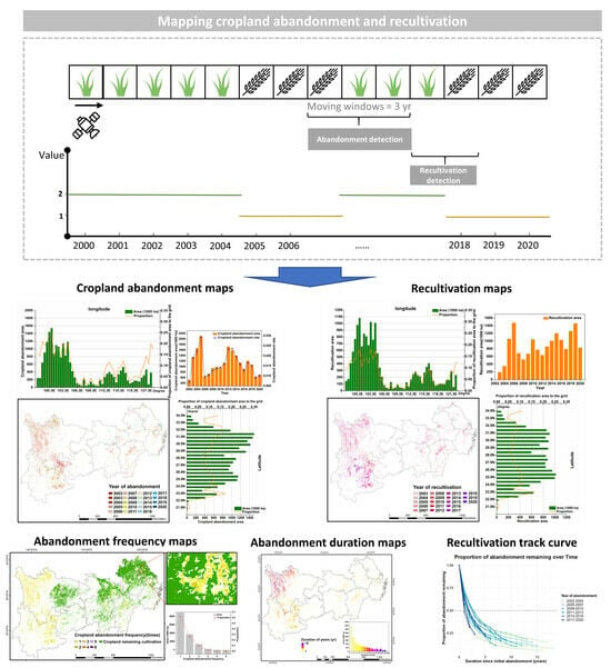
- We mapped the extent and timing of cropland abandonment and recultivation based on continuous time series land cover data.
- (3)
- We analyzed the cropland abandonment intensity (i.e., frequency and duration) and the spatial and temporal interaction with recultivation.
2. Materials and Methods
2.1. Study Areas
2.2. Definition of Cropland Abandonment and Recultivation
2.3. Data Preprocessing for Classification
2.4. Annual Land Cover Map** and Accuracy Assessment

| Year | GlobeLand30 | CNLUCC | MCD12Q1 | ESA-CCI | GlobCover |
|---|---|---|---|---|---|
| 2000 | 2000 | 2000 | 2001 | 2000 | |
| 2001 | 2000 | 2000 | 2001 | 2001 | |
| 2002 | 2000 | 2000 | 2002 | 2002 | |
| 2003 | 2005 | 2003 | 2003 | 2005 | |
| 2004 | 2005 | 2004 | 2004 | 2005 | |
| 2005 | 2005 | 2005 | 2005 | 2005 | |
| 2006 | 2005 | 2006 | 2006 | 2005 | |
| 2007 | 2005 | 2007 | 2007 | 2005 | |
| 2008 | 2010 | 2010 | 2008 | 2008 | 2009 |
| 2009 | 2010 | 2010 | 2009 | 2009 | 2009 |
| 2010 | 2010 | 2010 | 2010 | 2010 | |
| 2011 | 2010 | 2010 | 2011 | 2011 | |
| 2012 | 2010 | 2010 | 2012 | 2012 | |
| 2013 | 2015 | 2013 | 2013 | ||
| 2014 | 2015 | 2014 | 2014 | ||
| 2015 | 2015 | 2015 | 2015 | ||
| 2016 | 2015 | 2016 | 2015 | ||
| 2017 | 2018 | 2017 | 2015 | ||
| 2018 | 2020 | 2018 | 2018 | ||
| 2019 | 2020 | 2018 | 2019 | ||
| 2020 | 2020 | 2020 | 2019 |
2.5. Annual Cropland Abandonment and Recultivation Map**
3. Results
3.1. Land Cover Maps and Accuracy
3.2. Spatiotemporal Analysis of Cropland Abandonment
3.3. Spatiotemporal Analysis of Recultivation
4. Discussion
4.1. Comparison with Other Studies
4.2. Cropland Abandonment and Recultivation Drivers
4.3. Policy Implications
4.4. Limitations and Future Perspectives
5. Conclusions
Supplementary Materials
Author Contributions
Funding
Data Availability Statement
Acknowledgments
Conflicts of Interest
References
- Foley, J.A.; Ramankutty, N.; Brauman, K.A.; Cassidy, E.S.; Gerber, J.S.; Johnston, M.; Mueller, N.D.; O’Connell, C.; Ray, D.K.; West, P.C.; et al. Solutions for a cultivated planet. Nature 2011, 478, 337–342. [Google Scholar] [CrossRef]
- Lambin, E.F.; Meyfroidt, P. Global land use change, economic globalization, and the looming land scarcity. Proc. Natl. Acad. Sci. USA 2011, 108, 3465–3472. [Google Scholar] [CrossRef]
- Chazdon, R.L.; Lindenmayer, D.; Guariguata, M.R.; Crouzeilles, R.; Rey Benayas, J.M.; Lazos Chavero, E. Fostering natural forest regeneration on former agricultural land through economic and policy interventions. Environ. Res. Lett. 2020, 15, 043002. [Google Scholar] [CrossRef]
- Winkler, K.; Fuchs, R.; Rounsevell, M.; Herold, M. Global land use changes are four times greater than previously estimated. Nat. Commun. 2021, 12, 2501. [Google Scholar] [CrossRef]
- Ramankutty, N.; Mehrabi, Z.; Waha, K.; Jarvis, L.; Kremen, C.; Herrero, M.; Rieseberg, L.H. Trends in Global Agricultural Land Use: Implications for Environmental Health and Food Security. Annu. Rev. Plant Biol. 2018, 69, 789–815. [Google Scholar] [CrossRef]
- Potapov, P.; Turubanova, S.; Hansen, M.C.; Tyukavina, A.; Zalles, V.; Khan, A.; Song, X.P.; Pickens, A.; Shen, Q.; Cortez, J. Global maps of cropland extent and change show accelerated cropland expansion in the twenty-first century. Nature Food 2022, 3, 19–28. [Google Scholar] [CrossRef]
- Estel, S.; Kuemmerle, T.; Alcántara, C.; Levers, C.; Prishchepov, A.; Hostert, P. Map** farmland abandonment and recultivation across Europe using MODIS NDVI time series. Remote Sens. Environ. 2015, 163, 312–325. [Google Scholar] [CrossRef]
- Yu, Z.; Lu, C. Historical cropland expansion and abandonment in the continental U.S. during 1850 to 2016. Glob. Ecol. Biogeogr. 2018, 27, 322–333. [Google Scholar] [CrossRef]
- Yoon, H.; Kim, S. Detecting abandoned farmland using harmonic analysis and machine learning. ISPRS J. Photogramm. Remote Sens. 2020, 166, 201–212. [Google Scholar] [CrossRef]
- Zhu, X.; ** abandoned farmland in China using time series MODIS NDVI. Sci. Total Environ. 2021, 755, 142651. [Google Scholar] [CrossRef]
- Kolecka, N. Height of Successional Vegetation Indicates Moment of Agricultural Land Abandonment. Remote Sens. 2018, 10, 1568. [Google Scholar] [CrossRef]
- Bell, S.M.; Raymond, S.J.; Yin, H.; Jiao, W.; Goll, D.S.; Ciais, P.; Olivetti, E.; Leshyk, V.O.; Terrer, C. Quantifying the recarbonization of post-agricultural landscapes. Nat. Commun. 2023, 14, 2139. [Google Scholar] [CrossRef]
- Li, L.; Pan, Y.; Zheng, R.; Liu, X. Understanding the spatiotemporal patterns of seasonal, annual, and consecutive farmland abandonment in China with time-series MODIS images during the period 2005–2019. Land Degrad. Dev. 2022, 33, 1608–1625. [Google Scholar] [CrossRef]
- Prishchepov, A.V.; Ponkina, E.V.; Sun, Z.; Bavorova, M.; Yekimovskaja, O.A. Revealing the intentions of farmers to recultivate abandoned farmland: A case study of the Buryat Republic in Russia. Land Use Policy 2021, 107, 105513. [Google Scholar] [CrossRef]
- Alix-Garcia, J.; Kuemmerle, T.; Radeloff, V.C. Prices, land tenure institutions, and geography: A matching analysis of farmland abandonment in post-socialist Eastern Europe. Land Econ. 2012, 88, 425–443. [Google Scholar] [CrossRef]
- Xu, D.; Deng, X.; Guo, S.; Liu, S. Labor migration and farmland abandonment in rural China: Empirical results and policy implications. J. Environ. Manag. 2019, 232, 738–750. [Google Scholar] [CrossRef]
- Goga, T.; Feranec, J.; Bucha, T.; Rusnák, M.; Sačkov, I.; Barka, I.; Kopecká, M.; Papčo, J.; Oťaheľ, J.; Szatmári, D. A review of the application of Remote Sens. data for abandoned agricultural land identification with focus on Central and Eastern Europe. Remote Sens. 2019, 11, 2759. [Google Scholar] [CrossRef]
- Oliphant, A.J.; Thenkabail, P.S.; Teluguntla, P.; ** cropland extent of Southeast and Northeast Asia using multi-year time-series Landsat 30-m data using a random forest classifier on the Google Earth Engine Cloud. Int. J. Appl. Earth Observ. Geoinform. 2019, 81, 110–124. [Google Scholar] [CrossRef]
- Cao, R.; Chen, Y.; Chen, J.; Zhu, X.; Shen, M. Thick cloud removal in Landsat images based on autoregression of Landsat time-series data. Remote Sens. Environ. 2020, 249, 112001. [Google Scholar] [CrossRef]
- Pointereau, P.; Coulon, F.; Girard, P.; Lambotte, M.; Rio, A.D. Analysis of Farmland Abandonment and the Extent and Location of Agricultural Areas that are Actually Abandoned or are in Risk to be Abandoned; Dictus Publishing: Riga, Latvia, 2008. [Google Scholar]
- FAO. Available online: http://www.fao.org/ag/agn/nutrition/Indicatorsfiles/Agriculture.pdf (accessed on 10 November 2022).
- Löw, F.; Fliemann, E.; Abdullaev, I.; Conrad, C.; Lamers, J.P.A. Map** abandoned agricultural land in Kyzyl-Orda, Kazakhstan using satellite Remote Sensing. Appl. Geogr. 2015, 62, 377–390. [Google Scholar] [CrossRef]
- Löw, F.; Prishchepov, A.; Waldner, F.; Dubovyk, O.; Akramkhanov, A.; Biradar, C.; Lamers, J. Map** Cropland Abandonment in the Aral Sea Basin with MODIS Time Series. Remote Sens. 2018, 10, 159. [Google Scholar] [CrossRef]
- Fensholt, R.; Horion, S.; Tagesson, T.; Ehammer, A.; Grogan, K.; Tian, F.; Huber, S.; Verbesselt, J.; Prince, S.D.; Tucker, C.J. Assessment of vegetation trends in drylands from time series of earth observation data. In Remote Sensing Time Series. Remote Sensing and Digital Image Processing; Springer: Cham, Switzerland, 2015; pp. 159–182. [Google Scholar] [CrossRef]
- Han, Z.; Song, W. Spatiotemporal variations in cropland abandonment in the Guizhou–Guangxi karst mountain area, China. J. Clean. Prod. 2019, 238, 117888. [Google Scholar] [CrossRef]
- Luo, K.; Moiwo, J.P. Rapid monitoring of abandoned farmland and information on regulation achievements of government based on Remote Sens. technology. Environ. Sci. Policy 2022, 132, 91–100. [Google Scholar] [CrossRef]
- Fritz, S.; McCallum, I.; Schill, C.; Perger, C.; See, L.; Schepaschenko, D.; van der Velde, M.; Kraxner, F.; Obersteiner, M. Geo-Wiki: An online platform for improving global land cover. Environ. Model. Softw. 2012, 31, 110–123. [Google Scholar] [CrossRef]
- Tong, X.; Brandt, M.; Hiernaux, P.; Herrmann, S.; Rasmussen, L.V.; Rasmussen, K.; Tian, F.; Tagesson, T.; Zhang, W.; Fensholt, R. The forgotten land use class: Map** of fallow fields across the Sahel using Sentinel-2. Remote Sens. Environ. 2020, 239, 111598. [Google Scholar] [CrossRef]
- Li, C.; **. Remote Sens. Environ. 2021, 266, 112670. [ISPRS J. Photogramm. Remote Sens. 2020, 159, 337–351. [Google Scholar] [CrossRef]
- Li, C.; Yao, J.; Li, R.; Zhu, Y.; Yao, H.; Zhang, P.; Wei, D.; Zhao, S.; Li, Y.; Wu, Y. “3S” Technologies and Application for Dynamic Monitoring Soil and Water Loss in the Yangtze River Basin, China. Int. Arch. Photogramm. Remote Sens. Spat. Inf. Sci. 2020, 43, 1563–1567. [Google Scholar] [CrossRef]
- Jiang, L.; Wu, S.; Liu, Y. Change analysis on the spatio-temporal patterns of main crop planting in the middle yangtze plain. Remote Sens. 2022, 14, 1141. [Google Scholar] [CrossRef]
- Dong, S.; ** agricultural land-use? Unraveling the nexus between farmland abandonment and urbanization in China. Landsc. Urban Plan. 2021, 214, 104170. [Google Scholar] [CrossRef]
- Zhou, Y.; Li, X.; Liu, Y. Land use change and driving factors in rural China during the period 1995-2015. Land Use Policy 2020, 99, 105048. [Google Scholar] [CrossRef]
- GrĂDinaru, S.R.; IojĂ, C.I.; VÂNĂU, G.O.; Onose, D.A. Multi-Dimensionality of Land Transformations: From Definition to Perspectives on Land Abandonment. Carpathian J. Earth Environ. Sci. 2020, 15, 167–177. [Google Scholar] [CrossRef]
- He, H.; Ma, Y. Imbalanced Learning; The Institute of Electrical and Electronics Engineers, Inc.: Piscataway, NJ, USA, 2013. [Google Scholar]
- Powers, D. Evaluation, from precision, recall and F-measure to ROC, informedness, markedness and correlation. J. Mach. Learn. Tech. 2011, 2, 37–63. [Google Scholar] [CrossRef]
- Zhao, Y.; Zhu, W.; Wei, P.; Fang, P.; Zhang, X.; Yan, N.; Liu, W.; Zhao, H.; Wu, Q. Classification of Zambian grasslands using random forest feature importance selection during the optimal phenological period. Ecol. Indic. 2022, 135, 108529. [Google Scholar] [CrossRef]
- Yang, Y.; ** at national scales with Google Earth Engine. Remote Sens. Environ. 2019, 228, 115–128. [Google Scholar] [CrossRef]
- Tamiminia, H.; Salehi, B.; Mahdianpari, M.; Quackenbush, L.; Adeli, S.; Brisco, B. Google Earth Engine for geo-big data applications: A meta-analysis and systematic review. ISPRS J. Photogramm. Remote Sens. 2020, 164, 152–170. [Google Scholar] [CrossRef]
- Ghimire, B.; Rogan, J.; Galiano, V.R.; Panday, P.; Neeti, N. An evaluation of bagging, boosting, and random forests for land-cover classification in Cape Cod, Massachusetts, USA. GIScience Remote Sens. 2012, 49, 623–643. [Google Scholar] [CrossRef]
- Long, H.L.; Heilig, G.K.; Wang, J.; Li, X.B.; Luo, M.; Wu, X.Q.; Zhang, M. Land use and soil erosion in the upper reaches of the Yangtze River: Some socio-economic considerations on China’s Grain-for-Green Programme. Land Degrad. Dev. 2006, 17, 589–603. [Google Scholar] [CrossRef]
- Hong, C.; Prishchepov, A.V.; **, X.; Zhou, Y. Map** cropland abandonment and distinguishing from intentional afforestation with Landsat time series. Int. J. Appl. Earth Observ. Geoinform. 2024, 127, 103693. [Google Scholar] [CrossRef]
- Yang, J.; Huang, X. The 30 m annual land cover dataset and its dynamics in China from 1990 to 2019. Earth System Sci. Data 2021, 13, 3907–3925. [Google Scholar] [CrossRef]
- Prishchepov, A.V.; Radeloff, V.C.; Baumann, M.; Kuemmerle, T.; Müller, D. Effects of institutional changes on land use: Agricultural land abandonment during the transition from state-command to market-driven economies in post-Soviet Eastern Europe. Environ. Res. Lett. 2012, 7, 024021. [Google Scholar] [CrossRef]
- Jiang, Y.; He, X.; Yin, X.; Chen, F. The pattern of abandoned cropland and its productivity potential in China: A four-years continuous study. Sci. Total Environ. 2023, 870, 161928. [Google Scholar] [CrossRef]
- Rodrigo-Comino, J.; Martínez-Hernández, C.; Iserloh, T.; Cerda, A. Contrasted impact of land abandonment on soil erosion in Mediterranean agriculture fields. Pedosphere 2018, 28, 617–631. [Google Scholar] [CrossRef]
- Ustaoglu, E.; Collier, M.J. Farmland abandonment in Europe: An overview of drivers, consequences, and assessment of the sustainability implications. Environ. Rev. 2018, 26, 396–416. [Google Scholar] [CrossRef]
- Fayet, C.M.; Reilly, K.H.; Van Ham, C.; Verburg, P.H. What is the future of abandoned agricultural lands? A systematic review of alternative trajectories in Europe. Land Use Policy 2022, 112, 105833. [Google Scholar] [CrossRef]
- Fayet, C.M.; Reilly, K.H.; Van Ham, C.; Verburg, P.H. The potential of European abandoned agricultural lands to contribute to the Green Deal objectives: Policy perspectives. Environ. Sci. Policy 2022, 133, 44–53. [Google Scholar] [CrossRef]
- Zhang, M.; Li, G.; He, T.; Zhai, G.; Guo, A.; Chen, H.; Wu, C. Reveal the severe spatial and temporal patterns of abandoned cropland in China over the past 30 years. Sci. Total Environ. 2023, 857, 159591. [Google Scholar] [CrossRef]
- Li, S.; Li, X.; Sun, L.; Cao, G.; Fischer, G.; Tramberend, S. An estimation of the extent of cropland abandonment in mountainous regions of China. Land Degrad. Dev. 2018, 29, 1327–1342. [Google Scholar] [CrossRef]
- Dara, A.; Baumann, M.; Kuemmerle, T.; Pflugmacher, D.; Rabe, A.; Griffiths, P.; Hölzel, N.; Kamp, J.; Freitag, M.; Hostert, P. Map** the timing of cropland abandonment and recultivation in northern Kazakhstan using annual Landsat time series. Remote Sens. Environ. 2018, 213, 49–60. [Google Scholar] [CrossRef]
- Crawford, C.L.; Yin, H.; Radeloff, V.C.; Wilcove, D.S. Rural land abandonment is too ephemeral to provide major benefits for biodiversity and climate. Sci. Adv. 2022, 8, eabm8999. [Google Scholar] [CrossRef] [PubMed]
- Song, W. Map** cropland abandonment in mountainous areas using an annual land-use trajectory approach. Sustainability 2019, 11, 5951. [Google Scholar] [CrossRef]
- Chazdon, R.L.; Broadbent, E.N.; Rozendaal, D.M.; Bongers, F.; Zambrano, A.M.A.; Aide, T.M.; Balvanera, P.; Becknell, J.M.; Boukili, V.; Brancalion, P.H. Carbon sequestration potential of second-growth forest regeneration in the Latin American tropics. Sci. Adv. 2016, 2, e1501639. [Google Scholar] [CrossRef] [PubMed]
- Schwartz, N.B.; Aide, T.M.; Graesser, J.; Grau, H.R.; Uriarte, M. Reversals of reforestation across Latin America limit climate mitigation potential of tropical forests. Front. For. Glob. Chang. 2020, 3, 85. [Google Scholar] [CrossRef]
- Nunes, S.; Oliveira, L.; Siqueira, J.; Morton, D.C.; Souza, C.M. Unmasking secondary vegetation dynamics in the Brazilian Amazon. Environ. Res. Lett. 2020, 15, 034057. [Google Scholar] [CrossRef]
- Smith, C.C.; Espírito-Santo, F.D.; Healey, J.R.; Young, P.J.; Lennox, G.D.; Ferreira, J.; Barlow, J. Secondary forests offset less than 10% of deforestation-mediated carbon emissions in the Brazilian Amazon. Glob. Chang. Biol. 2020, 26, 7006–7020. [Google Scholar] [CrossRef] [PubMed]
- Wang, X.; Shen, Y. The effect of China’s agricultural tax abolition on rural families’ incomes and production. China Econ. Rev. 2014, 29, 185–199. [Google Scholar] [CrossRef]
- Levers, C.; Schneider, M.; Prishchepov, A.V.; Estel, S.; Kuemmerle, T. Spatial variation in determinants of agricultural land abandonment in Europe. Sci. Total Environ. 2018, 644, 95–111. [Google Scholar] [CrossRef] [PubMed]
- Rigg, J.; Salamanca, A.; Phongsiri, M.; Sripun, M. More farmers, less farming? Understanding the truncated agrarian transition in Thailand. World Dev. 2018, 107, 327–337. [Google Scholar] [CrossRef]
- Long, Y.; Wu, W.; Hu, Q.; Chen, D.; ** Index of Farmland and Regional Optimization Scheme in China Based on NDVI Data. Land 2021, 10, 861. [Google Scholar] [CrossRef]
- Liu, Z.; Liang, H.; Pu, D.; ** using MODIS-based automated cropland classification algorithm. J. Appl. Remote Sens. 2014, 8, 083685. [Google Scholar] [CrossRef]
- Gong, P.; Wang, J.; Yu, L.; Zhao, Y.; Zhao, Y.; Liang, L.; Niu, Z.; Huang, X.; Fu, H.; Liu, S.; et al. Finer resolution observation and monitoring of global land cover: First map** results with Landsat TM and ETM+ data. Int. J. Remote Sens. 2012, 34, 2607–2654. [Google Scholar] [CrossRef]
- Vicenteserrano, S.; Perezcabello, F.; Lasanta, T. Assessment of radiometric correction techniques in analyzing vegetation variability and change using time series of Landsat images. Remote Sens. Environ. 2008, 112, 3916–3934. [Google Scholar] [CrossRef]
- Heidarian Dehkordi, R.; Pelgrum, H.; Meersmans, J. High spatio-temporal monitoring of century-old biochar effects on evapotranspiration through the ETLook model: A case study with UAV and satellite image fusion based on additive wavelet transform (AWT). GIScience Remote Sens. 2021, 59, 111–141. [Google Scholar] [CrossRef]
- Zhu, X.; Chen, J.; Gao, F.; Chen, X.; Masek, J.G. An enhanced spatial and temporal adaptive reflectance fusion model for complex heterogeneous regions. Remote Sens. Environ. 2010, 114, 2610–2623. [Google Scholar] [CrossRef]
- Kassam, A.; Friedrich, T.; Derpsch, R. Global spread of Conservation Agriculture. Int. J. Environ. Stud. 2018, 76, 29–51. [Google Scholar] [CrossRef]
- Zhang, H.; Zhang, J.; Song, J. Analysis of the threshold effect of agricultural industrial agglomeration and industrial structure upgrading on sustainable agricultural development in China. J. Clean. Prod. 2022, 341, 130818. [Google Scholar] [CrossRef]
- Munroe, D.K.; van Berkel, D.B.; Verburg, P.H.; Olson, J.L. Alternative trajectories of land abandonment: Causes, consequences and research challenges. Curr. Opin. Environ. Sustain. 2013, 5, 471–476. [Google Scholar] [CrossRef]
- Poorter, L.; Bongers, F.; Aide, T.M.; Almeyda Zambrano, A.M.; Balvanera, P.; Becknell, J.M.; Boukili, V.; Brancalion, P.H.; Broadbent, E.N.; Chazdon, R.L. Biomass resilience of Neotropical secondary forests. Nature 2016, 530, 211–214. [Google Scholar] [CrossRef] [PubMed]
- Prach, K.; Walker, L.R. Four opportunities for studies of ecological succession. Trends Ecol. Evol. 2011, 26, 119–123. [Google Scholar] [CrossRef] [PubMed]


Disclaimer/Publisher’s Note: The statements, opinions and data contained in all publications are solely those of the individual author(s) and contributor(s) and not of MDPI and/or the editor(s). MDPI and/or the editor(s) disclaim responsibility for any injury to people or property resulting from any ideas, methods, instructions or products referred to in the content. |
© 2024 by the authors. Licensee MDPI, Basel, Switzerland. This article is an open access article distributed under the terms and conditions of the Creative Commons Attribution (CC BY) license (https://creativecommons.org/licenses/by/4.0/).
Share and Cite
Long, Y.; Sun, J.; Wellens, J.; Colinet, G.; Wu, W.; Meersmans, J. Map** the Spatiotemporal Dynamics of Cropland Abandonment and Recultivation across the Yangtze River Basin. Remote Sens. 2024, 16, 1052. https://doi.org/10.3390/rs16061052
Long Y, Sun J, Wellens J, Colinet G, Wu W, Meersmans J. Map** the Spatiotemporal Dynamics of Cropland Abandonment and Recultivation across the Yangtze River Basin. Remote Sensing. 2024; 16(6):1052. https://doi.org/10.3390/rs16061052
Chicago/Turabian StyleLong, Yuqiao, **g Sun, Joost Wellens, Gilles Colinet, Wenbin Wu, and Jeroen Meersmans. 2024. "Map** the Spatiotemporal Dynamics of Cropland Abandonment and Recultivation across the Yangtze River Basin" Remote Sensing 16, no. 6: 1052. https://doi.org/10.3390/rs16061052