1. Introduction
Over the last decades, Burkina Faso has undergone considerable changes. Since the year 2000, the population grew by about 56% from 11.6 million to 18.1 million people in 2015 [
1]. Burkina Faso still ranks among the least developed countries in the world (Human Development Index, HDR = 0.402, rank 183 of 188 countries, [
2]), even though the gross domestic product (GDP) exhibited a sustained growth during recent years with a plus of 6.7% in 2013 [
3,
4]. Since the economy is relatively undiversified and relies heavily on rainfed agricultural production, the country is highly vulnerable to climatic and economic shocks such as droughts, international market price fluctuations or political instability [
4,
5]. Thus, poverty, especially in rural areas, still prevails, and with a rapidly growing population also the number of undernourished people increased in recent years [
4]. Despite the fact that the country is said to have a high agricultural potential [
6,
7] and more than 90% of the country’s labor force is working in the agricultural sector, the crop productivity per hectare did not rise considerably during the last 50 years [
1]. Thus in order to improve the situation in Burkina Faso, amongst others agricultural systems food security must be further developed.
Agriculture in Burkina Faso is characterized by small-scale rainfed subsistence farming with average farm sizes of less than 5 ha [
8]. The lack of own capital and access to credits results in extensive farming as characterized by a low level of agricultural inputs, mechanization, fertilizer application, as well as irrigation [
4,
5]. With a rapidly increasing population and little improvement in agricultural productivity, farmers compensate by expanding cultivated area. As a consequence, it is estimated that the country will reach its limits of arable land by the year 2030 [
5]. Furthermore, this expansion also threatens natural resources, and the pressure on the last remnants of natural vegetation is increasing [
9]. In order to capture the whole anthropogenic need of space for agricultural production, (rainfed) agricultural area is defined here as farmed land with partial tree cover (<10%, potentially fruit trees) including the prevailing crop-fallow rotation system of annual crops and intensive pasture, i.e., shrub-free, partially fenced areas frequently used for grazing.
Even though accurate spatial documentation of the past and current extent of agricultural areas is essential information for decision makers, such information is currently missing. For Burkina Faso, statistical data on cropped area exist which are derived from household surveys conducted by the National Ministry of Agriculture, Water and Fishery Resources but these are of varying quality and only available at province level [
10]. Agricultural extent can be deduced from global land cover maps such as the 500 m MODIS (Moderate Resolution Imaging Spectroradiometer) product MCD12Q1 [
11], the 300 m ESA CCI (European Space Agency, Climate Change Initiative) land cover product [
12] or the Chinese 30 m products FROM-GLC (Finer Resolution Observation and Monitoring of Global Land Cover) and GLOBELAND30 [
13,
14]. However, the usability of this data is often limited for detailed regional scale applications due to low spatial resolution, missing thematic complexity, temporal availability or regional accuracy [
15,
16,
17]. Regionally optimized land cover information for West Africa based on moderate resolution (250 m) remote sensing data [
15] give a good overview of the distribution of agriculture in Burkina Faso. Nonetheless, they face difficulties in the discrimination of small-scale agriculture from natural vegetation classes and are so far not available for recent years. Lambert et al. [
18] derived croplands from 100 m PROBA-V data for the Sudanian and Sahelian region of West Africa for the year 2014. This interesting approach however is also struggling with some spatial resolution based errors in heterogeneous areas. Furthermore, high to medium resolution (5–30 m) remote sensing based land cover maps exist which are regionally optimized but they only cover small parts of the country [
9,
19,
20,
21].
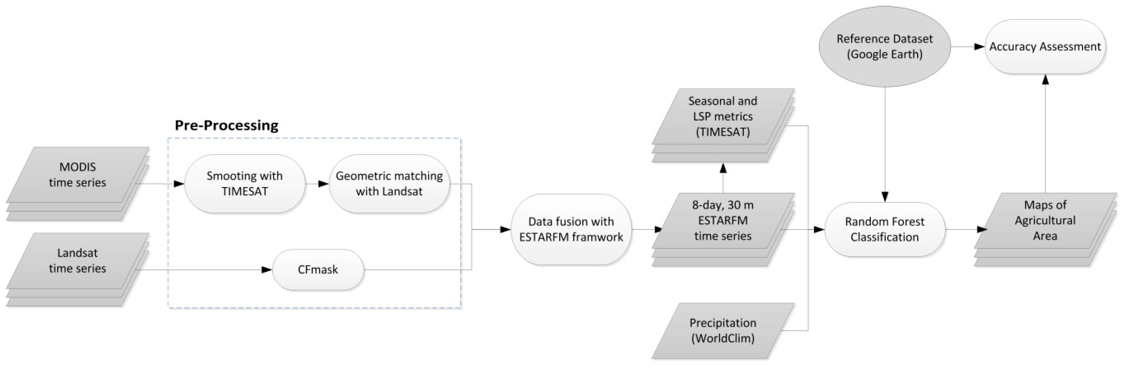
In general, remote sensing is a highly suitable tool for large scale and cost efficient map** of agricultural area. However, remote sensing based monitoring of the spatio-temporal development of agriculture in Burkina Faso and Africa in general is a challenging task. The above described small-scale extensive farming systems require high temporal and spatial resolution data for an accurate delineation. Landsat data may have a sufficient spatial resolution (30 m) to capture single fields but due to frequent cloud cover [
22] and limited data availability for West Africa during the past decades (Landsat-5 and Landsat-7), gap-free coverage of the country is mainly limited to the dry season when the agricultural area is difficult to delineate from other natural land cover types. Because of its high temporal resolution and its globally uniform acquisition scheme, the MODIS sensors deliver data more continuously but the spatial resolution of 250 m or less is not satisfactory to delimit small-scale agricultural areas [
23]. Thus, in this study, a data fusion approach was chosen to combine the strengths of the two sensor systems (MODIS and Landsat) and to generate a high temporal (8-day) and high spatial (30 m) resolution time series for a better delineation of agricultural area in Burkina Faso. For this purpose, the ESTARFM (Enhanced Spatial and Temporal Adaptive Reflectance Fusion Model) framework for large- and cloud-prone area processing was employed [
24,
25].
The goals of this study are to derive high spatial (30 m) resolution information of agricultural area for entire Burkina Faso for the years 2001, 2007, and 2014. Based on these maps, the spatio-temporal development of the major food-producing land use types (rainfed agricultural area, irrigated agricultural area and plantations) is identified. Furthermore, the connection between agricultural expansion and population growth and the regional differences within Burkina Faso are outlined. Finally, the influence of agricultural expansion on natural reserves with different protection status is examined with a buffer analysis for selected protected areas and their surroundings.
2. Study Area
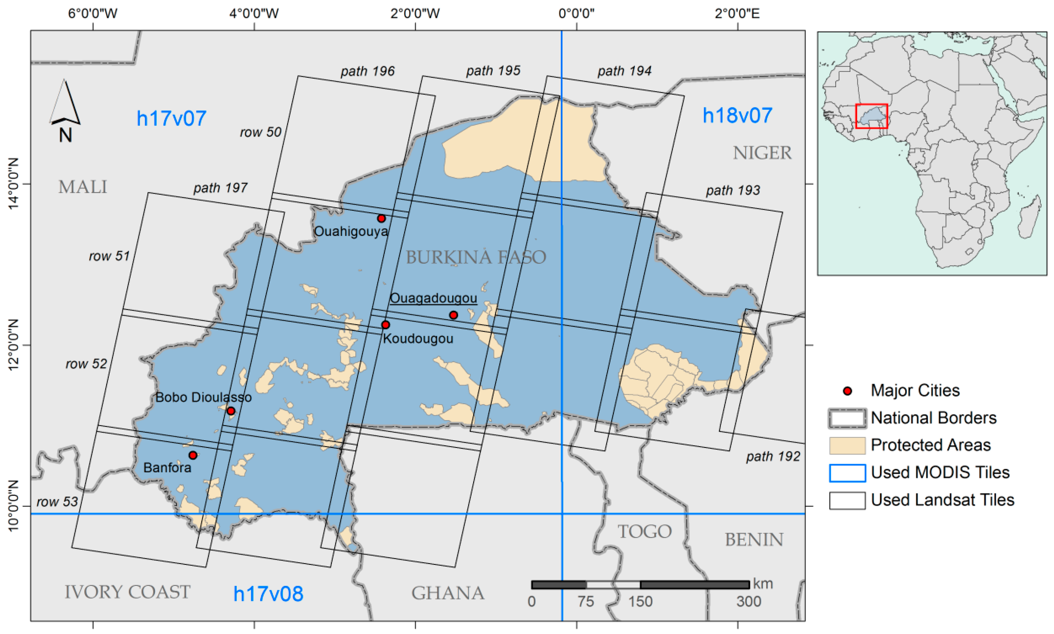
Burkina Faso is a landlocked country in the center of West Africa with a size of approx. 274,000 km² (
Figure 1). The climate is characterized by a North-South moisture gradient and mainly influenced by the interaction between the West African Monsoon bringing rainfalls from the Southwest during the rainy season and the Harmattan blowing hot winds from the North during the dry season. The annual rainfall ranges from less than 300 mm in the North to more than 1100 mm in the South with distinct rainy and dry seasons. The rainy season occurs between May and October for four to five months with shorter duration in the North [
26,
27]. The mean monthly temperatures range between 23 °C and 34 °C in the North and 25–31 °C in the South [
28].
The northern part of Burkina Faso is located in the Sahel zone or Sahelian Acacia Savanna. The natural vegetation of this area predominantly consists of wooded grassland and deciduous shrubland with a sparse tree layer [
29]. The southern part of the country is located in the West Sudanian savanna; its natural vegetation is characterized by a more dense deciduous shrubland and woodland and is known for its high agricultural potential [
7,
30,
31].
The major staple crops in Burkina Faso are maize, millet and sorghum while cotton is the most important agricultural export commodity [
1,
4]. Some irrigated areas of minor extent can be found mainly in the direct vicinity of dammed lakes. In the southwest of Burkina Faso, especially around the city of Banfora, plantations of fruit trees such as mango and citrus fruits as well as nut trees (e.g., cashew and shea nuts) are located [
32,
33]. In recent years, these plantation products experienced a considerable rise in production and export value (compare
Section 4.1.1) [
34].
The overall number of inhabitants in Burkina Faso has increased significantly during recent years, from about 12 million in 2001 to more than 17 million people in 2014 [
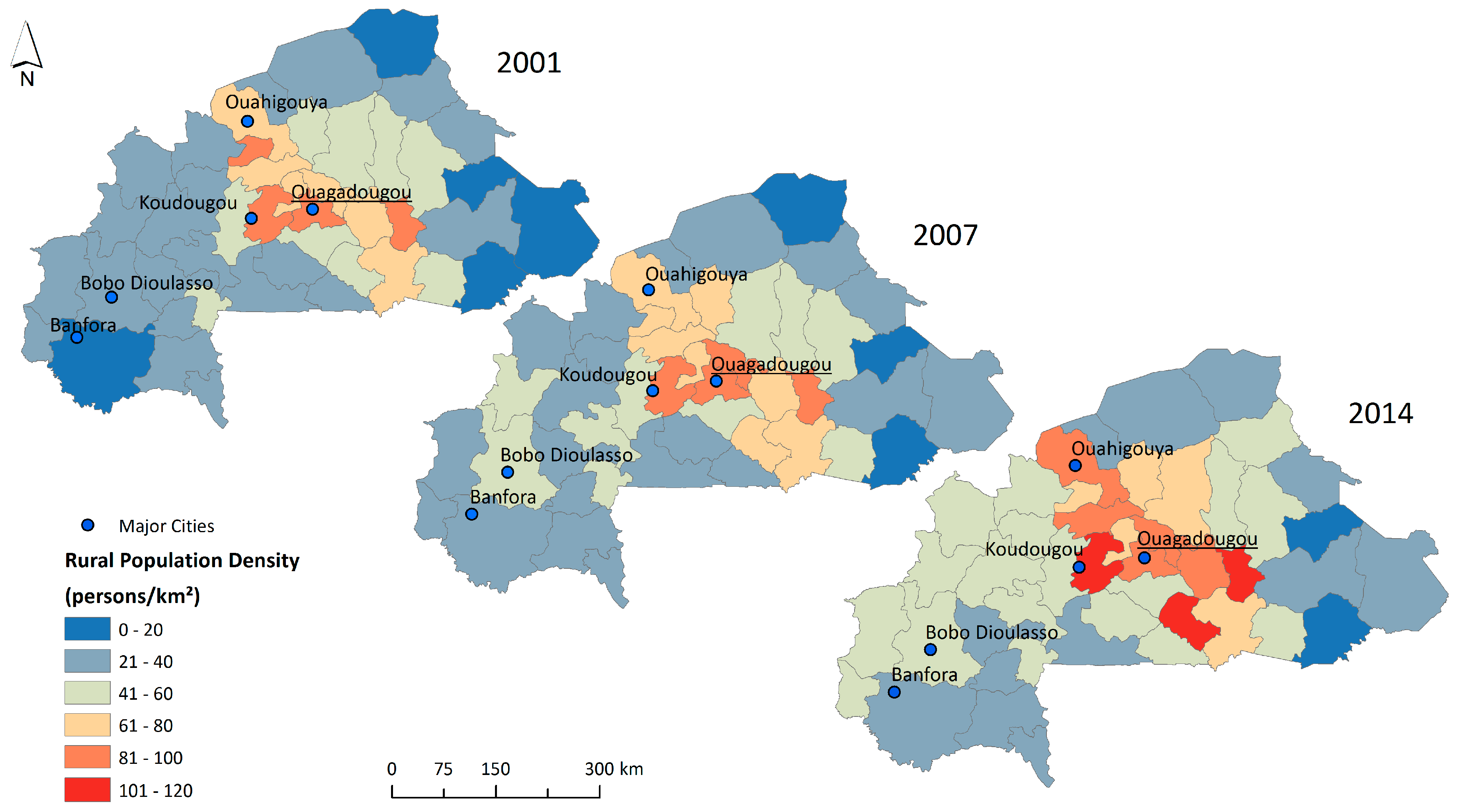
1]. The rural population, which predominantly works in the agricultural sector, is concentrated in the central provinces around the capital of Ouagadougou (
Figure 2). Since 2001, the rural population increased in most parts of the country, even in the remote, northern provinces bordering the Sahara [
35].
4. Results
The results are presented in three major sections: first, the novel Burkina Faso wide high resolution agricultural classifications are shown and regional differences and developments of agricultural patterns are highlighted giving examples of plantations, as well as rainfed and irrigated agricultural area. Then, the implications of agricultural expansion for protected areas are exemplarily analyzed and outlined based on two focus regions. Lastly, the link between agricultural area expansion and rural population increase is highlighted. In the following sections, the agricultural classification of 2007 is only used and presented for focus regions since it does not cover the whole country due to a lack of Landsat input data as described in
Section 3.1.
4.1. Agricultural Area in Burkina Faso between 2001 and 2014
The extent of agricultural area at a 30 m spatial resolution for the years 2001 and 2014 can be seen in
Figure 4. In 2001, rainfed agricultural area covers about 60,441 km² which corresponds to 22% of Burkina Faso’s land surface (
Table 3). It is mainly accumulated in the central area around the capital Ouagadougou and in the regions southeast of it. The more remote areas such as the northern Sahel region, the East bordering Nigeria and Niger as well as the moist southwestern regions were for the major part not cultivated in 2001. With an approximate extent of 561 km² in 2001, almost all of the plantations are established in these southwestern regions where the climate is more humid and the rainfalls are highest. In terms of size, the irrigated areas only play a minor role (about 78 km²) and are mainly located around the water reservoirs in the same regions as the rainfed agricultural areas.
Between 2001 and 2014, the rainfed agricultural area increased by about 90% to 114,994 km² and now covers about 42% of the country area. While the already densely cultivated central region of Burkina Faso only marginally expanded its rainfed agricultural area, it spread into all parts of the country, also into the above mentioned remote areas. The plantation area in 2014 almost tripled to 1568 km² and two main regions are clearly visible: one is located in the northwest of the city of Banfora, mostly in the provinces Kénédougou and Léraba, and one is situated in the southeast of Banfora, in the provinces Comoé and Poni. With an increasing number of water reservoirs, also the irrigated area expanded significantly by about 340% although the total number of 345 km² is still low in comparison to the other forms of agriculture.
The overall accuracies for the three classified years are 92% for 2001, 91% for 2007, and 91% for 2014, and can be investigated in
Table 4 including class-specific user’s and producer’s accuracies. While rainfed agricultural area displays user’s and producer’s accuracies of more than 80% for all three years, irrigated agriculture shows some underestimation and thus lower producer’s accuracies for the years 2007 and 2014 due to some confusion with temporarily flooded vegetation. For plantation areas, the user’s and producer’s accuracies range between 77% and 97%. Some overestimations occur along rivers confusing plantation with gallery forests.
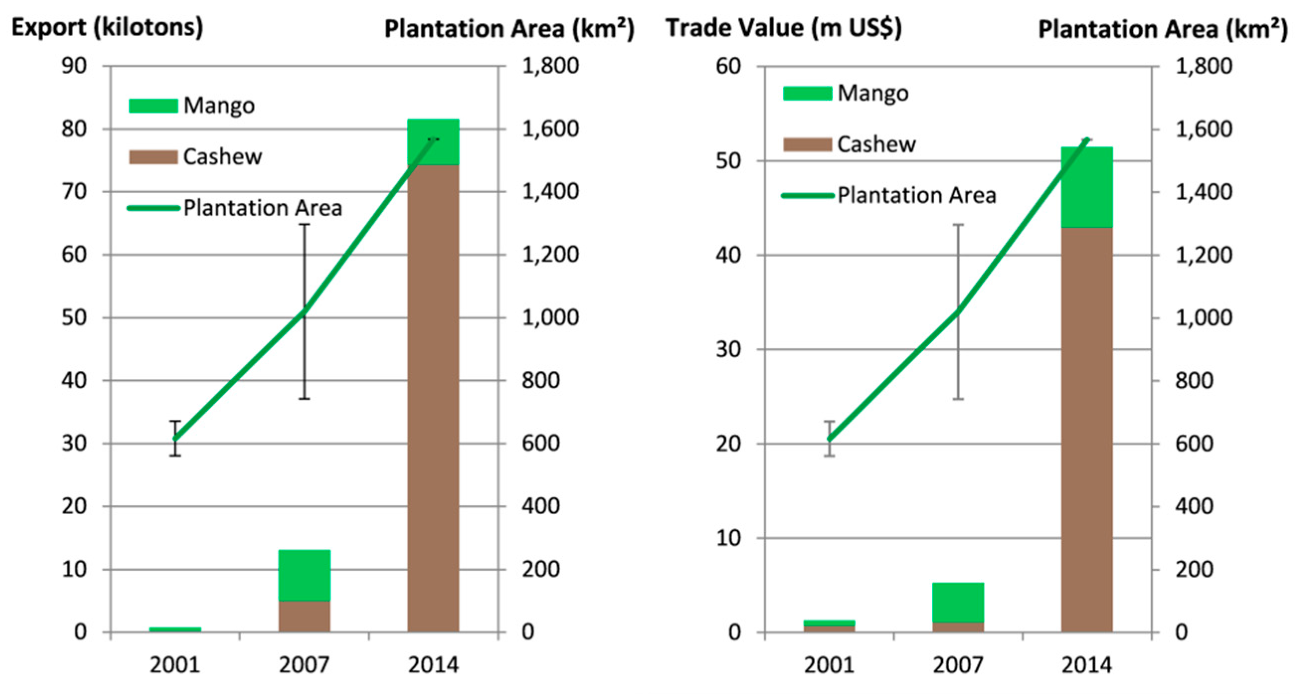
4.1.1. Development of Plantation Area
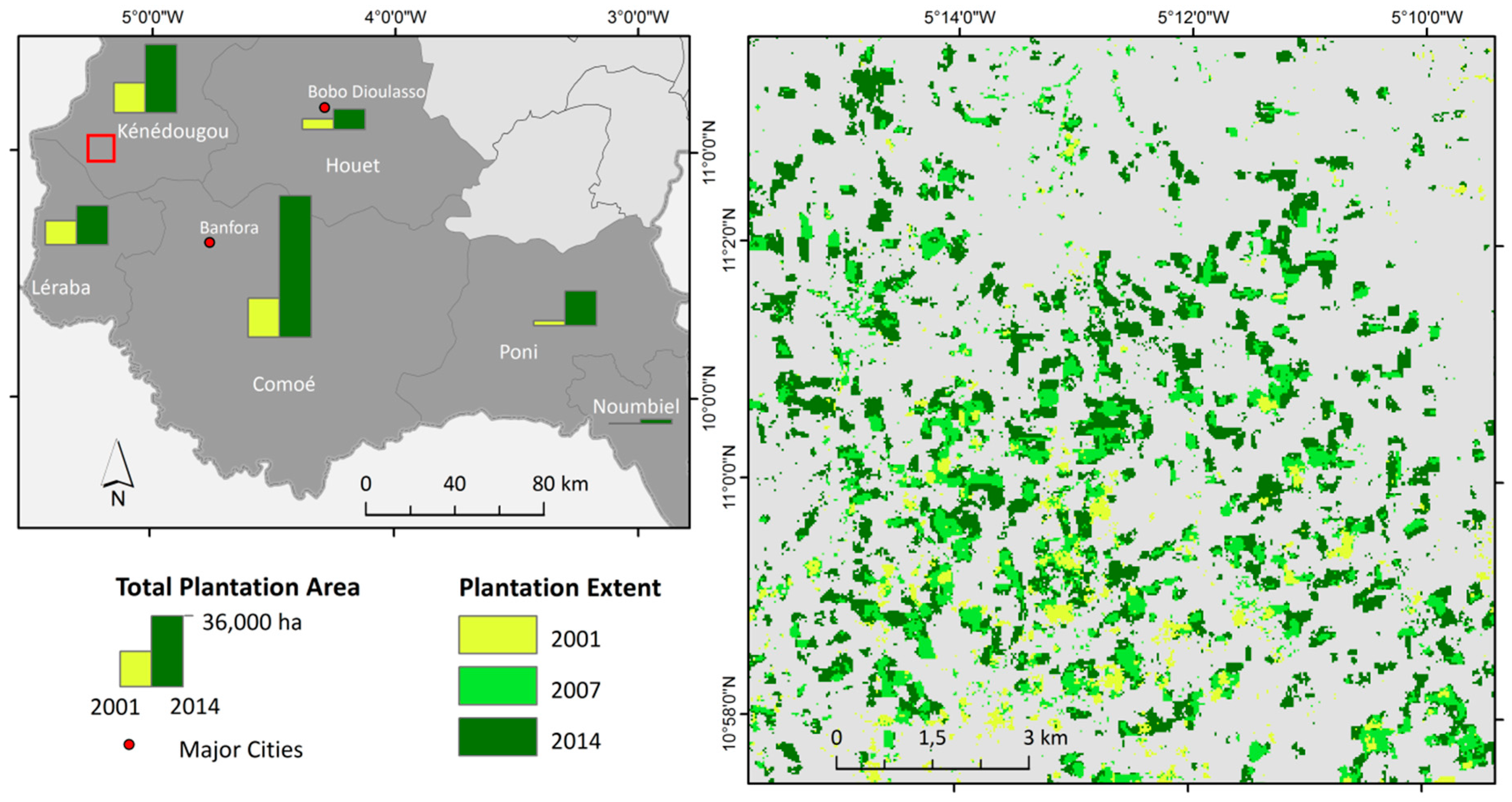
Between 2001 and 2014, a significant increase in plantation area of 179% from approximately 56,000 ha to 157,000 ha can be observed (compare
Table 3). The six southwestern provinces of Comoé, Kénédougou, Léraba, Poni, Houet, and Noumbiel (
Figure 5 left) make up 99% of Burkina Faso’s plantation area. The Comoé province alone contains about 71,000 ha of plantation in 2014, which corresponds to 46% of the total plantation area of Burkina Faso.
Figure 5 right reflects this development in detail, exemplarily for a focus site in the Kénédougou province, one of the major plantation regions of Burkina Faso. While the plantations in 2001 (light green) are rather small, scattered, and have undefined outlines, they increased considerably in size and numbers towards 2014 (dark green). Also the shapes of the plantations are much more distinct in 2014.
4.1.2. Development of Irrigation Area
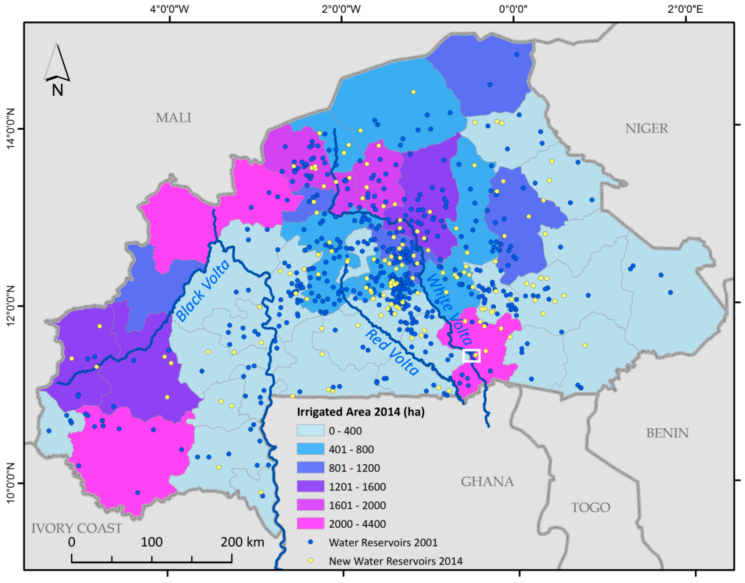
Efficient irrigated agriculture could be a key to improving food security in Burkina Faso and mitigating the negative effects of the varying timing and length of the rainy season for cultivation [
57]. The country has an estimated potential of about 233,500 ha irrigable land but as highlighted above only a small fraction of this area is currently under irrigation (34,500 ha in 2014) [
57,
58,
59]. The main areas of irrigation lie in the central, northern, and westernmost provinces of Burkina Faso (
Figure 6). Especially in the central and northern regions of Burkina Faso, the irrigation areas are mainly located around natural lakes or small water reservoirs established through the damming of rivers. Although, the smaller reservoirs are often used for household water supply and livestock than for irrigation, the distribution of reservoirs derived from the classification results partially reflects the provinces with higher irrigation area.
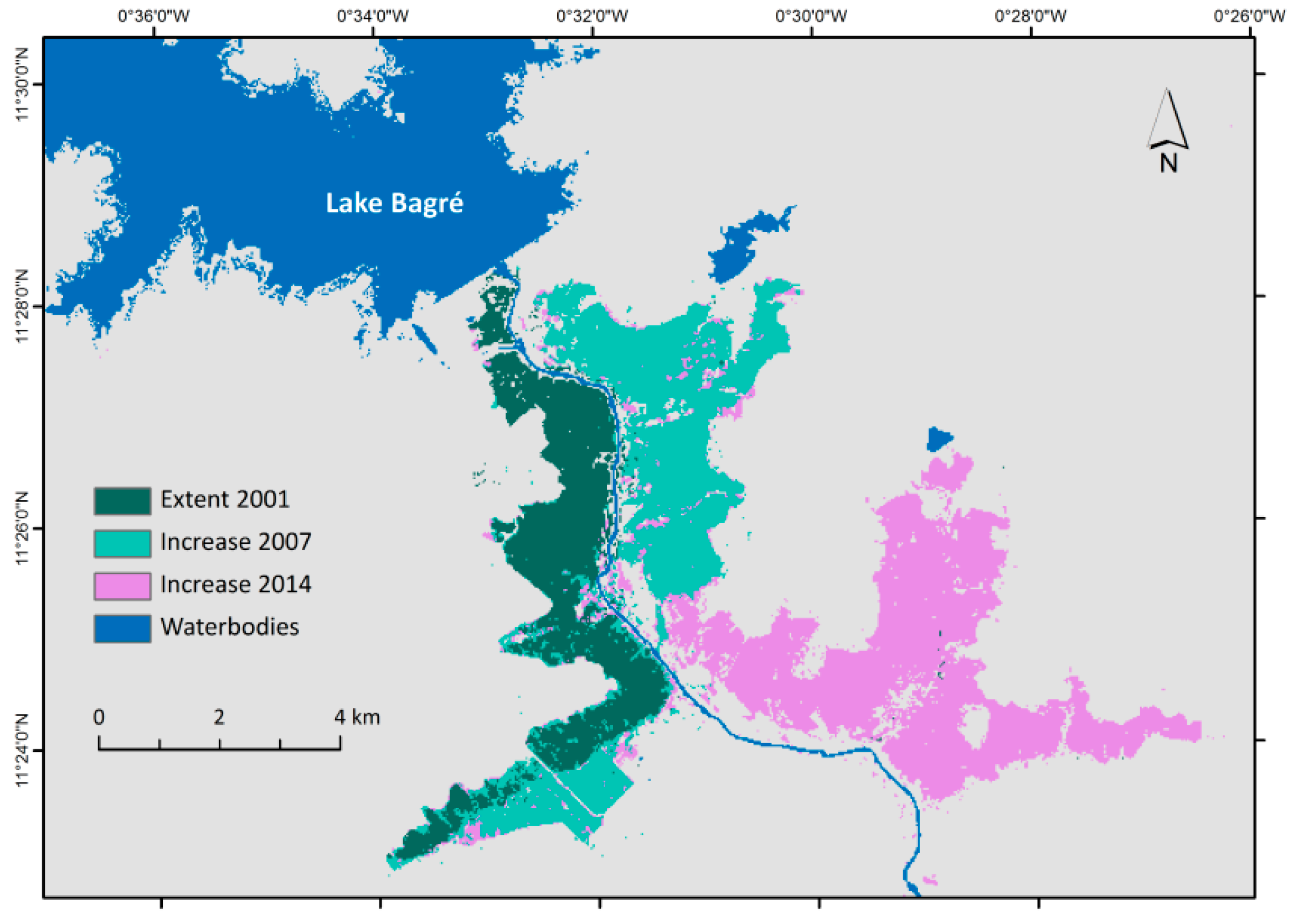
However, the highest values of irrigation area per province can be attributed to respective single major irrigation systems (confirmed by visual inspection). These areas receive their water supply directly from the major rivers of Burkina Faso and their tributary streams and not from reservoirs. One exception is the irrigation area at the Lake Bagré (
Figure 7 and white rectangle in
Figure 6), which developed with the construction of a hydropower dam retaining the water of the White Volta river in 1994. In 2001, the area under irrigation at the Lake Bagré covered approximately 9.26 km². In 2007 and 2014, it increased to 21.67 km² and to 37.28 km² respectively which equals an expansion of about 300% over the 14 years. Today, Lake Bagré is one of the biggest connected irrigation systems in Burkina Faso.
4.2. Feature Importance
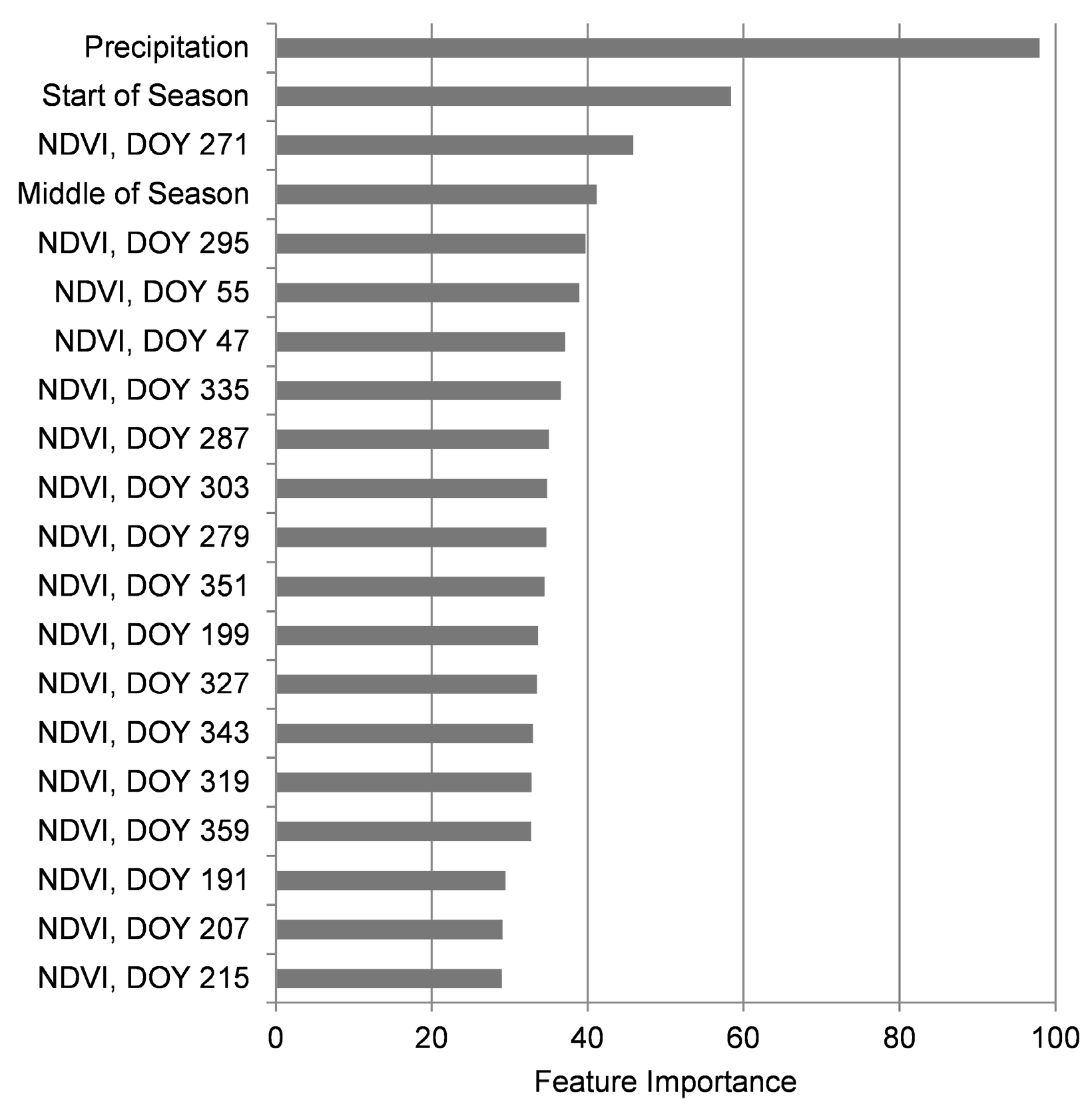
The respective importance of input features for the discrimination of different classes in the study area is shown in
Figure 8. Precipitation is the most important feature representing the North-South moisture gradient of Burkina Faso and the general occurrence of classes along this gradient. In general, wetlands and forests are more frequent in Burkina Faso’s southern regions. The Start of Season (SOS) shows early dates for the irrigated agricultural areas which are more independent of the onset of rainfalls, while rainfed agricultural areas generally show later SOS than the natural vegetation classes. This can be explained by the reaction of natural vegetation to the first rainfalls while rainfed agricultural areas are commonly sown later. The NDVI of DOY 271 (end of September) represents the peak of rainy season, similar to the Middle of Season (MOS) feature. For dense vegetation classes such as forests and plantation, the NDVI of DOY 271 is generally higher and the MOS tends to be later.
4.3. Relationship between Agricultural Expansion and Population Growth
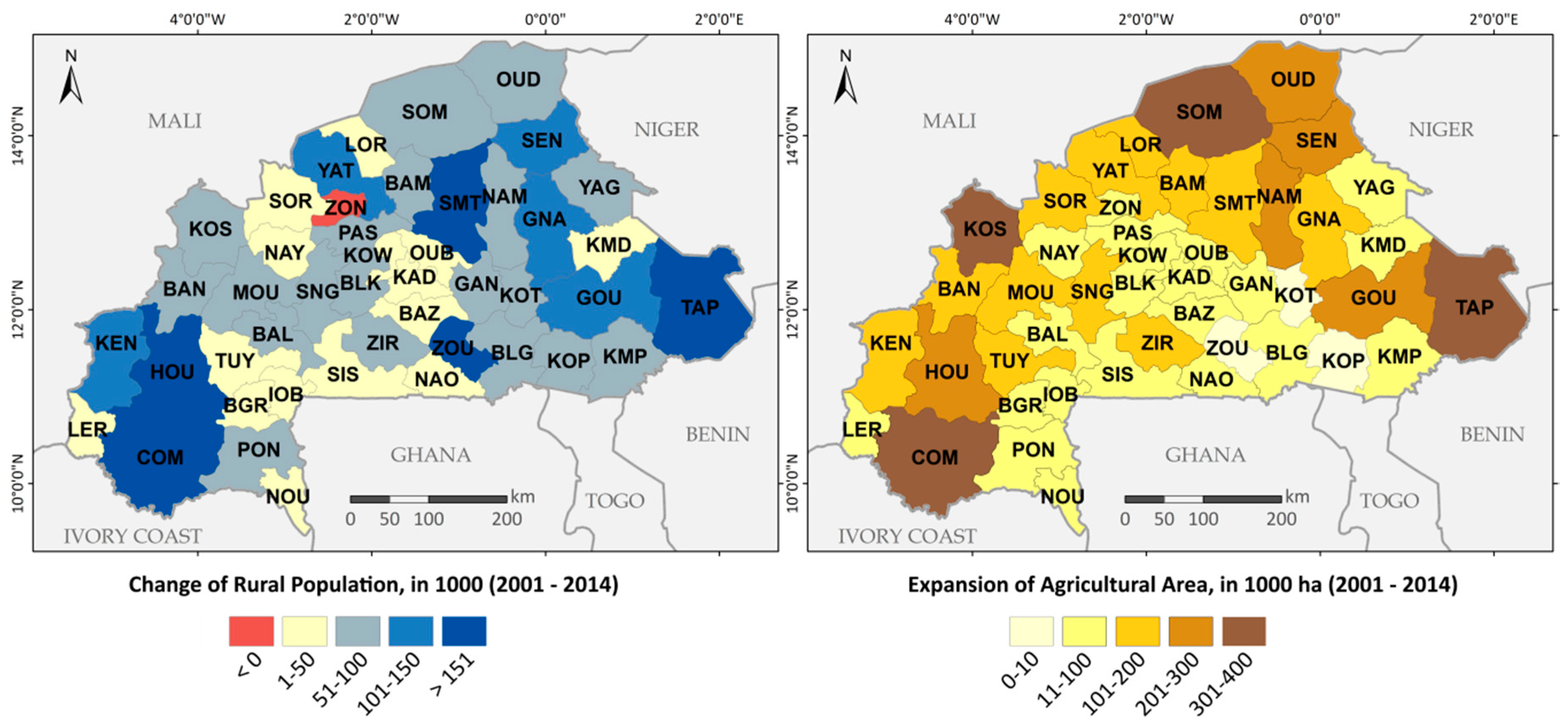
The total population of Burkina Faso grew rapidly during the period of investigation from approx. 12 million in 2001 to more than 17 million people in 2014 [
1]. As outlined in
Section 2, also the rural population increased in almost all provinces during that time. Especially the more remote provinces like Tapoa (TAP), Comoé (COM) or Houet (HOU) increased in rural population by up to 244,000 people (
Figure 9 left) [
35]. The central provinces with an already high population density in 2001 as well as the central southern provinces only increased moderately in population numbers. The only province with a negative rural population development is the province of Zondoma (ZON) decreasing by about 58,000 rural inhabitants.
Similar patterns as for the rural population growth can be observed for the expansion of agricultural area in the provinces between 2001 and 2014 (
Figure 9 right). Agriculture spread into all remote and so far rather uncultivated regions of Burkina Faso. The above mentioned provinces Tapoa (TAP) and Comoé (COM) are among the provinces with the biggest agricultural expansion with an increase of about 323,000 ha and 315,000 ha, respectively. However, the highest numbers of expansion are observed for the two Northern provinces Kossi (KOS) with a plus of 392,000 ha and Soum (SOM) with an increase of 386,000 ha between 2001 and 2014. Similar to the changes in population growth, the central provinces show only moderate levels of agricultural expansion between 600 ha for the Koulpélogo province (KOP) and 60,000 ha for the Bazèga province (BAZ).
In a quantitative comparison of agricultural area and rural population in the provinces, a direct relationship becomes evident. For 2001, the numbers of rural inhabitants correlate with the extent of agricultural areas (r = 0.84) with highest numbers primarily for the larger central provinces like Sanmatenga (SMT), Boulgou (BLG), and Yatenga (YAT) (
Figure 10a). For 2014, the numbers for the two variables generally increase in the provinces but the relationship between them stays the same (r = 0.84) (
Figure 10b). While the leading provinces of 2001 are still among the highest in 2014, the above mentioned remote provinces of Comoé (COM), Soum (SOM), and especially a group of provinces from the region Est, Tapoa (TAP), Gourma (GOU), and Gnagna (GNA), joined the provinces with highest population numbers and biggest agricultural area. Though there are various reasons and pathways for different developments of the two variables, it is obvious that agricultural expansion and rural population growth go in line for multiple provinces (
Figure 10c). Besides some single provinces, the more remote regions of Est, Sahel and Boucle de Mouhoun exhibit the highest changes in both variables. The central and generally smaller provinces of the regions Centre-Est, Centre-Sud, and Plateau Central only increased in rural population numbers without considerable agricultural expansion.
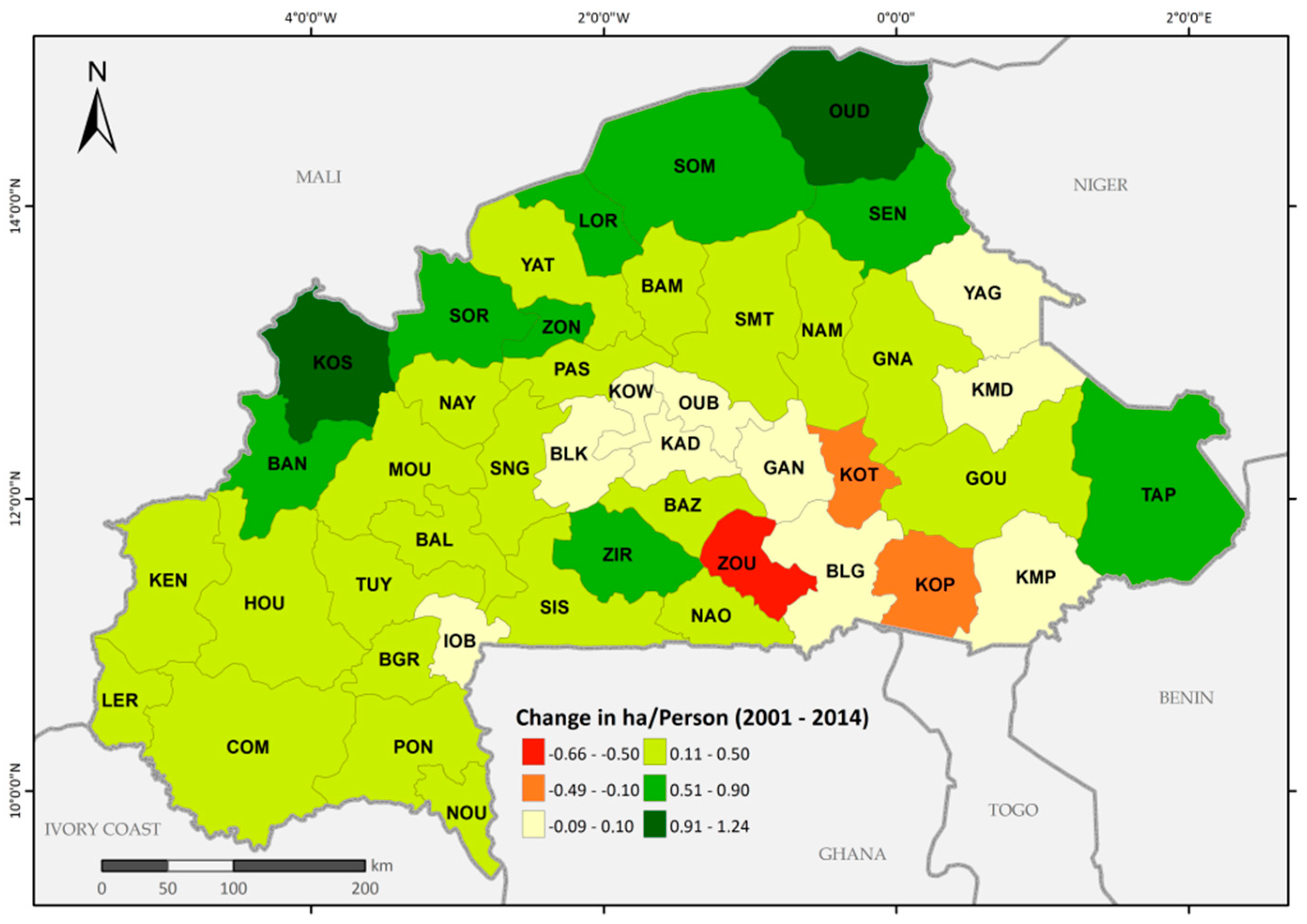
The average agricultural area per rural inhabitant rose from 0.63 ha to 0.88 ha (
Figure 11). Especially in the more remote provinces like Oudalan (OUD), Soum (SOM) or Kossi (KOS) the agricultural area grew considerably while there was only a moderate population growth resulting in increases of up to 1.24 ha/person. While most provinces registered a plus in agricultural area per person, some provinces in the central and southwest of Burkina Faso almost did not change or decreased. Especially the provinces Zoundwéogo (ZOU), Kouritenga (KOT), and Koulpélogo (KOP) lost up to 0.66 ha per person. These are also the provinces with the smallest agricultural expansion while still increasing their rural population numbers by up to 240,000 people (ZOU) over the considered 14 years.
4.4. Implications for Natural Reserves
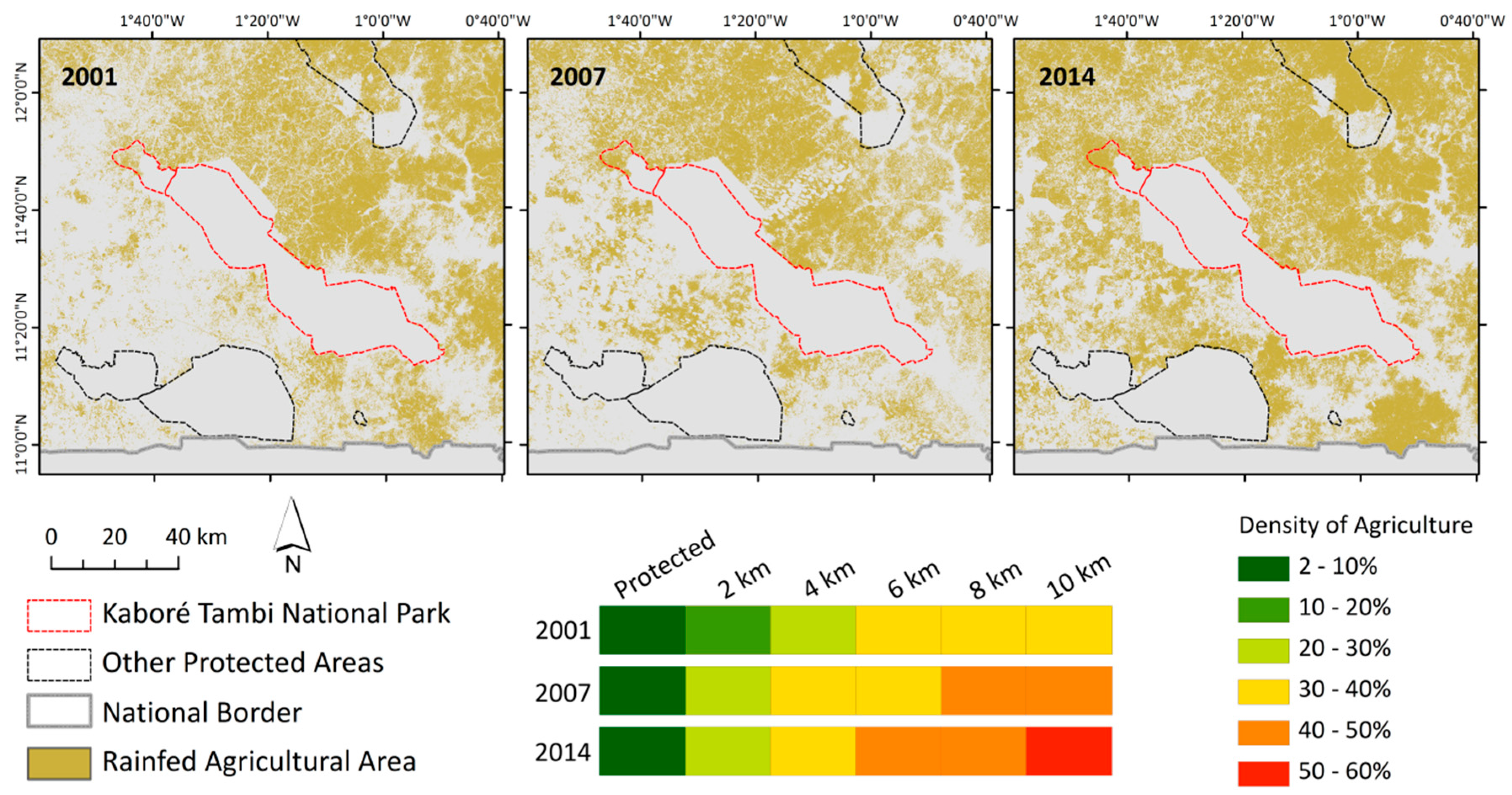
In this section, an in-depth study of two protected areas (compare
Figure 4) was conducted showing the development of agricultural area in their vicinity. The first one is the Kaboré Tambi National Park, which was founded in 1976 and directly adjacent in the Northwest, the classified forest Nazinon which lie about 60 km south of Ouagadougou (
Figure 1 and
Figure 12). In 2001, the agricultural area inside the boundaries of the two protected areas was very low (3%) and was almost exclusively found in the Nazinon forest. Also the direct surroundings of the Kaboré Tambi are only marginally cultivated because of an apparent buffer zone around parts of the park borders.
Between 2001 and 2007, the agriculture in these protected areas did not change but it increased in all distance zones with a maximum of 43% within the 8–10 km zone. In 2014, the cultivated area in this zone increased by another 8% and values of dense agriculture are drawing closer to the park, but the protected area remains unaffected. This indicates a functioning protection of the park despite the concentration of agricultural area in its vicinity. However, this concentration also increases the isolation of the park and hinders animal movement to other habitat areas with a decreasing number of natural patches (stepstones) in between.
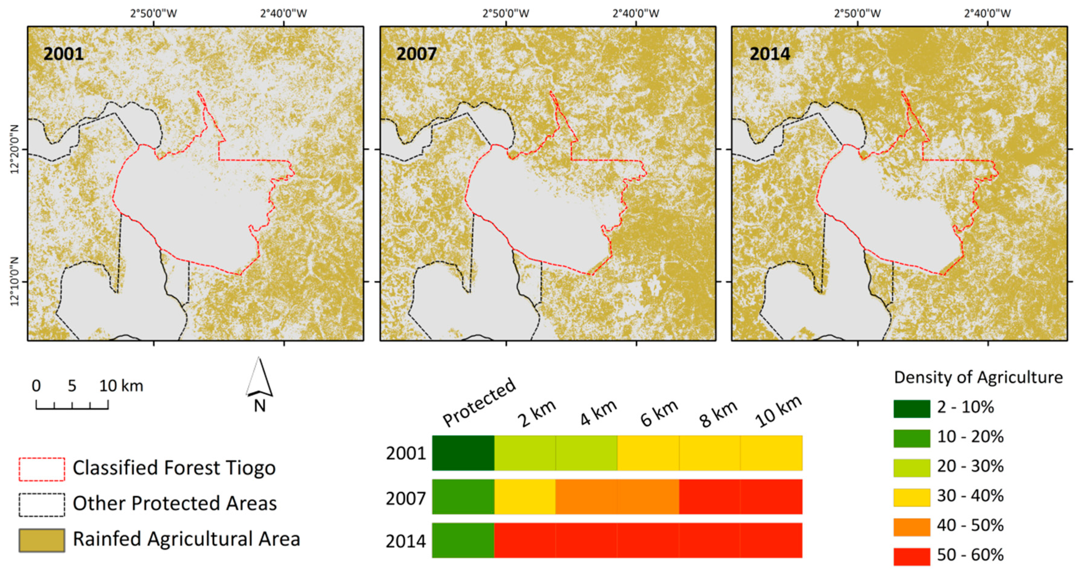
The second example, the classified forest of Tiogo is located about 130 km west of Ouagadougou and is a formally protected area adjacent to other areas with the same status (
Figure 1 and
Figure 13). However, Tiogo does not underlie an exclusive park management as the Kaboré Tambi National Park [
60].
In 2001, some croplands were detected in the northeastern part of Tiogo but so far they only cover 3% of the total area. The agricultural area in the surroundings of the park is moderately dense and reaches up to 36% in the 4–6 km distance zone. In 2007, the fields in the Northeast of Tiogo advance towards the center of the protected area and increased significantly to 13% of the total forest area. Also the surrounding agriculture increases in all distance zones with a maximum of 51% in the 8–10 km zone. Finally in 2014, the agriculture in the northeastern part of Tiogo intensifies (18% of total area) and dense agricultural area covering more than 50% starts right at the border of the Tiogo classified forest increasing the pressure on the remaining protected area.
6. Conclusions
In this study, the ESTARFM framework was applied for the generation of a high temporal (8-day) and high spatial (30 m) resolution time series for the country of Burkina Faso, with an area of approx. 274.000 km². The fused time series were further used as a basis for the delineation of agricultural area in a spatial resolution of 30 m for entire Burkina Faso and for three years—2001, 2007, and 2014. To our knowledge, there is no other national product available at this spatial, temporal, and thematic resolution with an equal quality. Prior studies outline the challenges in the derivation of agricultural area from remote sensing data in West Africa [
17,
18,
19,
48]. The predominant small-scale rainfed subsistence farming and the low productivity of the fields complicates the separation of agricultural area from other land use and cover types. Despite these difficulties, the overall accuracies of 92% (2001), 91% (2007), and 91% (2014) of the presented results indicate the well-functioning of the method applied here. The possibility to use the whole phenological cycle of NDVI in a sufficiently high spatial resolution as input for the classification is a key factor for the delineation of agricultural area in the region.
Furthermore, the presented results give insight into the development of plantations, the establishment of irrigation systems, and the protection of natural reserves in Burkina Faso. This information can be important for decision makers in order to understand and quantify if recently initiated measures for the development of agricultural systems have the intended effects. For this purpose, the map** and monitoring with the developed method could also be continued for subsequent years.
The results and analyses presented in this study highlight major challenges in terms of food production systems and food security Burkina Faso is facing and will face in the future. The massive expansion of agricultural area (from 61,100 km² in 2001 to 116,900 km² in 2014) is pushing towards the limit of available arable land and potentially more and more unsuitable regions will be used for cultivation. With a rapidly increasing population, this expansion is likely to continue if the productivity will not be improved significantly in the near future. These trends are also threatening the remnant natural reserves of Burkina Faso with illegal logging and cultivation on protected land. In future, the introduction of new satellite systems such as Sentinel-2 and -3 should improve the input data availability and facilitate subsequent applications of the developed approach for the delineation of agricultural area.
This study also highlights the great potential of the dense time series generated with the ESTARFM framework beyond its use for agricultural studies in Burkina Faso [
24]. Further applications, where a combination of high temporal and spatial resolution would be essential, could be the analysis of land degradation or changes in the land surface phenology in Burkina Faso [
24].


