Surface Motion and Structural Instability Monitoring of Ming Dynasty City Walls by Two-Step Tomo-PSInSAR Approach in Nan**g City, China

 ,
,  ,
,
Abstract
:
1. Introduction
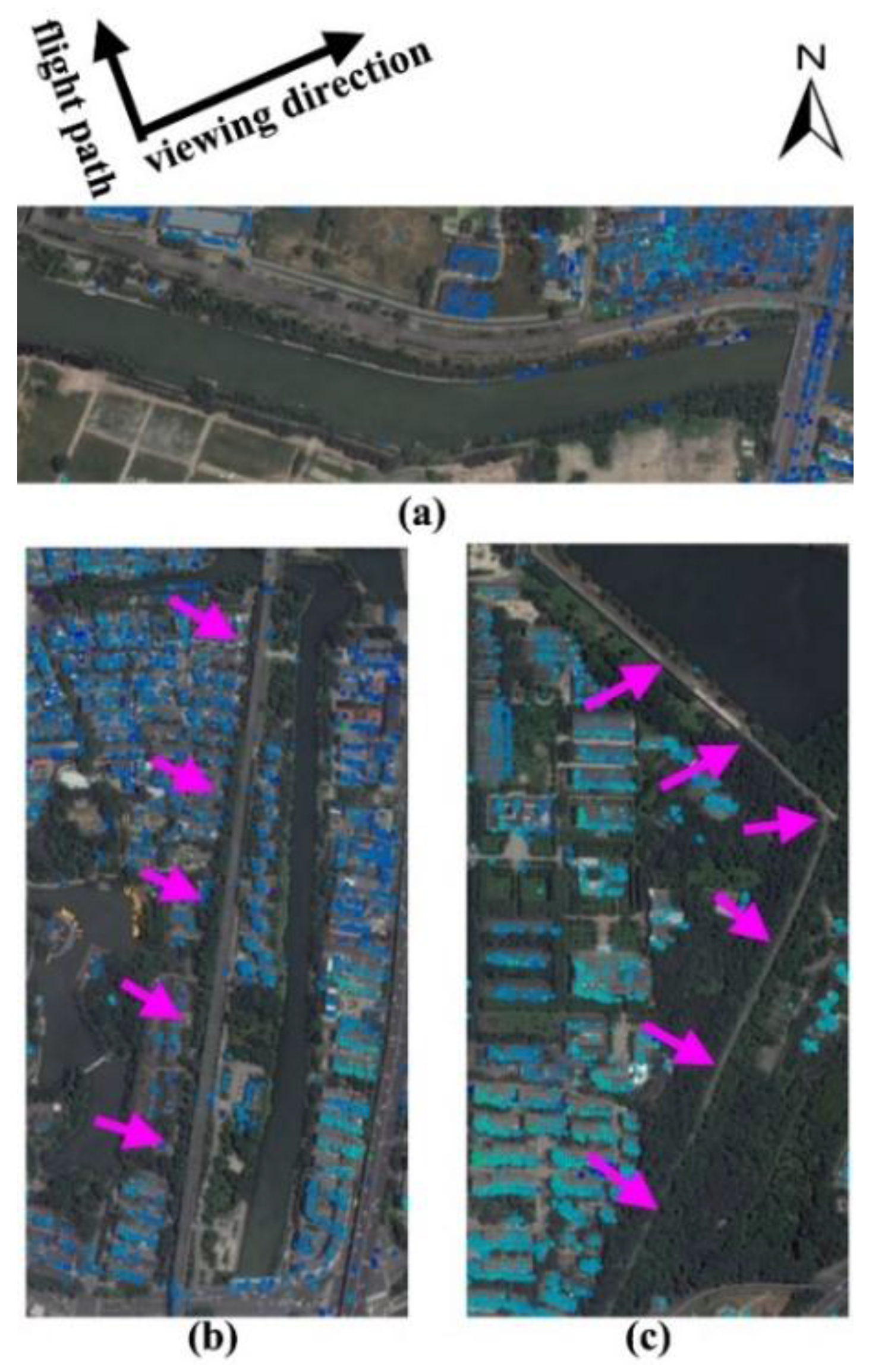
2. Study Site and Data Used
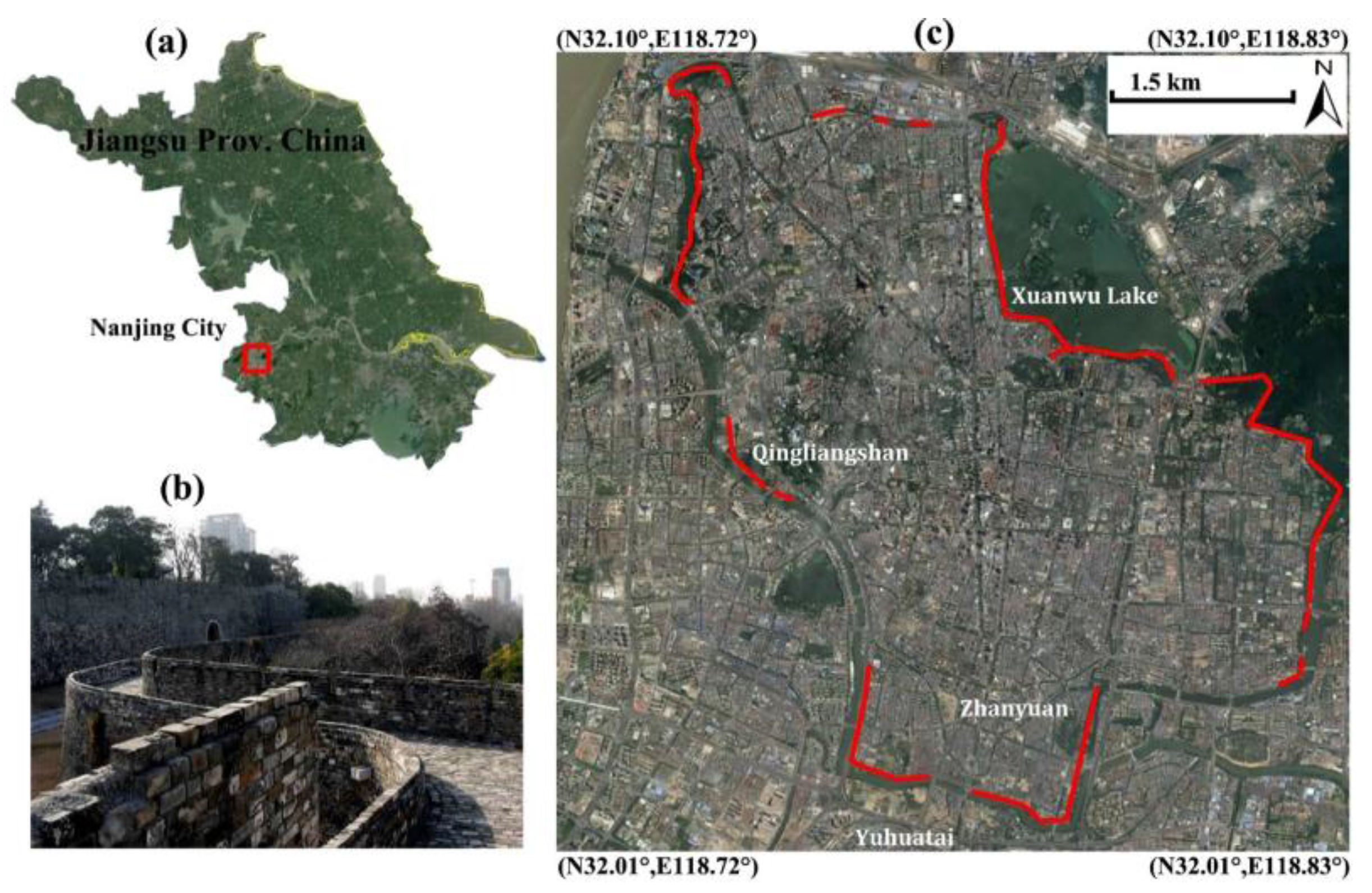
2.1. Study Site
3. Principles and Methodology
3.1. Rational Basis
3.2. Two-Step Tomo-PSInSAR Approach
3.3. Technology Improvements
4. Results and Interpretation
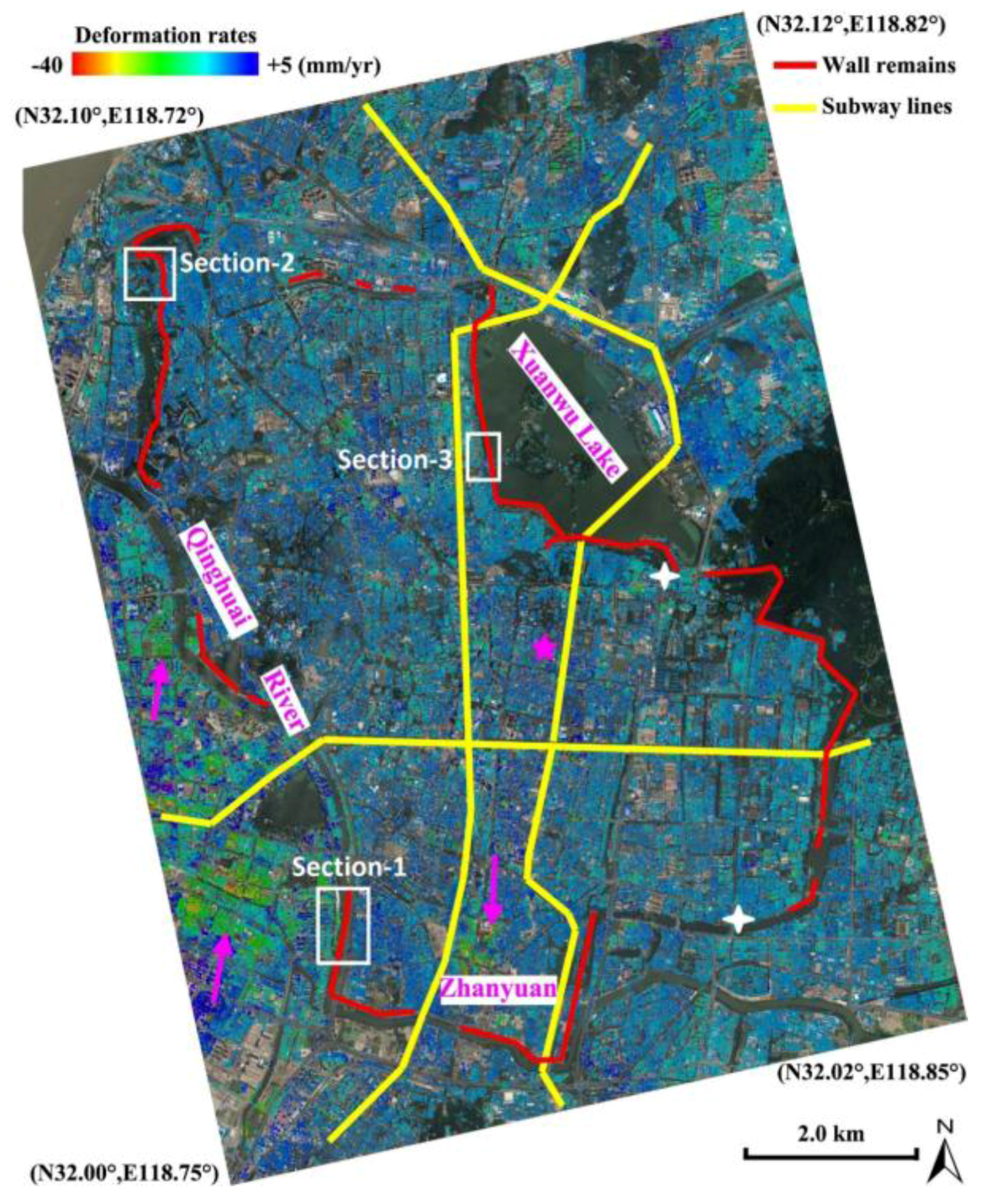
4.1. Regional-Scale Monitoring
4.2. Monument-Scale Monitoring
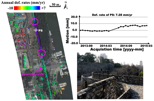
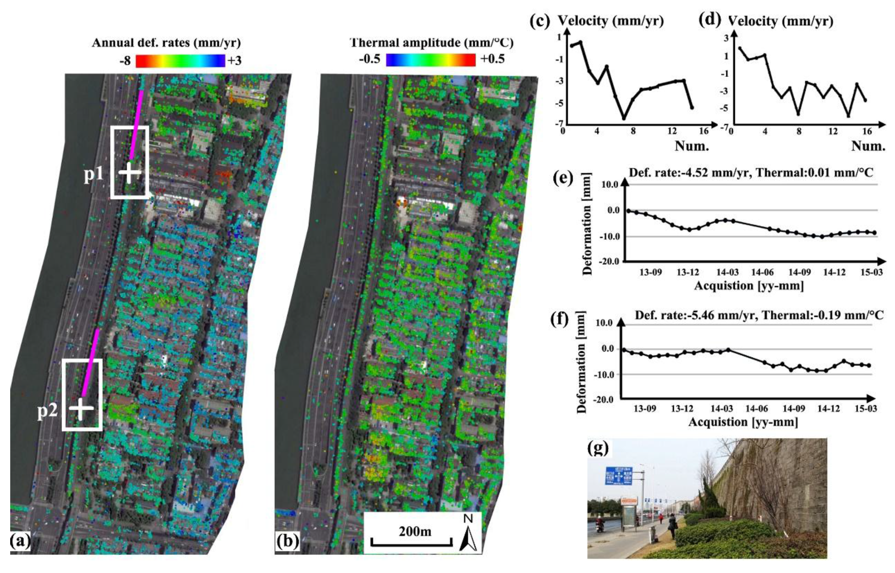
4.2.1. Section-1
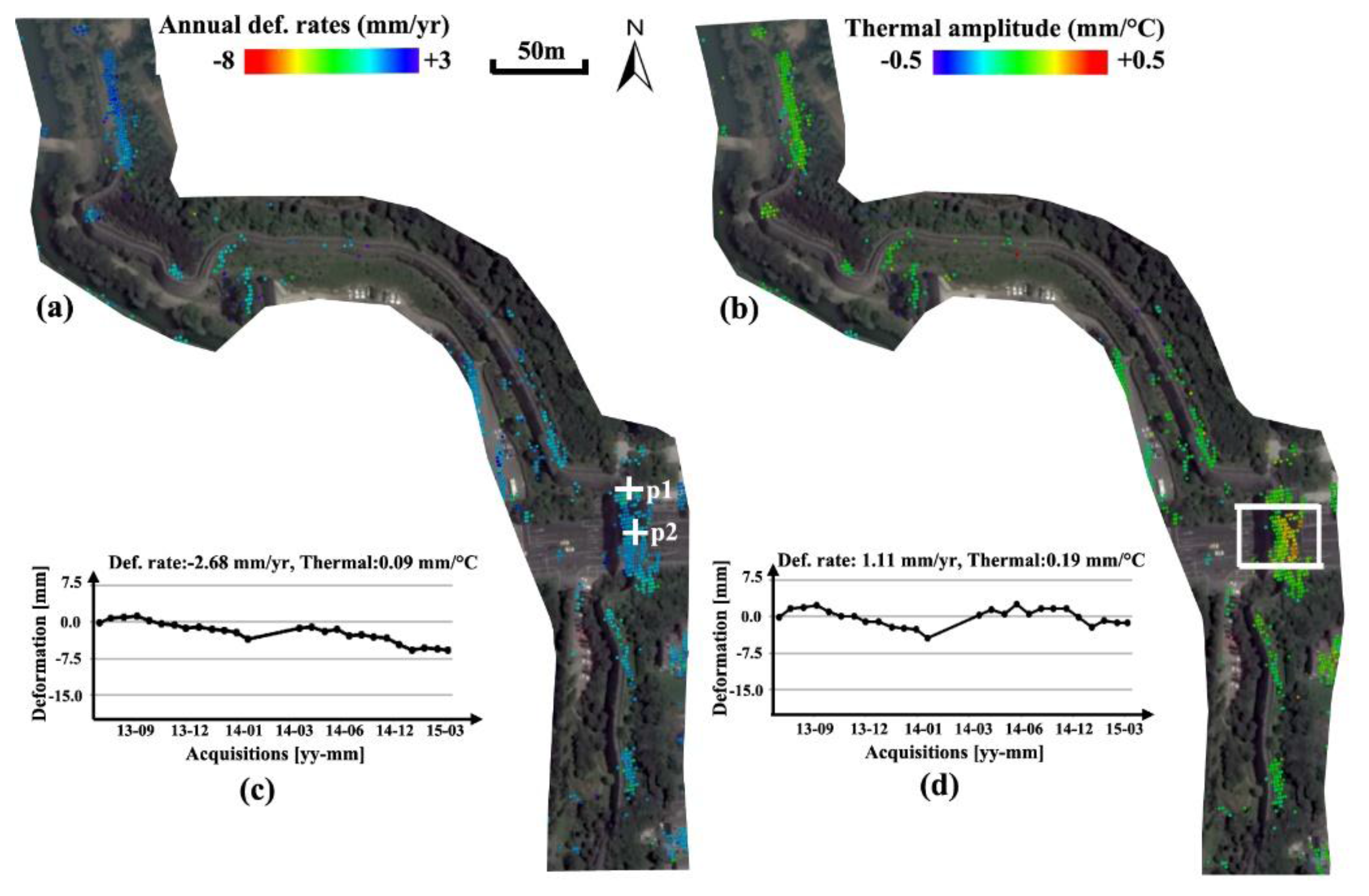
4.2.2. Section-2
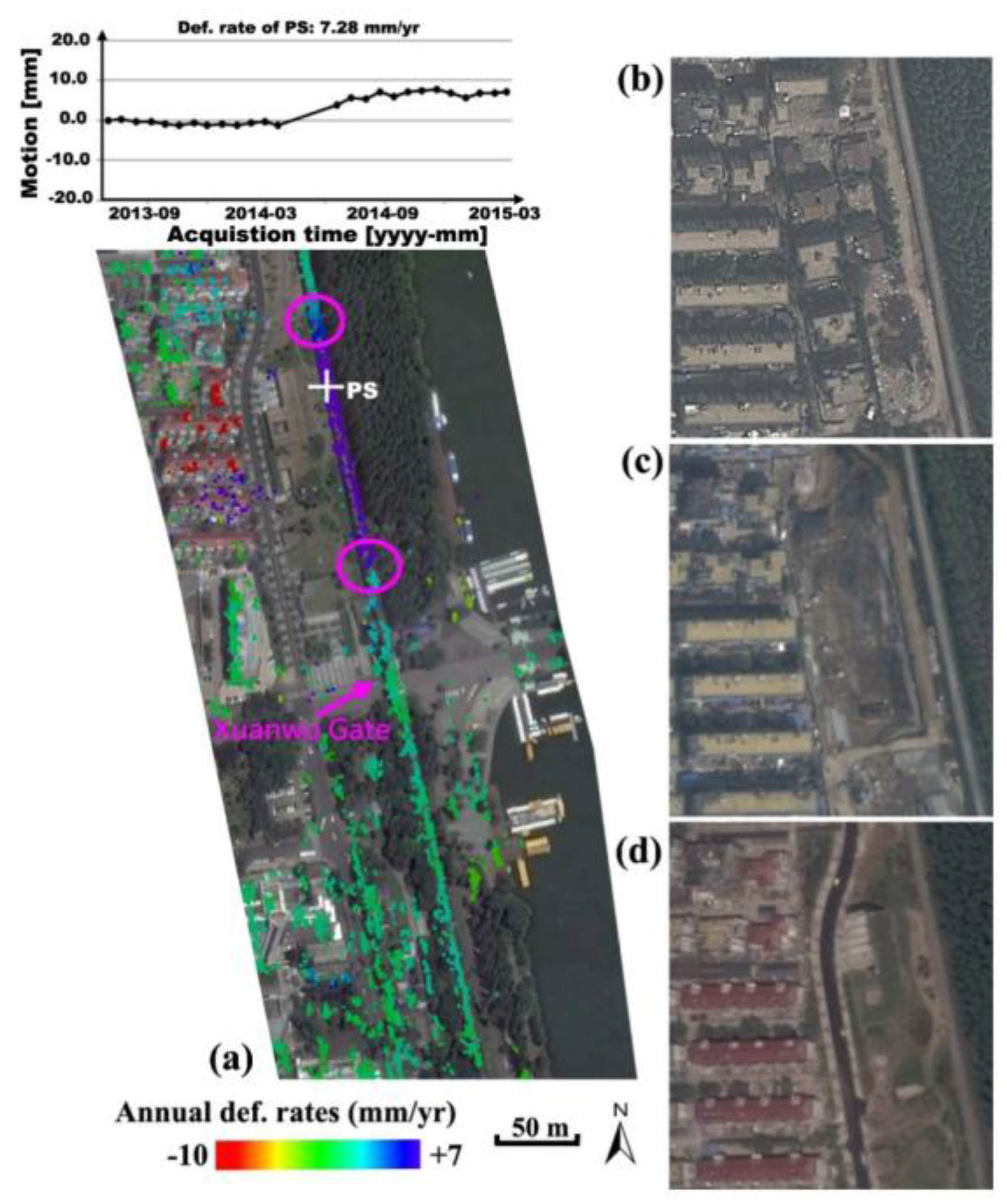
4.2.3. Section-3
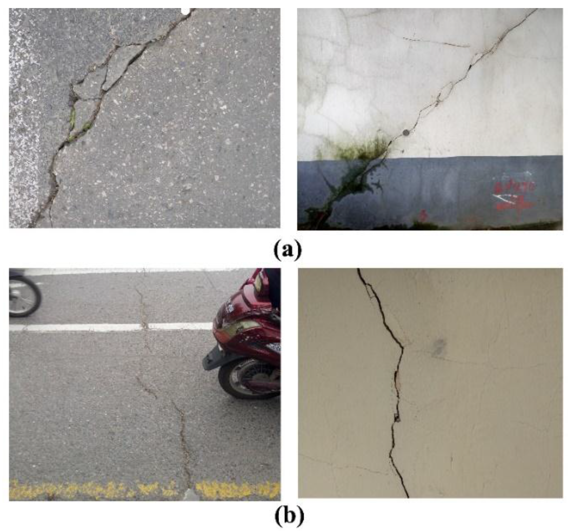
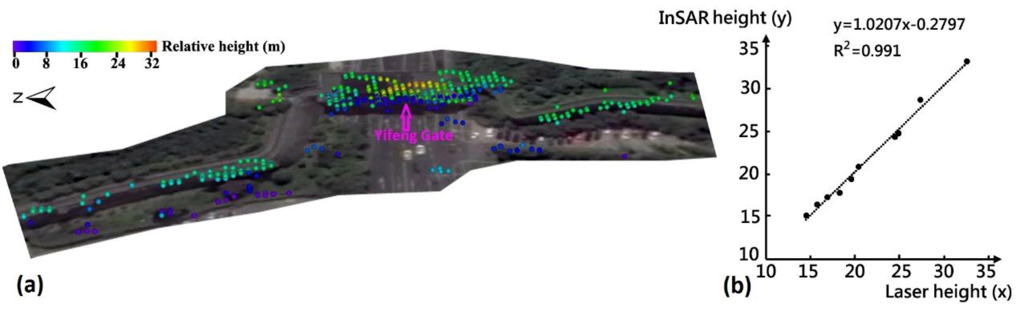
4.3. Validation
5. Discussion
6. Conclusions
Acknowledgments
Author Contributions
Conflicts of Interest
References
- Chen, F.; Lin, H.; Hu, X. Slope superficial displacement monitoring by small baseline SAR interferometry using data from L-band ALOS PALSAR and X-band TerraSAR: A case study of Hong Kong. Remote Sens. 2014, 6, 1564–1586. [Google Scholar] [CrossRef]
- Ferretti, A.; Prati, C.; Rocca, F. Permanent scatterers in SAR interferometry. IEEE Trans. Geosci. Remote Sens. 2001, 39, 8–20. [Google Scholar] [CrossRef]
- Ferretti, A.; Prati, C.; Rocca, F. Nonlinear subsidence rate estimation using permanent scatterers in differential SAR interferometry. IEEE Trans. Geosci. Remote Sens. 2000, 38, 2202–2212. [Google Scholar] [CrossRef]
- Kampes, B.M. Radar Interferometry: Persistent Scatterer Technique; Springer: Dordrecht, The Netherlands, 2006. [Google Scholar]
- Hooper, A.; Segall, P.; Zebker, H. Persistent scatterer interferometric synthetic aperture radar for crustal deformation analysis, with application to Volcán Alcedo, Galápagos. J. Geophys. Res. 2007, 112, B07407. [Google Scholar] [CrossRef]
- Berardino, P.; Fornaro, G.; Lanari, R.; Sansosti, E. A new algorithm for surface deformation monitoring based on small baseline differential SAR interferograms. IEEE Trans. Geosci. Remote Sens. 2002, 40, 2375–2383. [Google Scholar] [CrossRef]
- Ferretti, A.; Fumagalli, A.; Novali, F.; Prati, C.; Rocca, F. A New algorithm for processing interferometric data-stacks: SqueeSAR. IEEE Trans. Geosci. Remote Sens. 2011, 49, 3460–3470. [Google Scholar] [CrossRef]
- Tapete, D.; Fanti, R.; Cecchi, R. Satellite radar interferometry for monitoring and early-stage warning of structural instability in archaeological sites. J. Geophys. Eng. 2012, 9, 10–25. [Google Scholar] [CrossRef]
- Cigna, F.; Lasaponara, R.; Masini, N.; Milillo, P.; Tapete, D. Persistent Scatterer Interferometry Processing of COSMO-SkyMed StripMap HIMAGE Time Series to Depict Deformation of the Historic Centre of Rome, Italy. Remote Sens. 2014, 6, 12593–12618. [Google Scholar] [CrossRef]
- Chen, F.; Jiang, A.; Ishwaran, N. Angkor site monitoring and evaluation by radar remote sensing. Proceedings of Land Surface Remote Sensing II, Asia-Pacific Remote Sensing Symposium 2014, Bei**g, China, 13–17 October 2014. [Google Scholar]
- Chaussard, E.; Wdowinski, S.; Cabral-Cano, E.; Amelung, F. Land subsidence in central Mexico detected by ALOS InSAR time-series. Remote Sens. Environ. 2014, 140, 94–106. [Google Scholar] [CrossRef]
- Tang, P.; Chen, F.; Zhu, X.; Zhou, W. Monitoring cultural heritage sites with advanced multi-temporal InSAR technique: The case study of the Summer Palace. Remote Sens. 2016, 8, 432. [Google Scholar] [CrossRef]
- De Maio, A.; Fornaro, G.; Pauciullo, A. Detection of single scatterers in multidimensional SAR imaging. IEEE Trans. Geosci. Remote Sens. 2009, 47, 2284–2297. [Google Scholar] [CrossRef]
- Ma, P.; Lin, H.; Lan, H.; Chen, F. Multi-dimensional SAR tomography for monitoring the deformation of newly built concrete buildings. ISPRS J. Photogramm. Remote Sens. 2015, 106, 118–128. [Google Scholar] [CrossRef]
- Fornaro, G.; Serafino, F.; Reale, D. 4-D SAR imaging: the case study of Rome. IEEE Geosci. Remote Sens. Lett. 2010, 7, 236–240. [Google Scholar] [CrossRef]
- Zhu, X.X.; Montazeri, S.; Gisinger, C.; Hanssen, R.F.; Bamler, R. Geodetic SAR Tomography. IEEE Trans. Geosci. Remote Sens. 2016, 54, 18–35. [Google Scholar] [CrossRef]
- Wei, L.; Balz, T.; Zhang, L.; Liao, M. A novel fast approach for SAR tomography: Two-step iterative shrinkage/thresholding. IEEE Geosci. Remote Sens. Lett. 2015, 12, 1377–1381. [Google Scholar]
- Schmitt, M.; Shahzad, M.; Zhu, X.X. Reconstruction of individual trees from multi-aspect TomoSAR data. Remote Sens. Environ. 2015, 165, 175–185. [Google Scholar] [CrossRef]
- Lombardini, F. Differential tomography: A new framework for SAR interferometry. IEEE Trans. Geosci. Remote Sens. 2005, 43, 37–44. [Google Scholar] [CrossRef]
- Crosetto, M.; Monserrat, O.; Cuevas-González, M.; Devanthéry, N.; Luzi, G.; Crippa, B. Measuring thermal expansion using X-band persistent scatter interferometry. ISPRS J. Photogramm. Remote Sens. 2015, 100, 84–91. [Google Scholar] [CrossRef]
- Ma, P.; Lin, H. Robust detection of single and double persistent scatterers in urban built environments. IEEE Trans. Geosci. Remote Sens. 2016, 54, 2124–2139. [Google Scholar] [CrossRef]
- Lombardini, F.; Viviani, F. New development of 4D+ differential SAR tomography to probe complex dynamic scenes. In Proceedings of the IGARSS 2014, Quebec City, QC, Canada, 13–18 July 2014; pp. 3362–3365. [Google Scholar]
- Siddique, M.A.; Wegmüller, U.; Hajnsek, I.; Frey, O. Single-look SAR tomography as an add-on to PSI for improved deformation analysis in urban areas. IEEE Trans. Geosci. Remote Sens. 2016, 54, 6119–6137. [Google Scholar] [CrossRef]
- Huber, P.J. Robust estimation of a location parameter. Ann. Math. Stat. 1964, 35, 73–101. [Google Scholar] [CrossRef]
- Fornaro, G.; Lombardini, F.; Pauciullo, A.; Reale, D.; Viviani, F. Tomographic Processing of Interferometric SAR Data: Developments, applications, and future research perspectives. IEEE Signal Process. Mag. 2014, 31, 41–50. [Google Scholar] [CrossRef]
- Xu, S.; Yan, C.; Sun, Y. Environmental geological problems of urban underground engineering. J. Eng. Geol. 2003, 11, 127–132. [Google Scholar]
- Shi, S.Q.; Pan, F.Y.; Miao, B.Z. Old channel and its influence on municipal construction in Nan**g city. Jiangsu Geol. 1990, 1, 31–34. [Google Scholar]
- Tapete, D.; Morelli, S.; Fanti, R.; Casagli, N. Localising deformation along the elevation of linear structures: An experiment with spaceborne InSAR and RTK GPS on the Roman Aqueducts in Rome, Italy. Appl. Geogr. 2015, 58, 65–83. [Google Scholar] [CrossRef]
- Chang, L.; Hanssen, R.F. Detection of cavity migration and sinkhole risk using radar interferometric time series. Remote Sens. Environ. 2014, 147, 56–64. [Google Scholar] [CrossRef]


| No. | Acquisitions | Bperp (m) | Temp. (°C) |
|---|---|---|---|
| 1 | 2013-05-31 | 113.83 | 24.0 |
| 2 | 2013-06-22 | 303.16 | 31.0 |
| 3 | 2013-07-14 | 254.63 | 32.0 |
| 4 | 2013-08-05 | 68.81 | 36.0 |
| 5 | 2013-08-27 | −102.96 | 32.0 |
| 6 | 2013-09-18 | 23.02 | 29.0 |
| 7 | 2013-10-10 | 35.22 | 28.0 |
| 8 | 2013-11-01 | −33.09 | 20.0 |
| 9 | 2013-11-23 | −125.49 | 18.0 |
| 10 | 2013-12-15 | 0.66 | 12.0 |
| 11 | 2014-01-06 | −87.22 | 13.0 |
| 12 | 2014-01-28 * | 0 | 13.0 |
| 13 | 2014-02-19 | 140.29 | 5.0 |
| 14 | 2014-05-18 | −49.15 | 25.0 |
| 15 | 2014-06-09 | 375.85 | 31.0 |
| 16 | 2014-07-01 | −10.11 | 25.0 |
| 17 | 2014-07-23 | −219.30 | 35.0 |
| 18 | 2014-08-14 | −28.35 | 24.0 |
| 19 | 2014-09-05 | 127.44 | 29.0 |
| 20 | 2014-09-27 | 19.78 | 28.0 |
| 21 | 2014-10-19 | 149.93 | 27.0 |
| 22 | 2014-11-10 | 91.43 | 17.0 |
| 23 | 2014-12-02 | −154.36 | 6.0 |
| 24 | 2014-12-24 | 195.37 | 12.0 |
| 25 | 2015-01-15 | −151.47 | 10.0 |
| 26 | 2015-02-06 | 76.89 | 9.0 |
| Velocity Rates (mm/Year) | |||||||||||||||
|---|---|---|---|---|---|---|---|---|---|---|---|---|---|---|---|
| 0.3 | 0.6 | −2.0 | −3.1 | −1.6 | −4.3 | −6.3 | −4.6 | −3.7 | −3.6 | −3.4 | −1.7 | −0.6 | −3.2 | ||
| 1.8 | 0.5 | 0.7 | 1.0 | −2.6 | −3.8 | −2.7 | −5.7 | −2.1 | −2.4 | −3.8 | −2.5 | −3.6 | −5.9 | −2.3 | −4.1 |
© 2017 by the authors. Licensee MDPI, Basel, Switzerland. This article is an open access article distributed under the terms and conditions of the Creative Commons Attribution (CC BY) license (http://creativecommons.org/licenses/by/4.0/).
Share and Cite
Chen, F.; Wu, Y.; Zhang, Y.; Parcharidis, I.; Ma, P.; **ao, R.; Xu, J.; Zhou, W.; Tang, P.; Foumelis, M. Surface Motion and Structural Instability Monitoring of Ming Dynasty City Walls by Two-Step Tomo-PSInSAR Approach in Nan**g City, China. Remote Sens. 2017, 9, 371. https://doi.org/10.3390/rs9040371
Chen F, Wu Y, Zhang Y, Parcharidis I, Ma P, **ao R, Xu J, Zhou W, Tang P, Foumelis M. Surface Motion and Structural Instability Monitoring of Ming Dynasty City Walls by Two-Step Tomo-PSInSAR Approach in Nan**g City, China. Remote Sensing. 2017; 9(4):371. https://doi.org/10.3390/rs9040371
Chicago/Turabian StyleChen, Fulong, Yuhua Wu, Yimeng Zhang, Issaak Parcharidis, Peifeng Ma, Ruya **ao, Jia Xu, Wei Zhou, Panpan Tang, and Michael Foumelis. 2017. "Surface Motion and Structural Instability Monitoring of Ming Dynasty City Walls by Two-Step Tomo-PSInSAR Approach in Nan**g City, China" Remote Sensing 9, no. 4: 371. https://doi.org/10.3390/rs9040371