A New Urban Index for Expressing Inner-City Patterns Based on MODIS LST and EVI Regulated DMSP/OLS NTL

 , ,
, ,
Abstract
:
1. Introduction
2. Data Resources
2.1. Night Time Lights (NTL) Data
2.2. Auxiliary Data
3. Methods
3.1. Vegetation Adjusted NTL Urban Index
3.2. LST- and EVI-Regulated NTL City Index
3.3. Validation Methodology
- (1)
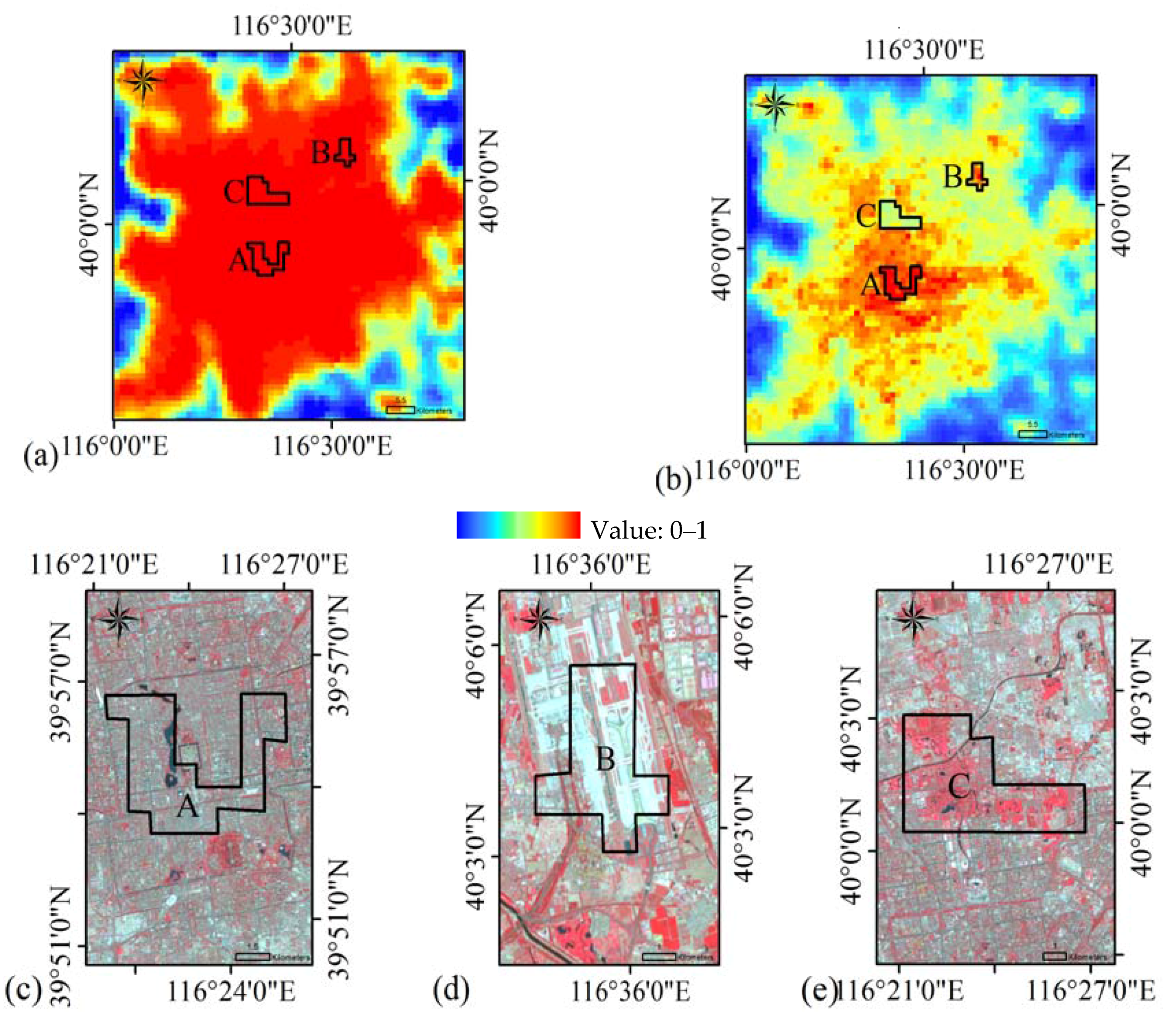
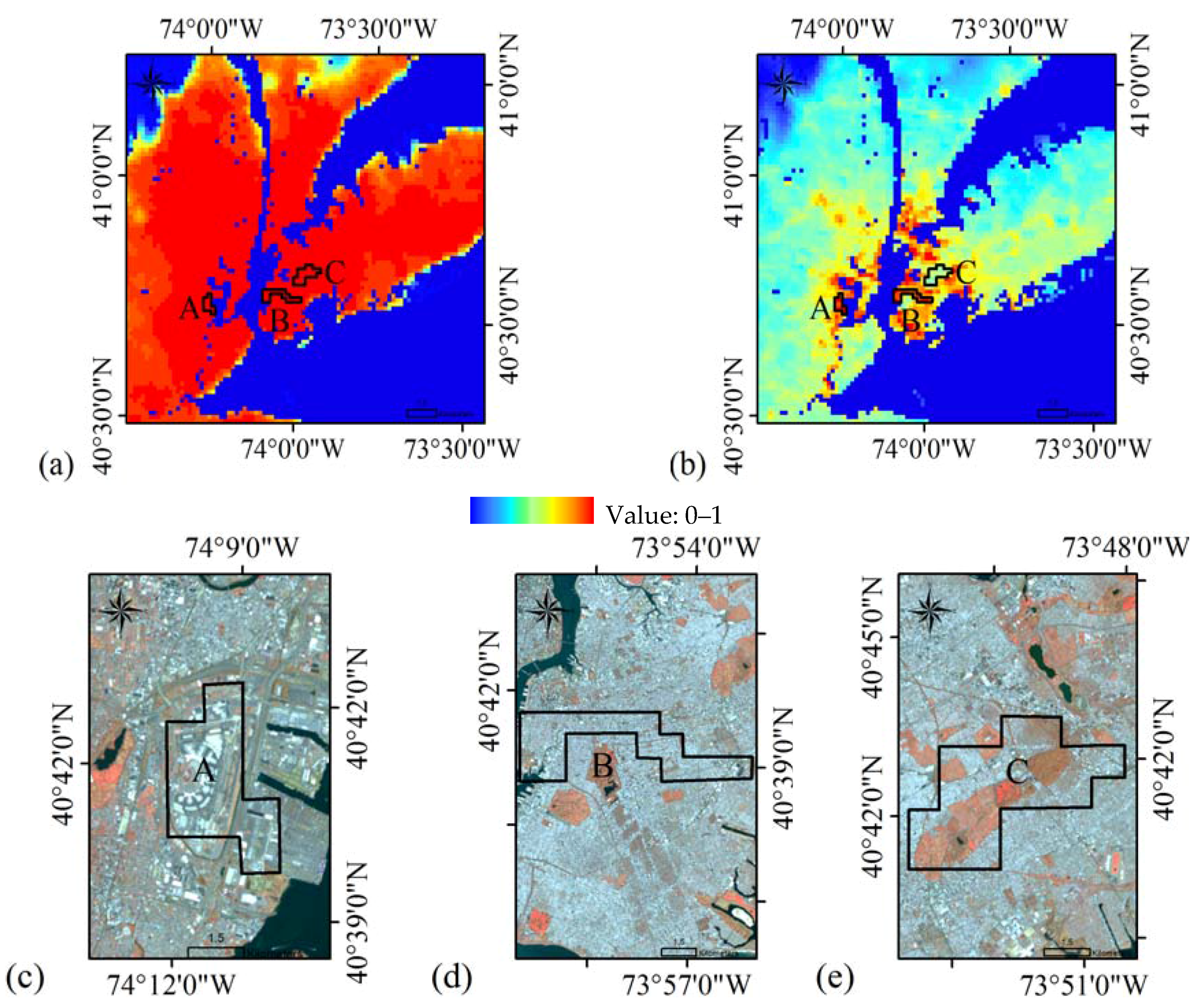
- The Landsat 8 OLI image data with a 30 m spatial resolution was compared separately with both high and low LERNCI regional values in NTL-saturated city areas to validate the matching status in different urban function areas.
- (2)
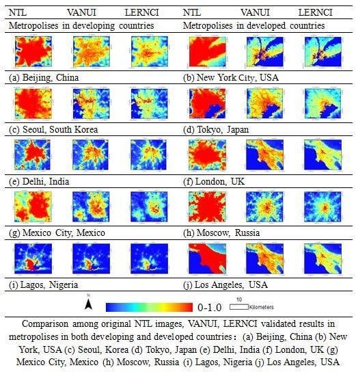
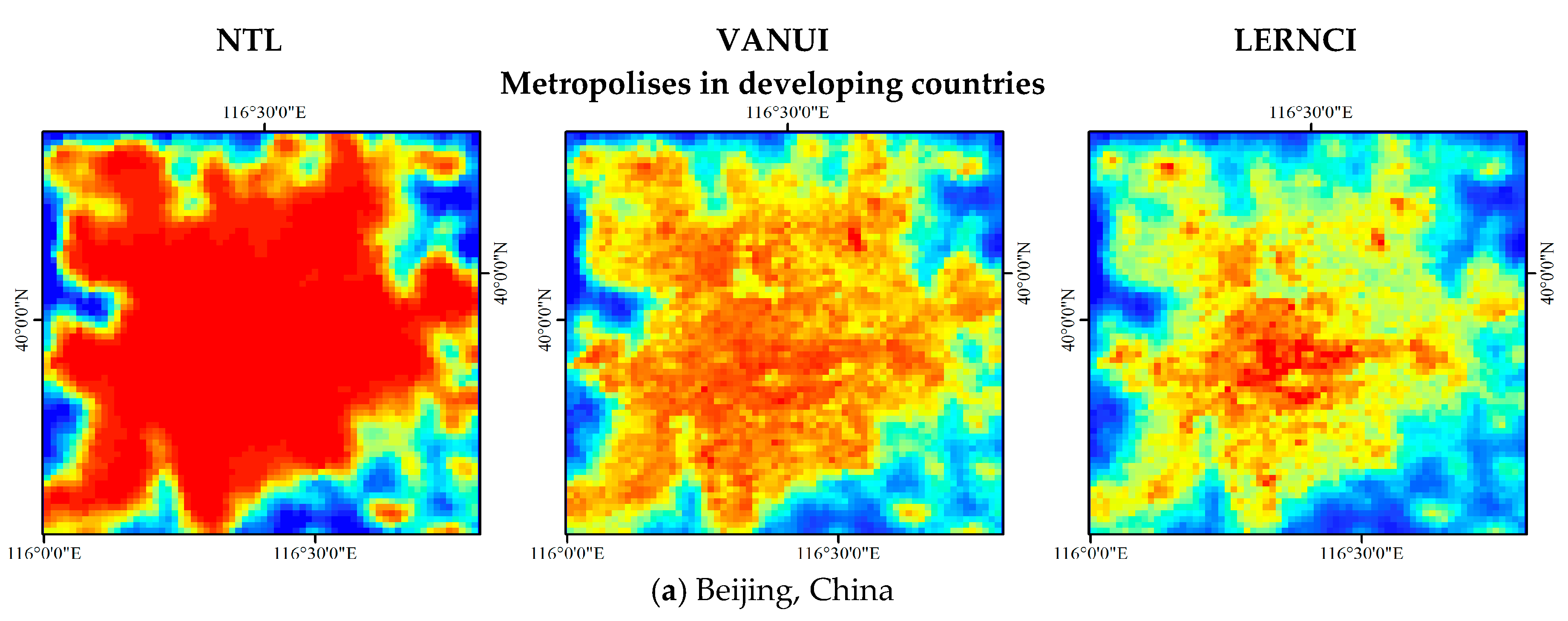
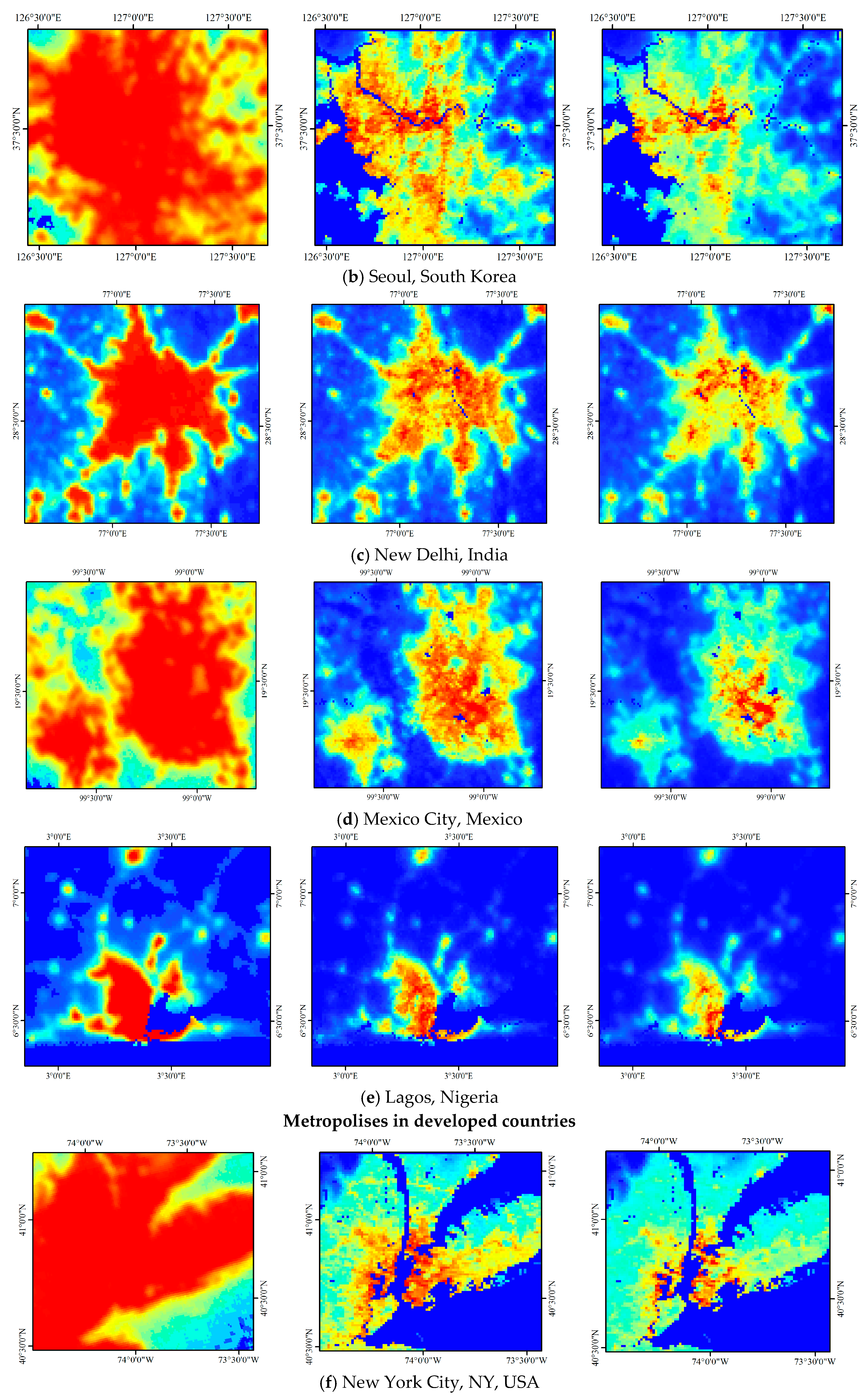
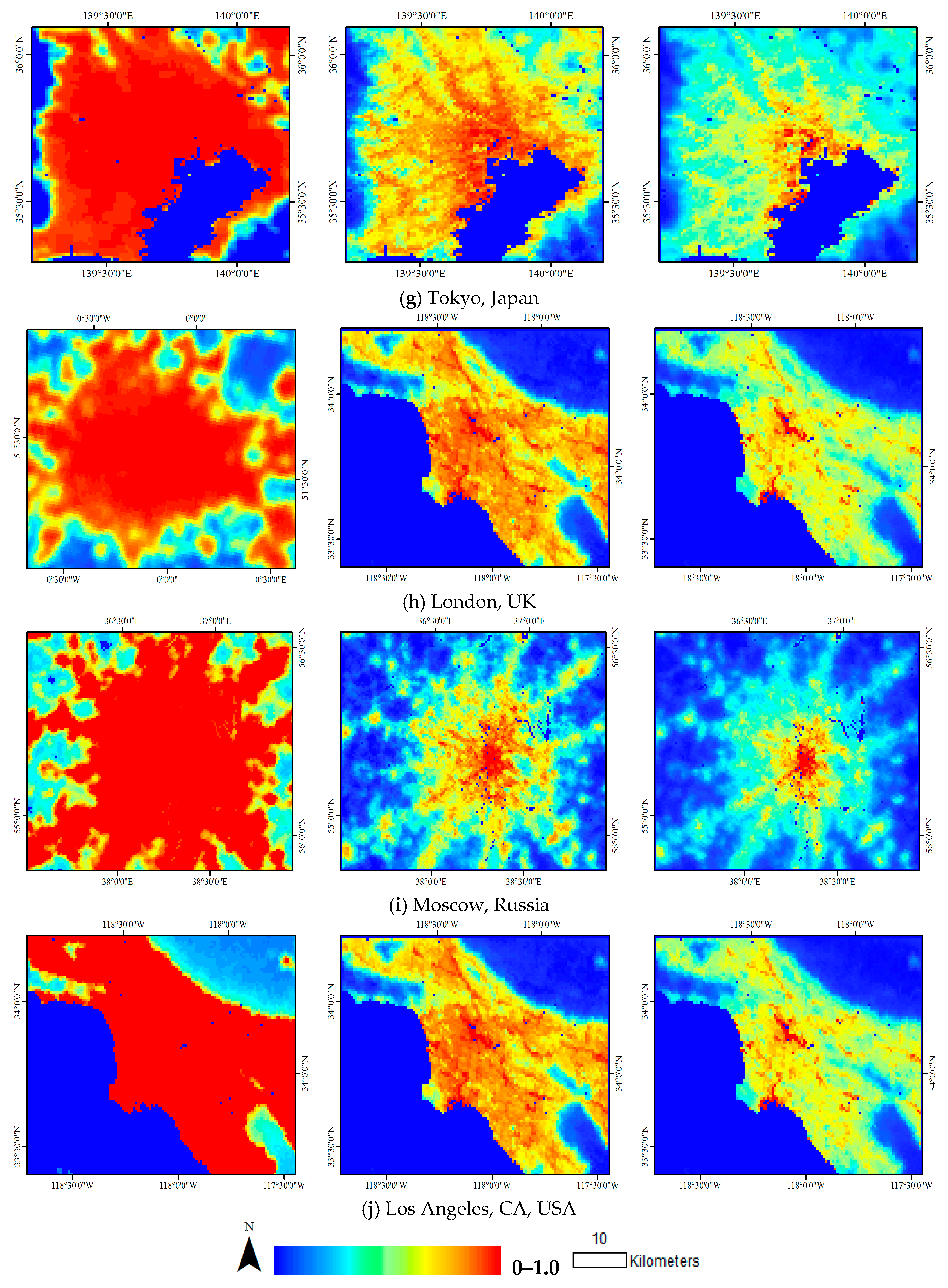
- We selected typical NTL-saturated urban regions from countries in Asia, North America, Africa and Europe and obtained the LERNCI and VANUI of each sample region. By doing so, comparisons could possibly validate the saturation-lowering effect of LERNCI over regions at different latitudes and climatic zones. Additionally, LERNCI could also be used to show the increasing regional trends in the saturated domain of NTL-saturated urban cores, both in develo** and developed countries. In recent decades, metropolises in develo** countries have experienced significant changes in vegetation-cover patterns due to rapid economic development. At the same time, large cities in developed countries have already gained long-term stability of vegetation-cover patterns at NTL-saturated urban regions.
- (3)
- The linear regression equations were established between LERNCI, VANUI and NPP/VIIRS DNB data. Then, the correlation coefficients of LERNCI, VANUI and DNB data were calculated and compared to validate the correspondence among LERNCI, VANUI, and NPP/VIIRS DNB datasets.
- (4)
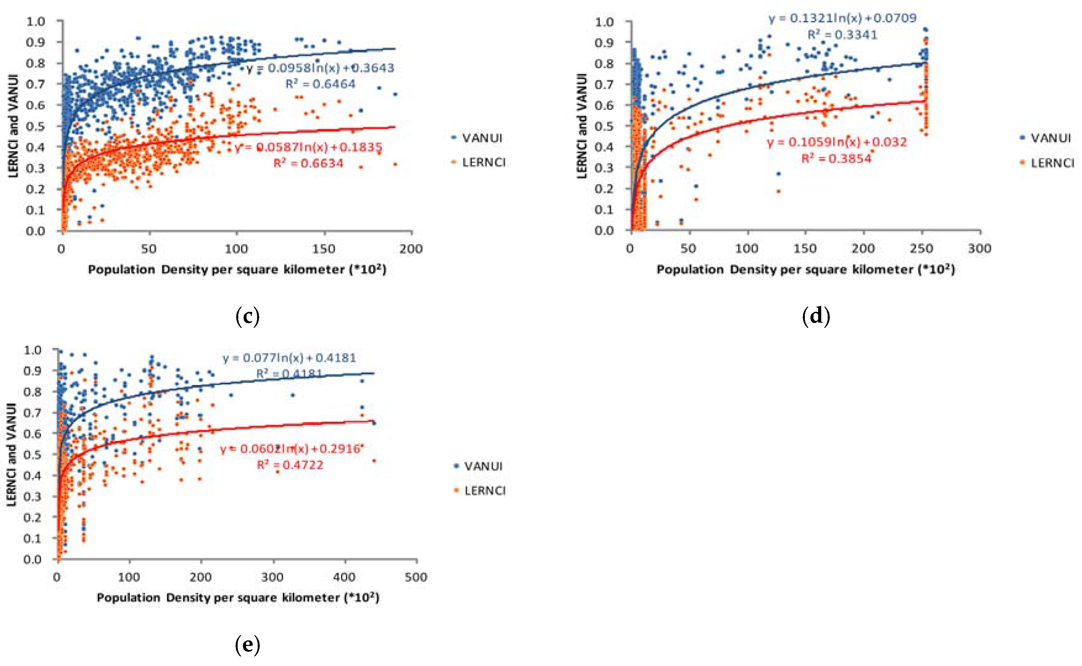
- Since nighttime luminance could mirror the spatial distribution of human productive activities and aggregation, parameter-adjusted, non-saturated nighttime pixel values could also be suggested to have a corresponding correlation with population density. A series of sample pixels were randomly selected to evaluate the correspondence among LERNCI, VANUI, and demographic distribution data from WorldPop which is an open-access archive of global-scale spatial demographic distributions.
4. Results and Analysis
4.1. LERNCI for Delineating the Internal Structures of Cities
4.2. Visual Comparison of NTL, VANUI and LERNCI
4.3. Correlation Analysis with NPP/VIIRS DNB Dataset
5. Discussion
6. Conclusions
Acknowledgments
Author Contributions


© 2017 by the authors. Licensee MDPI, Basel, Switzerland. This article is an open access article distributed under the terms and conditions of the Creative Commons Attribution (CC BY) license (http://creativecommons.org/licenses/by/4.0/).
Share and Cite
Liu, Y.; Yang, Y.; **g, W.; Yao, L.; Yue, X.; Zhao, X. A New Urban Index for Expressing Inner-City Patterns Based on MODIS LST and EVI Regulated DMSP/OLS NTL. Remote Sens. 2017, 9, 777. https://doi.org/10.3390/rs9080777
Liu Y, Yang Y, **g W, Yao L, Yue X, Zhao X. A New Urban Index for Expressing Inner-City Patterns Based on MODIS LST and EVI Regulated DMSP/OLS NTL. Remote Sensing. 2017; 9(8):777. https://doi.org/10.3390/rs9080777
Chicago/Turabian StyleLiu, Yangxiaoyue, Ya** Yang, Wenlong **g, Ling Yao, **afang Yue, and **aodan Zhao. 2017. "A New Urban Index for Expressing Inner-City Patterns Based on MODIS LST and EVI Regulated DMSP/OLS NTL" Remote Sensing 9, no. 8: 777. https://doi.org/10.3390/rs9080777