1. Introduction
Coal is China’s main energy, accounting for more than 55% of the total primary energy consumption, and it plays a strategic role in long-term development [
1,
2,
3]. While coal mining has brought benefits, it has also led to land and ecological environmental damages [
4]. For example, underground mining leads to numerous issues, such as ground subsidence [
5,
6], damage to land and vegetation [
7,
8], and the destruction of landscapes [
9,
10,
11]. As 96% of China’s coal mining is underground mining, this leads to a significant amount of land subsidence damage [
12,
13,
14]. According to statistics, the accumulated area of coal mining subsidence in China has reached 1.35 × 10
6 ha, and it is still rising at an annual rate of 7.0 × 10
4 ha [
15]. Most subsided land is distributed in plain areas with high groundwater levels in eastern China [
16]. After ground subsidence, high-level groundwater quickly rises above the ground elevation, resulting in a large amount of surface water [
17,
18].
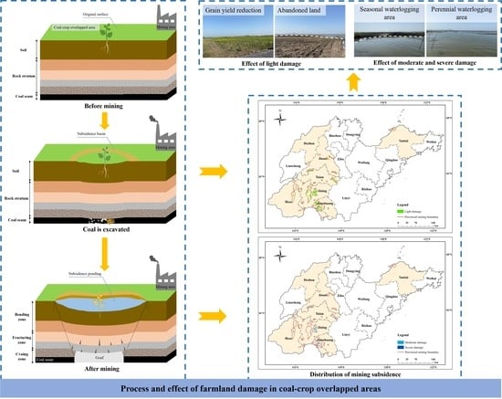
Coal subsidence areas with high groundwater levels in China are also primary coal and grain production areas, i.e., areas where the coal–crop overlap** area (COA) [
19]. COA account for 42.7% of the total cropland in China [
20], 90% of which are high-yield agricultural areas in the Huang-Huai-Hai region [
21]. Coal mining subsidence causes a large amount of perennial or seasonal water accumulation on high-quality cropland, resulting in a substantial reduction, or total failure, in cropland production [
22]. Other resulting problems include lost farming land [
23], increasingly prominent human–land conflicts [
24,
25], and severe agricultural economic losses, which can seriously affect the coordinated development of the society, economy, and ecology in mining areas [
26,
27,
28,
29]. Therefore, studying the destruction of farmland in coal–cropland overlap** areas and its impact will help manage the contradiction between coal mining and cropland protection and ease the pressure on national food security and population.
Hitherto, research on the problem of coal–grain complex areas mainly focuses on farmland damage, farmland protection, land reclamation, and ecological evaluation. In terms of farmland damage, Hu et al. [
30] and Li et al. [
31] explored the overlap** characteristics of coal and grain, damaged cropland, and its impact on coal–grain composite areas in five eastern provinces and typical municipalities. Song et al. [
32] designed an evolution prediction information system, and Zhao et al. [
33] categorized the damage level of cropland by constructing an evaluation index system. Additionally, Shi et al. [
34] and Chen et al. [
35] analyzed the evolving trend of cultivated land in the primary coal and grain production areas. In terms of cultivated land protection, Hu et al. [
20,
21] discussed the issues of environmental quality and food security in overlapped areas. Yan et al. [
36] and Gao et al. [
37] put forward suggestions for essential cropland protection based on the analysis of the damage characteristics of cropland. In terms of ecological evaluation, Yang et al. [
38] researched the spatial pattern and evolution characteristics of the cultivated land ecosystem in overlapped areas, and Li et al. [
39] estimated the changes in the ecological service value of the composite coal–grain regions. Wang et al. [
40] identified the multi-functionality of land use from production–living–ecology aspects. Ma et al. [
41] explored the characteristics of temporal and spatial changes and the influencing factors of landscape ecological quality in overlapped areas.
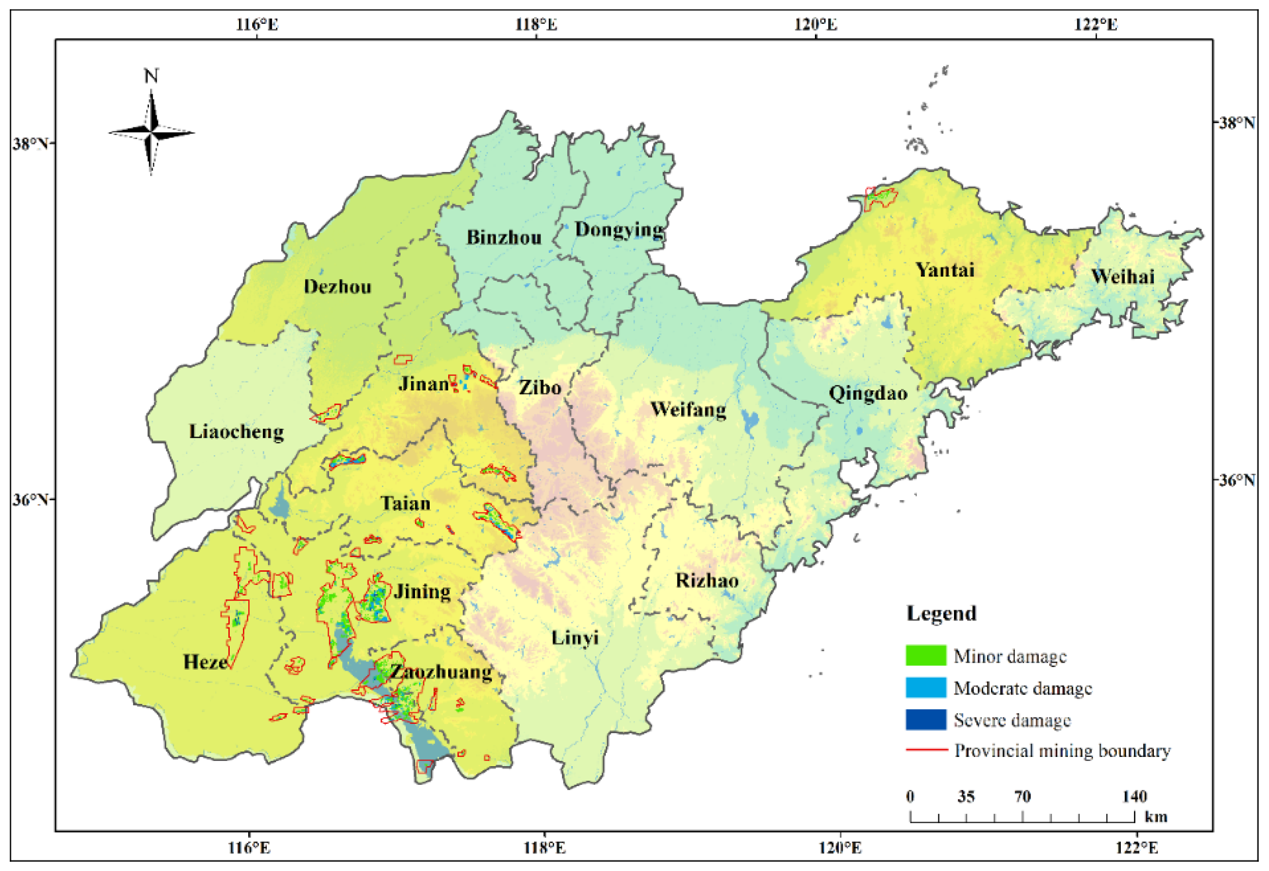
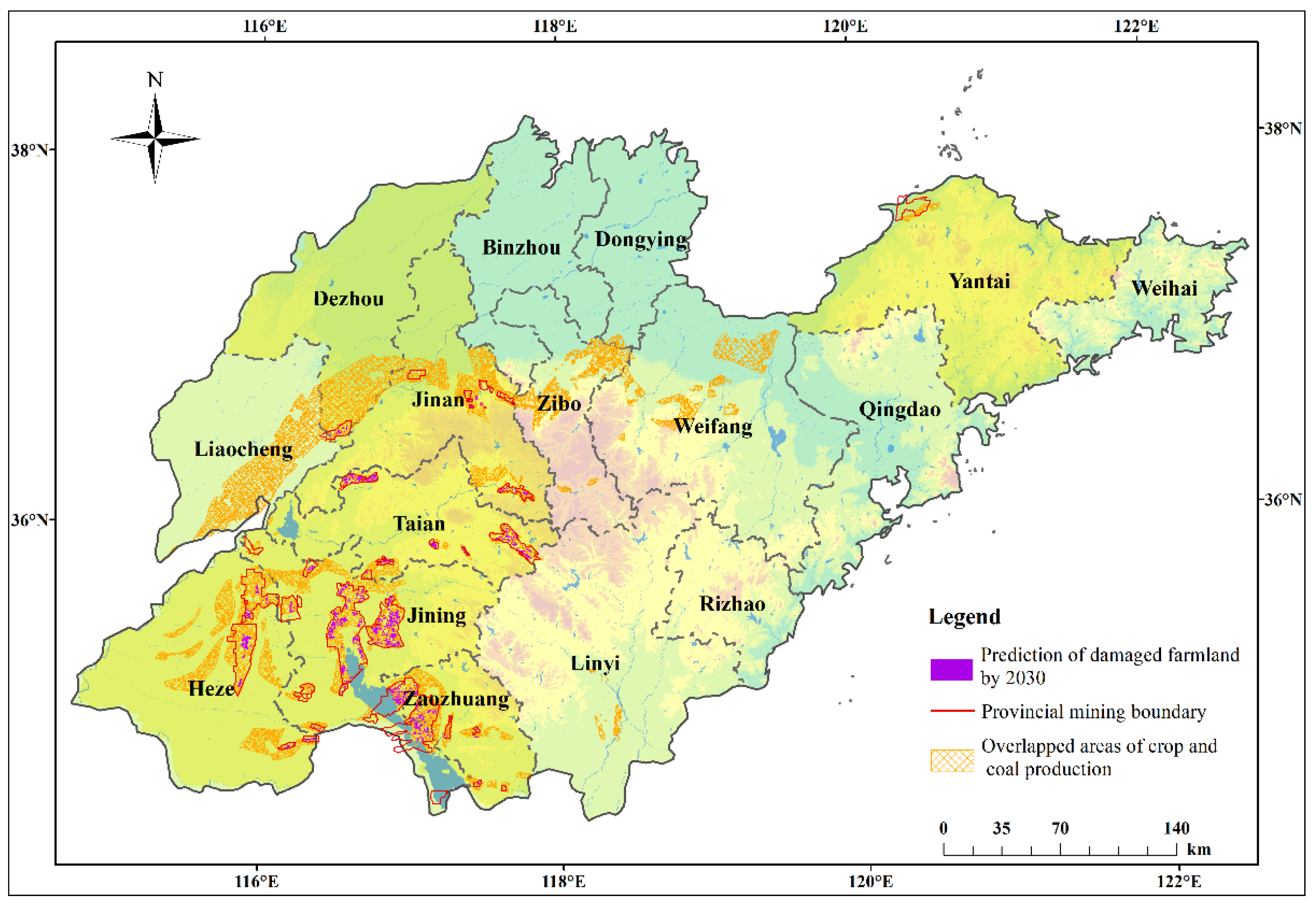
Previous studies on cropland damage and its impact on COA have mostly been on a national, municipal, or county scale, and analysis at a provincial level is rare. Moreover, the amount of farmland damage caused by mining subsidence in large-scale areas is only estimated based on empirical models (such as the ever ratio of subsidence land method). In addition, little research has focused on the temporal and spatial changes of farmland damage in overlapped areas. To supplement existing research results, this study used the prediction software based on the probability integral method from the provincial scale to analyze the spatiotemporal impact of coal mining on farmland in COA.
In summary, the objectives of this study are: (1) to analyze the current situation of cropland damage caused by mining subsidence in Shandong Province, a representative agricultural and coal production area in eastern China; (2) to use the principle of a probability integral method of mining subsidence to reveal the evolution of cropland damage in multiple areas in Shandong Province; (3) to assess and analyze the impact of farmland damage on grain yield, farmland landscape pattern, and ecological environment, and discuss the impact on social stability based on field investigation and literature reading. Conclusions can be applied to COAs such as Illinois in the United States, Queensland in Australia, the Upper Silesia Coalfield in the Czech Republic and Poland, and coal-producing countries in Southeast Asia.
5. Conclusions
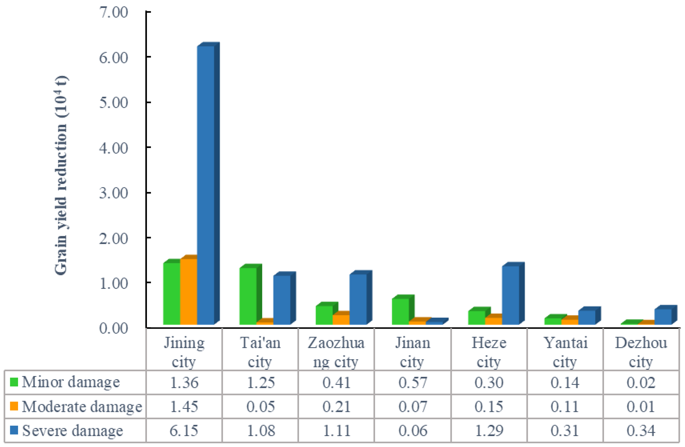
Coal and cropland resources in COA have a large overlapped area and a wide distribution range. Coal mining will inevitably cause a large amount of farmland damage. Based on the provincial scale, taking Shandong Province as an example, this paper analyzed the spatiotemporal impact of coal mining on cropland in coal–cropland overlap** areas. The research results suggest that the cropland area in overlapped regions will continue to decrease with the continuous exploitation of coal resources. The damage degree will continue to increase, seriously affecting local agriculture, the environment, and social stability. The research results lay a foundation for other coal–grain complex areas to clarify the current situation, trend, and mechanism of cropland damage. At the same time, gras** the temporal and spatial impact of mining on cropland in overlapped areas is also the premise and basis for formulating coordinated countermeasures for mining and cropland protection.
Therefore, it is recommended that relevant departments consider the following points when formulating grainland protection plans: (1) overlap** characteristics and evolution trends of damaged cropland should be fully considered. (2) Appropriate reclamation methods should be selected. Concurrent mining and reclamation technology can be promoted for areas with high groundwater levels to save more topsoil resources in advance. (3) It is necessary to rebuild the ecological environment according to local conditions. In addition, we should vigorously promote the green mining technology of coal mines to reduce the impact of coal mining subsidence from the source.
Given the limitations of this study, future research needs to pay more attention to how to reduce the error between the predicted damage and the actual damage and explore the impact mechanism of farmland damage on the mining area development to realize the sustainable development of coal mining and farmland protection.


