
Prediction of Groundwater Level Variations in a Changing Climate: A Danish Case Study


Abstract
:1. Introduction
1.1. Machine Learning for Groundwater Prediction
1.2. Study Objectives and Problem Statement
- How will the water table be affected by climate change in the future based on different socio-economic pathways (SSPs)?
- Do ML models perform well enough in predicting changes of the groundwater in Denmark? If so, which ML model outperforms for forecasting these changes?
2. Data and Materials
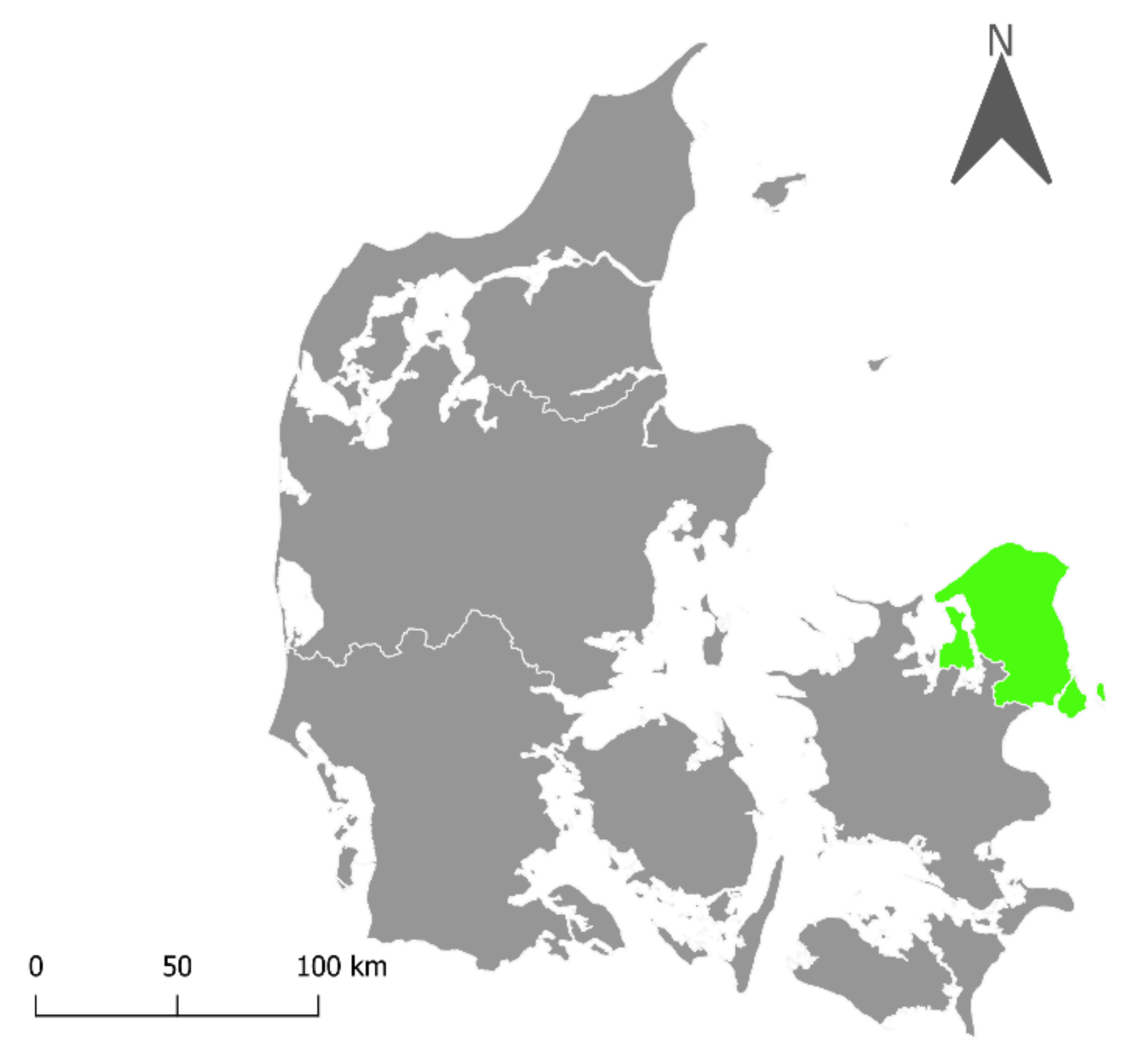
2.1. Study Area
2.2. Dependent Variable: Jupiter Database
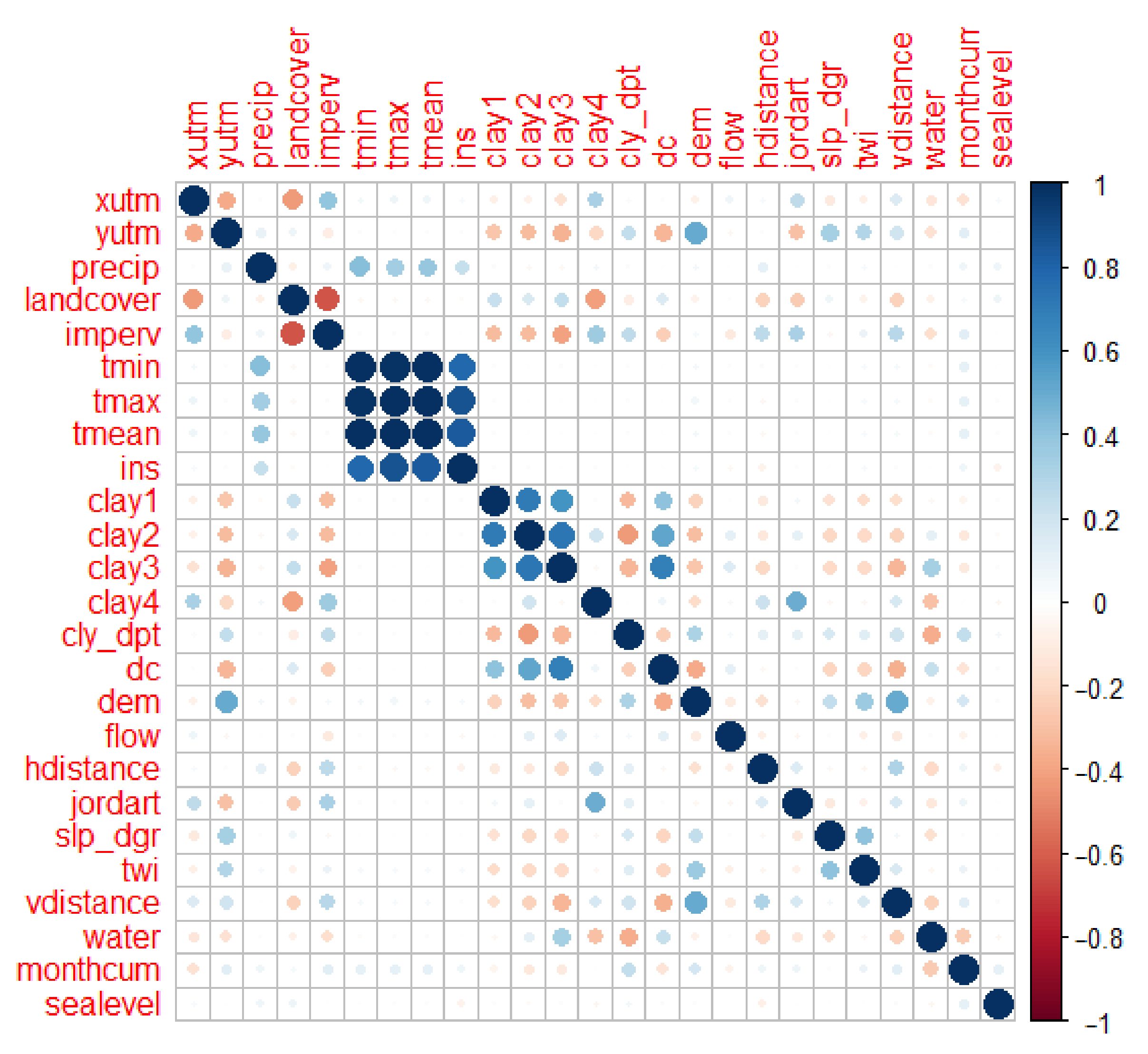
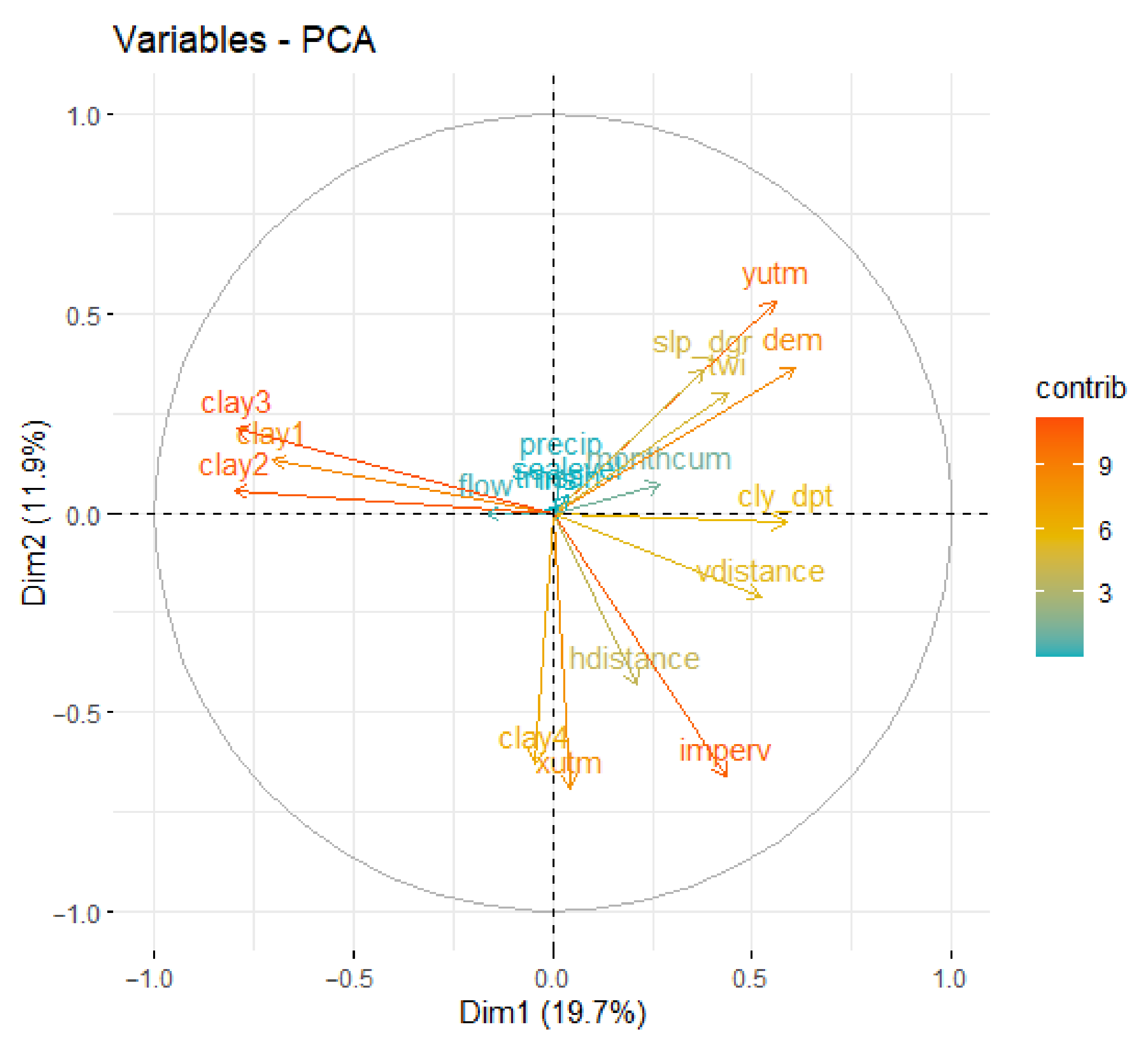
2.3. Independent Variables
3. Methods
3.1. Machine Learning Algorithms
3.1.1. Random Forest
3.1.2. Artificial Neural Networks
3.1.3. Support Vector Machines
3.2. Implementation
4. Results
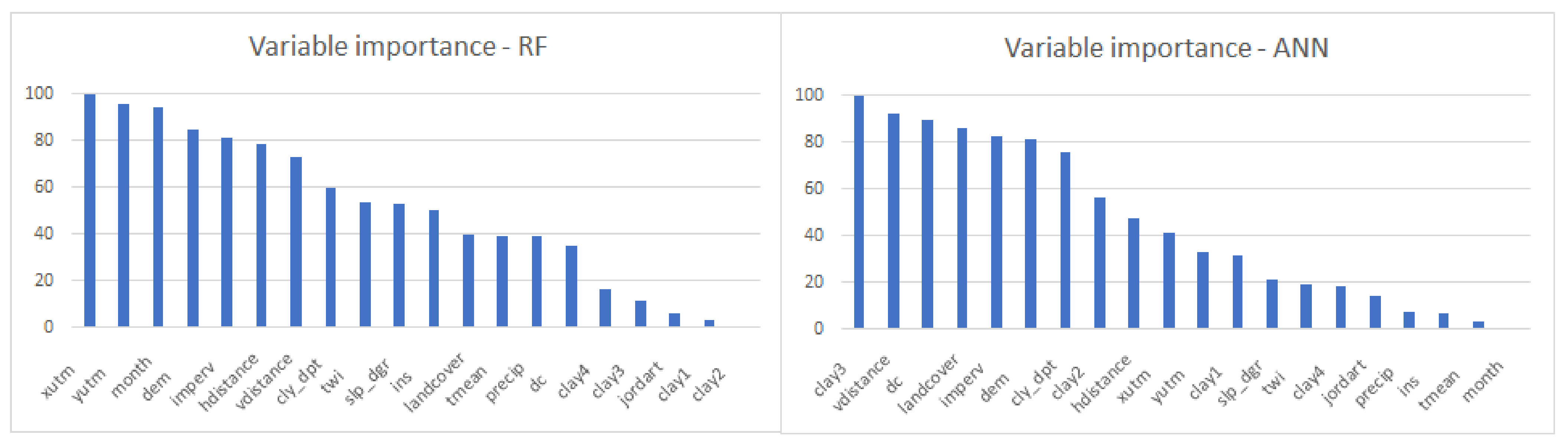
4.1. Comparison of the Models
4.2. Future Predictions
5. Discussion
5.1. Comparison of the Models
5.2. Future Predictions
5.3. Limitations of the Model
5.4. Limitations of the Data
5.5. Implications to Society and Decision Makers
6. Conclusions
7. Future Work
Author Contributions
Funding
Institutional Review Board Statement
Informed Consent Statement
Data Availability Statement
Acknowledgments
Conflicts of Interest
Appendix A


References
- Gleeson, T.; Befus, K.M.; Jasechko, S.; Luijendijk, E.; Cardenas, M.B. The global volume and distribution of modern groundwater. Nat. Geosci. 2016, 9, 161–167. [Google Scholar] [CrossRef]
- European Commission. Groundwater; Environment. 2021. Available online: https://ec.europa.eu/environment/water/water-framework/groundwater/resource.htm (accessed on 20 May 2021).
- Kahlown, M.A.; Ashraf, M. Effect of shallow groundwater table on crop water requirements and crop yields. Agric. Water Manag. 2005, 76, 24–35. [Google Scholar] [CrossRef]
- Zipper, S.C.; Soylu, M.E.; Booth, E.G.; Loheide, S.P. Untangling the effects of shallow groundwater and soil texture as drivers of subfield-scale yield variability. Water Resour. Res. 2015, 51, 6338–6358. [Google Scholar] [CrossRef] [Green Version]
- Jankowfsky, S.; Branger, F.; Braud, I.; Rodriguez, F.; Debionne, S.; Viallet, P. Assessing anthropogenic influence on the hydrology of small peri-urban catchments: Development of the object-oriented PUMMA model by integrating urban and rural hydrological models. J. Hydrol. 2014, 517, 1056–1071. [Google Scholar] [CrossRef]
- Collins, M.; Knutti, R.; Gutowski, W.J., Jr.; Brooks, H.E.; Shindell, D.; Webb, R. Long-Term Climate Change: Projections, Commitments and Irreversibility. In Climate Change 2013: The Physical Science Basis; Contribution of Working Group I to the Fifth Assessment Report of the Intergovernmental Panel on Climate Change; Stocker, T.F., Qin, D., Plattner, G.-K., Tignor, M., Allen, S.K., Boschung, J., Nauels, A., ** Climate Change—Barriers and Opportunities for Action; Task Force on Climate Change Adaptation: Washington, DC, USA, 2012. [Google Scholar]
- Lakshamanan, V.; Gilleland, E.; McGovern, A.; Tingley, M. Machine Learning and Data Mining Approaches to Climate Science; Springer: New York, NY, USA, 2015. [Google Scholar]
- Rolnick, D.; Donti, P.; Kaack, L.; Kochanski, K.; Lacoste, A.; Sankaran, K.; Ross, A.S.; Milojevic-Dupont, N.; Jaques, N.; Waldman-Brown, A.; et al. Tackling Climate Change with Machine Learning. ar** of Soil Texture in Denmark. Soil Sci. Soc. Am. J. 2013, 77, 860–876. [Google Scholar] [CrossRef]
- Møller, A.B.; Iversen, B.v.; Beucher, A.; Greve, M.H. Prediction of soil drainage classes in Denmark by means of decision tree classification. Geoderma 2019, 352, 314–329. [Google Scholar] [CrossRef]
- GEUS. Download jordartskort. De Nationale Geologiske Undersøgelser for Danmark og Grønland. 2021. Available online: https://www.geus.dk/produkter-ydelser-og-faciliteter/data-og-kort/danske-kort/download-jordartskort (accessed on 1 April 2021).
- Copernicus. EU-DEM v1.0. Copernicus Programme. 2021. Available online: https://land.copernicus.eu/imagery-in-situ/eu-dem/eu-dem-v1-0-and-derived-products/eu-dem-v1.0 (accessed on 1 April 2021).
- NOAA. Relative Sea Level Trend. National Oceanic and Atmospheric Administration. 2021. Available online: https://tidesandcurrents.noaa.gov/sltrends/sltrends_station.shtml?id=130-021 (accessed on 1 April 2021).
- Copernicus. CORINE Land Cover. Copernicus Programme. 2021. Available online: https://land.copernicus.eu/pan-european/corine-land-cover (accessed on 1 April 2021).
- Copernicus. Copernicus Land Monitoring Service-High Resolution Layers—Imperviousness. European Environment Information and Observation Network. 2021. Available online: https://www.eea.europa.eu/data-and-maps/data/copernicus-land-monitoring-service-imperviousness-2 (accessed on 1 April 2021).
- Harris, I.; Jones, P.D.; Osborn, T.J.; Lister, D.H. Updated high-resolution grids of monthly climatic—The CRU TS3.10 Dataset. Int. J. Climatol. 2014, 34, 11593–11610. [Google Scholar] [CrossRef] [Green Version]
- Fick, S.E.; Hijmans, R.J. WorldClim 2: New 1-km spatial resolution climate surfaces for global land areas. Int. J. Climatol. 2017, 37, 4302–4315. [Google Scholar] [CrossRef]
- Kuhn, M. The Caret Package 2019. Available online: https://topepo.github.io/caret/index.html (accessed on 23 May 2021).
- STHDA. Regression Analysis Essentials for Machine Learning. Statistical Tools for High-Throughput Data Analysis, 2021. Available online: http://www.sthda.com/english/wiki/regression-analysis-essentials-for-machine-learning (accessed on 15 May 2021).
- Breiman, L. Random forests. Mach. Learn. 2001, 45, 5–32. [Google Scholar] [CrossRef] [Green Version]
- Brownlee, J. Random Forest for Time Series Forecasting. Machine Learning Mastery. 2020. Available online: https://machinelearningmastery.com/random-forest-for-time-series-forecasting/ (accessed on 6 May 2021).
- Catani, F.; Lagomarsino, D.; Segoni, S.; Tofani, V. Landslide susceptibility estimation by random forests technique: Sensitivity and scaling issues. Nat. Hazards Earth Syst. Sci. 2013, 13, 2815–2831. [Google Scholar] [CrossRef] [Green Version]
- Frankenfield, J. Artificial Neural Network (ANN). Investopedia, 2020. Available online: https://www.investopedia.com/terms/a/artificial-neural-networks-ann.asp (accessed on 17 May 2021).
- Zhou, V. Machine Learning for Beginners: An Introduction to Neural Networks. Towards Data Science, 2019. Available online: https://towardsdatascience.com/machine-learning-for-beginners-an-introductionto-Neural-networks-d49f22d238f9 (accessed on 18 May 2021).
- Sayad, S. An Introduction to Data Science; Saedsayad: Toronto, ON, Canada, 2021; Available online: https://www.saedsayad.com/data_mining_map.htm (accessed on 5 May 2021).
- Hijmans, R.J. Package ‘Raster’. The Comprehensive R Archive Network. 2020. Available online: https://cran.rproject.org/web/packages/raster/raster.pdf (accessed on 23 May 2021).
- Dormann, C.F.; Elith, J.; Bacher, S.; Buchmann, C.; Carl, G.; Carré, G.; García Marquéz, J.R.; Gruber, B.; Lafourcade, B.; Leitão, P.J.; et al. Collinearity: A review of methods to deal with it and a simulation study evaluating their performance. Ecography 2013, 36, 27–46. [Google Scholar] [CrossRef]
- Meyer, H.; Reudenbach, C.; Hengl, T.; Katurji, M.; Nauss, T. Improving performance of spatio-temporal machine learning models using forward feature selection and target-oriented validation. Environ. Model. Softw. 2018, 101, 1–9. [Google Scholar] [CrossRef]
- Levin, G. Dynamics of Danish agricultural landscape and role of organic farming. Agric. Ecosyst. Environ. 2007, 120, 330–344. [Google Scholar] [CrossRef]
- Danish Agriculture & Food Council. Denmark—A Food and Farming Country; Danish Agriculture & Food Council: Copenhagen, Denmark, 2019. [Google Scholar]
- Robbach, P. Neural Networks vs. Random Forest—Does It always Have to Be Deep Learning? Frankfurt School of Finance and Management. 2018. Available online: https://blog.frankfurt-school.de/neural-networks-vs-random-forests-does-it-always-have-to-be-deep-learning/ (accessed on 16 May 2021).
- Henriksen, H.J.; Troldborg, L.; Nyegaard, P.; Sonnenborg, T.O.; Refsgaard, J.C.; Madsen, B. Methodology for construction, calibration and validation of a national hydrological model for Denmark. J. Hydrol. 2003, 280, 52–71. [Google Scholar] [CrossRef]
- GEUS. Groundwater Monitoring 1989–2017—Summary; GEUS: Copenhagen, Denmark, 2017. [Google Scholar]
- Miljø Metropolen. Copenhagen Climate Adaptation Plan; Miljø Metropolen: Copenhagen, Denmark, 2011. [Google Scholar]
- Fung, A.; Babcock, R. A Flow-Calibrated Method to Project Groundwater Infiltration into Coastal Sewers Affected by Sea Level Rise. Water 2020, 12, 1934. [Google Scholar] [CrossRef]


| Type/Group | Variable | Type | Resolution | Source |
|---|---|---|---|---|
| Geology | Clay content (1–4) | Continuous | 30 m | Adhikari et al. [48] |
| Depth to clay occurence | Continuous | 30 m | - | |
| Soil drainage class | Categorical | 30 m | Møller et al. [49] | |
| Soil type | Categorical | N/A | GEUS [50] | |
| Topography | DEM | Continuous | 25 m | Copernicus [51] |
| Topographic wetness index | Continuous | 25 m | - | |
| Flow accumulation | Continuous | 25 m | - | |
| Slope | Continuous | 25 m | - | |
| Incoming solar radiation | Continuous | 25 m | - | |
| Water | Horizontal distance to nearest waterbody | Continuous | 25 m | - |
| Vertical distance to nearest water body | Continuous | 25 m | - | |
| Water bodies (lakes, streams, etc.) | Categorical | Koch et al. [29] | ||
| Sea level | Continuous | N/A | NOAA [52] | |
| Land cover | Corine | Categorical | 100 m | Copernicus [53] |
| Imperviousness | Continuous | 20 m | Copernicus [54] | |
| Bioclimatic variables (monthly historical data) | Precipitation | Continuous | 4.5 km | Harris et al. [55] |
| Minimum temperature | Continuous | 4.5 km | ||
| Maximum temperature | Continuous | 4.5 km | ||
| Average temperature | Continuous | 4.5 km | ||
| Coordinates | xytm | Continuous | 25 m | - |
| yutm | Continuous | 25 m | - | |
| Bioclimatic variables–Future projections | Precipitation | Continuous | 4.5 km | Fick & Hijmans [56] |
| Average temperature | Continuous | 4.5 km |
| ML Model | R2 | RMSE (m) | MAE (m) |
|---|---|---|---|
| RF | 0.75 | 0.98 | 0.61 |
| ANN | 0.63 | 1.19 | 0.85 |
| SVM | 0.65 | 1.15 | 0.75 |
| Land Cover Type | R2 | MAE (m) |
|---|---|---|
| Urban | 0.70 | 0.63 |
| Agricultural | 0.65 | 0.69 |
| Nature | 0.86 | 0.38 |
| Scenario | Winter (%) | Summer (%) |
|---|---|---|
| 2018 | 1.40 | 1.26 |
| 2.4–5 | 1.40 | 1.25 |
| 3.7–0 | 1.43 | 1.29 |
| 5.8–5 | 1.43 | 1.41 |
| Winter | Summer | |||||
|---|---|---|---|---|---|---|
| Scenario | SSP 2.4-5 | SSP 3.7-0 | SSP 5.8-5 | SSP 2.4-5 | SSP 3.7-0 | SSP 5.8-5 |
| Max. rise (m) | +0.67 | +0.83 | +0.82 | +0.70 | +0.70 | +0.71 |
| Max. fall (m) | −0.52 | −0.47 | −0.49 | −0.52 | −0.49 | −0.52 |
Publisher’s Note: MDPI stays neutral with regard to jurisdictional claims in published maps and institutional affiliations. |
© 2021 by the authors. Licensee MDPI, Basel, Switzerland. This article is an open access article distributed under the terms and conditions of the Creative Commons Attribution (CC BY) license (https://creativecommons.org/licenses/by/4.0/).
Share and Cite
Gonzalez, R.Q.; Arsanjani, J.J. Prediction of Groundwater Level Variations in a Changing Climate: A Danish Case Study. ISPRS Int. J. Geo-Inf. 2021, 10, 792. https://doi.org/10.3390/ijgi10110792
Gonzalez RQ, Arsanjani JJ. Prediction of Groundwater Level Variations in a Changing Climate: A Danish Case Study. ISPRS International Journal of Geo-Information. 2021; 10(11):792. https://doi.org/10.3390/ijgi10110792
Chicago/Turabian StyleGonzalez, Rebeca Quintero, and Jamal Jokar Arsanjani. 2021. "Prediction of Groundwater Level Variations in a Changing Climate: A Danish Case Study" ISPRS International Journal of Geo-Information 10, no. 11: 792. https://doi.org/10.3390/ijgi10110792