Combination of Landsat 8 OLI and Sentinel-1 SAR Time-Series Data for Map** Paddy Fields in Parts of West and Central Java Provinces, Indonesia

 ,
, 
Abstract
:
1. Introduction
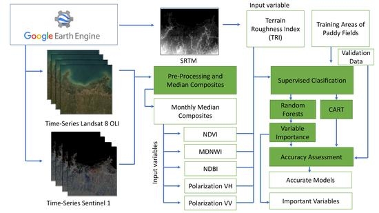
2. Materials and Methods
2.1. Study Area
2.2. Harmonic Regression for Landsat 8 OLI
2.3. Sentinel-1 Time Series Process
2.4. Ancillary Data
2.5. Classification and Accuracy Assessment
3. Results
3.1. Out-of-Bag Error (OOB) and Variable Importance
3.2. Classification Results and Accuracy Assessment
4. Discussion
5. Conclusions
Author Contributions
Funding
Acknowledgments
Conflicts of Interest
Appendix A

| RF_50 | |||||
|---|---|---|---|---|---|
| Class | Reference | UA | |||
| Paddy Field | Non-Paddy Field | Water Body | Total | ||
| Paddy Field | 860 | 144 | 0 | 1004 | 85.66 |
| Non-Paddy Field | 60 | 932 | 4 | 996 | 93.57 |
| Water Body | 0 | 18 | 982 | 1000 | 98.20 |
| Total | 920 | 1094 | 986 | 3000 | |
| PA | 93.48 | 85.19 | 99.59 | ||
| OA | 92.47 | ||||
| RF 80 | |||||
| Paddy Field | 843 | 140 | 0 | 1004 | 83.96 |
| Non-Paddy Field | 77 | 937 | 3 | 1017 | 92.13 |
| Water Body | 0 | 17 | 983 | 1000 | 98.30 |
| Total | 920 | 1094 | 986 | 3000 | |
| PA | 91.63 | 85.65 | 1.00 | ||
| OA | 92.10 | ||||
| CART | |||||
| Paddy Field | 744 | 133 | 0 | 1004 | 74.10 |
| Non-Paddy Field | 176 | 957 | 60 | 1193 | 80.22 |
| Water Body | 0 | 8 | 926 | 1000 | 92.60 |
| Total | 920 | 1098 | 986 | 3000 | |
| PA | 80.87 | 87.16 | 0.94 | ||
| OA | 87.57 | ||||
References
- Verburg, P.H.; Bouma, J. Land use change under conditions of high population pressure: The case of Java. Glob. Environ. Chang. 1999, 9, 303–312. [Google Scholar] [CrossRef]
- Firman, T. Major issues in Indonesia’s urban land development. Land Use Policy 2004, 21, 347–355. [Google Scholar] [CrossRef]
- Dimyati, M.; Mizuno, K.; Kobayashi, S.; Kitamura, T. An analysis of land use/cover change in Indonesia. Int. J. Remote Sens. 1996, 17, 931–944. [Google Scholar] [CrossRef]
- Dirman, E.; Saleng, A.; Sapiddin, A. Food agricultural land legal protection to improve food security in Indonesia. EES 2018, 196, 012047. [Google Scholar] [CrossRef]
- Wikkramatileke, R. Problems of Land-Use Map** in the Tropics. An Example from Ceylon. Geography 1959, 44, 79–95. [Google Scholar]
- Peng, D.; Huete, A.R.; Huang, J.; Wang, F.; Sun, H. Detection and estimation of mixed paddy rice crop** patterns with MODIS data. Int. J. Appl. Earth Obs. Geoinf. 2011, 13, 13–23. [Google Scholar] [CrossRef]
- ** paddy rice agriculture in South and Southeast Asia using multi-temporal MODIS images. Remote Sens. Environ. 2006, 100, 95–113. [J. Math. Fundam. Sci. 2010, 42, 91–106. [Google Scholar]
- Sakamoto, T.; Yokozawa, M.; Toritani, H.; Shibayama, M.; Ishitsuka, N.; Ohno, H. A crop phenology detection method using time-series MODIS data. Remote Sens. Environ. 2005, 96, 366–374. [Google Scholar] [CrossRef]
- Zhang, G.; ** paddy rice planting areas through time series analysis of MODIS land surface temperature and vegetation index data. ISPRS J. Photogramm. Remote Sens. 2015, 106, 157–171. [Int. J. Appl. Earth Obs. Geoinf. 2016, 46, 1–12. [Google Scholar]
- Zhang, Y.; Wang, C.; Wu, J.; Qi, J.; Salas, W.A. Map** paddy rice with multitemporal ALOS/PALSAR imagery in southeast China. Int. J. Remote Sens. 2009, 30, 6301–6315. [Google Scholar] [CrossRef]
- Miyaoka, K.; Maki, M.; Susaki, J.; Homma, K.; Noda, K.; Oki, K. Rice-planted area map** using small sets of multi-temporal SAR data. IEEE Geosci. Remote Sens. Lett. 2013, 10, 1507–1511. [Google Scholar] [CrossRef]
- Bazzi, H.; Baghdadi, N.; El Hajj, M.; Zribi, M.; Minh, D.H.T.; Ndikumana, E.; Courault, D.; Belhouchette, H. Map** paddy rice using Sentinel-1 SAR time series in Camargue, France. Remote Sens. 2019, 11, 887. [Google Scholar] [CrossRef] [Green Version]
- Kontgis, C.; Warren, M.S.; Skillman, S.W.; Chartrand, R.; Moody, D.I. Leveraging Sentinel-1 time-series data for map** agricultural land cover and land use in the tropics. In Proceedings of the 9th International Workshop on the Analysis of Multitemporal Remote Sensing Images (MultiTemp), Bruges, Belgium, 27–29 June 2017; pp. 1–4. [Google Scholar]
- Singha, M.; Dong, J.; Zhang, G.; ** double and single crop paddy rice with Sentinel-1A at varying spatial scales and polarizations in Hanoi, Vietnam. IEEE J. Sel. Top. Appl. Earth Obs. Remote Sens. 2018, 11, 498–512. [Google Scholar] [CrossRef]
- Nguyen, D.B.; Wagner, W. European rice cropland map** with Sentinel-1 data: The Mediterranean region case study. Water 2017, 9, 392. [Google Scholar] [CrossRef]
- Minasny, B.; Shah, R.M.; Che Soh, N.; Arif, C.; Indra Setiawan, B. Automated Near-Real-Time Map** and Monitoring of Rice Extent, Crop** Patterns, and Growth Stages in Southeast Asia Using Sentinel-1 Time Series on a Google Earth Engine Platform. Remote Sens. 2019, 11, 1666. [Google Scholar]
- Mansaray, L.R.; Huang, W.; Zhang, D.; Huang, J.; Li, J. Map** rice fields in urban Shanghai, southeast China, using Sentinel-1A and Landsat 8 datasets. Remote Sens. 2017, 9, 257. [Google Scholar] [CrossRef] [Green Version]
- Torbick, N.; Chowdhury, D.; Salas, W.; Qi, J. Monitoring rice agriculture across myanmar using time series Sentinel-1 assisted by Landsat-8 and PALSAR-2. Remote Sens. 2017, 9, 119. [Google Scholar] [CrossRef] [Green Version]
- Mansaray, L.R.; Wang, F.; Huang, J.; Yang, L.; Kanu, A.S. Accuracies of support vector machine and random forest in rice map** with Sentinel-1A, Landsat-8 and Sentinel-2A datasets. Geocarto Int. 2020, 35, 1088–1108. [Google Scholar] [CrossRef]
- Onojeghuo, A.O.; Blackburn, G.A.; Wang, Q.; Atkinson, P.M.; Kindred, D.; Miao, Y. Map** paddy rice fields by applying machine learning algorithms to multi-temporal Sentinel-1A and Landsat data. Int. J. Remote Sens. 2018, 39, 1042–1067. [Google Scholar] [CrossRef] [Green Version]
- Inoue, S.; Ito, A.; Yonezawa, C. Map** Paddy Fields in Japan by Using a Sentinel-1 SAR Time Series Supplemented by Sentinel-2 Images on Google Earth Engine. Remote Sens. 2020, 12, 1622. [Google Scholar] [CrossRef]
- Cai, Y.; Lin, H.; Zhang, M. Map** paddy rice by the object-based random forest method using time series Sentinel-1/Sentinel-2 data. Adv. Space Res. 2019, 64, 2233–2244. [Google Scholar] [CrossRef]
- Gorelick, N.; Hancher, M.; Dixon, M.; Ilyushchenko, S.; Thau, D.; Moore, R. Google Earth Engine: Planetary-scale geospatial analysis for everyone. Remote Sens. Environ. 2017, 202, 18–27. [Google Scholar] [CrossRef]
- Kumar, L.; Mutanga, O. Google Earth Engine applications since inception: Usage, trends, and potential. Remote Sens. 2018, 10, 1509. [Google Scholar] [CrossRef] [Green Version]
- Tamiminia, H.; Salehi, B.; Mahdianpari, M.; Quackenbush, L.; Adeli, S.; Brisco, B. Google Earth Engine for geo-big data applications: A meta-analysis and systematic review. ISPRS J. Photogramm. Remote Sens. 2020, 164, 152–170. [Google Scholar] [CrossRef]
- Dong, J.; ** paddy rice planting area in northeastern Asia with Landsat 8 images, phenology-based algorithm and Google Earth Engine. Remote Sens. Environ. 2016, 185, 142–154. [Google Scholar] [CrossRef]
- Weiss, D.J.; Atkinson, P.M.; Bhatt, S.; Mappin, B.; Hay, S.I.; Gething, P.W. An effective approach for gap-filling continental scale remotely sensed time-series. ISPRS J. Photogramm. Remote Sens. 2014, 98, 106–118. [Google Scholar] [CrossRef] [Green Version]
- Kandasamy, S.; Baret, F.; Verger, A.; Neveux, P.; Weiss, M. A comparison of methods for smoothing and gap filling time series of remote sensing observations-application to MODIS LAI products. Biogeosciences 2013, 10, 4055–4071. [Google Scholar] [CrossRef] [Green Version]
- Roy, D.P.; Yan, L. Robust Landsat-based crop time series modelling. Remote Sens. Environ. 2020, 238. [Google Scholar] [CrossRef]
- Roerink, G.; Menenti, M.; Verhoef, W. Reconstructing cloudfree NDVI composites using Fourier analysis of time series. Int. J. Remote Sens. 2000, 21, 1911–1917. [Google Scholar] [CrossRef]
- Brooks, E.B.; Thomas, V.A.; Wynne, R.H.; Coulston, J.W. Fitting the multitemporal curve: A Fourier series approach to the missing data problem in remote sensing analysis. IEEE Trans. Geosci. Remote Sens. 2012, 50, 3340–3353. [Google Scholar] [CrossRef] [Green Version]
- Liu, J.; Heiskanen, J.; Maeda, E.E.; Pellikka, P.K. Burned area detection based on Landsat time series in savannas of southern Burkina Faso. Int. J. Appl. Earth Obs. Geoinf. 2018, 64, 210–220. [Google Scholar] [CrossRef] [Green Version]
- Venkatappa, M.; Sasaki, N.; Shrestha, R.P.; Tripathi, N.K.; Ma, H.-O. Determination of vegetation thresholds for assessing land use and land use changes in Cambodia using the Google Earth Engine cloud-computing platform. Remote Sens. 2019, 11, 1514. [Google Scholar] [CrossRef] [Green Version]
- Derwin, J.M.; Thomas, V.A.; Wynne, R.H.; Coulston, J.W.; Liknes, G.C.; Bender, S.; Blinn, C.E.; Brooks, E.B.; Ruefenacht, B.; Benton, R. Estimating tree canopy cover using harmonic regression coefficients derived from multitemporal Landsat data. Int. J. Appl. Earth Obs. Geoinf. 2020, 86, 101985. [Google Scholar] [CrossRef]
- Landmann, T.; Eidmann, D.; Cornish, N.; Franke, J.; Siebert, S. Optimizing harmonics from Landsat time series data: The case of map** rainfed and irrigated agriculture in Zimbabwe. Remote Sens. Lett. 2019, 10, 1038–1046. [Google Scholar] [CrossRef]
- Surjasa, D.; Gumbira-Sa’id, E.; Arifin, B.; Jie, F. Indonesian rice supply chain analysis and supplier selection model. Int. J. Inf. Bus. Manag. 2013, 5, 198. [Google Scholar]
- Febrina, W.D. Determinants of Paddy Field Conversion in Java 1995-2013. J. Home Aff. Gov. 2017, 9, 1–13. [Google Scholar] [CrossRef] [Green Version]
- Poortinga, A.; Tenneson, K.; Shapiro, A.; Nquyen, Q.; San Aung, K.; Chishtie, F.; Saah, D. Map** plantations in Myanmar by fusing landsat-8, sentinel-2 and sentinel-1 data along with systematic error quantification. Remote Sens. 2019, 11, 831. [Google Scholar] [CrossRef] [Green Version]
- Soenen, S.A.; Peddle, D.R.; Coburn, C.A. SCS+ C: A modified sun-canopy-sensor topographic correction in forested terrain. IEEE Trans. Geosci. Remote Sens. 2005, 43, 2148–2159. [Google Scholar] [CrossRef]
- Gu, D.; Gillespie, A. Topographic normalization of Landsat TM images of forest based on subpixel sun–canopy–sensor geometry. Remote Sens. Environ. 1998, 64, 166–175. [Google Scholar] [CrossRef]
- Teillet, P.; Guindon, B.; Goodenough, D. On the slope-aspect correction of multispectral scanner data. Can. J. Remote Sens. 1982, 8, 84–106. [Google Scholar] [CrossRef] [Green Version]
- Han-Qiu, X. A study on information extraction of water body with the modified normalized difference water index (MNDWI). J. Remote Sens. 2005, 5, 589–595. [Google Scholar]
- Zha, Y.; Gao, J.; Ni, S. Use of normalized difference built-up index in automatically map** urban areas from TM imagery. Int. J. Remote Sens. 2003, 24, 583–594. [Google Scholar] [CrossRef]
- Benbahria, Z.; Sebari, I.; Hajji, H.; Smiej, M.F. Automatic Map** of Irrigated Areas in Mediteranean Context Using Landsat 8 Time Series Images and Random Forest Algorithm. In Proceedings of the IGARSS IEEE International Geoscience and Remote Sensing Symposium, Valencia, Spain, 22–27 July 2018; pp. 7986–7989. [Google Scholar]
- Ramanathan, K.; Thenmozhi, M.; George, S.; Anandan, S.; Veeraraghavan, B.; Naumova, E.N. Assessing Seasonality Variation with Harmonic Regression: Accommodations for Sharp Peaks. Int. J. Environ. Res. Public Health 2020, 17, 1318. [Google Scholar] [CrossRef] [Green Version]
- Clinton, N. Lab 6: Time series analysis. In Introductory Remote Sensing Code Labs; Geospatial Analysis Lab, University of San Francisco: San Francisco, CA, USA, 2019. [Google Scholar]
- Adams, B.; Iverson, L.; Matthews, S.; Peters, M.; Prasad, A.; Hix, D. Map** Forest Composition with Landsat Time Series: An Evaluation of Seasonal Composites and Harmonic Regression. Remote Sens. 2020, 12, 610. [Google Scholar] [CrossRef] [Green Version]
- Wilson, B.T.; Knight, J.F.; McRoberts, R.E. Harmonic regression of Landsat time series for modeling attributes from national forest inventory data. ISPRS J. Photogramm. Remote Sens. 2018, 137, 29–46. [Google Scholar] [CrossRef]
- Nguyen, M.D.; Baez-Villanueva, O.M.; Bui, D.D.; Nguyen, P.T.; Ribbe, L. Harmonization of Landsat and Sentinel 2 for Crop Monitoring in Drought Prone Areas: Case Studies of Ninh Thuan (Vietnam) and Bekaa (Lebanon). Remote Sens. 2020, 12, 281. [Google Scholar] [CrossRef] [Green Version]
- Fahsi, A.; Tsegaye, T.; Tadesse, W.; Coleman, T. Incorporation of digital elevation models with Landsat-TM data to improve land cover classification accuracy. For. Ecol. Manag. 2000, 128, 57–64. [Google Scholar] [CrossRef]
- Saha, A.; Arora, M.; Csaplovics, E.; Gupta, R. Land cover classification using IRS LISS III image and DEM in a rugged terrain: A case study in Himalayas. Geocarto Int. 2005, 20, 33–40. [Google Scholar] [CrossRef]
- Riley, S.J.; DeGloria, S.D.; Elliot, R. Index that quantifies topographic heterogeneity. Intermt. J. Sci. 1999, 5, 23–27. [Google Scholar]
- Breiman, L. Random forests. Mach. Learn. 2001, 45, 5–32. [Google Scholar] [CrossRef] [Green Version]
- Breiman, L. Out-of-bag Estimation. 1996. Available online: https://www.stat.berkeley.edu/~breiman/OOBestimation.pdf (accessed on 25 September 2020).
- Breiman, L.; Friedman, J.; Olshen, R.; Stone, C. Classification and Regression Trees; Chapman and Hall/CRC: Boca Raton, FL, USA, 1984. [Google Scholar]
- Bel, L.; Allard, D.; Laurent, J.; Cheddadi, R.; Bar-Hen, A. CART algorithm for spatial data: Application to environmental and ecological data. Comput. Stat. Data Anal. 2009, 53, 3082–3093. [Google Scholar] [CrossRef]
- Kuenzer, C.; Knauer, K. Remote sensing of rice crop areas. Int. J. Remote Sens. 2013, 34, 2101–2139. [Google Scholar] [CrossRef]
- Zhao, S.; Liu, X.; Ding, C.; Liu, S.; Wu, C.; Wu, L.J.G.; Sensing, R. Map** rice paddies in complex landscapes with convolutional neural networks and phenological metrics. Gisci. Remote Sens. 2020, 57, 37–48. [Google Scholar] [CrossRef]
- Ndikumana, E.; Ho Tong Minh, D.; Baghdadi, N.; Courault, D.; Hossard, L. Deep recurrent neural network for agricultural classification using multitemporal SAR Sentinel-1 for Camargue, France. Remote Sens. 2018, 10, 1217. [Google Scholar] [CrossRef] [Green Version]
- Crisóstomo de Castro Filho, H.; Abílio de Carvalho Júnior, O.; Ferreira de Carvalho, O.L.; Pozzobon de Bem, P.; dos Santos de Moura, R.; Olino de Albuquerque, A.; Rosa Silva, C.; Guimarães Ferreira, P.H.; Fontes Guimarães, R.; Trancoso Gomes, R.A. Rice Crop Detection Using LSTM, Bi-LSTM, and Machine Learning Models from Sentinel-1 Time Series. Remote Sens. 2020, 12, 2655. [Google Scholar] [CrossRef]
- Pelletier, C.; Webb, G.I.; Petitjean, F. Temporal convolutional neural network for the classification of satellite image time series. Remote Sens. 2019, 11, 523. [Google Scholar] [CrossRef] [Green Version]


| Data | Variables | Codename * | Number Variables |
|---|---|---|---|
| Landsat 8 | Harmonic-fitted NDVI | FNDVI1 to FNDVI12 | 12 |
| Harmonic-fitted MNDWI | FMNDWI1 to FMNDWI12 | 12 | |
| Harmonic-fitted NDBI | FNDBI1 to FNDBI12 | 12 | |
| Sentinel-1 | VV Polarization | VV1 to VV12 | 12 |
| VH Polarization | VH1 to VH12 | 12 | |
| SRTM | Terrain Ruggedness Index | TRI | 1 |
| Pixel Dimension: 867 × 480 pixels | Total Layer | 61 | |
| Model | PA (%) | UA (%) | OA (%) |
|---|---|---|---|
| CART | 80.87 | 84.83 | 87.57 |
| RF50 | 93.48 | 85.66 | 92.47 |
| RF80 | 91.63 | 85.76 | 92.10 |
Publisher’s Note: MDPI stays neutral with regard to jurisdictional claims in published maps and institutional affiliations. |
© 2020 by the authors. Licensee MDPI, Basel, Switzerland. This article is an open access article distributed under the terms and conditions of the Creative Commons Attribution (CC BY) license (http://creativecommons.org/licenses/by/4.0/).
Share and Cite
Arjasakusuma, S.; Swahyu Kusuma, S.; Rafif, R.; Saringatin, S.; Wicaksono, P. Combination of Landsat 8 OLI and Sentinel-1 SAR Time-Series Data for Map** Paddy Fields in Parts of West and Central Java Provinces, Indonesia. ISPRS Int. J. Geo-Inf. 2020, 9, 663. https://doi.org/10.3390/ijgi9110663
Arjasakusuma S, Swahyu Kusuma S, Rafif R, Saringatin S, Wicaksono P. Combination of Landsat 8 OLI and Sentinel-1 SAR Time-Series Data for Map** Paddy Fields in Parts of West and Central Java Provinces, Indonesia. ISPRS International Journal of Geo-Information. 2020; 9(11):663. https://doi.org/10.3390/ijgi9110663
Chicago/Turabian StyleArjasakusuma, Sanjiwana, Sandiaga Swahyu Kusuma, Raihan Rafif, Siti Saringatin, and Pramaditya Wicaksono. 2020. "Combination of Landsat 8 OLI and Sentinel-1 SAR Time-Series Data for Map** Paddy Fields in Parts of West and Central Java Provinces, Indonesia" ISPRS International Journal of Geo-Information 9, no. 11: 663. https://doi.org/10.3390/ijgi9110663