
Unmanned Aerial Vehicles (UAVs) in Landslide Investigation and Monitoring: A Review
Abstract
:1. Introduction
2. UAVs Description
2.1. UAVs Types
2.2. Overview of UAV Sensors
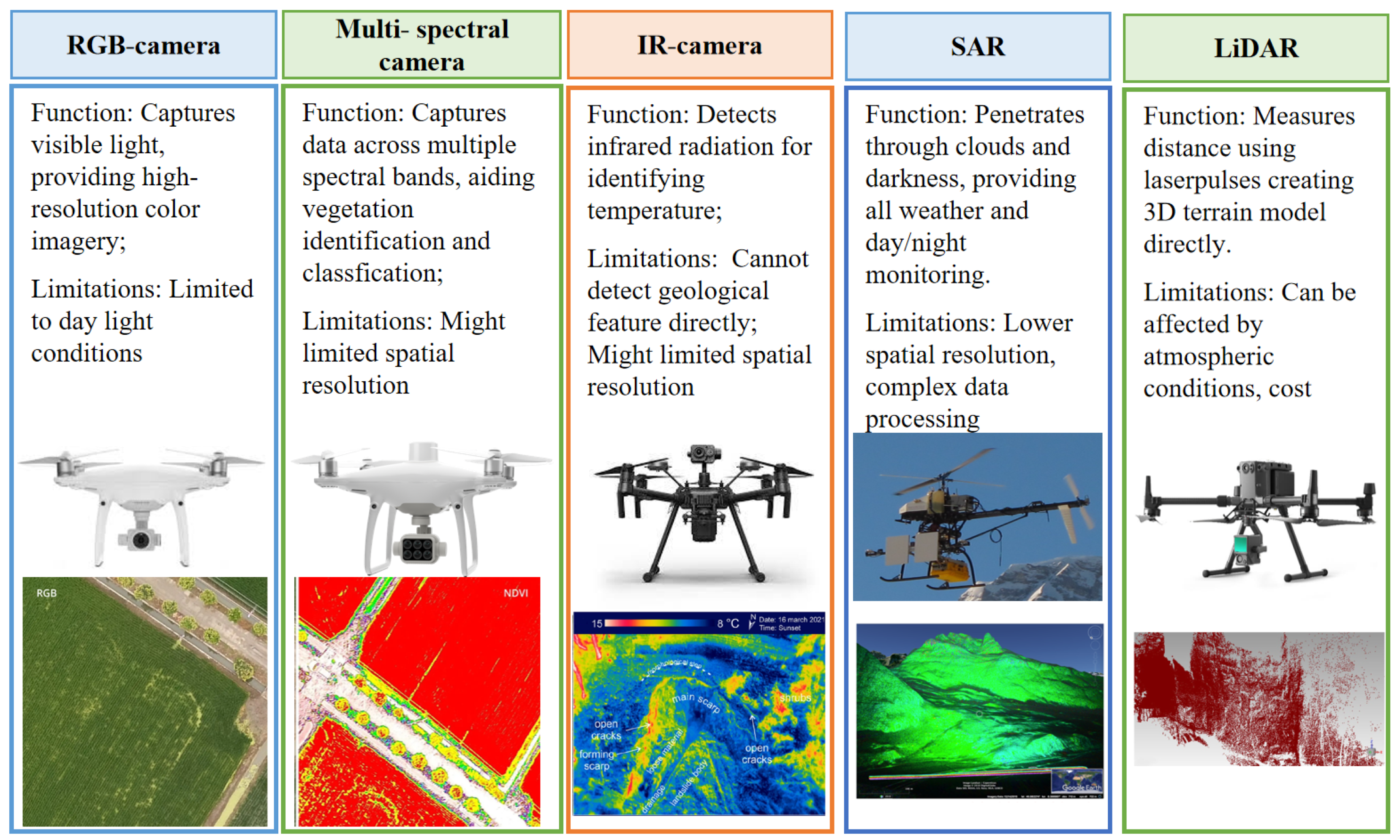
2.2.1. Optical Sensors
Visible Camera
Thermal Infrared Range (IR) Camera
Multi-Spectral Sensors Camera
2.2.2. Light Detection and Ranging (LiDAR)
2.2.3. Synthetic Aperture Radar (SAR)
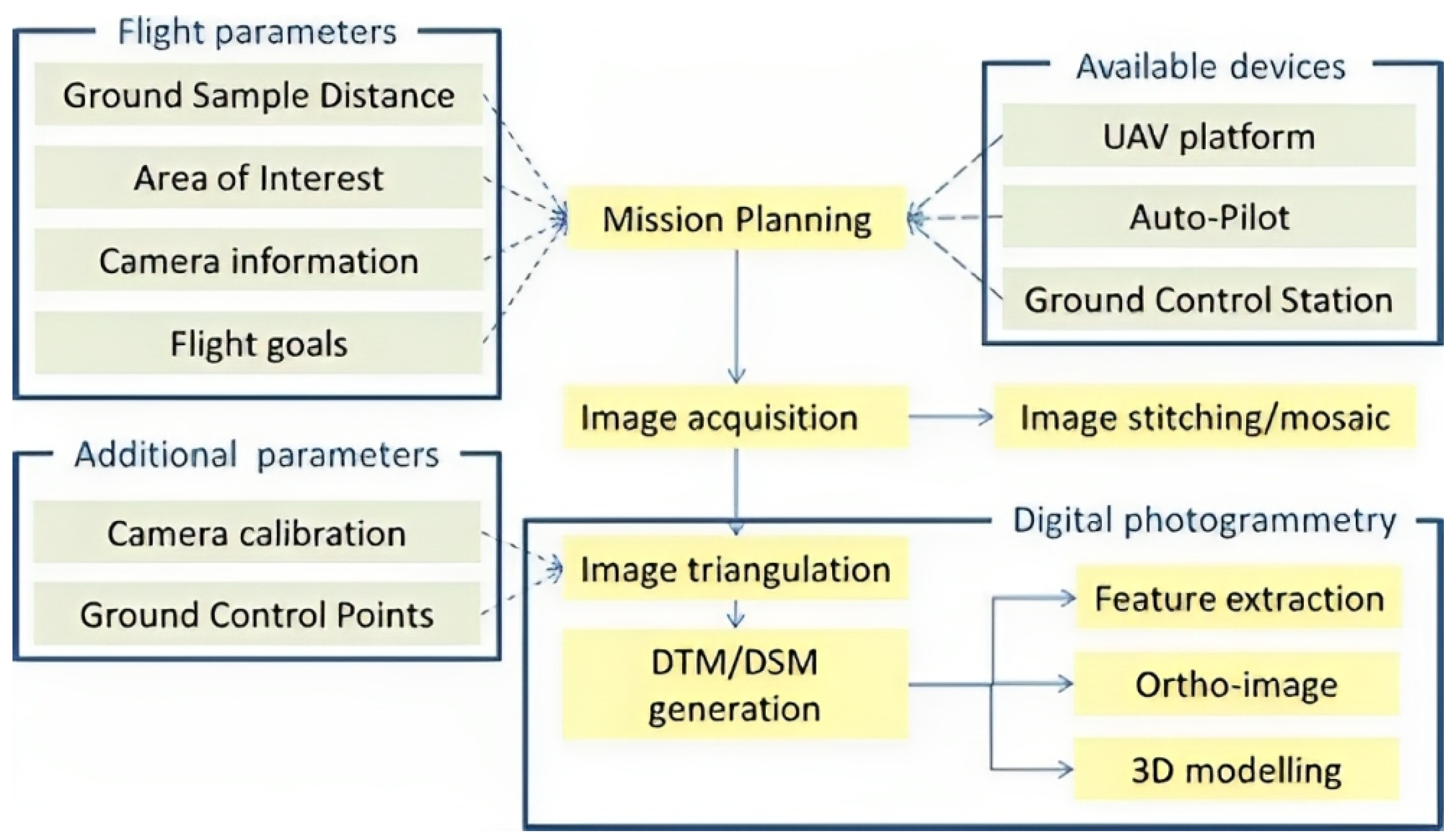
3. Integrated UAV Methodology for Landslide Analysis
3.1. UAV-Based Aerial Images
3.2. Model Reconstructions
3.2.1. UAV-Lidar-Based Reconstructions
3.2.2. UAV-Image-Based Reconstructions
3.3. Change Detection Based on Multi-Temporal 3D Models
4. Applications of UAVs in Landslide
4.1. Applications of UAVs in Landslide Geological Survey
4.1.1. Landslide Map** and Characterization
4.1.2. Landslide Model Reconstruction
4.1.3. Landslide Susceptibility Map**
4.2. UAV Applications for Landslide Monitoring
4.2.1. Surface Change Monitoring with UAV-Based Sensing
4.2.2. Crack and Fissure Change Monitoring Using UAV-Based Sensing
4.3. UAV Applications in Emergency Response
4.3.1. Emergency Response Strategies
4.3.2. Automated Detection and Machine Learning Algorithms Using UAV-Based Data
5. Challenges and Opportunities
6. Conclusions
Author Contributions
Funding
Conflicts of Interest
Abbreviations
| UAV | Unmanned Aerial Vehicle |
| GNSS | Global Navigation Satellite Systems |
| TLS | Terrestrial Laser Scanners |
| InSAR | Interferometric Synthetic Aperture Radar |
| IR | Infrared Range |
| LiDAR | Light Detection and Ranging |
| DOM | Digital Orthophoto Map |
| DEM | Digital Elevation Model |
| DSM | Digital Surface Model |
| DTM | Digital Terrain Model |
| SfM | Structure-from-Motion |
| GCP | Ground Control Point |
| M3C2 | Multiscale Model-to-Model Cloud Comparison |
| RTK | Real-time Kinematic |
| NDVI | Normalized Difference Vegetation Index |
| GIS | Geographic Information System |
Appendix A

| Reference | Scientific Issue, UAV Platform, Camera | Flight Parameter | GSD, Software, Accuracy |
|---|---|---|---|
| Chen et al. (2021) [54] | Landslide modeling; Multicopter-Feima D200; SONY RX1RII with 35.9 × 24 mm sensor | 55 m AGL, overlap/sidelap rate: 80%/65% | GSD 0.9 cm/pixel; Feima UAV manager; RMSxy < 1.7 cm, RMSz < 1.4 cm |
| Colica et al. (2021) [55] | Geological surveys; Multicopter-DJI Phantom 4 Pro; 1″ CMOS, 20-MP RGB camera | 30 m above the launch location, overlap/sidelap rate: >80%/>60% | GSD 0.87 cm/pixel; Agisoft Metashape; RMSE = 0.87 cm |
| Chang et al. (2020) [56] | Geological surveys; Fixed-wing-Skywalker X8; Nikon D800E | 1500–3000 m AGL, overlap/sidelap rate: >80%/>60% | GSD 15 cm/pixel; Pix4D Mapper; RMSE = 0.13–0.47 m |
| Hu et al. (2019) [106] | Landslide modeling; Multicopter-DJI Mavic Pro; 1/2.3″ CMOS, 12.35 MP camera | 149.7 m above the launch location, overlap/sidelap rate: 75%/75% | GSD 5 cm/pixel; unknown software; RMSE = 0.5 m |
| Rodriguez-Caballero et al. (2021) [154] | Landslide modeling; Multicopter-DJI Phantom 4; 1″ CMOS, 20-MP RGB camera | 60 m above the launch location, overlap/sidelap rate: 75%/65% | unknown GSD; Pix4Dmapper; RMSx = 0.096 m, RMSy = 0.14 m, RMSz = 0.33 m |
| Büschelberger et al. (2021) [155] | Landslide characterization; Multicopter-DJI Mavic Pro; 1/2.3″ CMOS, 12.35 MP camera | 110 m above the launch location, overlap/sidelap rate: 75%/65% | GSD < 5 cm/pixel; Agisoft Metashape; 1.4 pixels |
| Vassilakis et al. (2021) [67] | Landslide modeling; Multicopter-DJI Phantom 4; 1″ CMOS, 20-MP RGB camera | 120 m/140 m above the launch location, overlap/sidelap rate: 75%/65% | GSD unknown; Agisoft; <1 cm |
| Dille et al. (2020) [156] | Landslide modeling; Multicopter-DJI Phantom 3 Pro; 1/2.3 CMOS camera, 12 MP RGB camera | 115 m above the launch location, overlap/sidelap rate: 85%/75% | GSD 5 cm/pixel; Agisoft Photoscan; RMSx = 0.07 m, RMSy = 0.24 m |
| Koutalakis et al. (2021) [157] | Landslide modeling; Multicopter-DJI Mavic 2 Pro; 1″ CMOS, 20-MP RGB camera | 50 m above the launch location, overlap/sidelap rate: unknown | GSD unknown; Pix4Dmapper Pro; RMSE = 6 cm |
| Sandric et al. (2023) [158] | Landslide modeling; Multicopter-DJI Phantom 4; 1″ CMOS, 20-MP RGB camera | 114 m above the launch location, overlap/sidelap rate: 70%/70% | GSD unknown; ArcGIS Pro (ESRI); RMSx = 0.14–0.23 m, RMSy = 0.12–0.33 m, RMSz = 0.42–0.56 m |
| Xu et al. (2020) [159] | Landslide modeling; 1: Multicopter-MD4-1000; Sony ILCE-7R camera; 2: Fixed-wing-Feima F1000; | 1: 450 m above the launch location, overlap/sidelap rate: 60%/80%; 2: 270 m above the launch location, overlap/sidelap rate: 65%/80% | GSD 1 6 cm/pixel; GSD 2 4 cm/pixel; Pix4D Mapper, Polyworks; 1: RMSx 0.02–0.05 m, RMSy 0.03–0.04 m, RMSz 0.05–0.11 m; 2: RMSx 0.03–0.04 m, RMSy 0.02–0.04 m, RMSz 0.03–0.06 m; |
| Conforti et al. (2020) [160] | Landslide modeling; Multicopter-Parrot Anafi 21 Mp RGB camera | 131 m above the launch location, overlap/sidelap rate: 85%/80% | GSD 6.7 cm/pixel; Pix4D Mapper; RMSx = 0.19 m, RMSy = 0.18 m, RMSz = 0.21 m |
| Zarate et al. (2023) [161] | Landslide modeling; Multicopter-DJI Phantom 2; GoPro 3+ camera | 84.2–89 m above the launch location, overlap/sidelap rate: 70%/70% | GSD 4.0–4.3 cm/pixel; Agisoft PhotoScan; RMSE = 0.01–0.04 m |
References
- Floreano, D.; Wood, R.J. Science, technology and the future of small autonomous drones. Nature 2015, 521, 460–466. [Google Scholar] [CrossRef] [PubMed]
- Song, B.D.; Park, K.; Kim, J. Persistent UAV delivery logistics: MILP formulation and efficient heuristic. Comput. Ind. Eng. 2018, 120, 418–428. [Google Scholar] [CrossRef]
- Otto, A.; Agatz, N.; Campbell, J.; Golden, B.; Pesch, E. Optimization approaches for civil applications of unmanned aerial vehicles (UAVs) or aerial drones: A survey. Networks 2018, 72, 411–458. [Google Scholar] [CrossRef]
- Raj, R.; Kar, S.; Nandan, R.; Jagarlapudi, A. Precision agriculture and unmanned aerial Vehicles (UAVs). Unmanned Aerial Vehicle: Applications in Agriculture and Environment; Springer: Berlin/Heidelberg, Germany, 2020; pp. 7–23. [Google Scholar] [CrossRef]
- Manfreda, S.; McCabe, M.F.; Miller, P.E.; Lucas, R.; Pajuelo Madrigal, V.; Mallinis, G.; Ben Dor, E.; Helman, D.; Estes, L.; Ciraolo, G.; et al. On the use of unmanned aerial systems for environmental monitoring. Remote Sens. 2018, 10, 641. [Google Scholar] [CrossRef]
- Elghaish, F.; Matarneh, S.; Talebi, S.; Kagioglou, M.; Hosseini, M.R.; Abrishami, S. Toward digitalization in the construction industry with immersive and drones technologies: A critical literature review. Smart Sustain. Built Environ. 2021, 10, 345–363. [Google Scholar] [CrossRef]
- Garnica-Peña, R.J.; Alcántara-Ayala, I. The use of UAVs for landslide disaster risk research and disaster risk management: A literature review. J. Mt. Sci. 2021, 18, 482–498. [Google Scholar] [CrossRef]
- Gomez, C.; Purdie, H. UAV-based photogrammetry and geocomputing for hazards and disaster risk monitoring—A review. Geoenviron. Disasters 2016, 3, 23. [Google Scholar] [CrossRef]
- Cruden, D. A simple definition of a landslide. Bull. Eng. Geol. Environ. 1991, 43, 27. [Google Scholar] [CrossRef]
- Dai, F.C.; Lee, C.F.; Ngai, Y.Y. Landslide risk assessment and management: An overview. Eng. Geol. 2002, 64, 65–87. [Google Scholar] [CrossRef]
- Maturidi, A.M.A.M.; Kasim, N.; Taib, K.A.; Azahar, W.N.A.W. Rainfall-induced landslide thresholds development by considering different rainfall parameters: A Review. J. Ecol. Eng. 2021, 22, 85–97. [Google Scholar] [CrossRef]
- Tohari, A. Study of rainfall-induced landslide: A review. In Proceedings of the IOP Conference Series: Earth and Environmental Science; IOP Publishing: Bristol, UK, 2018; Volume 118, p. 012036. [Google Scholar]
- Lee, M.L.; Ng, K.Y.; Huang, Y.F.; Li, W.C. Rainfall-induced landslides in Hulu Kelang area, Malaysia. Nat. Hazards 2014, 70, 353–375. [Google Scholar] [CrossRef]
- Huang, F.; Chen, J.; Liu, W.; Huang, J.; Hong, H.; Chen, W. Regional rainfall-induced landslide hazard warning based on landslide susceptibility map** and a critical rainfall threshold. Geomorphology 2022, 408, 108236. [Google Scholar] [CrossRef]
- Song, K.; Wang, F.; Yi, Q.; Lu, S. Landslide deformation behavior influenced by water level fluctuations of the Three Gorges Reservoir (China). Eng. Geol. 2018, 247, 58–68. [Google Scholar] [CrossRef]
- Zhao, S.; Zeng, R.; Zhang, H.; Meng, X.; Zhang, Z.; Meng, X.; Wang, H.; Zhang, Y.; Liu, J. Impact of water level fluctuations on landslide deformation at Longyangxia reservoir, Qinghai province, China. Remote Sens. 2022, 14, 212. [Google Scholar] [CrossRef]
- Zhang, Y.; Zhu, S.; Tan, J.; Li, L.; Yin, X. The influence of water level fluctuation on the stability of landslide in the Three Gorges Reservoir. Arab. J. Geosci. 2020, 13, 845. [Google Scholar] [CrossRef]
- He, C.c.; Hu, X.l.; Xu, C.; Wu, S.s.; Zhang, H.; Liu, C. Model test of the influence of cyclic water level fluctuations on a landslide. J. Mt. Sci. 2020, 17, 191–202. [Google Scholar] [CrossRef]
- Larsen, I.J.; Montgomery, D.R. Landslide erosion coupled to tectonics and river incision. Nat. Geosci. 2012, 5, 468–473. [Google Scholar] [CrossRef]
- Cebulski, J. Impact of river erosion on variances in colluvial movement and type for landslides in the Polish Outer Carpathians. Catena 2022, 217, 106415. [Google Scholar] [CrossRef]
- Premchitt, J.; Brand, E.; Phillipson, H. Landslides caused by rapid groundwater changes. Geol. Soc. London Eng. Geol. Spec. Publ. 1986, 3, 87–94. [Google Scholar] [CrossRef]
- Corominas, J.; Moya, J.; Ledesma, A.; Lloret, A.; Gili, J.A. Prediction of ground displacements and velocities from groundwater level changes at the Vallcebre landslide (Eastern Pyrenees, Spain). Landslides 2005, 2, 83–96. [Google Scholar] [CrossRef]
- Yin, Y.; Wang, F.; Sun, P. Landslide hazards triggered by the 2008 Wenchuan earthquake, Sichuan, China. Landslides 2009, 6, 139–152. [Google Scholar] [CrossRef]
- Keefer, D.K. Investigating landslides caused by earthquakes—A historical review. Surv. Geophys. 2002, 23, 473–510. [Google Scholar] [CrossRef]
- Shao, X.; Xu, C. Earthquake-induced landslides susceptibility assessment: A review of the state-of-the-art. Nat. Hazards Res. 2022, 2, 172–182. [Google Scholar] [CrossRef]
- Huang, R.; Fan, X. The landslide story. Nat. Geosci. 2013, 6, 325–326. [Google Scholar] [CrossRef]
- Korup, O.; Seidemann, J.; Mohr, C.H. Increased landslide activity on forested hillslopes following two recent volcanic eruptions in Chile. Nat. Geosci. 2019, 12, 284–289. [Google Scholar] [CrossRef]
- Froude, M.J.; Petley, D.N. Global fatal landslide occurrence from 2004 to 2016. Nat. Hazards Earth Syst. Sci. 2018, 18, 2161–2181. [Google Scholar] [CrossRef]
- Hussain, Y.; Schlögel, R.; Innocenti, A.; Hamza, O.; Iannucci, R.; Martino, S.; Havenith, H.B. Review on the Geophysical and UAV-Based Methods Applied to Landslides. Remote Sens. 2022, 14, 4564. [Google Scholar] [CrossRef]
- Kang, Y.; Zhao, C.; Zhang, Q.; Lu, Z.; Li, B. Application of InSAR techniques to an analysis of the Guanling landslide. Remote Sens. 2017, 9, 1046. [Google Scholar] [CrossRef]
- Sun, Q.; Zhang, L.; Ding, X.; Hu, J.; Li, Z.; Zhu, J. Slope deformation prior to Zhouqu, China landslide from InSAR time series analysis. Remote Sens. Environ. 2015, 156, 45–57. [Google Scholar] [CrossRef]
- Van Natijne, A.; Bogaard, T.; van Leijen, F.; Hanssen, R.; Lindenbergh, R. World-wide InSAR sensitivity index for landslide deformation tracking. Int. J. Appl. Earth Obs. Geoinf. 2022, 111, 102829. [Google Scholar] [CrossRef]
- Rosi, A.; Tofani, V.; Tanteri, L.; Tacconi Stefanelli, C.; Agostini, A.; Catani, F.; Casagli, N. The new landslide inventory of Tuscany (Italy) updated with PS-InSAR: Geomorphological features and landslide distribution. Landslides 2018, 15, 5–19. [Google Scholar] [CrossRef]
- Xu, Q.; Zhao, B.; Dai, K.; Dong, X.; Li, W.; Zhu, X.; Yang, Y.; ** of shallow landslides with object-based image analysis from unmanned aerial vehicle data. Eng. Geol. 2019, 260, 105264. [Google Scholar] [CrossRef]
- Nex, F.; Remondino, F. UAV for 3D map** applications: A review. Appl. Geomat. 2014, 6, 1–15. [Google Scholar] [CrossRef]
- Johnson, S.E.; Haneberg, W.C.; Bryson, L.S.; Crawford, M.M. Measuring ground surface elevation changes in a slow-moving colluvial landslide using combinations of regional airborne lidar, UAV lidar and UAV photogrammetric surveys. Q. J. Eng. Geol. Hydrogeol. 2023, 56, qjegh2022–078. [Google Scholar] [CrossRef]
- Li, W.; Zhao, B.; Xu, Q.; Yang, F.; Fu, H.; Dai, C.; Wu, X. Deformation characteristics and failure mechanism of a reactivated landslide in Leidashi, Sichuan, China, on 6 August 2019: An emergency investigation report. Landslides 2020, 17, 1405–1413. [Google Scholar] [CrossRef]
- Zhou, C.; Ai, D.; Huang, W.; Xu, H.; Ma, L.; Chen, L.; Wang, L. Emergency Survey and Stability Analysis of a Rainfall-Induced Soil-Rock Mixture Landslide at Chongqing City, China. Front. Earth Sci. 2021, 9, 774200. [Google Scholar] [CrossRef]
- Zheng, X.; Yang, X.; Ma, H.; Ren, G.; Yu, Z.; Yang, F.; Zhang, H.; Gao, W. Integrative Landslide Emergency Monitoring Scheme Based on GB-INSAR Interferometry, Terrestrial Laser Scanning and UAV Photography. J. Phys. Conf. Ser. 2019, 1213, 052069. [Google Scholar] [CrossRef]
- Corominas, J.; van Westen, C.; Frattini, P.; Cascini, L.; Malet, J.P.; Fotopoulou, S.; Catani, F.; Van Den Eeckhaut, M.; Mavrouli, O.; Agliardi, F.; et al. Recommendations for the quantitative analysis of landslide risk. Bull. Eng. Geol. Environ. 2014, 73, 209–263. [Google Scholar] [CrossRef]
- Qi, J.; Chen, H.; Chen, F. Extraction of landslide features in UAV remote sensing images based on machine vision and image enhancement technology. Neural Comput. Appl. 2022, 34, 12283–12297. [Google Scholar] [CrossRef]
- Lucieer, A.; Jong, S.M.D.; Turner, D. Map** landslide displacements using Structure from Motion (SfM) and image correlation of multi-temporal UAV photography. Prog. Phys. Geogr. Earth Environ. 2014, 38, 97–116. [Google Scholar] [CrossRef]
- Saito, H.; Uchiyama, S.; Hayakawa, Y.S.; Obanawa, H. Landslides triggered by an earthquake and heavy rainfalls at Aso volcano, Japan, detected by UAS and SfM-MVS photogrammetry. Prog. Earth Planet. Sci. 2018, 5, 15. [Google Scholar] [CrossRef]
- Saeed, A.; Younes, A.; Cai, C.; Cai, G. A Survey of Hybrid Unmanned Aerial Vehicles. Prog. Aerosp. Sci. 2018, 98, 91–105. [Google Scholar] [CrossRef]
- Gantimurova, S.; Parshin, A.; Erofeev, V. GIS-based landslide susceptibility map** of the Circum-Baikal railway in Russia using UAV data. Remote Sens. 2021, 13, 3629. [Google Scholar] [CrossRef]
- Zhang, H.; Zhang, D.x. A combined survey to evaluate the thermal behavior of loess for a landslide-prone slope on the Heifangtai terrace in Northwest China. J. Mt. Sci. 2021, 18, 620. [Google Scholar] [CrossRef]
- Melis, M.T.; Da Pelo, S.; Erbì, I.; Loche, M.; Deiana, G.; Demurtas, V.; Meloni, M.A.; Dessì, F.; Funedda, A.; Scaioni, M.; et al. Thermal remote sensing from UAVs: A review on methods in coastal cliffs prone to landslides. Remote Sens. 2020, 12, 1971. [Google Scholar] [CrossRef]
- Delbridge, B.G.; Bürgmann, R.; Fielding, E.; Hensley, S.; Schulz, W.H. Three-dimensional surface deformation derived from airborne interferometric UAVSAR: Application to the Slumgullion Landslide. J. Geophys. Res. Solid Earth 2016, 121, 3951–3977. [Google Scholar] [CrossRef]
- Bekar, A.; Antoniou, M.; Baker, C.J. Low-Cost, High-Resolution, Drone-Borne SAR Imaging. IEEE Trans. Geosci. Remote Sens. 2021, 60, 5208811. [Google Scholar] [CrossRef]
- Moreira, L.; Lubeck, D.; Wimmer, C.; Castro, F.; Goes, J.A.; Castro, V.; Alcantara, M.; Ore, G.; Oliveira, L.P.; Bins, L.; et al. Drone-Borne P-band Single-Pass InSAR. In Proceedings of the 2020 IEEE Radar Conference (RadarConf20), Florence, Italy, 21–25 September 2020; pp. 1–6. [Google Scholar] [CrossRef]
- Liu, C.; Liu, X.; Peng, X.; Wang, E.; Wang, S. Application of 3D-DDA integrated with unmanned aerial vehicle–laser scanner (UAV-LS) photogrammetry for stability analysis of a blocky rock mass slope. Landslides 2019, 16, 1645–1661. [Google Scholar] [CrossRef]
- Cheng, Z.; Gong, W.; Tang, H.; Juang, C.H.; Deng, Q.; Chen, J.; Ye, X. UAV photogrammetry-based remote sensing and preliminary assessment of the behavior of a landslide in Guizhou, China. Eng. Geol. 2021, 289, 106172. [Google Scholar] [CrossRef]
- Colica, E.; D’Amico, S.; Iannucci, R.; Martino, S.; Gauci, A.; Galone, L.; Galea, P.; Paciello, A. Using unmanned aerial vehicle photogrammetry for digital geological surveys: Case study of Selmun promontory, northern of Malta. Environ. Earth Sci. 2021, 80, 551. [Google Scholar] [CrossRef]
- Chang, K.J.; Tseng, C.W.; Tseng, C.M.; Liao, T.C.; Yang, C.J. Application of Unmanned Aerial Vehicle (UAV)-Acquired Topography for Quantifying Typhoon-Driven Landslide Volume and Its Potential Topographic Impact on Rivers in Mountainous Catchments. Appl. Sci. 2020, 10, 6102. [Google Scholar] [CrossRef]
- Frodella, W.; Gigli, G.; Morelli, S.; Lombardi, L.; Casagli, N. Landslide map** and characterization through infrared thermography (IRT): Suggestions for a methodological approach from some case studies. Remote Sens. 2017, 9, 1281. [Google Scholar] [CrossRef]
- Liu, D.; Hu, X.; Zhou, C.; Li, L.; He, C.; Sun, T. Model test study of a landslide stabilized with piles and evolutionary stage identification based on thermal infrared temperature analysis. Landslides 2020, 17, 1393–1404. [Google Scholar] [CrossRef]
- Godone, D.; Allasia, P.; Borrelli, L.; Gullà, G. UAV and Structure from Motion Approach to Monitor the Maierato Landslide Evolution. Remote Sens. 2020, 12, 1039. [Google Scholar] [CrossRef]
- Colomina, I.; Molina, P. Unmanned aerial systems for photogrammetry and remote sensing: A review. ISPRS J. Photogramm. Remote Sens. 2014, 92, 79–97. [Google Scholar] [CrossRef]
- Robles-Kelly, A.; Huynh, C.P. Imaging Spectroscopy for Scene Analysis; Springer Science & Business Media: Berlin/Heidelberg, Germany, 2012. [Google Scholar]
- Adam, E.; Mutanga, O.; Rugege, D. Multispectral and hyperspectral remote sensing for identification and map** of wetland vegetation: A review. Wetl. Ecol. Manag. 2010, 18, 281–296. [Google Scholar] [CrossRef]
- DJIEnterprise. DJI P4 Multispectral Specs. 2023. Available online: https://www.dji.com/p4-multispectral/specs (accessed on 15 January 2024).
- Jaboyedoff, M.; Derron, M.H. Landslide analysis using laser scanners. In Developments in Earth Surface Processes; Elsevier: Amsterdam, The Netherlands, 2020; Volume 23, pp. 207–230. [Google Scholar] [CrossRef]
- Vargas Rivero, J.R.; Gerbich, T.; Buschardt, B.; Chen, J. Data augmentation of automotive lidar point clouds under adverse weather situations. Sensors 2021, 21, 4503. [Google Scholar] [CrossRef]
- Chen, S.; Wang, H.; Xu, F.; **, Y.Q. Target classification using the deep convolutional networks for SAR images. IEEE Trans. Geosci. Remote Sens. 2016, 54, 4806–4817. [Google Scholar] [CrossRef]
- Vassilakis, E.; Foumelis, M.; Erkeki, A.; Kotsi, E.; Lekkas, E. Post-event surface deformation of Amyntaio slide (Greece) by complementary analysis of Remotely Piloted Airborne System imagery and SAR interferometry. Appl. Geomat. 2021, 13, 65–75. [Google Scholar] [CrossRef]
- Zimmermann, F.; Eling, C.; Klingbeil, L.; Kuhlmann, H. Precise positioning of uavs–dealing with challenging rtk-gps measurement conditions during automated uav flights. ISPRS Ann. Photogramm. Remote. Sens. Spat. Inf. Sci. 2017, 4, 95–102. [Google Scholar] [CrossRef]
- Zhou, H.; ** accuracy based on variation of ground control points. Int. J. Appl. Earth Obs. Geoinf. 2018, 72, 1–10. [Google Scholar] [CrossRef]
- Ludwig, M.M.; Runge, C.; Friess, N.; Koch, T.L.; Richter, S.; Seyfried, S.; Wraase, L.; Lobo, A.; Sebastià, M.T.; Reudenbach, C.; et al. Quality assessment of photogrammetric methods—A workflow for reproducible UAS orthomosaics. Remote Sens. 2020, 12, 3831. [Google Scholar] [CrossRef]
- Szypuła, B. Accuracy of UAV-based DEMs without ground control points. GeoInformatica 2023, 28, 1–28. [Google Scholar] [CrossRef]
- Ouédraogo, M.M.; Degré, A.; Debouche, C.; Lisein, J. The evaluation of unmanned aerial system-based photogrammetry and terrestrial laser scanning to generate DEMs of agricultural watersheds. Geomorphology 2014, 214, 339–355. [Google Scholar] [CrossRef]
- Sona, G.; Pinto, L.; Pagliari, D.; Passoni, D.; Gini, R. Experimental analysis of different software packages for orientation and digital surface modelling from UAV images. Earth Sci. Inform. 2014, 7, 97–107. [Google Scholar] [CrossRef]
- James, M.R.; Robson, S. Straightforward reconstruction of 3D surfaces and topography with a camera: Accuracy and geoscience application. J. Geophys. Res. Earth Surf. 2012, 117. [Google Scholar] [CrossRef]
- Carrivick, J.L.; Smith, M.W.; Quincey, D.J. Structure from Motion in the Geosciences; John Wiley & Sons: Hoboken, NJ, USA, 2016. [Google Scholar]
- Peppa, M.V.; Mills, J.P.; Moore, P.; Miller, P.E.; Chambers, J.E. Accuracy Assessment of a UAV-BASED Landslide Monitoring System. ISPRS Int. Arch. Photogramm. Remote Sens. Spat. Inf. Sci. 2016, XLI-B5, 895–902. [Google Scholar] [CrossRef]
- Fernández, T.; Pérez, J.; Cardenal, J.; Gómez, J.; Colomo, C.; Delgado, J. Analysis of Landslide Evolution Affecting Olive Groves Using UAV and Photogrammetric Techniques. Remote Sens. 2016, 8, 837. [Google Scholar] [CrossRef]
- Ma, S.; Xu, C.; Shao, X.; Zhang, P.; Liang, X.; Tian, Y. Geometric and kinematic features of a landslide in Mabian Sichuan, China, derived from UAV photography. Landslides 2019, 16, 373–381. [Google Scholar] [CrossRef]
- Bentley, M.J.; Foster, J.M.; Potvin, J.J.; Bevan, G.; Sharp, J.; Woeller, D.J.; Take, W.A. Surface displacement expression of progressive failure in a sensitive clay landslide observed with long-term UAV monitoring. Landslides 2023, 20, 531–546. [Google Scholar] [CrossRef]
- Wheaton, J.M. Uncertainity in Morphological Sediment Budgeting of Rivers. Ph.D. Thesis, University of Southampton, Southampton, UK, 2008. [Google Scholar]
- Girardeau-Montaut, D.; Roux, M.; Marc, R.; Thibault, G. Change detection on points cloud data acquired with a ground laser scanner. Int. Arch. Photogramm. Remote Sens. Spat. Inf. Sci. 2005, 36, W19. [Google Scholar]
- Cignoni, P.; Rocchini, C.; Scopigno, R. Metro: Measuring error on simplified surfaces. In Computer Graphics Forum; Wiley Online Library: Oxford, UK, 1998; Volume 17, pp. 167–174. [Google Scholar] [CrossRef]
- Lague, D.; Brodu, N.; Leroux, J. Accurate 3D comparison of complex topography with terrestrial laser scanner: Application to the Rangitikei canyon (NZ). ISPRS J. Photogramm. Remote Sens. 2013, 82, 10–26. [Google Scholar] [CrossRef]
- Gojcic, Z.; Zhou, C.; Wieser, A. F2S3: Robustified determination of 3D displacement vector fields using deep learning. J. Appl. Geod. 2020, 14, 177–189. [Google Scholar] [CrossRef]
- Gojcic, Z.; Schmid, L.; Wieser, A. Dense 3D displacement vector fields for point cloud-based landslide monitoring. Landslides 2021, 18, 3821–3832. [Google Scholar] [CrossRef]
- Andresen, C.G.; Schultz-Fellenz, E.S. Change Detection Applications in the Earth Sciences Using UAS-Based Sensing: A Review and Future Opportunities. Drones 2023, 7, 258. [Google Scholar] [CrossRef]
- Al-Rawabdeh, A.; He, F.; Moussa, A.; El-Sheimy, N.; Habib, A. Using an unmanned aerial vehicle-based digital imaging system to derive a 3D point cloud for landslide scarp recognition. Remote Sens. 2016, 8, 95. [Google Scholar] [CrossRef]
- Peng, D.; Xu, Q.; Liu, F.; He, Y.; Zhang, S.; Qi, X.; Zhao, K.; Zhang, X. Distribution and failure modes of the landslides in Heitai terrace, China. Eng. Geol. 2018, 236, 97–110. [Google Scholar] [CrossRef]
- Qiu, H.; Cui, P.; Regmi, A.D.; Hu, S.; Wang, X.; Zhang, Y. The effects of slope length and slope gradient on the size distributions of loess slides: Field observations and simulations. Geomorphology 2018, 300, 69–76. [Google Scholar] [CrossRef]
- Hu, S.; Qiu, H.; Pei, Y.; Cui, Y.; ** by using GIS along the China–Pakistan economic corridor (Karakoram Highway), Pakistan. Nat. Hazards Earth Syst. Sci 2018, 11, 131–148. [Google Scholar]
- Meten, M.; PrakashBhandary, N.; Yatabe, R. Effect of landslide factor combinations on the prediction accuracy of landslide susceptibility maps in the Blue Nile Gorge of Central Ethiopia. Geoenviron. Disasters 2015, 2, 9. [Google Scholar] [CrossRef]
- Vojteková, J.; Vojtek, M. Assessment of landslide susceptibility at a local spatial scale applying the multi-criteria analysis and GIS: A case study from Slovakia. Geomat. Nat. Hazards Risk 2020, 11, 131–148. [Google Scholar] [CrossRef]
- Kakavas, M.P.; Nikolakopoulos, K.G. Digital elevation models of rockfalls and landslides: A review and meta-analysis. Geosciences 2021, 11, 256. [Google Scholar] [CrossRef]
- Tempa, K.; Peljor, K.; Wangdi, S.; Ghalley, R.; Jamtsho, K.; Ghalley, S.; Pradhan, P. UAV technique to localize landslide susceptibility and mitigation proposal: A case of Rinchending Goenpa landslide in Bhutan. Nat. Hazards Res. 2021, 1, 171–186. [Google Scholar] [CrossRef]
- Bhatt, B.P.; Awasthi, K.D.; Heyojoo, B.P.; Silwal, T.; Kafle, G. Using geographic information system and analytical hierarchy process in landslide hazard zonation. Appl. Ecol. Environ. Sci. 2013, 1, 14–22. [Google Scholar] [CrossRef]
- Song, Y.; Gong, J.; Gao, S.; Wang, D.; Cui, T.; Li, Y.; Wei, B. Susceptibility assessment of earthquake-induced landslides using Bayesian network: A case study in Beichuan, China. Comput. Geosci. 2012, 42, 189–199. [Google Scholar] [CrossRef]
- Chae, B.G.; Park, H.J.; Catani, F.; Simoni, A.; Berti, M. Landslide prediction, monitoring and early warning: A concise review of state-of-the-art. Geosci. J. 2017, 21, 1033–1070. [Google Scholar] [CrossRef]
- Ma, S.; Wei, J.; Xu, C.; Shao, X.; Xu, S.; Chai, S.; Cui, Y. UAV survey and numerical modeling of loess landslides: An example from Zaoling, southern Shanxi Province, China. Nat. Hazards 2020, 104, 1125–1140. [Google Scholar] [CrossRef]
- Huang, A.B.; Lee, J.T.; Ho, Y.T.; Chiu, Y.F.; Cheng, S.Y. Stability monitoring of rainfall-induced deep landslides through pore pressure profile measurements. Soils Found. 2012, 52, 737–747. [Google Scholar] [CrossRef]
- Toll, D.; Lourenço, S.; Mendes, J.; Gallipoli, D.; Evans, F.; Augarde, C.; Cui, Y.J.; Tang, A.; Rojas, J.; Pagano, L.; et al. Soil Suction Monitoring for Landslides and Slopes; Geological Society of London: London, UK, 2011. [Google Scholar] [CrossRef]
- Sestras, P.; Bilasco, S.; Rosca, S.; Dudic, B.; Hysa, A.; Spalevic, V. Geodetic and UAV monitoring in the sustainable management of shalloSw landslides and erosion of a susceptible urban environment. Remote Sens. 2021, 13, 385. [Google Scholar] [CrossRef]
- Mazzanti, P.; Caporossi, P.; Brunetti, A.; Mohammadi, F.I.; Bozzano, F. Short-term geomorphological evolution of the Poggio Baldi landslide upper scarp via 3D change detection. Landslides 2021, 18, 2367–2381. [Google Scholar] [CrossRef]
- Cai, J.; Wang, C.; Zhang, L. Analysis of Mass Wasting Processes in the Slumgullion Landslide Using Multi-Track Time-Series UAVSAR Images. Remote Sens. 2023, 15, 4746. [Google Scholar] [CrossRef]
- Hu, X.; Bürgmann, R.; Fielding, E.J.; Lee, H. Internal kinematics of the Slumgullion landslide (USA) from high-resolution UAVSAR InSAR data. Remote Sens. Environ. 2020, 251, 112057. [Google Scholar] [CrossRef]
- Molan, Y.E.; Lohman, R.B. A Pattern-Based Strategy for InSAR Phase Unwrap** and Application to Two Landslides in Colorado. J. Geophys. Res. Solid Earth 2023, 128, e2022JB025761. [Google Scholar] [CrossRef]
- Chowdhury, R.; Zhang, S. Tension cracks and slope failure. In Slope Stability Engineering Developments and Applications: Proceedings of the International Conference on Slope Stability Organized by the Institution of Civil Engineers and Held on the Isle of Wight on 15–18 April 1991; Thomas Telford Publishing: London, UK, 1991; pp. 27–32. [Google Scholar] [CrossRef]
- Khattak, G.A.; Owen, L.A.; Kamp, U.; Harp, E.L. Evolution of earthquake-triggered landslides in the Kashmir Himalaya, northern Pakistan. Geomorphology 2010, 115, 102–108. [Google Scholar] [CrossRef]
- Stumpf, A.; Malet, J.P.; Kerle, N.; Niethammer, U.; Rothmund, S. Image-based map** of surface fissures for the investigation of landslide dynamics. Geomorphology 2013, 186, 12–27. [Google Scholar] [CrossRef]
- Xu, L.; Dai, F.; Tham, L.; Zhou, Y.; Wu, C. Investigating landslide-related cracks along the edge of two loess platforms in northwest China. Earth Surf. Process. Landf. 2012, 37, 1023–1033. [Google Scholar] [CrossRef]
- Tang, H.; Wasowski, J.; Juang, C.H. Geohazards in the three Gorges Reservoir Area, China–Lessons learned from decades of research. Eng. Geol. 2019, 261, 105267. [Google Scholar] [CrossRef]
- Wang, H.; Nie, D.; Tuo, X.; Zhong, Y. Research on crack monitoring at the trailing edge of landslides based on image processing. Landslides 2020, 17, 985–1007. [Google Scholar] [CrossRef]
- Vivaldi, V.; Bordoni, M.; Mineo, S.; Crozi, M.; Pappalardo, G.; Meisina, C. Airborne combined photogrammetry—Infrared thermography applied to landslide remote monitoring. Landslides 2023, 20, 297–313. [Google Scholar] [CrossRef]
- Baroň, I.; Bečkovskỳ, D.; Míča, L. Application of infrared thermography for map** open fractures in deep-seated rockslides and unstable cliffs. Landslides 2014, 11, 15–27. [Google Scholar] [CrossRef]
- Iwaszenko, S.; Kalisz, P.; Słota, M.; Rudzki, A. Detection of natural gas leakages using a laser-based methane sensor and uav. Remote Sens. 2021, 13, 510. [Google Scholar] [CrossRef]
- Gómez, C.; Green, D.R. Small unmanned airborne systems to support oil and gas pipeline monitoring and map**. Arab. J. Geosci. 2017, 10, 202. [Google Scholar] [CrossRef]
- Marinos, V.; Stoumpos, G.; Papazachos, C. Landslide hazard and risk assessment for a natural gas pipeline project: The case of the Trans Adriatic Pipeline, Albania Section. Geosciences 2019, 9, 61. [Google Scholar] [CrossRef]
- Nyman, D.J.; Lee, E.M.; Audibert, J.M. Mitigating geohazards for international pipeline projects: Challenges and lessons learned. In Proceedings of the 2008 7th International Pipeline Conference, Calgary, AB, Canada, 29 September–3 October 2008; Volume 48593, pp. 639–648. [Google Scholar] [CrossRef]
- DJIEnterprise. DJI Records More Than 1000 People Rescued by Drones Globally. 2023. Available online: https://www.dji.com/newsroom/news/dji-records-more-than-1000-people-rescued-by-drones-globally (accessed on 15 January 2024).
- Zhou, J.w.; Jiang, N.; Li, H.b. Automatic discontinuity identification and quantitative monitoring of unstable blocks using terrestrial laser scanning in large landslide during emergency disposal. Landslides 2023. [Google Scholar] [CrossRef]
- He, K.; Liu, B.; Hu, X. Preliminary reports of a catastrophic landslide occurred on August 21, 2020, in Hanyuan County, Sichuan Province, China. Landslides 2021, 18, 503–507. [Google Scholar] [CrossRef]
- Guo, F.Y.; Meng, X.M.; Qi, T.J.; Dijkstra, T.; Thorkildsen, J.K.; Yue, D.X.; Chen, G.; Zhang, Y.; Dou, X.D.; Shi, P.Q. Rapid onset hazards, fault-controlled landslides and multi-method emergency decision-making. J. Mt. Sci. 2022, 19, 1357–1369. [Google Scholar] [CrossRef]
- Jiang, N.; Li, C.j.; Li, H.b.; Zhou, Z.d.; Lu, G.d.; Zhou, J.w. Preliminary analysis of a landslide-dammed lake induced by two consecutive earthquakes on June 1, 2022, Sichuan Province, China. Landslides 2022, 19, 2535–2538. [Google Scholar] [CrossRef]
- Liu, B.; He, K.; Han, M.; Hu, X.; Ma, G.; Wu, M. Application of UAV and GB-SAR in Mechanism Research and Monitoring of Zhonghaicun Landslide in Southwest China. Remote Sens. 2021, 13, 1653. [Google Scholar] [CrossRef]
- Zhao, B.; Zhang, H.; Hongjian, L.; Li, W.; Su, L.; He, W.; Zeng, L.; Qin, H.; Dhital, M.R. Emergency response to the reactivated Aniangzhai landslide resulting from a rainstorm-triggered debris flow, Sichuan Province, China. Landslides 2021, 18, 1115–1130. [Google Scholar] [CrossRef]
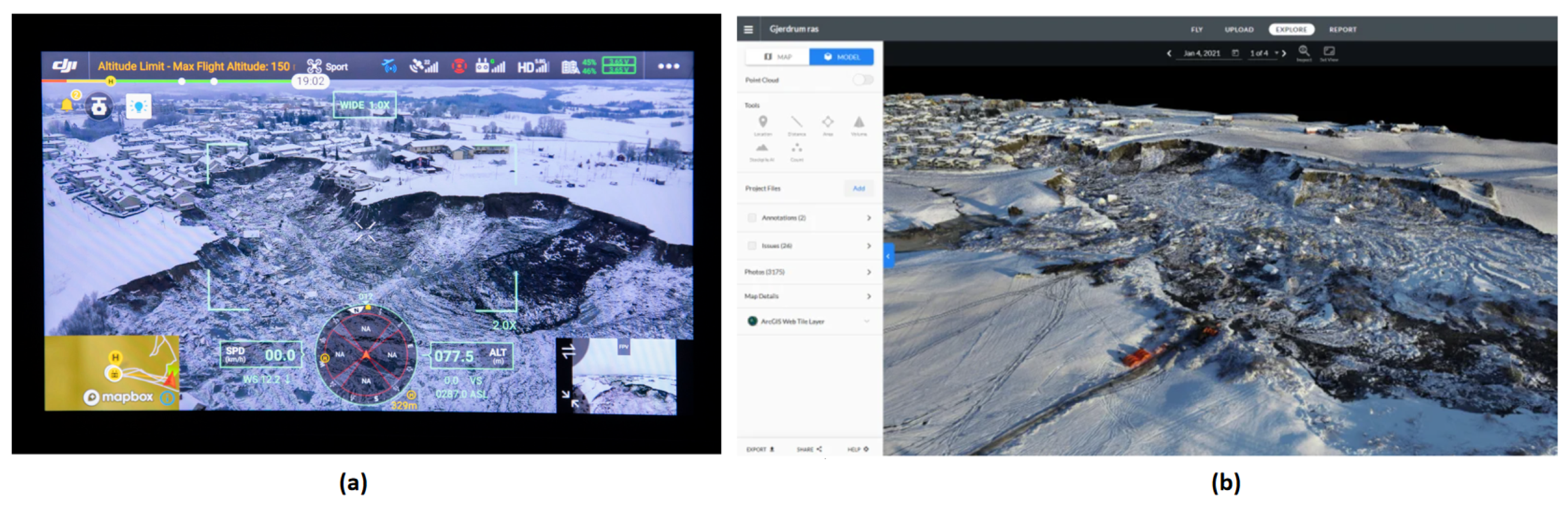
- DUKOWITZ, Z. Landslide in Norway Leads to Largest European Drone Operation Ever, 200+ Hours of Flight Time Recorded. 2021. Available online: https://uavcoach.com/ask-landslide-drone-operation/ (accessed on 15 January 2024).
- Enterprise, D. Drones Were Critical for Search and Rescue during Norway’s Biggest Landslide Disaster. 2021. Available online: https://enterprise-insights.dji.com/blog/let-drones-search-so-you-can-rescue-norway-landslide-m300 (accessed on 15 January 2024).
- PIX4Dmapper. Drone Map** Saves Lives in Landslides. 2017. Available online: https://www.pix4d.com/blog/drone-map**-saves-lives-rescuav-landslide-in-colombia/ (accessed on 15 January 2024).
- Kangunde, V.; Jamisola, R.S.; Theophilus, E.K. A review on drones controlled in real-time. Int. J. Dyn. Control 2021, 9, 1832–1846. [Google Scholar] [CrossRef]
- Jiang, N.; Li, H.B.; Li, C.J.; **ao, H.X.; Zhou, J.W. A Fusion Method Using Terrestrial Laser Scanning and Unmanned Aerial Vehicle Photogrammetry for Landslide Deformation Monitoring Under Complex Terrain Conditions. IEEE Trans. Geosci. Remote Sens. 2022, 60, 4707214. [Google Scholar] [CrossRef]
- Yun, L.; Zhang, X.; Zheng, Y.; Wang, D.; Hua, L. Enhance the Accuracy of Landslide Detection in UAV Images Using an Improved Mask R-CNN Model: A Case Study of Sanming, China. Sensors 2023, 23, 4287. [Google Scholar] [CrossRef] [PubMed]
- Nota, E.; Nijland, W.; de Haas, T. Improving UAV-SfM time-series accuracy by co-alignment and contributions of ground control or RTK positioning. Int. J. Appl. Earth Obs. Geoinf. 2022, 109, 102772. [Google Scholar] [CrossRef]
- Rodriguez-Caballero, E.; Rodriguez-Lozano, B.; Segura-Tejada, R.; Blanco-Sacristán, J.; Cantón, Y. Landslides on dry badlands: UAV images to identify the drivers controlling their unexpected occurrence on vegetated hillslopes. J. Arid. Environ. 2021, 187, 104434. [Google Scholar] [CrossRef]
- Büschelberger, M.; Wilk, J.; Hergarten, S.; Preusser, F. Size–frequency distribution of shallow landslides in the Black Forest, Germany. Earth Surf. Process. Landf. 2022, 47, 179–192. [Google Scholar] [CrossRef]
- Dille, A.; Kervyn, F.; Mugaruka Bibentyo, T.; Delvaux, D.; Ganza, G.B.; Ilombe Mawe, G.; Kalikone Buzera, C.; Safari Nakito, E.; Moeyersons, J.; Monsieurs, E.; et al. Causes and triggers of deep-seated hillslope instability in the tropics – Insights from a 60-year record of Ikoma landslide (DR Congo). Geomorphology 2019, 345, 106835. [Google Scholar] [CrossRef]
- Koutalakis, P.D.; Tzoraki, O.A.; Prazioutis, G.I.; Gkiatas, G.T.; Zaimes, G.N. Can Drones Map Earth Cracks? Landslide Measurements in North Greece Using UAV Photogrammetry for Nature-Based Solutions. Sustainability 2021, 13, 4697. [Google Scholar] [CrossRef]
- Șandric, I.; Irimia, R.; Ilinca, V.; Chițu, Z.; Gheuca, I. Using UAV Time Series to Estimate Landslides’ Kinematics Uncertainties, Case Study: Chirlești Earthflow, Romania. Remote Sens. 2023, 15, 2161. [Google Scholar] [CrossRef]
- Xu, Q.; Li, W.l.; Ju, Y.z.; Dong, X.j.; Peng, D.l. Multitemporal UAV-based photogrammetry for landslide detection and monitoring in a large area: A case study in the Heifangtai terrace in the Loess Plateau of China. J. Mt. Sci. 2020, 17, 1826–1839. [Google Scholar] [CrossRef]
- Conforti, M.; Mercuri, M.; Borrelli, L. Morphological Changes Detection of a Large Earthflow Using Archived Images, LiDAR-Derived DTM, and UAV-Based Remote Sensing. Remote Sens. 2020, 13, 120. [Google Scholar] [CrossRef]
- Zárate, B.A.; El Hamdouni, R.; Fernández Del Castillo, T. Characterization and Analysis of Landslide Evolution in Intramountain Areas in Loja (Ecuador) Using RPAS Photogrammetric Products. Remote Sens. 2023, 15, 3860. [Google Scholar] [CrossRef]


Disclaimer/Publisher’s Note: The statements, opinions and data contained in all publications are solely those of the individual author(s) and contributor(s) and not of MDPI and/or the editor(s). MDPI and/or the editor(s) disclaim responsibility for any injury to people or property resulting from any ideas, methods, instructions or products referred to in the content. |
© 2024 by the authors. Licensee MDPI, Basel, Switzerland. This article is an open access article distributed under the terms and conditions of the Creative Commons Attribution (CC BY) license (https://creativecommons.org/licenses/by/4.0/).
Share and Cite
Sun, J.; Yuan, G.; Song, L.; Zhang, H. Unmanned Aerial Vehicles (UAVs) in Landslide Investigation and Monitoring: A Review. Drones 2024, 8, 30. https://doi.org/10.3390/drones8010030
Sun J, Yuan G, Song L, Zhang H. Unmanned Aerial Vehicles (UAVs) in Landslide Investigation and Monitoring: A Review. Drones. 2024; 8(1):30. https://doi.org/10.3390/drones8010030
Chicago/Turabian StyleSun, Jianwei, Guoqin Yuan, Laiyun Song, and Hongwen Zhang. 2024. "Unmanned Aerial Vehicles (UAVs) in Landslide Investigation and Monitoring: A Review" Drones 8, no. 1: 30. https://doi.org/10.3390/drones8010030