
History of Mid- and Late Holocene Palaeofloods in the Yangtze Coastal Lowlands, East China: Evaluation of Non-Pollen Palynomorph Evidence, Review and Synthesis

Abstract
:1. Introduction
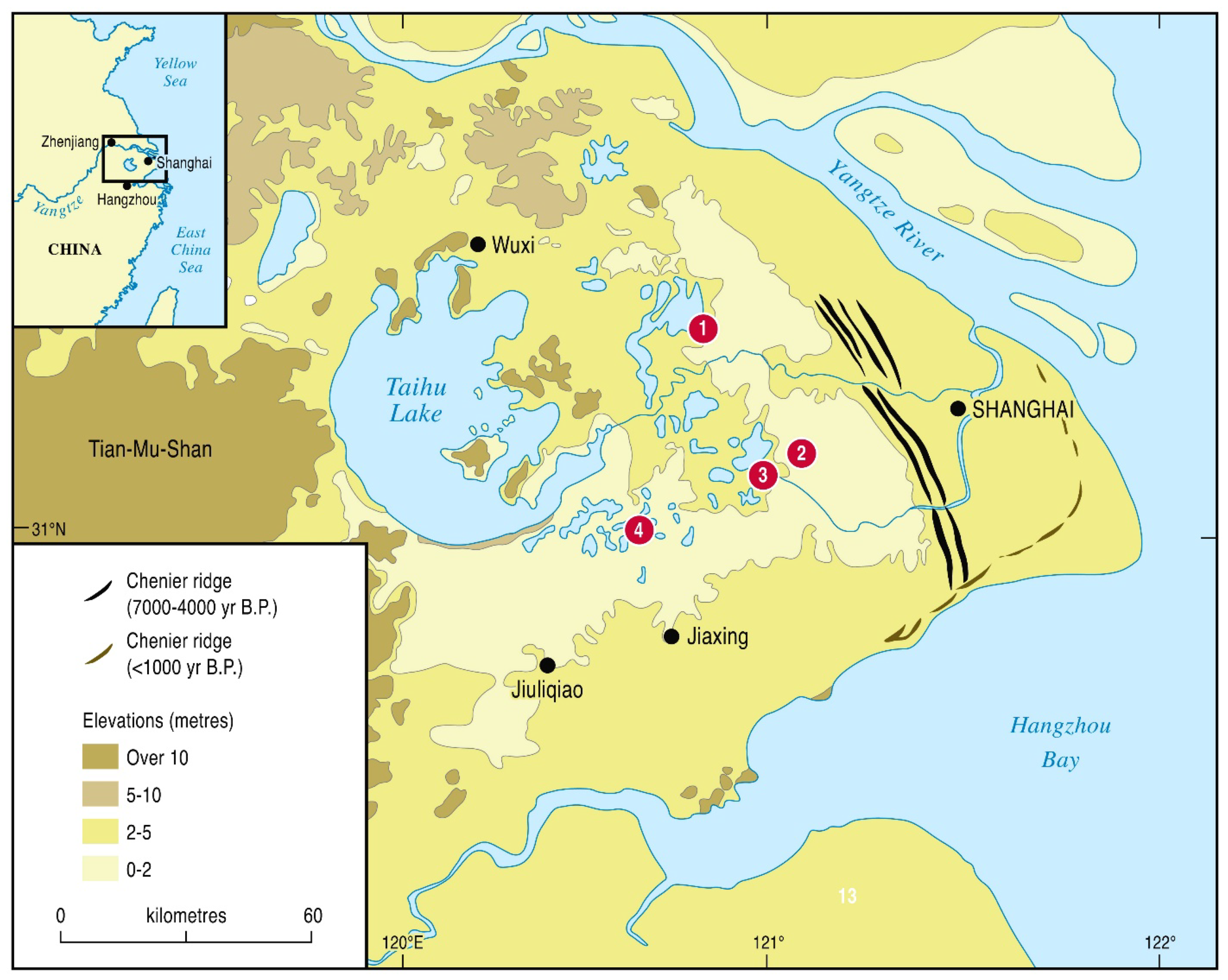
2. The Study Area—Geological and Environmental Settings
2.1. The Yangtze Delta and the Taihu Lowlands

2.2. Recognition of Past Hydrological Changes
2.3. Climate and Precipitation Changes
2.4. Yangtze Floods
3. Materials and Methods
4. Results
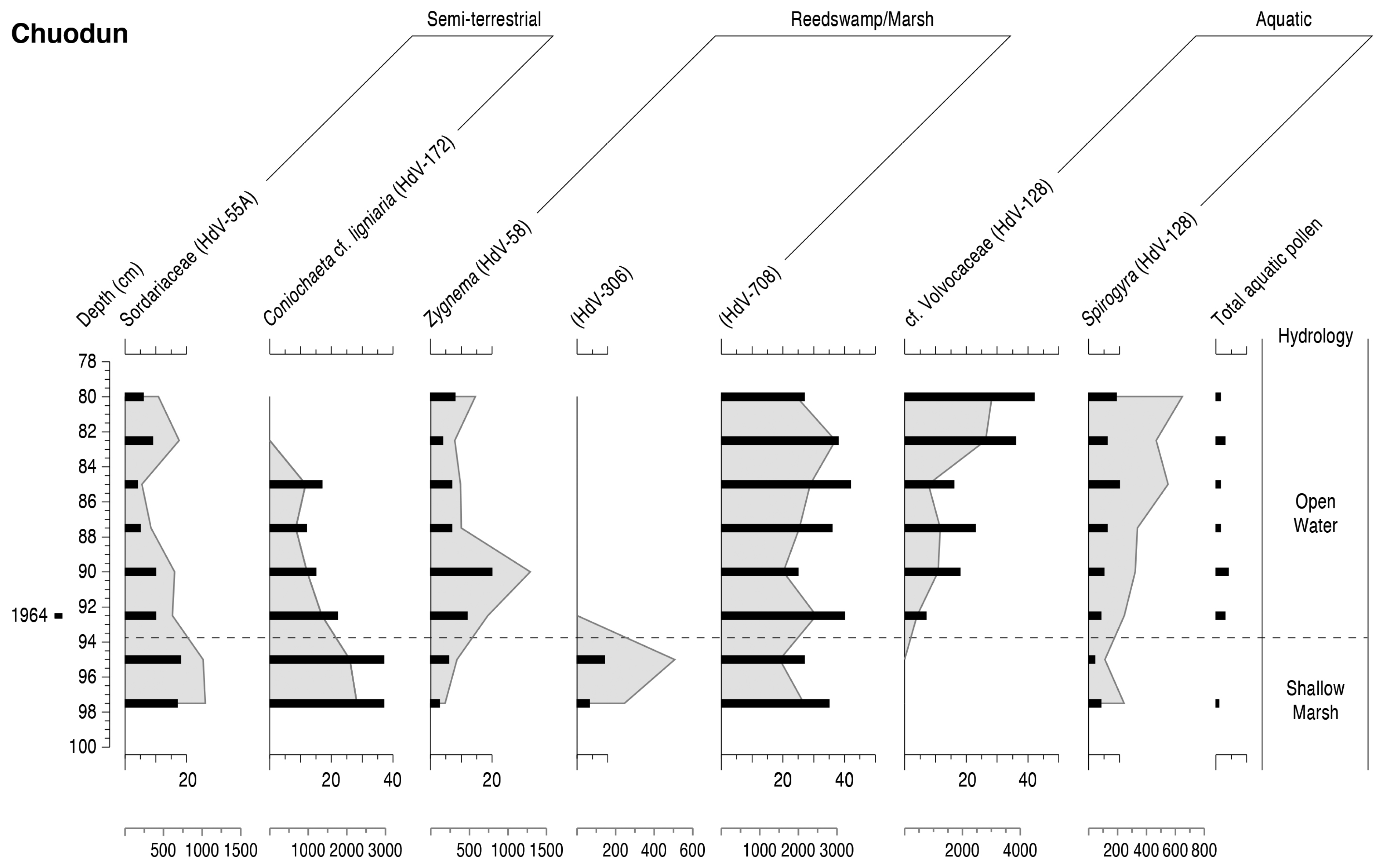
4.1. Chuodun
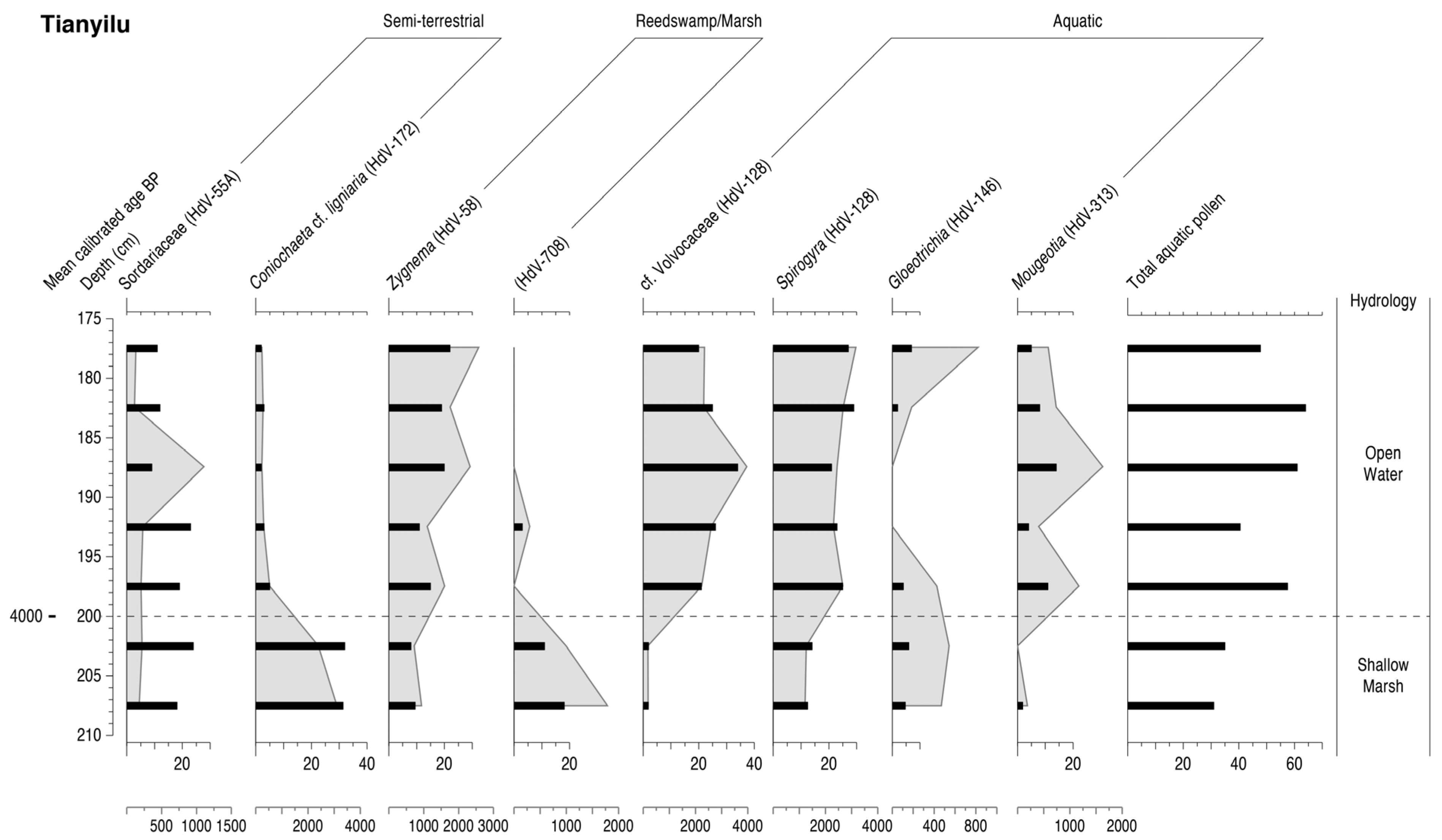
4.2. Tianyilu
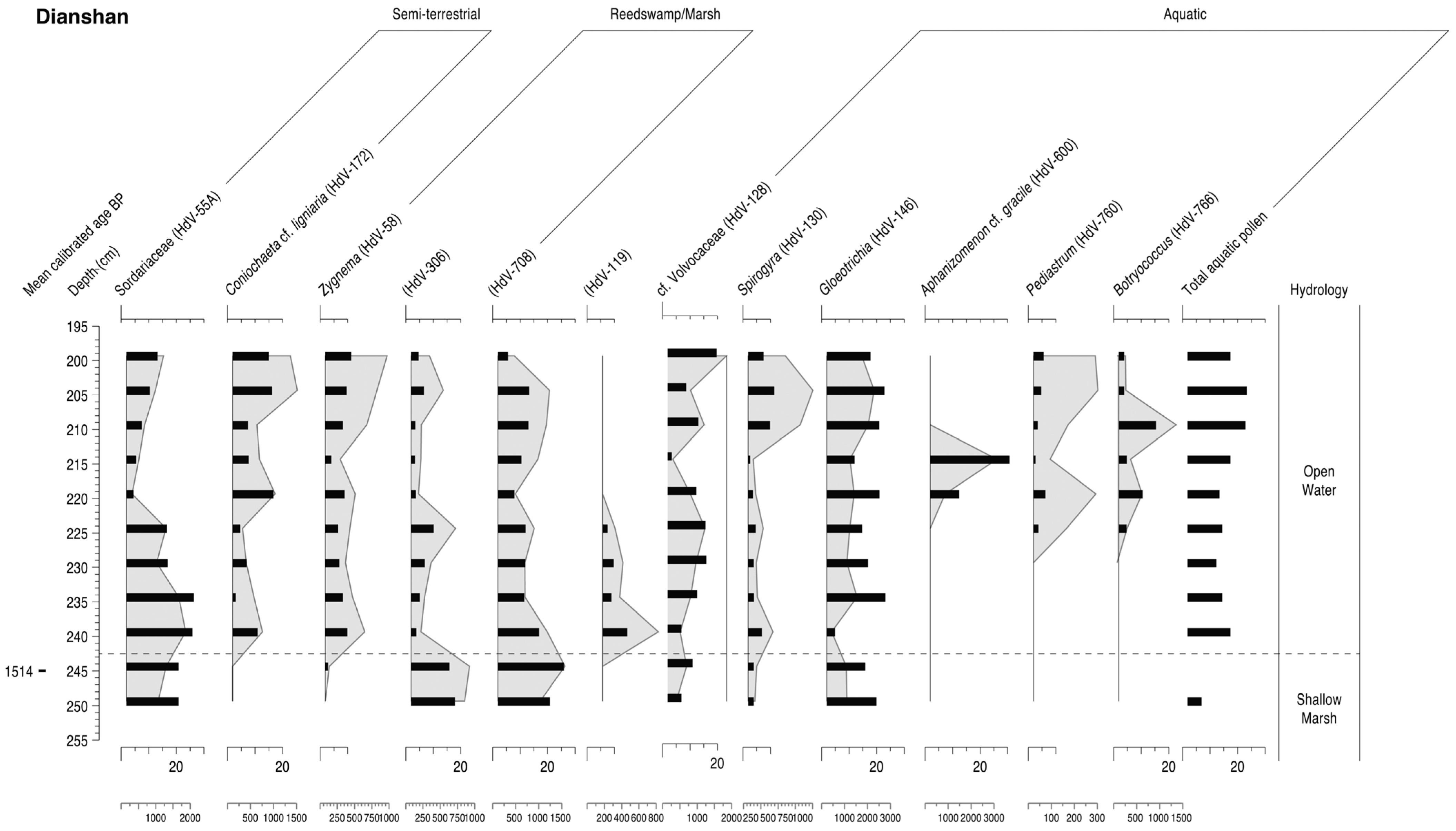
4.3. Dianshan
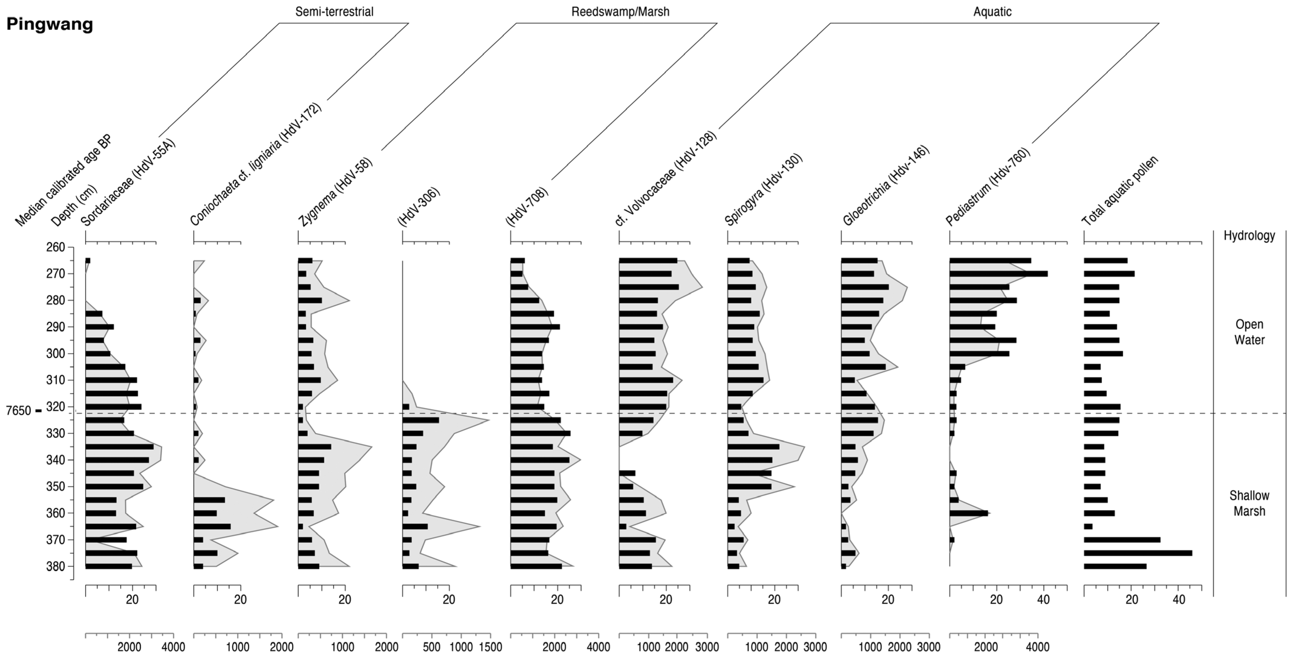
4.4. **wang

4.5. Summary

5. Discussion
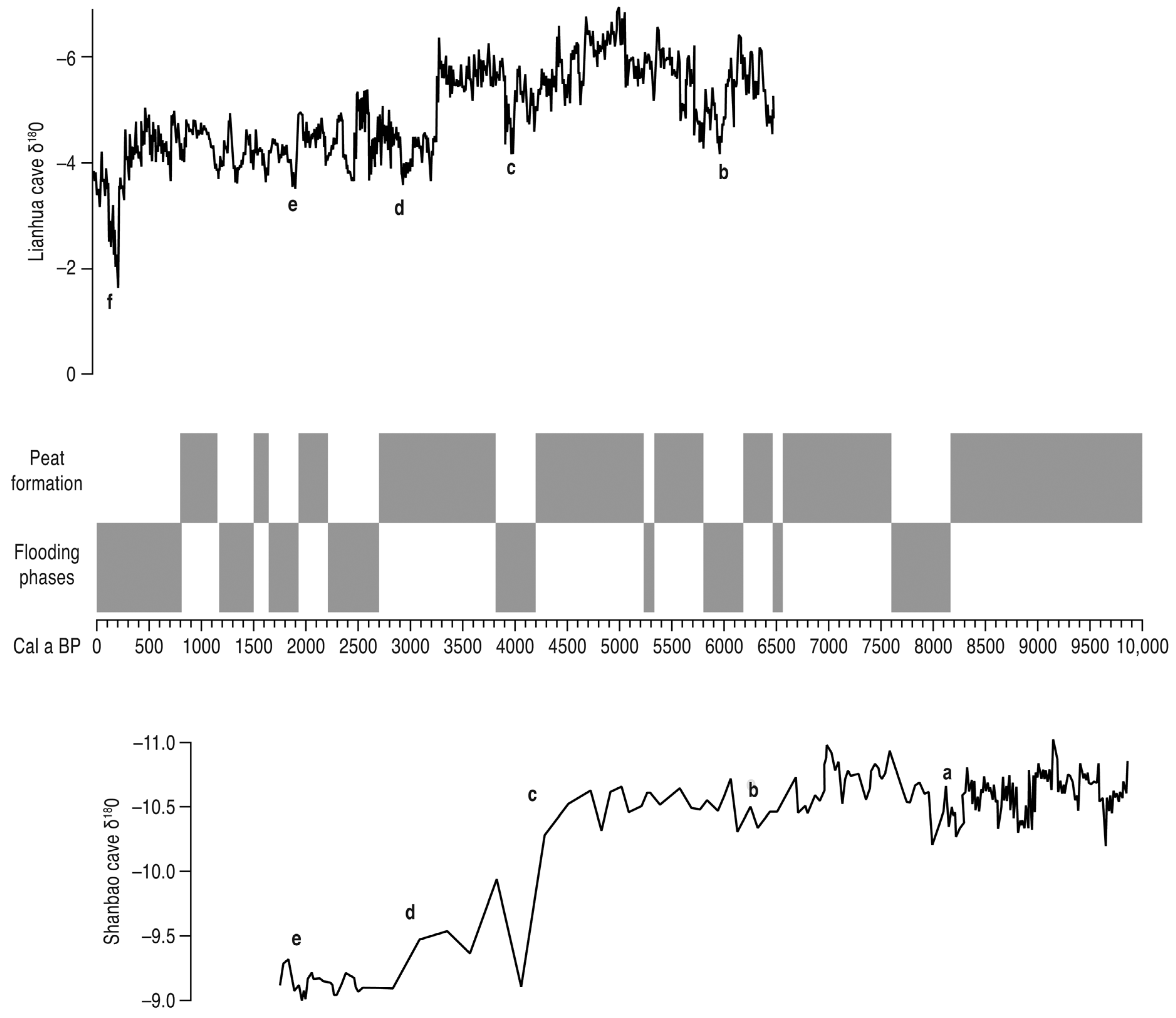
5.1. Hydrology of the Taihu Lowland Plain
5.2. Terrestrialisation and Peat Formation

| Site | Median Age of Peat |
|---|---|
| D2 [327] | 1050 |
| Yaojiang [146] | 1321 |
| T-1 [336] | 1350 |
| Longnan [337] | 1500–1400 |
| Dianshan [81] | 1514 |
| D2 [327] | 1700 |
| Taihu plain [332] | 1710–1414 |
| Qingpu [313] | 2500 |
| Yushan [98] | 2540 |
| YZ-1 [327] | 2651 |
| Taihu plain [332] | 3110–2818 |
| Dong**g [52] | 3177–3111 |
| Taihu plain [332] | 3630 |
| Dong**g [52] | 3657–3639 |
| Guoyuancun [303] | 3795–3710 |
| Baiwaitan [52] | 4291 |
| Maoshan [149] | 4464 |
| Banxiangchan [52] | 4577 |
| Liangzhu (LZ-1) [273] | 4620 |
| Wuguishan [338] | 4630 |
| Yangxi [30] | 4700 |
| HB3 [339] | 4886 |
| Hemudu [188] | 4924–4603 |
| Luojiang [5,311] | 4940–4620 |
| Yushan [340] | 4903 |
| Taihu plain [332] | 5129–4346 |
| Liangzhu (LZ-4) [273] | 5175 |
| **gtoushan [341] | 5200– 5000 |
| Tianluoshan [11] | 5326 |
| Yaojiang [25] | 5386 |
| Shisanzuqiao [332] | 5434–5347 |
| Tiaoxi valley [1] | 5445 |
| **aofengyang [52] | 5517 |
| Feng**g [52] | 5680 |
| Wuguishan [338] | 5815 |
| Hemudu [342] | 6255 |
| **gtoushan [341] | 6350–6200 |
| Hemudu [178] | 6470–6255 |
| Wu**cheng [52] | 6494 |
| Yaojiang [177] | 6509 |
| **gtoushan [341] | 6650–6500 |
| **njie [221] | 6713 |
| Gehu Lake [30] | 6800–6500 |
| Hemudu 1501 [189] | 6932 |
| Luotuodun [343] | 7000 |
| Yuyao [344] | 7000 |
| **njie [221] | 7210 |
| Longnan [337] | 7410 |
| Wujiabang [5] | 7509–7499 |
| Taihu plain [332] | 7554–7134 |
| Beihu [2] | 7914 |
| Beihuqiao [329] | 7989–7883 |
| Beihu [2] | 7990 |
| Maqiao [52] | 8069 |
| Hongkou [52] | 8156 |
| Beihu [2] | 8348 |
| Beihuqiao [329] | 8356 |
| ZX-1 [327] | 8481 |
| ZX-1 [250,323] | 8690–8512 |
| **wang [260] | c.8850 |
| Zhaoxiang [52] | 9072–8847 |
| HL81063 [339] | 10,027 |
5.3. Major Palaeofloods
5.3.1. The Lower Yangtze and Delta
| Site | Median Age of Flood Events |
|---|---|
| Lake Taihu [168] | 400–0 |
| Dianshan [81] | 800 |
| Jiang-nan [127] | 800–400 |
| Jiang-nan [127] | 1400–1200 |
| Longnan [337] | 1300–1200 |
| Chaohu Lake [135] | 1300 |
| Shangshan [361] | 1710 |
| Longnan [337] | 1800–1700 |
| Chuodun [303] | 1964 |
| Chaohu Lake [135] | 2200, 1800 |
| Guangfulin [311] | 2400 |
| Qingfeng [246] | 3900 |
| Maqiao [362] | 4000–3800 |
| Maoshan [149] | 4000–3900 |
| Maoshan [154] | 4000–3900 |
| Chuodun [363] | c.4000 |
| Dadong [363] | c.4000 |
| Dasan** [363] | c.4000 |
| Guoyuancun [363] | c.4000 |
| Liangzhu [363,364] | c.4000 |
| Longtanhu [363] | c.4000 |
| Shuitianfan [363] | c.4000 |
| Tangwanli [363] | c.4000 |
| Tenghualuo [142] | c.4000 |
| Taihu plain [365] | c.4000 |
| Yuanjiadi [363] | c.4000 |
| Wangjiashan [363] | c.4000 |
| Xuxiang [363] | c.4000 |
| Yuecheng [363] | c.4000 |
| Tianyilu [303] | 4030 |
| Yuhuicun [366] | 4100 |
| XL [367] | 4200 |
| Caoxieshan [246] | 5250 |
| Baohuashan [246] | 5860 |
| Fuquanshan [246] | 6020 |
| Songze [246] | 6170 |
| Huaihe valley [368] | 6250–5500 |
| Qingfeng [139] | 6400–5500 |
| **gtoushan [341] | 6500 |
| **wang [260] | 7650 |
| HG01 [176] | 7700 |
| Taihu plain [139] | 8100–7700 |
| Lower Yangtze [141] | 9200–8000 |

5.3.2. The Upper and Middle Yangtze
| Site | Median Age of Flood Event |
|---|---|
| Wufeng [349] | 400 |
| Weibicun [160] | 600 |
| Poyang [401] | 800–0 |
| Nanchang [288] | 840–772 |
| Weibicun [160] | 1000–800 |
| Luojiatan [153] | 1800–1700 |
| Liaowadian [151,166] | 1800 |
| Weibicun [160] | 1800 |
| Zhangjiawan [403] | 1800 |
| **ntancun [166] | 1900–1700 |
| Weibicun [160] | 2200 |
| Liaowadian [151,166] | 2200 |
| Majie [400] | 2610 |
| Longgan Lake [278] | 2700 |
| Hanjiang TJW [158] | c.3000 |
| Weihe GCZ [158] | c.3100 |
| Luojiatan [153,166] | 3200–2800 |
| East Dongting [387] | 3900 |
| Baodun [399] | 4000–3800 |
| Caitai [376] | c.4000 |
| Chengtoushan [369] | c.4000 |
| Longgan Lake [278] | c.4000 |
| Dongting [391] | c.4000 |
| Lajia [404] | c.4000 |
| Jianghan [171] | c.4000 |
| Hongqiacun [170] | c.4000 |
| **sha [145,170] | c.4000 |
| Mangcheng [399] | c.4000 |
| Three Gorges [29] | c.4000 |
| Shuanghe [399] | c.4000 |
| Zhongba [148] | c.4000 |
| Yichang [405] | c.4000 |
| Yuxi [375] | c.4000 |
| Wulinji [376] | c.4000 |
| Zhongqiao [119,170] | 4100–3800 |
| Zhongqiao [119,170] | 4168 |
| Tanjialing [294] | 4200–4000 |
| Luojiatan [153] | 4200 |
| Zhongqiao [119] | 4900–4600 |
| Dongting [391] | 5800 |
| T0403 Yuxi [295] | 6800–6300 |
| T0403 Yuxi [295] | 7600–7250 |
| Dajiuhu [354] | 9500–7500 |
5.4. Influence of Hydrology on Human Settlement and Land Use
6. Conclusions
Author Contributions
Funding
Institutional Review Board Statement
Informed Consent Statement
Data Availability Statement
Acknowledgments
Conflicts of Interest
References
- Chen, T.; Ryves, D.B.; Wang, Z.; Lewis, J.P.; Yu, X. Mid- to late Holocene geomorphological and hydrological changes in the south Taihu area of the Yangtze delta plain, China. Palaeogeogr. Palaeoclimatol. Palaeoecol. 2018, 498, 127–142. [Google Scholar] [CrossRef] [Green Version]
- Zhang, Y.; Ye, W.; Ma, C.; Li, Y.; Li, C.; Zhu, L. Middle to late Holocene changes in climate, hydrology, vegetation and culture on the Hangjiahu Plain, southeast China. J. Palaeolimnol. 2020. [Google Scholar] [CrossRef]
- Yan, Q.; Huang, S. Evolution of Holocene sedimentary environment in the Hangzhou-Jiaxing-Huzhou Plain. Acta Geogr. Sin. 1987, 42, 1–15. [Google Scholar]
- Yan, Q.; Shao, X. Evolution of shorelines along the north bank of Hangzhou Bay during the late stage of the Holocene transgression. Sci. China B 1989, 32, 347–360. [Google Scholar]
- Qin, J.; Taylor, D.; Atahan, P.; Zhang, X.; Wu, G.; Dodson, J.; Zheng, H.; Itzstein-Davey, F. Neolithic agriculture, freshwater resources and rapid environmental changes on the lower Yangtze, China. Quat. Res. 2011, 75, 55–65. [Google Scholar] [CrossRef]
- Chen, Z.; Song, B.; Wang, Z.; Cai, Y. Late Quaternary evolution of the sub-aqueous Yangtze Delta, China: Sedimentation, stratigraphy, palynology, and deformation. Mar. Geol. 2000, 162, 423–441. [Google Scholar] [CrossRef]
- Yang, X.; Anderson, N.J.; Dong, X.; Shen, J. Surface sediment diatom assemblages and epilimnetic total phosphorous in large, shallow lakes of the Yangtze floodplain: Their relationships and implications for assessing long-term eutrophication. Freshw. Biol. 2008, 53, 1273–1290. [Google Scholar] [CrossRef]
- ** Hemudu culture in the lower Yangtze River, China. Quat. Sci. Rev. 2018, 188, 90–103. [Google Scholar] [CrossRef]
- Deng, L.; Liu, Y.; He, J.; Jiang, R.; Jiang, F.; Chen, J.; Chen, Z.; Sun, Q. New archaeobotanical evidence reveals synchronous rice domestication 7600 years ago on south Hangzhou Bay coast, eastern China. Anthropocene 2021, 33, 100280. [Google Scholar] [CrossRef]
- Zheng, Y.; Zheng, H.; Guo, Q.; Yang, Q.; Hu, Z.; Yao, X.; Zhou, X.; Zhao, K.; Li, X.; Deng, C. Dating the Hemudu Neolithic rice cultivation site, East China, by palaeomagnetic chronostratigraphy. Palaeogeogr. Palaeoclimatol. Palaeoecol. 2021, 569, 110297. [Google Scholar] [CrossRef]
- Li, L.; Zhu, C.; Lin, L.; Zhao, Q.; Shi, G.; Zhu, H. Transgression records between 7500–5400 BC on the stratum of the Luotuodun site in Yixing, Jiangsu province. Acta Geogr. Sin. 2008, 63, 1189–1197. [Google Scholar]
- Zheng, H.; Zhou, Y.; Yang, Q.; Hu, Z.; Ling, G.; Zhang, J.; Gu, C.; Wang, Y.; Cao, Y.; Huang, X.; et al. Spatial and temporal distribution of Neolithic sites in coastal China: Sea level changes, geomorphic evolution and human adaption. Sci. China Earth Sci. 2018, 61, 123–133. [Google Scholar] [CrossRef]
- Zhang, D. Meteorological Record Collection in China over the Last 3,000 Years; Jiangsu Education Press: Nan**g, China, 2013. [Google Scholar]
- Yin, S.; Wang, H.; Wang, D.; Huang, C. Study on historical flood disasters and climate change in the upper reaches of the Hanjiang River. Arid Zone Res. 2010, 27, 522–528, (In Chinese with English abstract). [Google Scholar]
- Huang, C.; Pang, J.; Zha, X.; Zhou, Y.; Su, H.; Wan, H.; Ge, B. Sedimentary records of extraordinary floods at the ending of the mid-Holocene climatic optimum along the Upper Weihe river, China. Holocene 2012, 22, 675–686. [Google Scholar] [CrossRef]
- Li, X.; Huang, C.; Pang, J.; Zhou, Y. Palaeoflood hydrological study in the Baihe Reach in the upper reaches of the Hanjiang River. Sci. Geogr. Sin. 2012, 32, 971–978, (In Chinese with English abstract). [Google Scholar]
- Liu, T.; Huang, C.; Pang, J.; Zha, X.; Zhou, Y.; Zhang, Y.; Liu, K. Hydrological reconstructions of the pre-historical great floods in the Wufeng Reach of Yunxian County in the upper Hanjiang River. Acta Geogr. Sin. 2013, 68, 1568–1577, (In Chinese with English abstract). [Google Scholar]
- Zha, X.; Huang, C.; Pang, J.; Li, Y. Sedimentary and hydrological studies of the Holocene palaeofloods in the middle reaches of the **ghe River. J. Geogr. Sci. 2012, 22, 470–478. [Google Scholar] [CrossRef]
- Zhang, J.; Chen, F.; Holmes, J.A.; Li, H.; Guo, X.; Wang, J.; Li, S.; Lu, Y.; Zhao, Y.; Qiang, M. Holocene monsoon climate documented by oxygen and carbon isotopes from lake sediments and peat bogs in China: A review and synthesis. Quat. Sci. Rev. 2011, 30, 1973–1987. [Google Scholar] [CrossRef]
- Li, D.; Yao, P.; Bianchi, T.S.; Zhao, B.; Pan, H.; Zhang, T.; Wang, J.; Xu, B.; Yu, Z. Historical reconstruction of organic carbon inputs to the East China Sea inner shelf: Implications for anthropogenic activities and regional climate variability. Holocene 2015, 25, 1869–1881. [Google Scholar] [CrossRef]
- Zhu, Z.; Feinberg, J.M.; **e, S.; Bourne, M.D.; Huang, C.; Hu, C.; Cheng, H. Holocene ENSO-related cyclic storms recorded by magnetic minerals in speleothems of central China. Proc. Natl. Acad. Sci. USA 2017, 114, 852–857. [Google Scholar] [CrossRef] [Green Version]
- Liu, H.; Gu, Y.; Huang, X.; Yu, Z.; **e, S.; Cheng, S. A 13,000-year peatland palaeohydrological response to the ENSO-related Asian monsoon precipitation changes in the middle Yangtze Valley. Quat. Sci. Rev. 2019, 212, 80–91. [Google Scholar] [CrossRef]
- Liu, Z.; Wen, X.; Brady, E.C.; Otto-Bliesner, B.; Yu, G.; Lu, H.; Cheng, H.; Wang, Y.J.; Zheng, W.; Ding, Y.; et al. Chinese cave records and the East Asia Summer Monsoon. Quat. Sci. Rev. 2014, 83, 115–128. [Google Scholar] [CrossRef]
- Donges, J.; Donner, R.; Marwan, N.; Breitenbach, S.F.; Rehfeld, K.; Kurths, J. Non-linear regime shifts in Holocene Asian monsoon variability: Potential impacts on cultural change and migratory patterns. Clim. Past 2015, 11, 709–741. [Google Scholar] [CrossRef] [Green Version]
- Shu, J.; Wang, W.; Chen, W. Holocene vegetation and environment changes in the NW Taihu plain, Jiangsu Province, east China. Acta Micropaleontol. Sin. 2007, 24, 210–221. [Google Scholar]
- **e, S.; Evershed, R.P.; Huang, X.; Zhu, Z.; Pancost, R.D.; Meyers, P.A.; Gong, L.; Hu, C.; Huang, J.; Zhang, S.; et al. Concordant monsoon-driven postglacial hydrological changes in peat and stalagmite records and their impacts on prehistoric cultures in central China. Geology 2013, 41, 827–830. [Google Scholar] [CrossRef] [Green Version]
- Zuo, X.; Lu, H.; Li, Z.; Song, B.; Xu, D.; Zou, Y.; Wang, C.; Huan, X.; He, K. Phytolith and diatom evidence for rice exploitation and environmental changes during the early mid-Holocene in the Yangtze Delta. Quat. Res. 2016, 86, 304–315. [Google Scholar] [CrossRef]
- Qin, B.; Yu, G. Implications of lake level variations at 6 ka and 18 ka in mainland Asia. Glob. Planet. Chang. 1998, 18, 59–72. [Google Scholar] [CrossRef]
- Mao, L.; Mo, D.; Jiang, L.; Jia, Y.; Liu, X.; Li, M.; Zhou, K.; Shi, C. Environmental change since mid-Pleistocene recorded in Shangshan archaeological site of Zhejiang. J. Geogr. Sci. 2008, 18, 247–256. [Google Scholar] [CrossRef]
- Zhu, C.; Song, J.; You, K.; Han, H. Research on the reasons of culture interruption in Maqiao Site. Chin. Sci. Bull. 1996, 41, 148–152. (In Chinese) [Google Scholar]
- Zhang, Q.; Liu, C.; Zhu, C.; Jiang, T. Environmental change and its impacts on human settlement in the Changjiang river delta in Neolithic age. Chin. Geogr. Sci. 2004, 14, 239–244. [Google Scholar] [CrossRef]
- Shi, W.; Ma, C.M.; Zhu, C.; Wang, F.B.; Li, S.J. Analysis of stratigraphy on multiprofiles in the Taihu Lake region and palaeoenvironmental events in the Liangzhu culture epoch. Geogr. Res. 2008, 27, 1129–1138. (In Chinese) [Google Scholar]
- Stanley, D.J.; Chen, Z. Neolithic settlement distributions as a function of sea level controlled topography in the Yangtze Delta, China. Geology 1996, 24, 1083–1086. [Google Scholar] [CrossRef]
- Zhang, G.; Zhu, C.; Wang, J.; Zhu, G.; Ma, C.; Zheng, C.; Zhao, L.; Li, Z.; Li, L.; **, A. Environmental archaeology on Longshan culture (4500–4000 a BP) at Yuhuicun site in Bengbu, Anhui Province. J. Geogr. Sci. 2010, 20, 455–468. [Google Scholar] [CrossRef]
- Liu, Y.; Ma, C.; Fan, D.; Sun, Q.; Chen, J.; Li, M.; Chen, Z. The Holocene environmental evolution of the Inner Hangzhou Bay and its significance. J. Ocean. Univ. China 2018, 17, 1301–1308. [Google Scholar] [CrossRef]
- Huang, R.; Zhu, C.; Guan, Y.; Zheng, C. Impact of Holocene environmental change on temporal-spatial distribution of Neolithic sites in Huaihe River Basin, Anhui Province. J. Geogr. Sci. 2006, 16, 199–208. [Google Scholar] [CrossRef]
- Yasuda, Y.; Fujiki, T.; Nasu, H.; Kato, M.; Morita, Y.; Mori, Y.; Kanehara, M.; Toyama, S.; Yano, A.; Okuno, M.; et al. Environmental archaeology at the Chengtoushan site, Hunan Province, China, and implications for environmental change and the rise and fall of the Yangtze River civilization. Quat. Int. 2004, 123–125, 149–158. [Google Scholar] [CrossRef]
- Wang, S.; Huang, J.; Wen, X.; Zhu, J. Evidence and modeling study of droughts in China during 4–2 ka BP. Chin. Sci. Bull. 2008, 53, 2215–2221. [Google Scholar] [CrossRef] [Green Version]
- Wu, W.; Zheng, H.; Hou, M.; Ge, Q. The 5.5 cal ka BP climate event, population growth, circumscription and the emergence of the earliest complex societies in China. Sci. China Earth Sci. 2018, 61, 134–148. [Google Scholar] [CrossRef]
- Wu, L.; Sun, X.; Sun, W.; Zhu, C.; Zhu, T.; Lu, S.; Zhou, H.; Guo, Q.; Guan, H.; **e, W.; et al. Evolution of Neolithic site distribution (9.0–4.0 ka BP) in Anhui, East China. J. Geogr. Sci. 2020, 30, 1451–1456. [Google Scholar] [CrossRef]
- He, Y.; Theakstone, W.H.; Zhang, Z.; Zhang, D.; Yao, T.; Chen, T.; Shen, Y.; Pang, H. Asynchronous Holocene climatic change across China. Quat. Res. 2004, 61, 52–63. [Google Scholar] [CrossRef]
- Tan, L.; An, Z.; Cai, Y.; Long, H. Hydrological representation of the 4.2 ka BP event in China and its global linkages. Geol. Rev. 2008, 54, 94–104. (In Chinese) [Google Scholar]
- Bai, J.; Zhou, H.; Zhu, C. Archaeological discovery and research on the remains of the palaeoflood of the Yuxi site. Chin. Sci. Bull. 2008, 53 (Suppl. 1), 18–27. [Google Scholar]
- Zhao, C.; Mo, D. Holocene hydro-environmental evolution and its impacts on human occupation in Jianghan-Dongting Basin, middle reaches of the Yangtze River, China. J. Geogr. Sci. 2020, 30, 423–438. [Google Scholar] [CrossRef]
- Okuda, M.; Sato, Y.; Tang, L.; Takahashi, M.; Toyama, S.; Yano, A.; Kitagawa, H.; Yasuda, Y. Late Holocene vegetation and environment at Cauduntou, west of Yangtze Delta, SW Jiangsu Province, East China. Quat. Int. 2003, 105, 39–47. [Google Scholar] [CrossRef]
- Guo, F.; Hu, Q.; Jiang, T. Annual and seasonal streamflow responses to climate and land-cover changes in the Poyang Lake basin, China. J. Hydrol. 2008, 355, 106–122. [Google Scholar] [CrossRef]
- Ma, T.; Rolett, B.V.; Zheng, Z.; Zong, Y. Holocene coastal evolution preceded the expansion of paddy field rice farming. Proc. Natl. Acad. Sci. USA 2020, 117, 24138–24143. [Google Scholar] [CrossRef] [PubMed]
- Yi, S.; Saito, Y.; Zhao, Q.; Wang, P. Vegetation and climate changes in the Changjiang Yangtze River Delta, China, during the past 13,000 years inferred from pollen records. Quat. Sci. Rev. 2003, 22, 1501–1519. [Google Scholar] [CrossRef]
- Song, J. Changes in dryness/wetness in China during the last 529 years. Int. J. Climatol. 2000, 20, 1003–1015. [Google Scholar] [CrossRef] [Green Version]
- Gemmer, M.; Jiang, T.; Su, B.; Kundzewicz, Z.W. Seasonal precipitation changes in the wet season and their influence on flood/drought hazards in the Yangtze river basin, China. Quat. Int. 2008, 186, 12–21. [Google Scholar] [CrossRef]
- Su, B.; Gemmer, M.; Jiang, T. Spatial and temporal variation of extreme precipitation over the Yangtze River Basin. Quat. Int. 2008, 186, 22–31. [Google Scholar] [CrossRef]
- Chen, W.; Wang, W.; Dai, X. Holocene vegetation history with implication of human impact in the lake Chaohu area, Anhui Province, East China. Veget. Hist. Archaeobot. 2009, 18, 137–146. [Google Scholar] [CrossRef]
- Jiang, T.; Zhang, Q.; Blender, R.; Fraedrich, K. Yangtze Delta floods and droughts of the last millennium: Abrupt changes and long term memory. Theoret. App. Climatol. 2005, 82, 131–141. [Google Scholar] [CrossRef]
- Min, Q.; Wang, Z. On the regularity of flood occurrences in Poyang Lake in the past 600 years. J. Lake Sci. 1994, 6, 375–383. [Google Scholar]
- Zhang, X.; Cai, S.; Sun, S. Evolution of Dongting Lake since Holocene. J. Lake Sci. 1994, 6, 13–21. (In Chinese) [Google Scholar]
- Du, Y.; Cai, S.; Zhang, X.; Zhao, Y. Interpretation of the environmental change of Dongting Lake, middle reach of Yangtze River, China, by 210Pb measurement and satellite image analysis. Geomorphology 2001, 41, 171–181. [Google Scholar] [CrossRef]
- Dai, S.; Yang, S.; Zhu, J.; Gao, A.; Li, P. The role of Lake Dongting in regulating the sediment budget of the Yangtze River. Hydrol. Earth Syst. Sci. 2005, 9, 692–698. [Google Scholar] [CrossRef] [Green Version]
- Shankman, C.; Keim, B.D.; Song, J. Flood frequency in China’s Poyang Lake region: Trends and teleconnections. Int. J. Climatol. 2006, 26, 1255–1266. [Google Scholar] [CrossRef] [Green Version]
- Liu, T.; Chen, Z.; Sun, Q.; Finlayson, B. Migration of Neolithic settlements in the Dongting Lake area of the middle Yangtze River basin, China: Lake-level and monsoon climate responses. Holocene 2012, 22, 649–657. [Google Scholar] [CrossRef]
- Xu, J.; Jian, Y.; Ma, C.; Zhu, C.; Wu, L.; Li, Y.; Wang, X. Geographic distribution of archaeological sites and their response to climate and environmental changes between 10.0-2.8 ka BP in the Poyang Lake Basin, China. J. Geogr. Sci. 2016, 26, 603–618. [Google Scholar] [CrossRef] [Green Version]
- **e, Y.; Li, C.; Wang, Q.; Yin, H. Sedimentary records of paleoflood events during the last 3000 years in Jianghan Plain. Sci. Geogr. Sin. 2007, 27, 81–84. (In Chinese) [Google Scholar]
- Shi, C.; Mo, D.; Liu, H.; Mao, L.J. Late Neolithic culture evolution and environmental changes in northern Jianghan Plain east of Hanjiang River. Quat. Sci. 2010, 30, 335–343, (In Chinese with English abstract). [Google Scholar]
- Wu, L.; Zhu, C.; Li, F.; Ma, C.; Li, L.; Meng, H.; Liu, H.; Wang, X.; Tan, Y.; Song, Y. Prehistoric flood events recorded at the Zhongqiao Neolithic site in the Jianghan Plain, Central China. Acta Geogr. Sin. 2015, 70, 1149–1164. (In Chinese) [Google Scholar]
- Wu, X.; Wu, J. The Neolithic sites distribution and its relationship with paleo-environmental changes around Dongting lake area, China. Southeast. Cult. 1998, 1, 35–40. (In Chinese) [Google Scholar]
- Mo, D.; Zhao, Z.; Xu, J.; Li, M. Holocene environmental changes and the evolution of the Neolithic cultures in China. In Landscapes and Societies; Martini, I.P., Chesworth, W., Eds.; Springer: Dordrecht, The Netherlands, 2010; pp. 299–319. [Google Scholar]
- Yasuda, Y. Climate change and the origin and development of rice cultivation in the Yangtze River basin, China. Ambio 2008, 37, 502–506. [Google Scholar] [CrossRef]
- Zeng, M.; Ma, C.; Zhu, C.; Song, Y.; Zhu, T.; He, K.; Chen, J.; Huang, M.; Jia, T.; Guo, T. Influence of climate change on the evolution of ancient culture from 4500 to 3700 cal. yr BP in the Chengdu Plain, upper reaches of the Yangtze River, China. Catena 2016, 147, 742–754. [Google Scholar] [CrossRef]
- Zhu, C.; Xu, J.; Huang, M.; Yang, Z.; Zhang, N.; Jiang, Z.; Bai, T.; Lu, F. Archaeological discoveries and research on the remains of an ancient flood event at the Majie site in the Chengdu Plain. Front. Earth Sci. 2021, 28, 181–201. [Google Scholar]
- He, L.; Chen, J.; Yang, L.E.; Li, G.; Lu, C. Social resilience to climate and water-related disasters in the Poyang Lake area (East China) over the past 2000 years. Environ. Res. Lett. 2021, 16, 045007. [Google Scholar] [CrossRef]
- Li, X.; Zhang, Q. Variation of floods characteristics and their responses to climate and human activities in Poyang lake, China. Chin. Geogr. Sci. 2015, 25, 13–25. [Google Scholar] [CrossRef] [Green Version]
- Zhang, Y.; Zhu, C. Environmental archaeology of the Dachang region in the Daning valley, the Three Gorges reservoir region of the Yangtze River, China. Chin. Sci. Bull. 2008, 53, 140–152. [Google Scholar] [CrossRef] [Green Version]
- **a, Z.; Yang, X.; Ye, M. Prehistoric disasters at Lajia site, Qinghai, China. Chin. Sci. Bull. 2003, 48, 1877–1881. [Google Scholar]
- Ge, Z.; Yang, D.; Li, X.; Ren, Z. The paleoflooding record along the upreaches of the Yangtze River since the late pleistocene epoch. Quat. Sci. 2004, 24, 556–560, (In Chinese with English abstract). [Google Scholar]
- **, Z.; Yu, J.; Chen, H.; Wu, Y.; Wang, S.; Chen, S. The influence and chronological uncertainties of the 8.2 ka cooling event on continental climate records in China. Holocene 2007, 17, 1041–1050. [Google Scholar] [CrossRef]
- Zhu, C.; Shi, W.; Song, Y. Environmental archaeological study on paleoflood since 7 ka BP in the Changjiang River delta. In Research on Mountains Disasters and Environmental Protection across Taiwan Strait (Series1); Cui, P., Ed.; Sichuan Sciences & Technology Press: Chengdu, China, 1998; pp. 85–90. (In Chinese) [Google Scholar]
- Zhu, C.; Wu, L.; Li, L.; Zheng, C.; Li, Z.; Ma, C.; Tan, Y.; Zhao, Q.; Wang, K.; Lin, L.; et al. Research progress on Holocene environmental archaeology in the Yangtze River Valley, China. Acta Geogr. Sin. 2014, 69, 1268–1283. (In Chinese) [Google Scholar]
- Zhu, C.; Zheng, C.; Wu, L. Environmental Archaeology since the Neolithic Age in the Yangtze River Valley, China; Science Press: Bei**g, China, 2015. (In Chinese) [Google Scholar]
- Wu, L.; Lu, S.; Zhu, C.; Ma, C.; Sun, X.; Li, X.; Li, C.; Guo, Q. Holocene environmental archaeology of the Yangtze River Valley in China, a review. Land 2021, 10, 302. [Google Scholar] [CrossRef]
- Jiang, L. (Ed.) Kuahuqiao; Wenwu Press: Bei**g, China, 2004. (In Chinese) [Google Scholar]
- Zheng, Y.; Sun, G.; Qin, L.; Li, C.; Wu, X.; Chen, X. Rice fields and modes of rice cultivation between 5000 and 2500 BC in east China. J. Arch. Sci. 2009, 36, 2609–2616. [Google Scholar]
- Sun, G. Recent research on the Hemudu culture and the Tianluoshan site. In A Companion to Chinese Archaeology; Underhill, A.P., Ed.; Wiley-Blackwell: West Sussex, UK, 2013; pp. 555–573. [Google Scholar]
- Yuan, J.; Flad, R.; Luo, Y. Meat-acquisition patterns in the Neolithic Yangzi river valley, China. Antiquity 2008, 82, 351–366. [Google Scholar]
- Fuller, D.Q.; Qin, L. Declining oaks, increasing artistry, and cultivating rice: The environmental and social context of the emergence of farming in the Lower Yangtze Region. Environ. Archaeol. 2010, 15, 139–159. [Google Scholar] [CrossRef]
- Qiu, Z.; Shang, X.; Ferguson, D.K.; Jiang, H. Archaeobotanical analysis of diverse plant food resources and palaeovegetation at the Zhumucun site, a late Neolithic settlement of the Liangzhu culture in East China. Quat. Int. 2016, 426, 75–85. [Google Scholar] [CrossRef]
- Yao, L.; Yang, Y.; Sun, Y.; Cui, Q.; Zhang, J.; Wang, H. Early Neolithic human exploitation and processing of plant foods in the Lower Yangtze River, China. Quat. Int. 2016, 426, 56–64. [Google Scholar] [CrossRef]
- Zhang, Y. Exploring the wetland: Integrating the fish and plant remains into a case study from Tianluoshan, a Middle Neolithic site in China. In Environmental Archaeology: Interdisciplinary Contribution to Archaeology; Pişkin, E., Marciniak, A., Bartkowiak, M., Eds.; Springer International Publishing AG: Cham, Switzerland, 2018; pp. 199–227. [Google Scholar]
- Zhang, Y. Causes of Liangzhu culture’s disappearance from micropaleontology. Sci. Geogr. Sin. 2007, 27, 376–379. [Google Scholar]
- Yu, S.; Zhu, C.; Qu, W. Mid-Holocene climatic transition and rapid interruption in Neolithic cultures in the eastern plain of Taihu Lake. Sci. Geogr. Sin. 1999, 19, 549–554, (In Chinese with English abstract). [Google Scholar]
- Zhang, L.; Wu, J.; Liu, S. Relationship between human activities and environmental changes in the Yangtze Delta of China before Qin Dynasty. Acta Geogr. Sin. 2000, 55, 661–670, (In Chinese with English abstract). [Google Scholar]
- Deng, H.; Chen, Y.; Jia, J.; Mo, D.; Zhou, K. Distribution patterns of the ancient cultural sites in the middle reaches of the Yangtze River since 8500 a BP. Acta Geogr. Sin. 2009, 64, 1113–1125. (In Chinese) [Google Scholar]
- Chen, L. Progress in environmental evolvement and environmental archaeology study in the Yangtze Delta (China). Geo-Spatial Inf. Sci. 2008, 11, 228–234. [Google Scholar] [CrossRef]
- Zhang, Y.; Zhu, C.; Shi, W. Middle and late Holocene climatic changes and sea level changes and paleo-floods of Maqiao, Shanghai. Mar. Sci. 2002, 26, 54–58, (In Chinese with English abstract). [Google Scholar]
- Wiener, M. The interaction of climate change and agency in the collapse of civilisations ca. 2200–2000 BC. Radiocarbon 2014, 56, S1–S16. [Google Scholar] [CrossRef]
- Zhang, X.; Huang, D.; Deng, H.; Snape, C.; Meredith, W.; Zhao, Y.; Du, Y.; Chen, X.; Sun, Y. Radiocarbon dating of charcoal from the Bianjiashan site in Hangzhou: New evidence for the lower age limit of the Liangzhu culture. Quat. Geochron. 2015, 30, 9–17. [Google Scholar] [CrossRef]
- Guo, Y.; Mo, D.; Mao, L.; **, Y.; Guo, W.; Mudie, P.J. Settlement distribution and its relationship with environmental changes from the Paleolithic to Shang-Zhou period in Liyang Plain, China. Quat. Int. 2014, 321, 29–36. [Google Scholar] [CrossRef]
- Wang, X.; Mo, D.; Li, C.; Yu, S.; Xue, B.; Liu, B.; Wang, H.; Shi, C. Environmental changes and human activities at a fortified site of the Liangzhu culture in eastern China: Evidence from pollen and charcoal records. Quat. Int. 2017, 438, 189–197. [Google Scholar] [CrossRef]
- Zhang, J.; **a, Z. Deposition evidences of the 4 ka BP flood events in Central China plains. Acta Geogr. Sin. 2011, 66, 685–697, (In Chinese with English abstract). [Google Scholar]
- Shi, B.; Huang, C.; Pang, J.; Zha, X. Palaeoflood events and climate change at the turning time from the Shang to Zhou Dynasty in the Longmen reach of the Yellow River. J. Lake Sci. 2017, 29, 234–245, (In Chinese with English abstract). [Google Scholar]
- **ao, J.; Zhang, S.; Fan, J.; Wen, R.; Xu, Q.; Inouchi, Y.; Nakamura, T. The 4.2 event and its resulting cultural interruption in the Daihai Lake basin at the East Asian summer monsoon margin. Quat. Int. 2019, 527, 87–93. [Google Scholar] [CrossRef]
- Fan, S.; Zhang, T.; Chen, S.; Hu, J.; Lu, Y.; Du, H. Debris flow events of 4000 a BP and its resulting archaeological site destruction in Qian River gorge, the upper reach of Wei River, central China. Geol. J. 2020, 55, 7371–7384. [Google Scholar] [CrossRef]
- Chen, Z.; Stanley, D.J. Quaternary subsidence and river channel migration in the Yangtze Delta plain, eastern China. J. Coast. Res. 1995, 11, 927–945. [Google Scholar]
- Schneiderman, J.S.; Chen, Z.Y.; Eckert, J.O. Heavy minerals and river channel migration in the Yangtze delta plain, eastern China. J. Coast. Res. 2003, 19, 326–335. [Google Scholar]
- Chen, Z.; Zong, Y.; Wang, Z.; Wang, H.; Chen, J. Migration patterns of Neolithic settlements on the abandoned Yellow and Yangtze River deltas of China. Quat. Res. 2008, 70, 301–314. [Google Scholar] [CrossRef]
- Shen, H.; Zhu, C.; Jia, Y. Impact of geomorphology and environmental variance on Neolithic culture evolution in Taihu Basin. Sci. Geogr. Sin. 2004, 24, 580–585, (In Chinese with English abstract). [Google Scholar]
- Zhu, G.; Zhu, C.; Ling, S.; Wang, J.; Yang, X. Spatial-temporal distribution of Neolithic and **a-Shang-Zhou Dynasties sites and relationship between human and environment in Anhui Province. Sci. Geogr. Sin. 2005, 25, 346–352, (In Chinese with English abstract). [Google Scholar]
- Shi, C.; Mo, D.; Li, C. The relationship between environmental evolution and human activities in Liangzhu Sites Group, Zhejiang Province. Earth Sci. Front. 2011, 18, 347–356. (In Chinese) [Google Scholar]
- Ge, Q. Climate Change through Ancient Chinese Dynasty; Science Press: Bei**g, China, 2011. [Google Scholar]
- Wei, Z.; Rosen, A.M.; Fang, X.; Su, Y.; Zhang, X. Macro-economic cycles related to climate change in dynastic China. Quat. Res. 2015, 83, 13–23. [Google Scholar] [CrossRef]
- Li, M.; Mo, D.; Mao, L.; Sun, G.; Zhou, K. Palaeosalinity in the Tianluoshan site and the correlation between the Hemudu culture and its environmental background. J. Geogr. Sci. 2010, 20, 441–454. [Google Scholar] [CrossRef]
- Innes, J.B.; Zong, Y.; Chen, Z.; Chen, C.; Wang, Z.; Wang, H. Environmental history, palaeoecology and human activity at the early Neolithic forager/cultivator site at Kuahuqiao, Hangzhou, eastern China. Quat. Sci. Rev. 2009, 28, 2277–2294. [Google Scholar] [CrossRef] [Green Version]


| Site | Depth (m) | Description |
|---|---|---|
| Chuodun | 0.00–0.30 | Agricultural soil |
| 0.30–0.50 | Yellow-grey firm silt and clay with organic matter | |
| 0.50–0.95 | Green-grey soft clay | |
| 0.95–1.20 | Black-grey soft clay | |
| 1.20–1.38 | Green-grey soft clay | |
| 1.38–1.50 | Hard clay | |
| Tianyilu | 0.00–0.50 | Organic soil |
| 0.50–1.60 | Brown-grey firm silt and clay, rich in organic matter and herbaceous roots | |
| 1.60–2.00 | Black-grey soft silt and clay | |
| 2.00–2.30 | Green-grey soft silt and clay | |
| Dianshan | 0.00–1.00 | Agricultural soil |
| 1.00–1.15 | Brown-yellow silt | |
| 1.15–1.90 | Green-grey mud | |
| 1.90–2.20 | Dark grey mud | |
| 2.20–2.45 | Green-grey highly organic mud | |
| 2.45–2.60 | Black peat | |
| 2.60–2.65 | Brown-black peaty mud | |
| 2.65–3.05 | Green-grey mud | |
| 3.05–3.45 | Grey mud with calcium carbonate patches | |
| 3.45–3.50 | Hard clay | |
| **wang | 0.00–0.45 | Organic soils |
| 0.45–1.10 | Brown-yellow grey firm clay | |
| 1.10–1.25 | Black-grey soft clay | |
| 1.25–1.80 | Green-grey soft clay | |
| 1.80–2.10 | Brown-grey soft organic-rich clay | |
| 2.10–3.10 | Dark grey soft organic-rich clay with small shells in the upper part | |
| 3.10–3.70 | Green-grey soft silt and clay | |
| 3.70–3.80 | Black-brown peat | |
| 3.80–4.00 | Hard clay |
Publisher’s Note: MDPI stays neutral with regard to jurisdictional claims in published maps and institutional affiliations. |
© 2021 by the authors. Licensee MDPI, Basel, Switzerland. This article is an open access article distributed under the terms and conditions of the Creative Commons Attribution (CC BY) license (https://creativecommons.org/licenses/by/4.0/).
Share and Cite
Innes, J.B.; Zong, Y. History of Mid- and Late Holocene Palaeofloods in the Yangtze Coastal Lowlands, East China: Evaluation of Non-Pollen Palynomorph Evidence, Review and Synthesis. Quaternary 2021, 4, 21. https://doi.org/10.3390/quat4030021
Innes JB, Zong Y. History of Mid- and Late Holocene Palaeofloods in the Yangtze Coastal Lowlands, East China: Evaluation of Non-Pollen Palynomorph Evidence, Review and Synthesis. Quaternary. 2021; 4(3):21. https://doi.org/10.3390/quat4030021
Chicago/Turabian StyleInnes, James B., and Yongqiang Zong. 2021. "History of Mid- and Late Holocene Palaeofloods in the Yangtze Coastal Lowlands, East China: Evaluation of Non-Pollen Palynomorph Evidence, Review and Synthesis" Quaternary 4, no. 3: 21. https://doi.org/10.3390/quat4030021