1. Introduction
Tunisia is several thousand years old and carries within it the remains of many civilizations including the Moriscos. After 1492, the date of the conquest of Granada (Spain) by the Catholic kings, the ancient Andalusians had already transformed into Mudejares (Muslim who lives in Christian lands). As early as 1502, they recognized a compulsory reconversion wave. From this date, we speak about the Moorish population (A term designated to Muslims reconverted to Christianity and their descendants) [
1]. The 1609 expulsion decree marked the beginning of a diaspora and an asylum in new lands, as well as the creation of several urban and rural centers in the Maghreb countries. According to Al-Makkarî, Tunisia was the country that received the largest number of Moriscos [
2]. The northern hinterland of Tunisia experienced an urban revolution with the construction of fourteen centers [
1,
3,
4,
5]. From their native land, the Moriscos have imprinted their own logic of the medina’s organization, which utilizes Islamic cities’ model while kee** a certain specificity [
6,
7,
8,
9]. These historic centers, therefore, acquire a specific identity and are a focus of interest for many researchers. Historic districts have always been considered an important part of local culture, a basis for a prosperous society’s development, and an integral part of the local community’s collective memory [
10]. Any development action undertaken in these areas must carefully consider the symbology of the surrounding urban fabric and buildings [
11,
12]. This historical urban landscape presents a circulation of a rhetorical and mobilizing model, situated between three vast and indefinable fields of study: landscape, urbanism and heritage. All this is considered in a territorializing context and commonalities’ temporality [
13,
14].
Due to dynamic research that sees landscape as an economic and development product, urban landscapes melds with peri-urban environments and even with rural-urban landscapes; this is especially notable in the case of small towns. Climate change, citizen engagement and territorial governance must all be considered in the study of small towns’ landscapes. It must also address a range of social, economic and cultural representations, as well as the local population’s perspective on scientific knowledge that is known, acknowledged and shared. Traditionally built environments in historic cities reflect local values in their urban planning and spatial design. Urban characteristics are influenced by sociocultural elements like beliefs and customs, environmental factors like climate and location, and material, economic and construction-related considerations that contribute to architectural detail [
15]. Due to their rapid socioeconomic development, historic centers are still facing destruction of their ancient areas. Despite the economic advantages of this rapid expansion, cities’ historic areas have suffered [
10]. Urban growth is focused on creating new neighborhoods while ignoring the city core, which has left these neighborhoods with inadequate infrastructure and services. As a result, inhabitants have either abandoned their buildings or attempted to update them haphazardly to meet current needs after moving to new neighborhoods. Historic districts typically suffer from such initiatives. In the end, the city’s common memory, history and identity are lost. For a variety of factors, including a lack of funding, inappropriate urban management regulations and development projects with “limited scope”, traditional conservation efforts in historic cities have not been successful or sustainable in most of these places. Numerous initiatives continue to be ad hoc and are not a part of a territorial management strategy; therefore, these efforts do not have a significant overall impact on cities. These methods have an impact on both old, huge medinas and smaller, historically urban or rural centers. Northern Tunisia’s Andalusian cities are among the unique locales that highlight their natural and cultural resources. An important case study took place in the historic city of Testour, which was the largest Moorish center in Tunisia at the start of the 17th century. Numerous studies have looked at its agrarian peculiarities, the growth of its land uses, its history, the Morisco Legacy and its architectural peculiarities [
16,
17,
18,
19,
20,
21,
22,
23]. Despite all these studies, the city lacks a comprehensive analysis that emphasizes its distinctive qualities, such as its ethnic and religious mixture and the conservation of its urban fabric. These inquires make discussions on the historic process setting fascinating, particularly when applied to this region and incorporated within a global sustainability strategy. This process is influenced by the relationships different players have with their surroundings. Beginning with the idea that landscape eco-development connected to territorial capacity and subsidiarity (management, conservation and valuing capacities of natural and cultural capitals, participative management processes) seems to be a real reference point for alternative development, based on the principles of heritage and territorial management. Understanding how social and political acts take place in a specific urban setting and how these actions have changed urban spaces over time was the subject of our study inquiry. We concentrate on the process of creating a specific urban environment and “building a place” that is formed by the values ascribed to it by those who create and modify it through dual interaction between physical space and actors. This study chooses to contemplate a new reading approach that posits the connection between time, spaces, actors, culture and sustainability by interpreting the historical urban landscape as a multiscale interaction domain. This is accomplished by illuminating, in accordance with transdisciplinary techniques, the settlement of a Morisco civilization along the Oued Medjerda, Tunisia’s greatest river, as well as by selecting a multi-scale reading frame of reference and tracking the mutations and transformations. To deal with a federating Morisco socio-hydraulic territory, we assume the presence of a unique area (placed in Testour) and its predisposition to be accepted into a logic of global and comprehensive integration. Avoiding oversimplified, reductive reasoning and establishing a connection between human, social and natural sciences is important. Testour’s aim to be a purely patrimonial realm must also be taken into consideration.To recognize and incorporate the territory in a logic of territorial re-fabrication, based on identifying parameters of territorial diversity (structural, functional, and value-based territory), it is vital to read and comprehend how to act. The current work, which builds on the introduction, is divided into four sections, and is organized in an evolutionary logic of ideas. The
Section 1 is built on a conceptual underpinning that deals with historical context and various protective doctrines. The study’s methodology is presented in the
Section 2. The
Section 3 discusses the methods utilized and the outcomes, starting with a broad perspective and gradually honing the strategy through a rounded-off reading stance. Discussion of the results is the focus of the
Section 4 and the conclusion of the research as well as various viewpoints are highlighted in the final section.
3. Materials and Methods
The appraisal of conservation efforts is a topic of discussion among researchers. Any valid evaluation methodology must be built on efficiency and effectiveness metrics, and empirical evaluation sheds light on the challenges of quantifying conservation results. Additionally, it is important to emphasize the value of using indicators to assess conservation decision making. In situations when physical heritage conservation is involved, this appraisal approach is simple. The following evaluation concerns were highlighted by de Rizzo, as cited by Pietro: scope, priorities, intervention tactics, conservation tactics, and long-term results [
30]. The physical urban environment and immaterial cultural values are included in the definition of heritage that is now in use. In such circumstances, conservation efforts must be incorporated into urban development plans, and residents must take part in all stages of conservation [
33]. In the last two decades, behaviors, traditions, people, and communities have been included as autonomous traits due to the growing interest in duality [
39]. To determine whether a cultural or heritage conservation program is successful, indicators are required. To be useful, they must be conceptually sound and condensed. The indicators are traditionally chosen by experts and professionals [
40,
41,
42]. Advanced indicators are utilized for each of these overlap** sectors of heritage conservation evaluation by researchers in the fields of conservation, economics, sociology, and environment to evaluate their study efforts [
24,
25,
26,
27,
28,
29,
30,
31,
32,
33,
34,
35,
36,
37,
38,
39,
40,
41,
42,
43]. The theoretical foundation supported the finding that indicators might be used to assess the urban quality that defines the development’s success. Shehata divides these characteristics into seven main categories: infrastructure, services, accessibility and connectivity, culture and image, economics, and social factors [
11]. In addition, he suggested tying together the UHC elements and the resulting characteristics of the desired urban region while sifting through the essential characteristics for evaluating urban quality and identifying indicators of efficient sustainable UHC [
11]. Both objective and subjective indicators exist. Some of these indicators are quantitative and may be quantified or statistically measured, such as unemployment rates and the quantity of new job opportunities. Public transportation and parking spots are examples of things that can be answered with a yes or no; other things, like pride and a sense of belonging, need to be gathered through a public poll because they are subjective and their value relies on how much of them are implemented. These attributes are linked with the heritage definition, the urban heritage conversion’s objectives, the strategies, and the participants. According to these indicators, we implemented a methodological approach inspired by a necessary literature review of the proposed concepts. We highlight the importance of natural and cultural heritage in achieving territorial renaissance and the opportunities that collaborative governance presents for the sustainable development of a historic urban landscape. The bibliographical references on this subject are numerous; priority has been given to those that reflect on the growing interconnection between the public and private actors involved in the processes of historic urban heritage and sustainable conservation, both endogenous and exogenous.
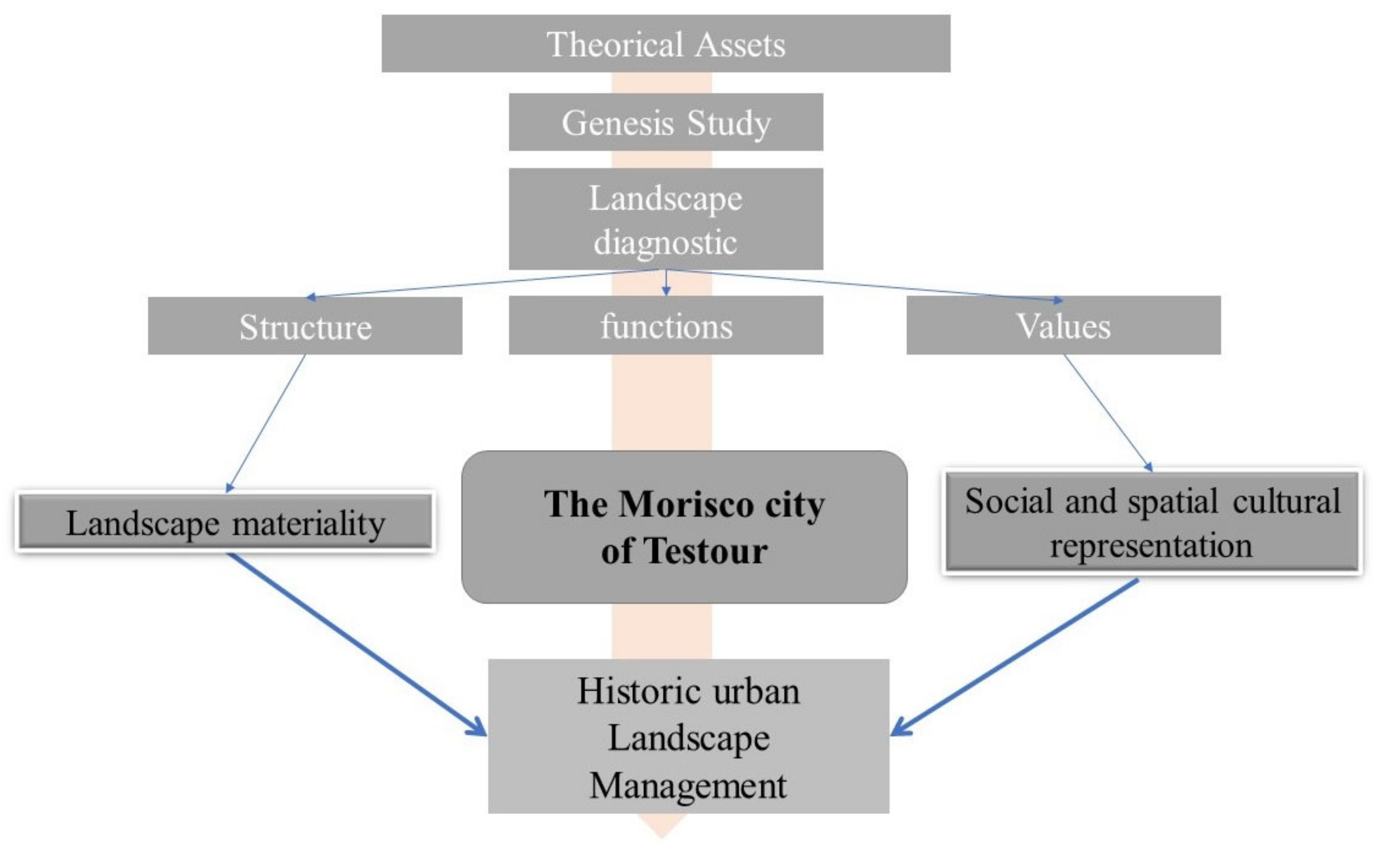
We expose this set of analytical methods, through which we trace and highlight a dynamic of these authentic landscapes that the city of Testour presents. For this purpose, the exposition of a geographical research method developed at the very beginning of our study, consisting of the spatialization of the case study in its territory based on geographical data, is indispensable. The approach presented here is distinguished by the development of a multi-scale landscape analysis method based on the concept of Genius loci. This notion was studied above all by Christian Norberg-Schulz, who describes the Genius loci with these words: “This spirit gives life to peoples and places. It accompanies them from birth to death and determines their character or essence” [
44]. The reason for this methodological path is to determine the genesis of the historic urban landscape of Testour. Firstly, to discern the genetic codes of the territory of Testour, we start with the help of personal observations of existing and old maps, a historical overview of the transformations that the city underwent. This evokes the urban genesis of the city. We intend to discern the urban and demographic evolution of the city. To do this, we proceed to a referential and critical reading of the old and current cartography, satellite images, as well as the data of the National Institute of Statistics (Tunisia). It should be noted that the last census carried out in the Tunisian Republic dates from 2014. This research step is based on Ahmed Saadaoui’s work and texts, [
17], historical texts by Ahmed Hamrouni [
16], Goethe-Institut texts [
21], and maps from Tunisia’s office of topography and cartography, as well as cartography from the Archaeological Atlas of Tunisia.
To discern the assets of the identified landscapes, we proceed with a landscape diagnostic method. Our study is also based on the analysis of a multitude of geographical maps (topographical map, soil map, hydrographic map, major state map, Atlas, etc.) and on data from the INS, to determine the structural characteristics of the study site. A form and function study as well as a diachronic analysis is essential. This method calls for a confrontation of the determinants of the landscape with a contemporary territorial articulation while proposing a hypothesis that it is not only a question of historical monument preservation but also of landscape resource that contributes to sustainable local development. We proceed then to a synthetic approach by tracing the stakes of the sites and the indicators of recognition and valorization, then to a requalification and configuration of articulation with the territory. This part of our research is based on qualitative data analysis; the literature review covers the urban heritage and the festivals with cultural heritage. Additionally, this research focuses on the most significant urban and architectural features of Testour’s souk, where festivals take place. The intangible heritage of Testour is of major interest to the town. Our aim is to identify at which points the tangible and intangible heritage of the city can be catalysts for a sustainable management approach to heritage practices in Testour. To discern the indicators of these values that the city presents, it was judicious to start this analysis of sociological survey with the inhabitants and visitors of Testour, during the festival of the grenadiers season. We propose in this part to analyze questionnaires carried out in situ on 13 and 14 October 2022.
The questionnaires took place in the souk section of the city of Testour. The following questions were asked during the interviews:
Q1—Is the festival an attraction for the city and the souk section, and how important is it to the livelihood of the local community?
Q2—What are the needs of residents and users on the street?
Q3—What is the vision of the respondents regarding heritage buildings and their perception of the importance of preserving them?
The main research methodology is demonstrated in
Figure 1:
Case Study: Testour
Testour, like many other small Tunisian cities, suffers from serious problems due to a fragmented and dysfunctional urban structure that affects its management. Studies related to the city of Testour have explored the transformations of the city’s peri-urban landscape and found an associated distinct spatial organization [
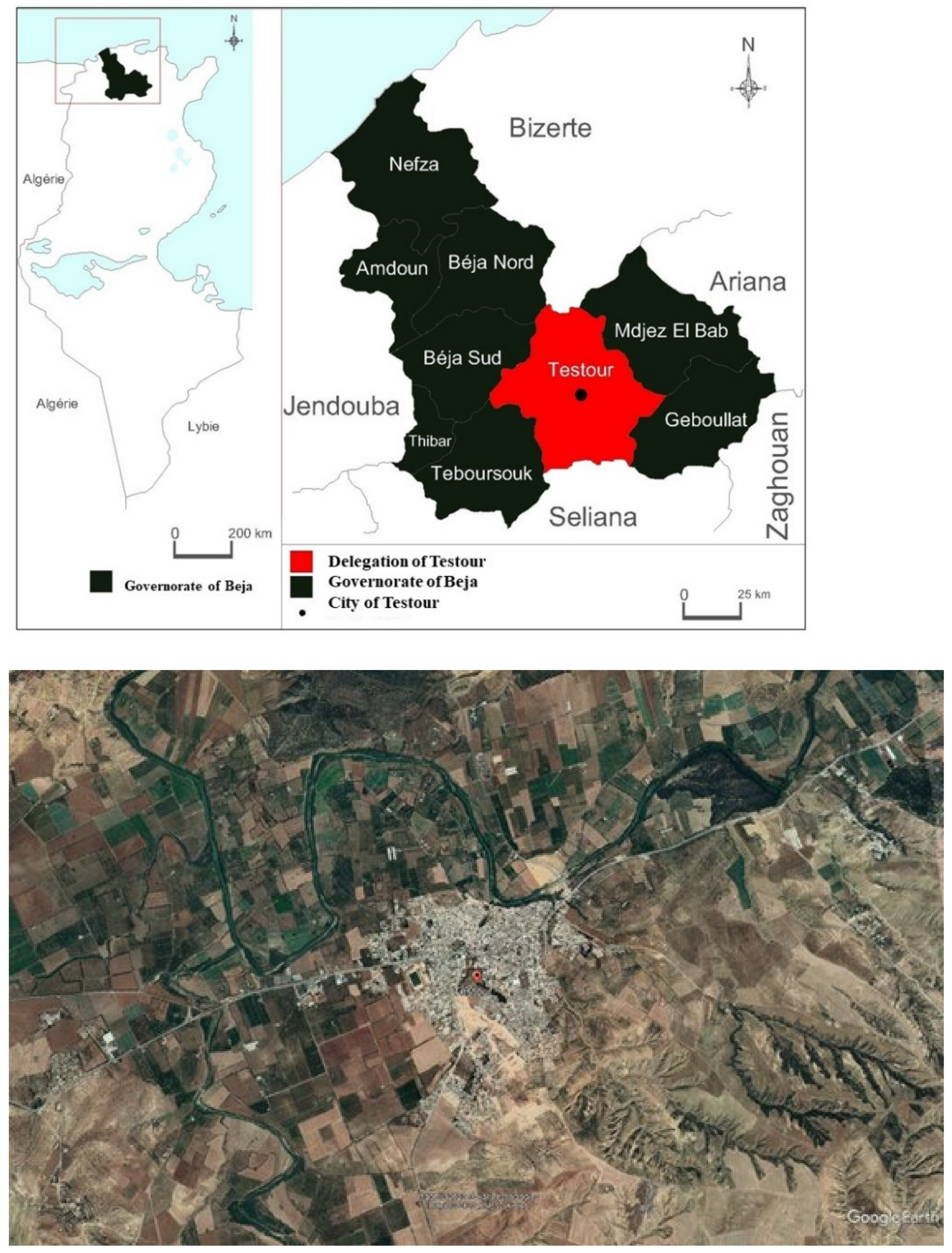
22]. The delegation is situated in the Béja governorate, in the northwest of Tunisia. It is bound on the eastern border by the delegations of Medjez El Bab and Gobelat, on the southern border by the Seliana governorate, on the western border by the Téboursouk and Béja sud delegations, and on the northern border by the Bizerte governorate (
Figure 2). The city of Testour serves as the delegation’s administrative centre. The delegation is dispersed across several additional regions, including Ibn Zaydoun, Cité 26 Fevrier, Mzougha, Zeldou, Aouled Slama, Ain Younes, Eskhira, Oued Ezarga, Sidi Abdel Aziz, and Sidi Ameur, in addition to Slouguia, which is the delegation’s second-largest city. Established in the valley of Medjerda, it dominates a vast agricultural plain. The city is located 79 km west of Tunis.
4. Results
4.1. Testour’s Landscape Ages
According to research on ancient iconography, Testour was formerly an Amazigh site called Tikila or Tichella, which means “the green grass”. Charles Tissot explains that Tichilla comes from Berber, meaning “the fertile one” [
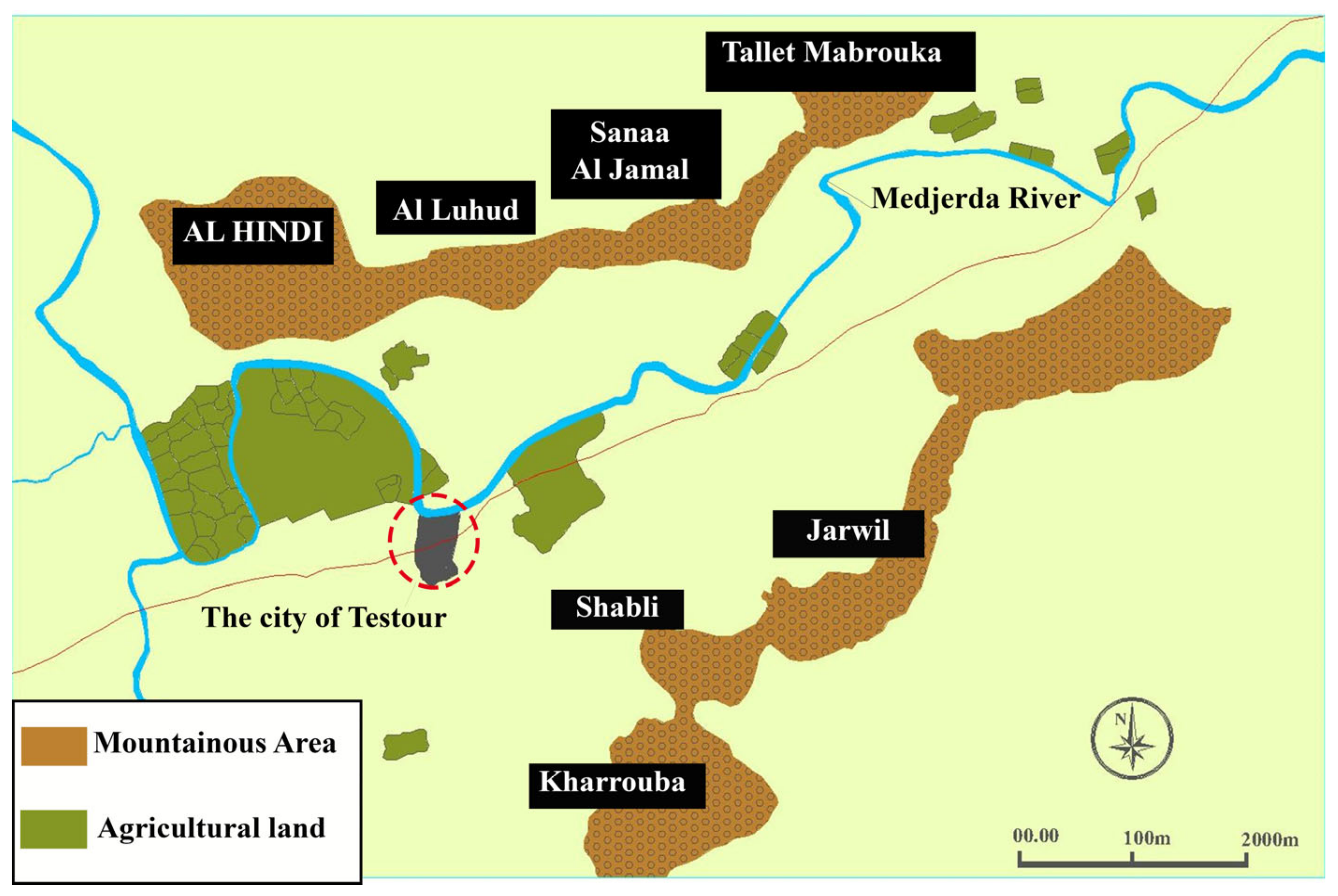
45]. However, it was given the name Testour with the arrival and installation of the Moors. According to Francisco ** for. The mountain barrier also plays a vital role in protecting the city from the prevailing winds. The city is located on the right bank of the wadi, and is protected on its right by the Djebel Kharruba and on the left side of the wadi by the Jebel Al Hindi. The nature of the soil in Testour varies according to the topographical situation. The lands located at 6 m above the main riverbed are formed in alluvium, which is essentially sandy, humid, and quite deep; these areas are privileged for market gardening and shrubbery. The lands located about 13 m above the river bed are drier and suitable for rustic arboriculture, olive and almond trees, as well as for pastoral plantations. The positioning of the land and the city in relation to the topography can be seen in
Figure 4.
The urban fabric of the city traces some of its evolution over time, the origins of the urban stratifications and their genetic codes. The historical evolution of the city shows the different origins of the existing Muslim (Andalusian and Oueslet) and Jewish populations as well as the socio-economic reasons for their settlement. The second part consists of pre-sending the urban and architectural framework of the site. We will therefore detail its urban components and analyze its structure and morphology.
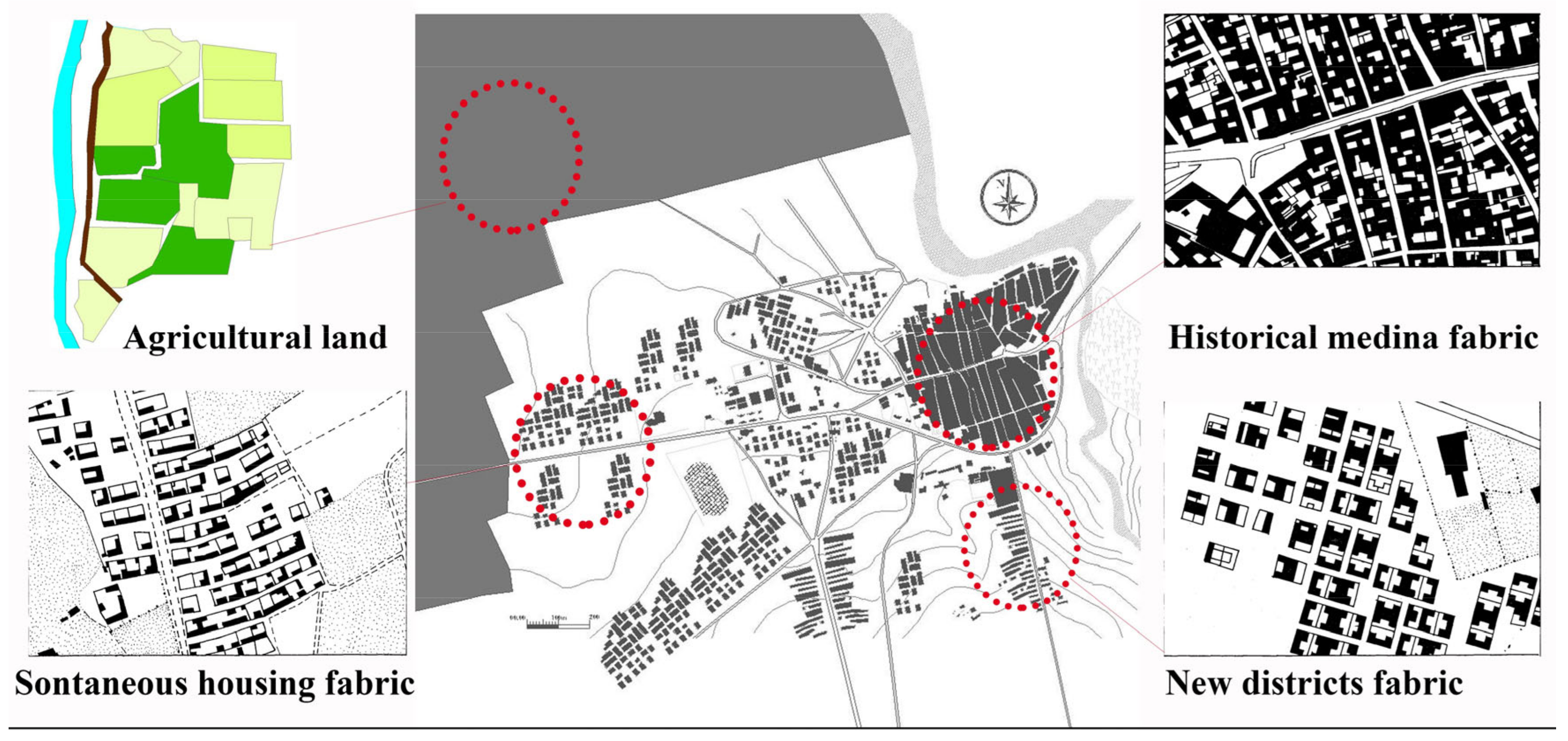
Figure 6 shows that the city of Testour and its peripheral zone present four types of structural organization:
The Moorish medina, or the old historical center: The historic fabric is grouped, introverted and dense. It has an urban character despite the agrarian structure. The mesh that characterizes the layout of the city is regular, quasi-orthogonal, pierced by wide streets with residents and service blocks in regular form according to a hierarchical distribution. The plan indicates the presence of three distinct blocks (the Andalusian district, the Tagharine district and the Jewish Hara) delimited by three longitudinal arteries of a relatively large width, connected by less wide side streets perpendicular to each other.
The new cities: the whole of this fabric is developed especially in the northwestern periphery of the city, along the road of the Kef. Several housing estates have been created by the municipality and especially by the SNIT as part of a supposed housing improvement policy. It is therefore a real city of resettlement, and is used to house either the former inhabitants of spontaneous neighborhoods or newcomers to the region.
Spontaneous settlements: these settlements do not have any premeditated structure or integrated urbanization features. The level of service and equipment is very basic, and there are few activities. These neighborhoods are experiencing building transformations that come from the fact that each user intervenes to improve his housing according to his own needs.
Testour’s old agricultural lands: The agrarian morphological structure of these former orchard of El Romèn and El Bragiil is characterized by fields blocked in small plots, whose small and medium property and agriculture are traditionally devoted to intensive vegetable and tree cultivation, mainly corresponding to an agrarian system of the enclosure. These are most often irrigated garden crops and are closely linked to the city, providing the bulk of food for daily consumption [
22].
4.2.2. Functional Parameters
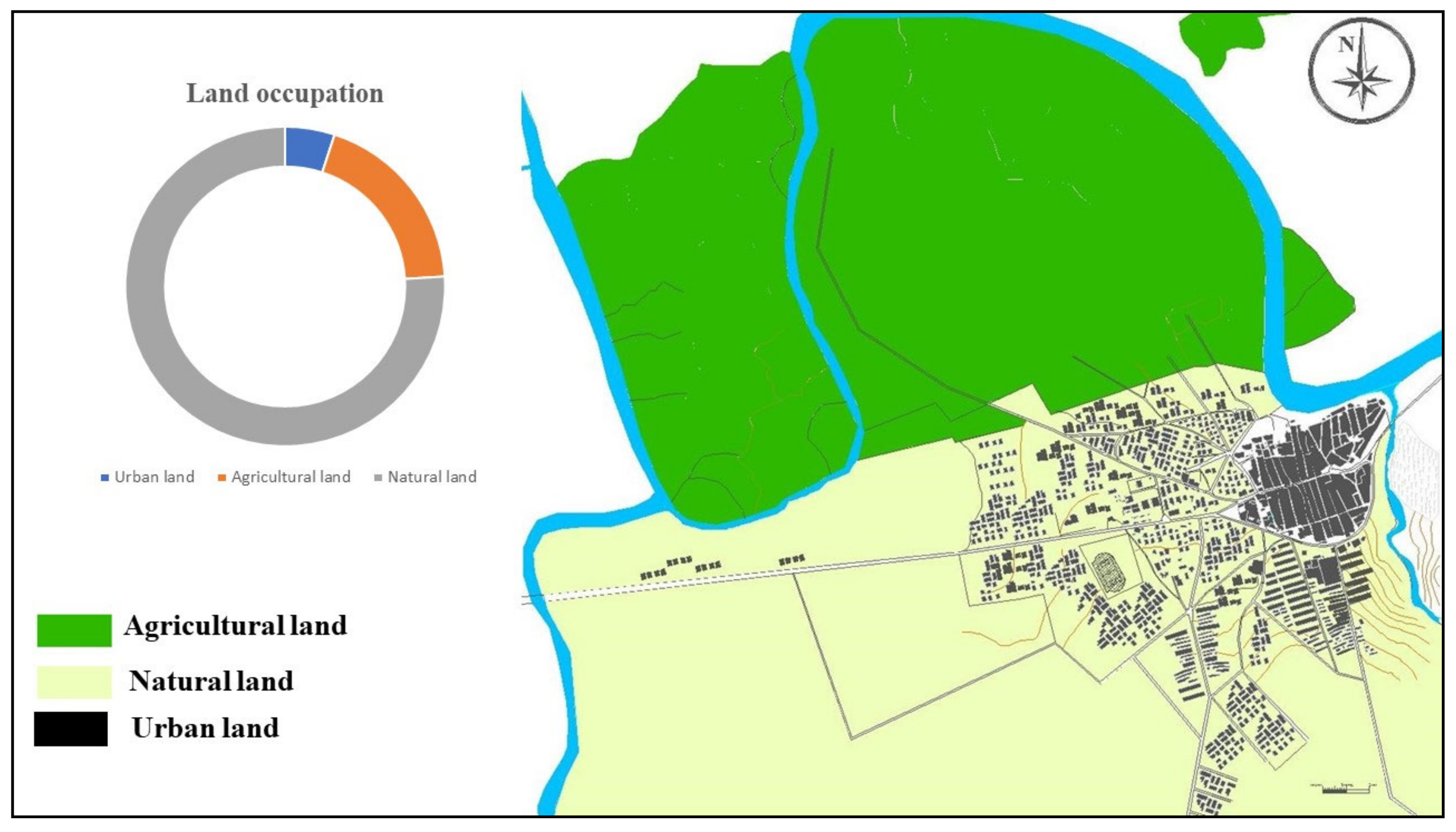
Highlighting the respective allocations to urban and agrarian parcels shows the large proportion of agricultural surfaces. Cross-referencing the land-use map of 2018 allowed us to make a schematization of land use of Testour (
Figure 7). The analysis of this map as well as the results of analysis shows that 163.58 ha presents the urban soil, the agricultural soil presents a total surface of 2364 ha and the natural soil present 578.2 ha. The value of the urban soil has almost tripled over 30 years, going from 55.87 ha in 1988 to 163.58 ha in 2018.
The study of INS statistics as well as land-use maps shows that the city’s main function is linked to its fertile environment; however, the city remains poly-functional and lives off several sectors of activity that contribute to balancing its local and regional economy: Agriculture and livestock (The main part of the agriculture was based on three types of crops), market gardening (carrots, turnips, radishes, fruit and trees, planted in the potagers, intended for the current and immediate consumption of the inhabitants), industrial crops (saffron, mulberry, intended to be sold in Tunis), and dry crops (olive trees and cereal crops). The working surface is about 38,000 ha and the exploitation of agricultural lands is 37,590 ha, whereas the surface of irrigated lands represents 1320 ha.
Animal husbandry is an auxiliary activity associated with agriculture. These are small herds of goats and sheep that are sold at the weekly market of Testour. This market of average size was one of the most important in northern Tunisia until the end of the 19th century. Chickens and rabbits are often raised in house patios.
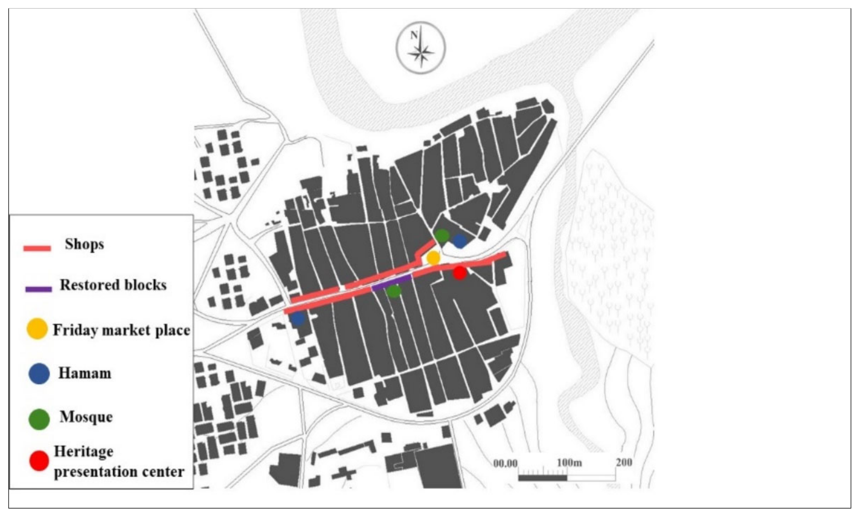
The study of Testour’s urban functionality highlights the importance of the residential function in the first instance. The number of households amounts to 8291 households, i.e., 4.05 persons/household. The number of dwellings is equal to 9384 units, or 0.88 households per dwelling. The old town center, at the heart of urban life, has three relatively wide longitudinal arteries, connected in an orthogonal manner by narrower side streets, delimiting stacked blocks. The main roads include the souk. The souk of Testour has a median road (east–west) with commercial and artisanal activities. It is the main axis of the medina, separating the Hara district from the Andalusian and the Tagarin districts. It also hosts the merchants and traders of a weekly Friday market. Most of the stores appear closely linked to the main religious buildings. The souk of Testour probably dates from the first half of the 17th century. The souk is almost exclusively occupied by stores.
Figure 8 shows that no dwelling house comes between the shops. It includes, however, some public buildings, including mosques. Another striking fact about the souk of Testour is the absence of specialization, which is unlike the Tunisian medinas. The city has nevertheless preserved an important commercial activity. Trade, services, and commercial equipment present Testour’s most important activities and are characterized by a recovery minimally satisfied. Trade is spread over the main arteries of the city with a large concentration on the longitudinal axis of the medina, which is only the souk (
Figure 8). It includes small shops and basic services. Trade in the city of Testour used to be based mainly on crafts. The secondary longitudinal streets are not as lively as the main artery. The transversal lanes are secondary routes with a private character. They open onto the surrounding valley of the medina. The hierarchy of lanes highlights the social practice in Testour in relation to the distribution of daily, weekly, or exceptional activities. A wide road is a road of exchange, whereas a narrow road is a privatized road, experienced as a dead end, although it does not present the configuration of a real dead end.
Testour is endowed with different types of social and collective facilities, including school and health facilities. It has also established some cultural facilities: 20.04% of the local population work in the administrative services and education sector. The building and construction sector accounts for 14.57% of the active workforce. The main industrial activity is the manufacture of pottery and building materials: tiles, brickworks, glazed earthenware, millwork, and ironwork. The city does not have an industrial zone, but it includes 45 companies and four exporting units. Tourist activity is non-existent in Testour. The town has only one hotel unit with a low capacity.
4.2.3. Parameters of the Values: From Requalification to Inclusive Landscape Enhancement
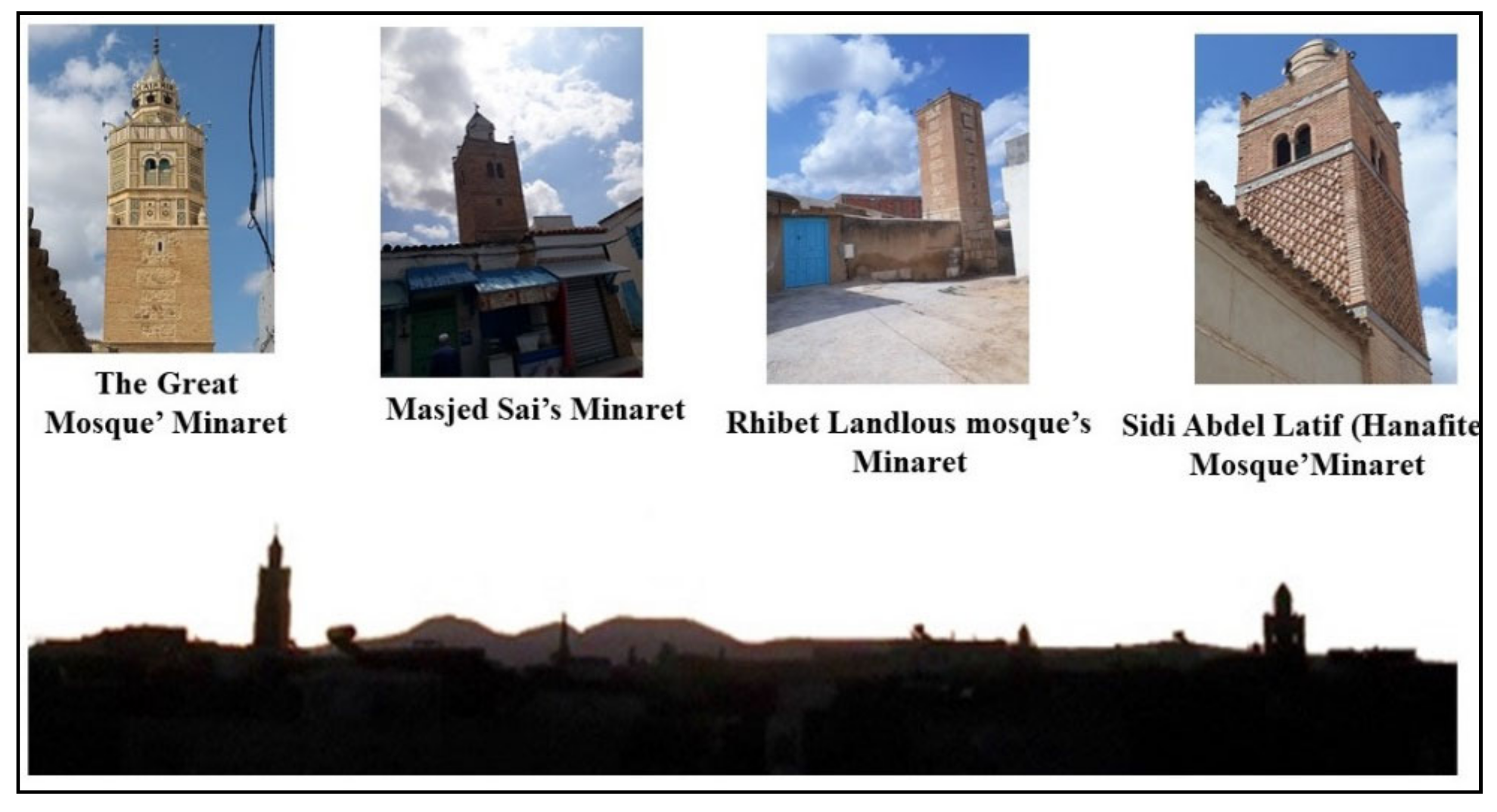
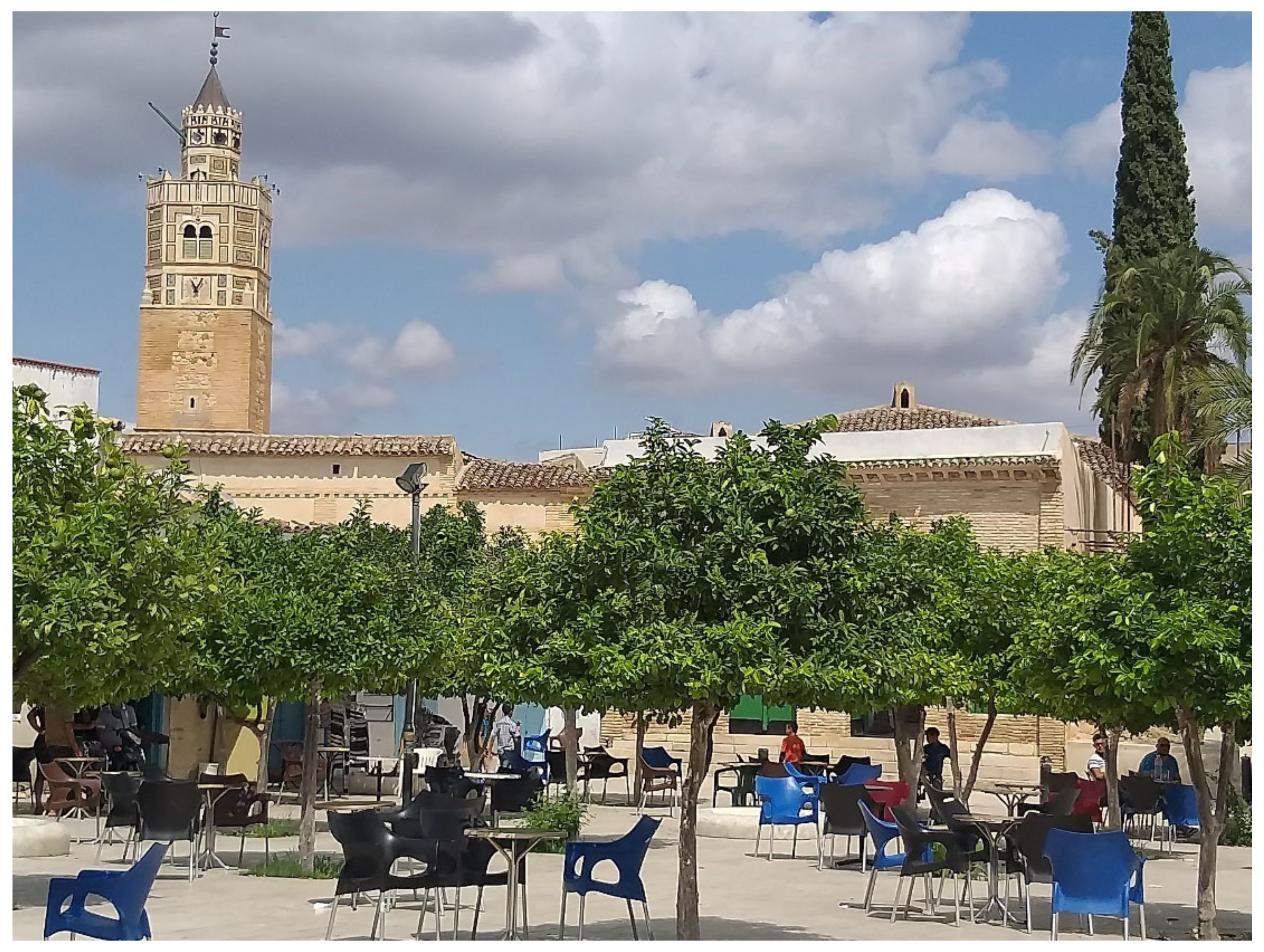
In this section, we are interested in discerning whether the transformation of Testour’s urban landscape, through the production of a new territory and the intensification of ordinary landscapes, can work for an environmental living quality. First, a visual tracing method was used. Through the study of urban and architectural landscape views from the surroundings of Testour, the dominant silhouette of the city is highlighted. On a global scale, these visual sequences represents “the skyline” that can be translated into a silhouette of a historical shape in its own environment. The different views of the city’s silhouette make it possible to grasp the phenomena of implantation and integration of the buildings and to compare their typological specificity with the topography in order to link all this to the general aspect of the site. The interpretation of the city’s skyline reveals an articulation between the background mountains and the minarets’ skyline. The city’s skyline can be seen as evidence of Moorish Tunisian architectural and urban language. A multitude of mosques can be distinguished in the urban landscape of Testour. Different architectural typologies can be discerned through the mosques (Rhiba al Andalous, Great Mosque, Sidi Abdullatif Mosque, Masjid Sây Mosque) and their different minarets imply differentiation between architectural styles: Kairouan style, Hispano-Moresque style and Mudejar style. The skyline of the city transmits a spiritual value, as it is demonstrated by
Figure 9.
Secondly, a strategy of listing and auditing landmark monuments, construction techniques, has been undertaken. The city has a very important Moorish legacy. A series of heritage elements remain today in Testour, the most remarkable village in the whole area for its cultural and agricultural heritage, with its traditional center and surrounding landscape as a unique example of urbanization, architectural vocabulary, and special typologies among all the other Moorish canters. Elements of great historical importance and identity for the population could become an engine of local development and cooperative governance through proper management of its heritage, as well as tourist, cultural, and economic exploitation.
Figure 10 presents one of the most important urban and architectural components of the city: the public place and the Great Mosque.
The intangible heritage of Testour is of major interest to the city. Our goal in this phase of the research is to pinpoint the locations where Testour’s tangible and intangible legacy might serve as catalysts for a sustainable management strategy for its heritage practices. It was wise to start this analysis with a sociological survey of Testour’s residents and visitors during the festival of the grenadiers. We propose in this section to analyze questionnaires administered on the spot to 75 participants for the city of Testour, which included 48 men and 27 women between the ages of 20 and 60.
Table 4 presents general information on the interviewees.
In response to question one, 35 out of 40 agreed that it is important to save the festival.
Thirteen stated that the festival is not essential, and three people refrained from expressing an opinion. Those who supported the preservation of the festival considered it a heritage form essential for the inhabitants of the city, and even evoked the importance of government involvement in the promotion of this kind of activity. In response to the second question, the interviewees were asked about the needs of residents and users that should be met in the street. They all agreed that facilities and services such as road paving, garbage cans, lighting units, sanitation, and routing for the movement of people during the Pomegranate Festival are a priority for development. They indicated that a plan for street design and organization of street vendors is needed. Question three deals with the vision of heritage buildings and the need to preserve them. Respondents’ views can be divided into three categories.
The first opinion of thirteen-participant sample is to support the preservation of heritage buildings in general; however, their views on these buildings differ. There is uncertainty about the preservation of heritage buildings in the Arab district due to their dilapidated condition. The second opinion, held by twenty people in the sample, is that these buildings are dilapidated, threatening their residents, and should be replaced. The third opinion, shared by seven people, varied depending on whether they saw the benefits of these buildings in terms of design, ventilation, and natural lighting. The heritage of Testour should be preserved through restitution, repair, and renovation and supported by regular maintenance.
5. Discussion
This work presents a reading grid applied to a historical site to understand, read, and interpret how urban spaces have been transformed by these actions over time. Throughout this double interaction between physical space and actors, we focus on the process of constructing a particular urban landscape and ‘sha** a place’ by the values attributed to those who conceive and transform it. By treating the historic urban landscape as a multi-scale interaction of domains, this study has adopted a new reading approach that proposes the link between time, spaces, actors, culture, and sustainability. This is done by explaining, through transdisciplinary approaches, the settlement of a Morisco society along the largest river Oued Medjerda and by tracing the state of affairs, including the mutations and transformations of the city, thereby identifying a multi-scale reading frame of reference. Thus, we highlight the propensity of the singular territory ”Testour”, while acknowleding a logic of global and holistic integration that deals with a Moorish socio-hydraulic federative territory.
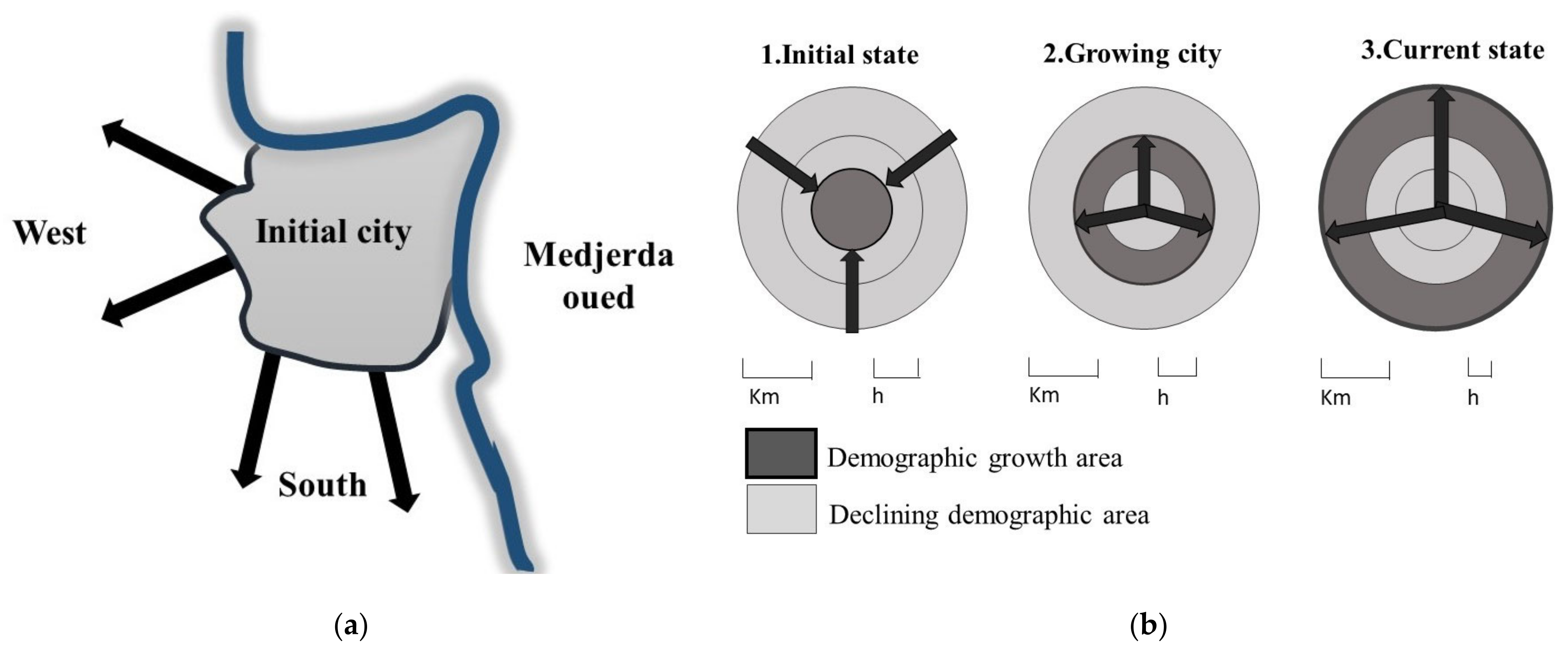
The results analysis shows that the urban and peri-urban space of Testour have been subject to many changes, both structurally and functionally. This change has been the result of the interaction between human and their spaces. This change could also be explained by the socio-spatial interaction of the population. Our study allows us to detect a discontinuous urban area spreading from the center to the agricultural periphery. We see an urban fabric develo** along the road axes and corresponding to a residential and commercial area. Moving towards the agricultural periphery, we observe scattered dwellings on the agricultural space, causing plots fragmentation, and a loss of agricultural land [
23]. This urbanization is supported by a favorable topography (a slope of less than 3%). On the other hand, it is observed that the physical topographical barrier has prevented the extension of this urbanization in the eastern part. Testour is growing continuously, and at each stage of its development, the extensions are always made in the prolongation of the existing, which allows the whole town to keep a unique form. On the other hand, this evolution is bidirectional (north–south), but the direction remains limited because the city is located between two mountain ranges. This place was chosen by the Moriscos because it is protected from invasion. They were looking for a city like their original cities in Spain and at the same time a place of refuge where they could live in peace. This mountain barrier also plays an important role in protecting the city from the prevailing winds. All the same, the development on the east–west axis is much more interesting. The Medjerda wadi, Tunisia’s main permanent waterway, was a decisive factor for the Morisques in their choice of location in this geographical area of Tunisia.
The city evolves around the east–west axis towards the Kef. The city thus extends towards the west. This urban development propelled the birth of a space dedicated to intensive agriculture, with a terroir that we can describe as typical and that was created on the left and right banks of the meanders of the Medjerda. The location to the north of the Medjerda wadi and to the northwest of the agricultural land of Testour hindered its development and served as a natural barrier. With the town’s small river and Islamic cemetery on the east side, this natural barrier is favored. Urbanization is spreading towards the south, around the axis leading to Gobelat. The urban sprawl of the city is made around two main roads, which promote access to the city by the road leading from Tunis and Béja, towards the Kef, as well as the main road towards Gobelat and Seliana. Agricultural areas are experiencing changes in use due to climate change and lack of rain. Poor agricultural practices lead to soil depletion and erosion. Agricultural lands have undergone changes in the way they are occupied and used. They becomes natural spaces. We observe the abandonment of agricultural practices to make way for natural areas (pastures, wastelands, etc.). This area is implicitly outside the agricultural fold. However, some production structures specialize in irrigated and permanent crops (orchards, olive trees, vines). These cultures have been observed to concentrate in the region’s main rivers (the Mejerda and Khaled rivers) and near the cities. This strengthening movement began in 1883 when the Testour irrigation district was laid. According to Hermi Sayari et al. [
23], this is due to several factors, including abundant irrigation water, know-how, state incentives, and the arrival of large numbers of peasants from the urban bourgeoisie and horticultural villages.
It should be emphasized that the structure of the city adopts a preconceived pattern. This is emphasized by George Marcais (1973), who interprets the urban organization of the town of Testour as a foundation built on a preconceived and relatively regular plan [
17]. The layout of the main and side streets reveals an unusual symmetry. It is a checkerboard pattern. Nizar Sayari adds to this by explaining that the alleys intersect at right angles with the main streets. The absence of a labyrinth (narrow, tortuous streets, and overflowing dead ends) is an unusual phenomenon in the layout of Arab cities of this period [
1]. The city of Testour is organized according to a preconceived and relatively regular plan. Indeed, the layout of the main and lateral streets is marked by regularity and symmetry, resulting in a dense, orthogonally structured fabric. In addition, Testour’s plan structure determines a trace of elongated rectangular lines partially in the shape of a chessboard, as if it were a Renaissance reminiscence.
Almost all Morisco foundations in Tunisia are drawn according to Saadaoui [
17]. The same plan is found in Bizerte, which was not of Morisco origin, and where the urban morphology of the Andalusian district differed from that of the existing Arab medina with its Muslim urban planning model.
It should be emphasized that the town of Testour, a great agrarian town, has the beginnings of a sustainable development as a heritage site with an urban and agrarian structure and a remarkable architectural heritage in the process of reconstitution. According to the results, the structure of Testour could be the object of a certain evolution which requires an authorized and controlled intervention on its living and not frozen heritage. The attribution of identity value to Testour is not limited to its urban, agrarian or built heritage; the studies have demonstrated the importance of the non-tangible Morisco and indigenous legacy. This heritage suffers from a lack of awareness among the younger generation, who have lost the link with the tangible heritage of the street and the district. This includes festivals and the value of architecture and urban heritage. The difficult economic situation has affected the value of the festival since the 2011 revolution and the city’s shrinking commercial free market. Solutions that do not consider the economic needs of the local community will not succeed. We also monitored the urban condition of the district and its physical heritage elements in the souk area. We have already found a gap in the overall management and protection of cultural heritage in the district.
Site visits and interviews also indicate the need to design a streetscape which allows for a better walking experience. Consequently, a district management plan is necessary and must begin with the requirements of locals and tourists, and must consider their livelihoods. This identifies the key obstacle to sustainable development. As part of a transdisciplinary approach to sustainability, this holistic study highlights the characteristics and particularities of the study site, including ts ethnic and religious mix, the average poverty of its population, the non-monumental character of its built heritage, the conservation of its urban fabric, the low level of its tourist attractiveness, etc. Avoiding simplistic and reductive reasoning, linked with an interface between science and the humanities, social and natural sciences must reconsider that Testour’s attempt as a heritage territory only will not be sufficient. It is important to understand how to act for a sustainable process, so that the territory is recognized and integrated in a logic of refabricating the territory. This logic is based on the diversity of parameters, identification, structural territory, functions, and values. The present work has tried to present a re-reading of the global assets that make it particularly interesting to question the process of heritage presentation in a global approach of sustainability, and the way it may act on different actors’ relationship to the space. This work could be extended to approach other Moriscos sites in Tunisia, while integrating new parameters in this reading approach which proposes the link between time, space, actors, culture, and sustainability.


