Proceeding Paper

Practical Research on Mixed-PPGIS Promoting Public Participation in Urban Micro-Public Space Renewal †

1
College of Public Affairs, National Taipei University, Taipei 237303, Taiwan
2
School of Architecture, Huaqiao University, **amen 361021, China
*
Author to whom correspondence should be addressed.
Presented at the 3rd IEEE International Conference on Electronic Communications, Internet of Things and Big Data Conference 2023, Taichung, Taiwan, 14–16 April 2023.
Eng. Proc. 2023, 38(1), 84; https://doi.org/10.3390/engproc2023038084
Published: 20 July 2023

Abstract

:
Based on the public participation geographic information system (PPGIS), the research platform is designed to facilitate and provide a basis for public participation. The platform includes the application of three core links: information acquisition, planning participation, and decision-making participation. To solve the problems in the planning and design of the micro-public space in China’s urban and rural planning system, the renewal practice of the micro-public space in Jimei College Village, **amen, China was used as a study case to explore how the mixed-PPGIS can be applied to micro-public space renewal by promoting the realization of “public participation”. The research results show that the mixed-PPGIS is a combination of technical methods that leads to the improvement of bottom-up participatory planning. At the same time, the importance of “people” in the mixed-PPGIS construction was emphasized.

1. Introduction

A micro-space refers to a specific space available in daily life from the perspective of geography. The concept of the vest-pocket park, the neighborhood park, and the pocket park was subsequently applied to the micro-public space [1]. Marcus and Francis described humanized space in which public spaces serve users at different times, ages, and habits [2]. Definitions of an urban micro-public space vary according to its size. The scale of urban micro-public space is usually small, ranging between 300 and 5000 m2 with several types including street parks, small-sized squares, community parks, stadiums, and others. Its main function is to be present in the residents’ daily lives. Micro-public spaces with frequent use are mostly located in areas with excellent accessibility and large demands and requirements of residents [3].
Various problems exist in the planning and design, construction, use, and management of micro-public space due to the lack of responsibility of the personnel working in the current urban and rural planning system. Dong et al. described the planning and design principles of urban micro-public space as “embedding, fixing, and public participation” [3]. Comprehensive research and in-depth analysis of the major issues for micro-public space have been conducted only by a limited number of professionals. Many scholars have proposed renewed practices of micro-public spaces, combining digital participation platforms.
In the Zhonggulou District of Bei**g, China, the Zhonggulou community public participation platform was combined with WebGIS and Baidu Map for the process of the reconstruction of the district to provide interactive channels for diversified social cooperation and community participation. ** through eight PPGIS workshops. The interview was conducted with residents, merchants, enrolled students, and tourists. Meanwhile, we acquired 35 micro-public spaces which were required to be improved and transformed. In the interview, we recorded the basic situation of the micro-public spaces (area, current facilities, functions, and others) and the evaluation of the current situation. An evaluation was carried out for safety, accessibility, comfort, recognizability, and inclusiveness (Figure 1). The micro-public spaces were classified into “community-based”, “street-based”, and “public space-based” spaces based on the interview and evaluation results. As a result, special drawings using LSV were drawn (Figure 2). Public opinions were collected and sorted through the PPGIS workshop using LSV4 for research and design.
In the second stage of the research and design, the design for transforming micro-public spaces was constructed based on public demands. Interviews with government departments and relevant construction organizations were performed for a feasibility study. The project design for the first batch of nine micro-public spaces was then confirmed. The project design was conducted by university professors. The three-dimensional drawings were uploaded to LSV (Figure 3) to facilitate the public’s browsing and inquiring. Simultaneously, the evaluation of comments and the selection of plans were carried out via WeChat official accounts to promote the participation of the public. Positive responses from the community were received. In online voting at the end of five days, we received 252,238 responses.
The project was disclosed with the traditional Chinese planning process in the third stage of the research. Experts from local governments, construction organizations, industry, universities, and on-site viewers were invited to participate in the final voting. Finally, the results of the selected projects were submitted to the government department for implementation.

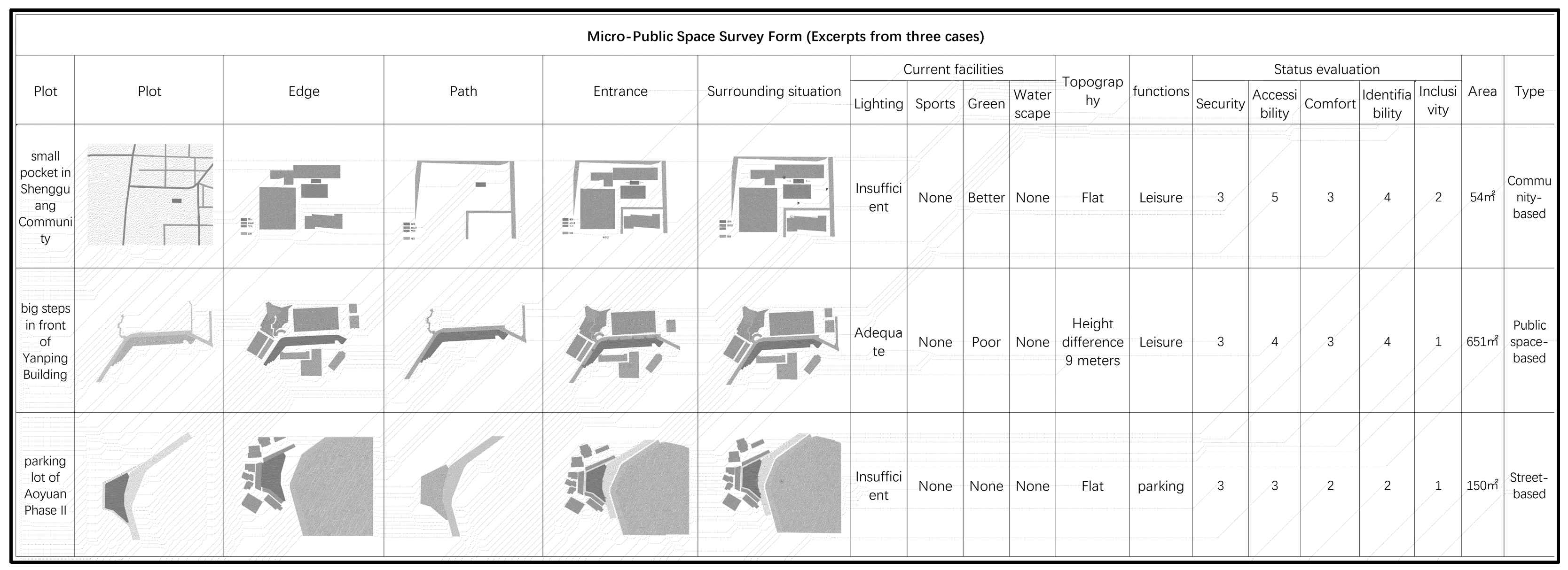
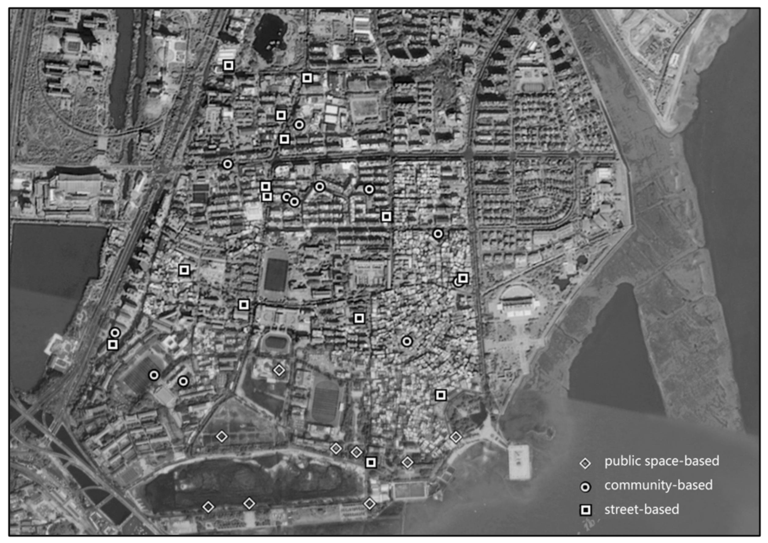
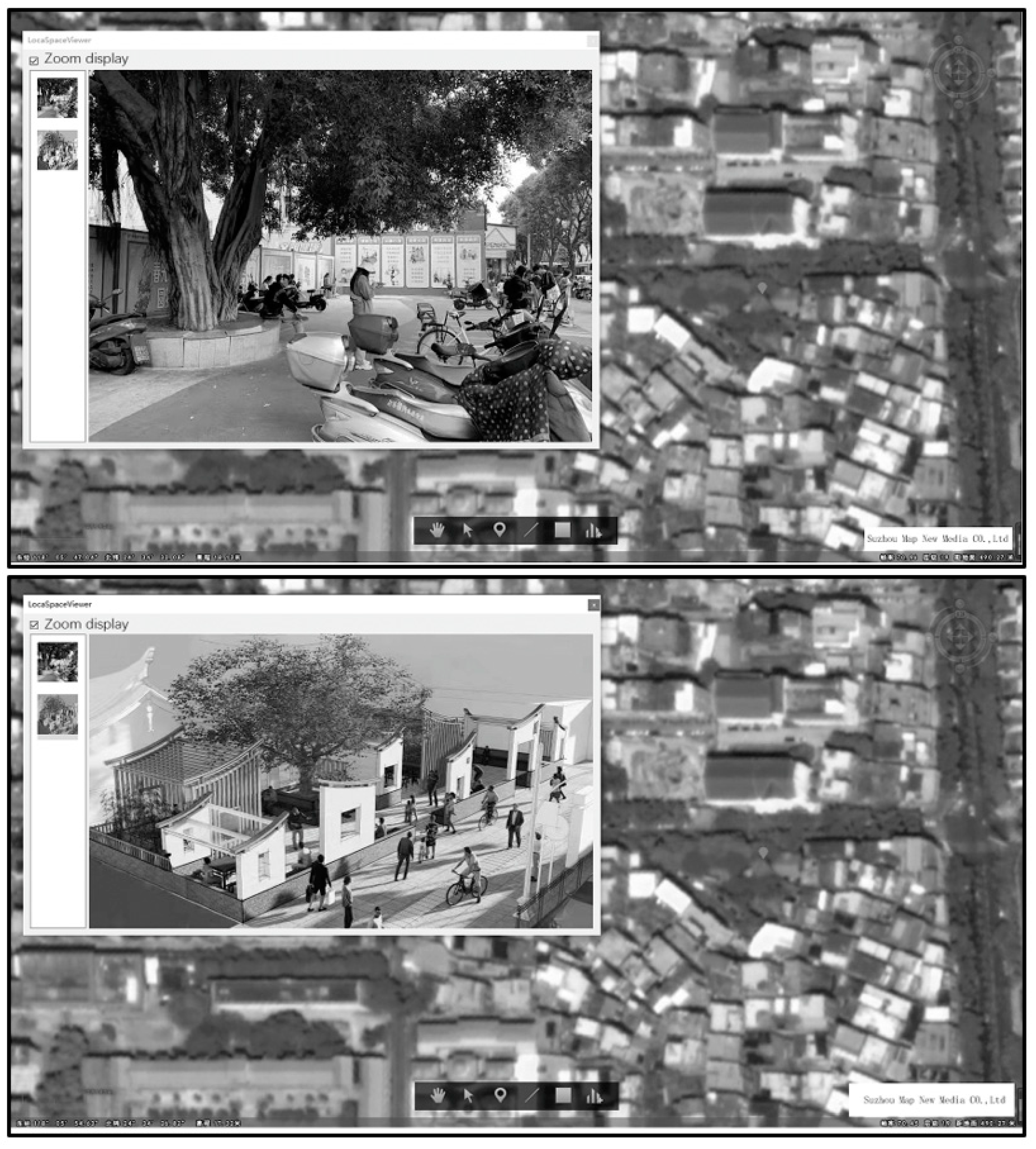
3.2. Analysis of Research Results

Mixed-PPGIS was integrated into the micro-public space renewal in the present study with public participation. Paul’s multidimensional analysis method was referred to for analyzing the planning results. Paul combined the empirical experience of the World Bank regarding community participation for the planning of urban housing, health, and agriculture sectors and proposed a multidimensional analysis framework for community participation based on the “objectives”, “intensity”, and “instruments” (Figure 4) [7]. In the micro-public space renewal of Jimei School Village, the whole process of “public participation” was realized in the mixed-PPGIS public participation platform.
  • We held several PPGIS workshops in the planning stage with LSV4 for participatory map** and information acquisition of micro-public spaces. GIS thematic map data were produced and analyzed, too. University teams, residents, and tourists participated in information sharing and decisions through agreement, cooperation, and interaction. The planning results were visualized in an LSV thematic map to encourage public participation through WeChat. Other than the participants, administrative workers and experts were also involved. Participation became more active in the negotiation stage, and the goal of the renewal was achieved through understanding and agreement. The final projects were selected via voting through a WeChat public platform. The public’s opinion was shared with experts and government workers. With such participation, the objectives of the renewal were achieved based on the consensus reached in planning and decision making.
Figure 4. Figure 4. Multidimensional analysis framework for community participation [7].
Engproc 38 00084 g004

4. Conclusions and Recommendations

According to the summary of the experience of 50 empirical cases in the World Bank, community participation was not successful in several projects due to technological gaps, weak promotion and supervision, lack of a set of comprehensive services, and failure to implement key policies for the project. Mixed-PPGIS allows technical methods to be integrated into bottom-up participatory planning. Three characteristics such as multiple participation, phase partitioning processing, and mixed development mode were reflected in the present study [8]. The participation platform of mixed-PPGIS played a critical role in the renewal of urban micro-public spaces with “people” as the key factor. The timely and appropriate participation of administrative staff is necessary to promote participatory planning and plays different roles in different stages of the whole micro-public space renewal process. The results show the importance of the university team which plays a role of organization and guidance in the whole process.

Author Contributions

Conceptualization, Y.H.; methodology, Y.H.; software, X.H.; validation, Y.H., Y.C.; formal analysis, Y.H.; investigation, X.H.; resources, J.Z.; data curation, Y.H.; writing—original draft preparation, X.H.; writing—review and editing, Y.H.; visualization, Y.H.; supervision, Y.H.; project administration, Y.H.; All authors have read and agreed to the published version of the manuscript.

Funding

This research was supported by “the 2021 Fujian Social Science Foundation Project”, No. FJ2021B194.

Institutional Review Board Statement

Not applicable.

Informed Consent Statement

Informed consent was obtained from all subjects involved in the study.

Data Availability Statement

The data and materials include primary data collected during the teaching practice process, including pictures and texts. The datasets used or analysed during the current study are available from the corresponding author upon reasonable request.

Conflicts of Interest

The authors declare no conflict of interest.

References

  1. Danford, R.S.; Strohbach, M.W.; Warren, P.S. Active Greening or Re-wilding the City: How does the intention behind small pockets of urban green affect use? Urban For. Urban Green. 2018, 29, 377–383. [Google Scholar] [CrossRef]
  2. Marcus, C.C.; Francis, C. People Places-Design Guidelines for Urban Open Space, 2nd ed.; John Wiley & Sons: Hoboken, NJ, USA, 1997. [Google Scholar]
  3. Xu, H.; Zhu, J.; Wang, Z.; Fang, W. Exploring the Spatial Pattern of Urban Block Development Based on POI Analysis: A Case Study in Wuhan, China. Sustainability 2019, 11, 6961. [Google Scholar] [CrossRef] [Green Version]
  4. Fei, X.; Mao, B. Study on the Strategy of Urban Small Public Space Planning Based on the Concept of Park City—Take the Old Town of Jiangling County in **gzhou as an Example. Curr. Urban Stud. 2020, 19, 107–114. [Google Scholar] [CrossRef] [Green Version]
  5. Yu, J.; Meng, Y.; Zhou, S.; Zeng, H.; Li, M.; Chen, Z.; Nie, Y. Research on Spatial Delineation Method of Urban-Rural Fringe Combining POI and Nighttime Light Data—Taking Wuhan City as an Example. Int. J. Environ. Res. Public Health 2023, 20, 4395. [Google Scholar] [CrossRef] [PubMed]
  6. Yun, J.; Yu, W.; Wang, H. Exploring the Distribution of Gardens in Suzhou City in the Qianlong Period through a Space Syntax Approach. Land 2021, 10, 659. [Google Scholar] [CrossRef]
  7. Paul, S. Community Participation in Development Projects: The World Bank Experience; World Bank: Washington, DC, USA, 1987; pp. 8–9. [Google Scholar]
  8. Kacaw, L.; Tsai, B.-W. The Application of PPGIS to Telecoupling Research: A Case Study of the Agricultural Landscape Transformation in an Indigenous Village in Taiwan. Sustainability 2023, 15, 1577. [Google Scholar] [CrossRef]
Figure 1. Micro-public space design (excerpts from three cases).
Engproc 38 00084 g001
Figure 2. Figure 2. Thematic map.
Engproc 38 00084 g002
Figure 3. Figure 3. 3D drawings based on LSV4.
Engproc 38 00084 g003
Disclaimer/Publisher’s Note: The statements, opinions and data contained in all publications are solely those of the individual author(s) and contributor(s) and not of MDPI and/or the editor(s). MDPI and/or the editor(s) disclaim responsibility for any injury to people or property resulting from any ideas, methods, instructions or products referred to in the content.

