Identifying Linear Traces of the Han Dynasty Great Wall in Dunhuang Using Gaofen-1 Satellite Remote Sensing Imagery and the Hough Transform

 ,
, 
Abstract
:
1. Introduction
1.1. Historical and Archaeological Background
2. Study Area and Data
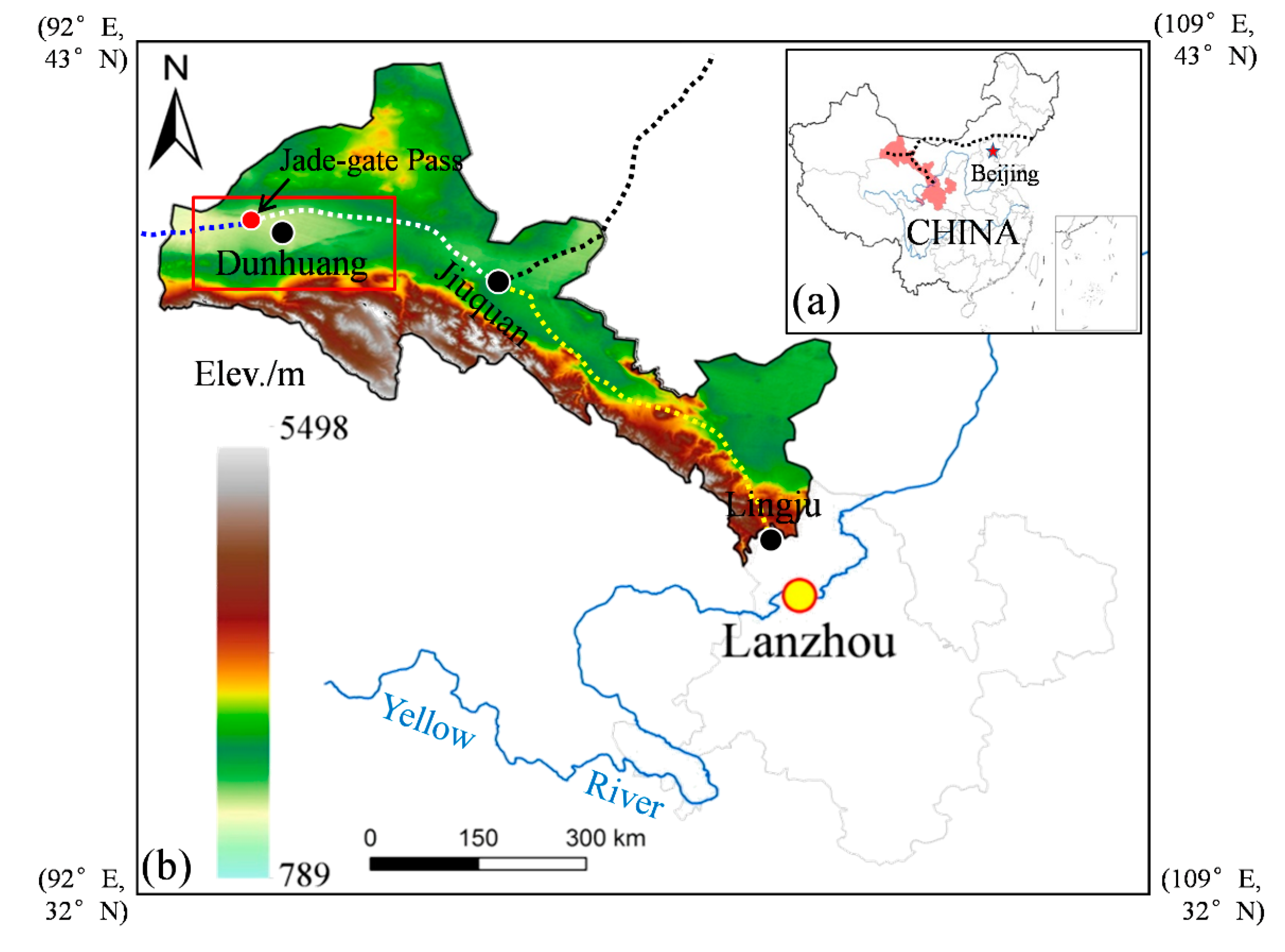
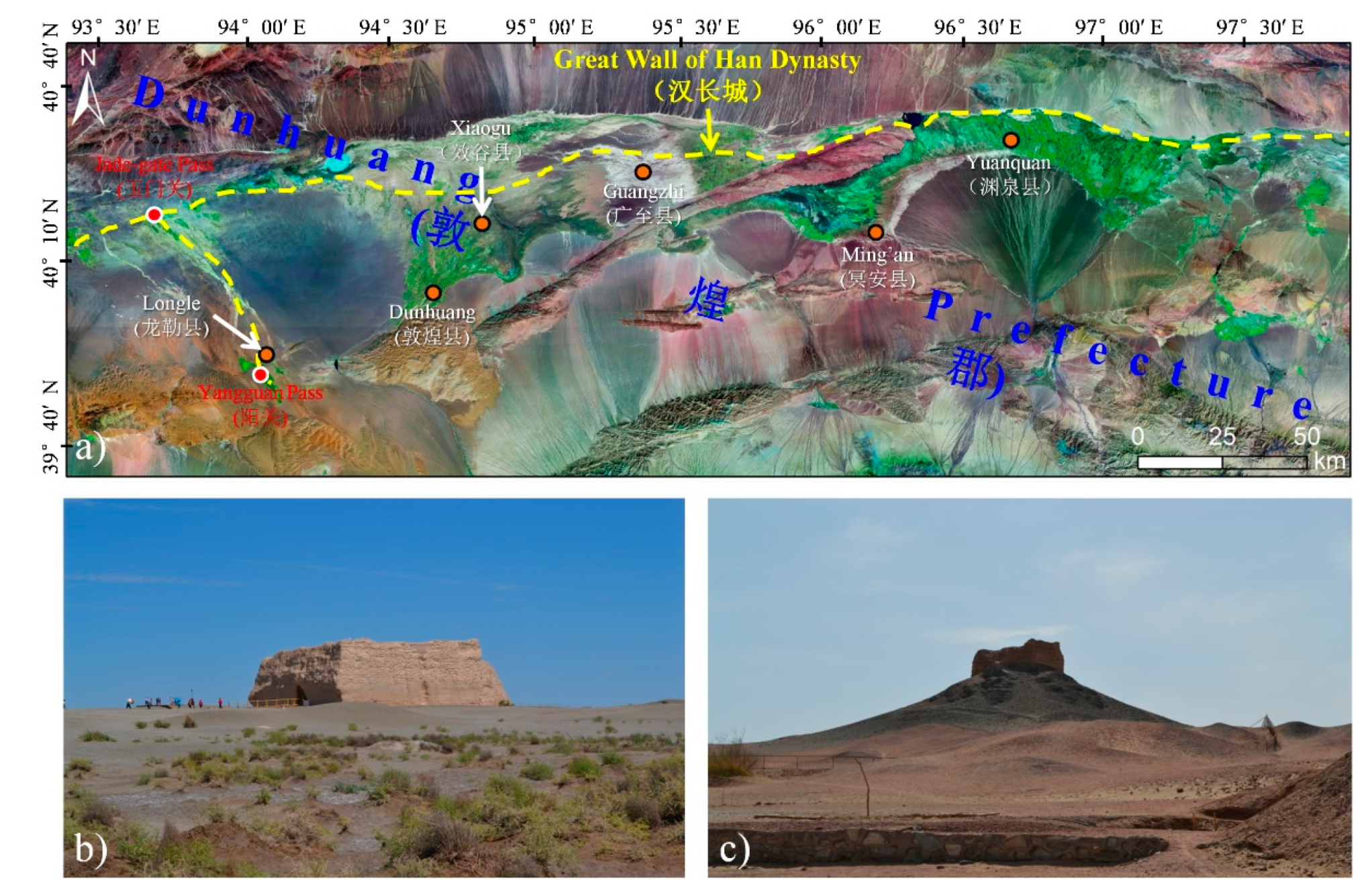
2.1. Ancient Dunhuang
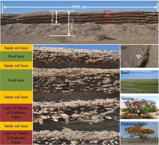
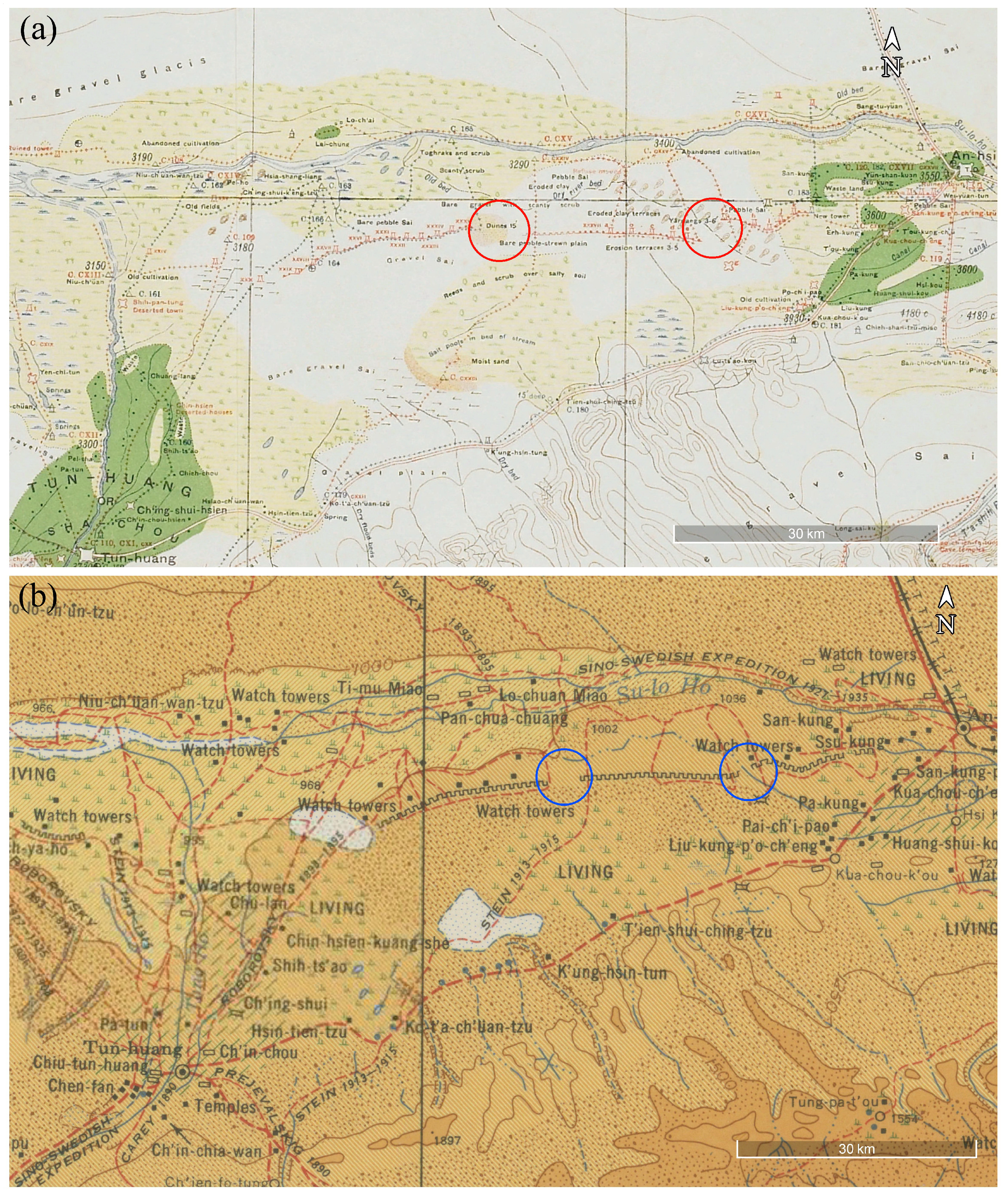
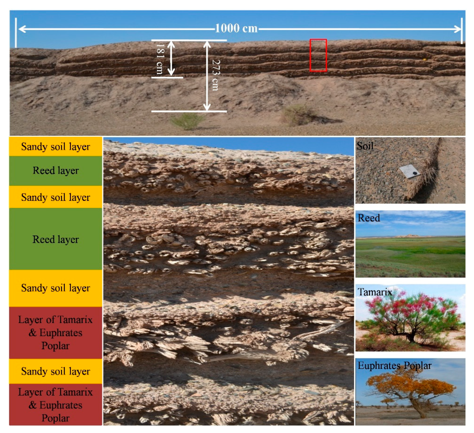
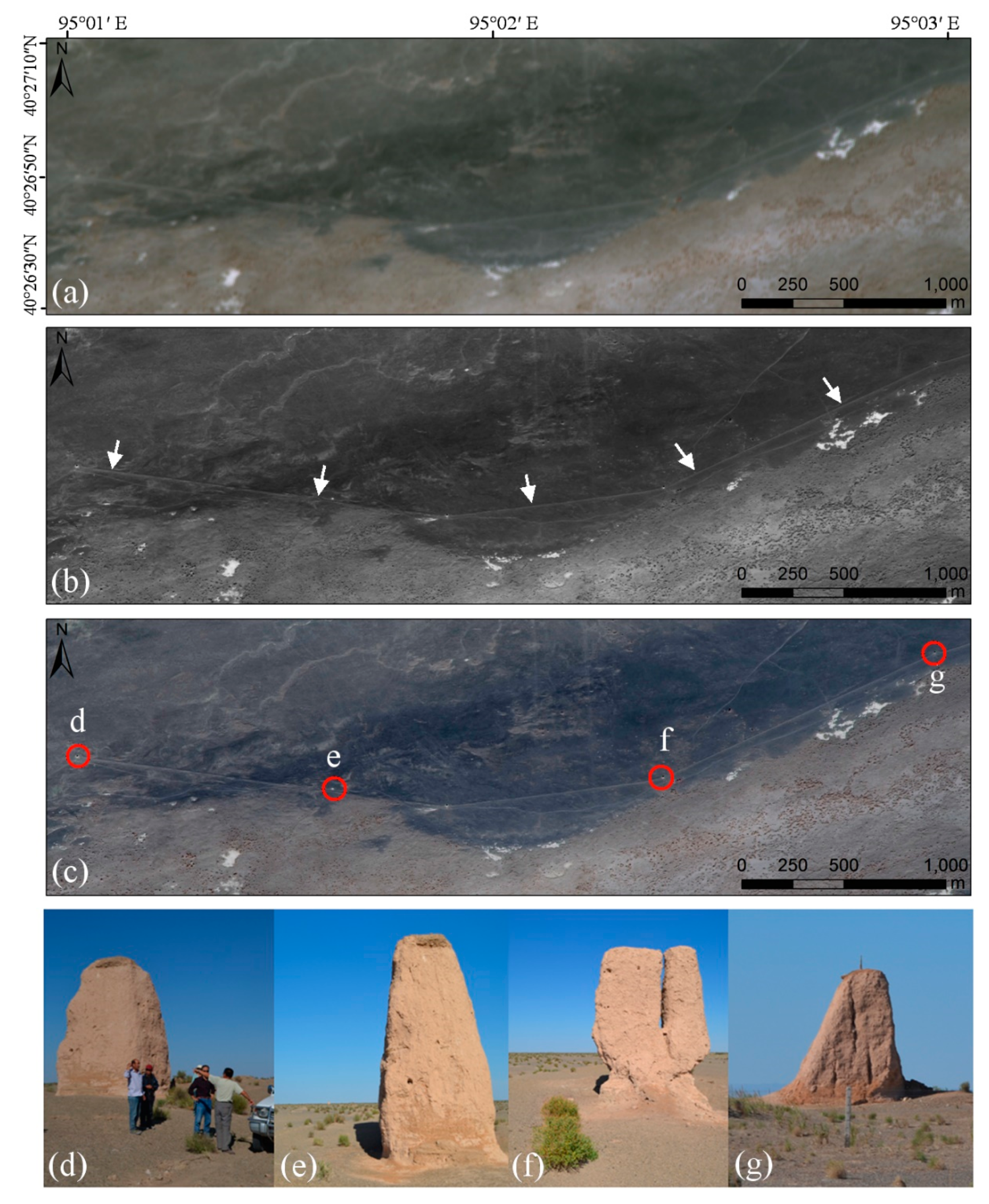
2.2. Linear Traces of GH in Dunhuang
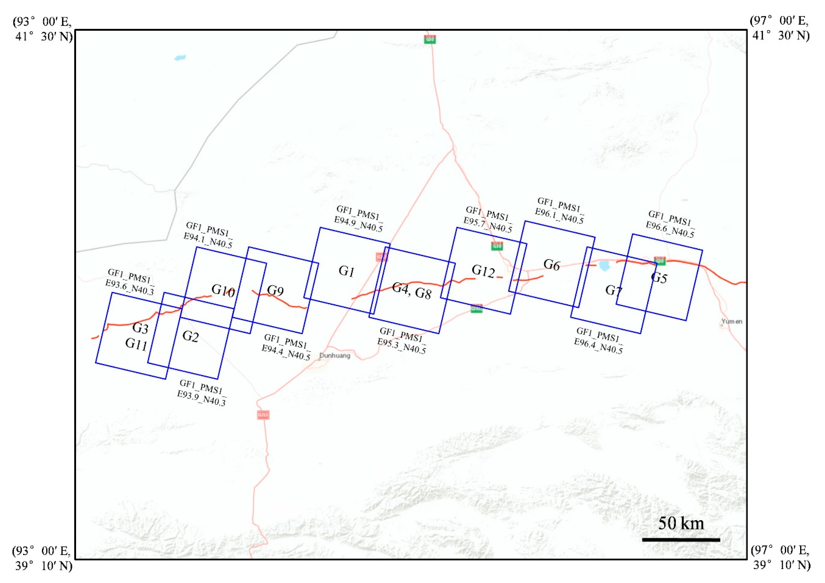
2.3. Remote Sensing Data
3. Methodology
3.1. Data Pre-Processing
3.2. M-Statistic
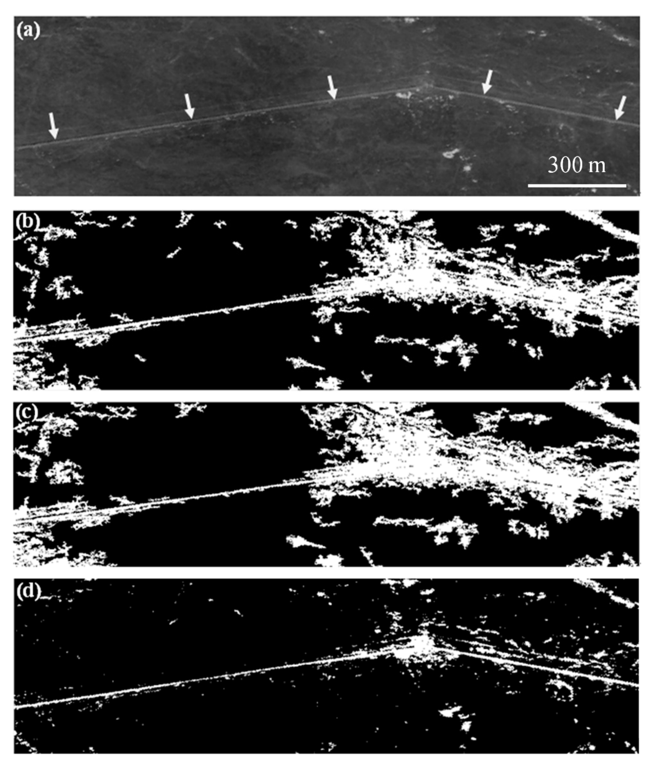
3.3. Otsu Segmentation
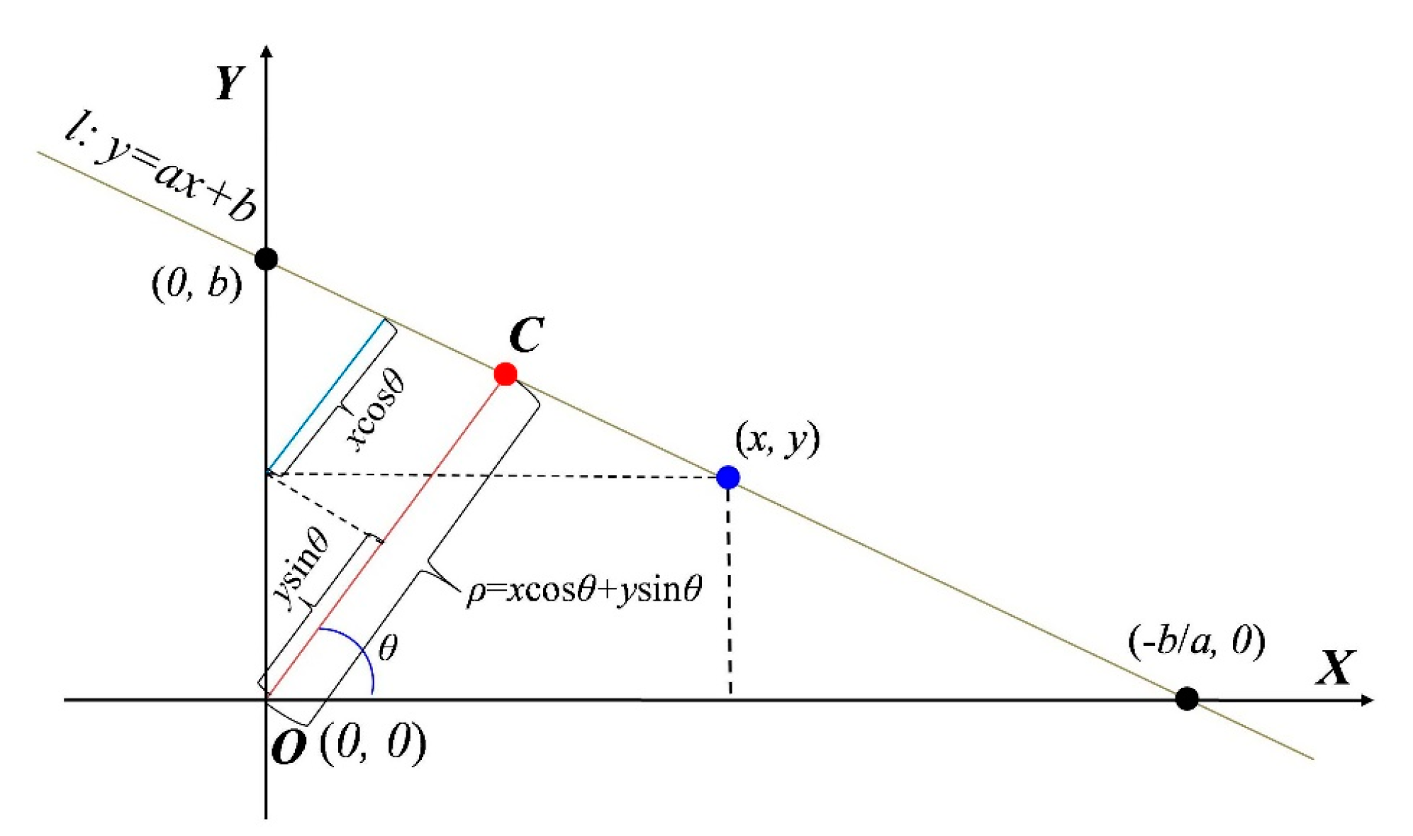
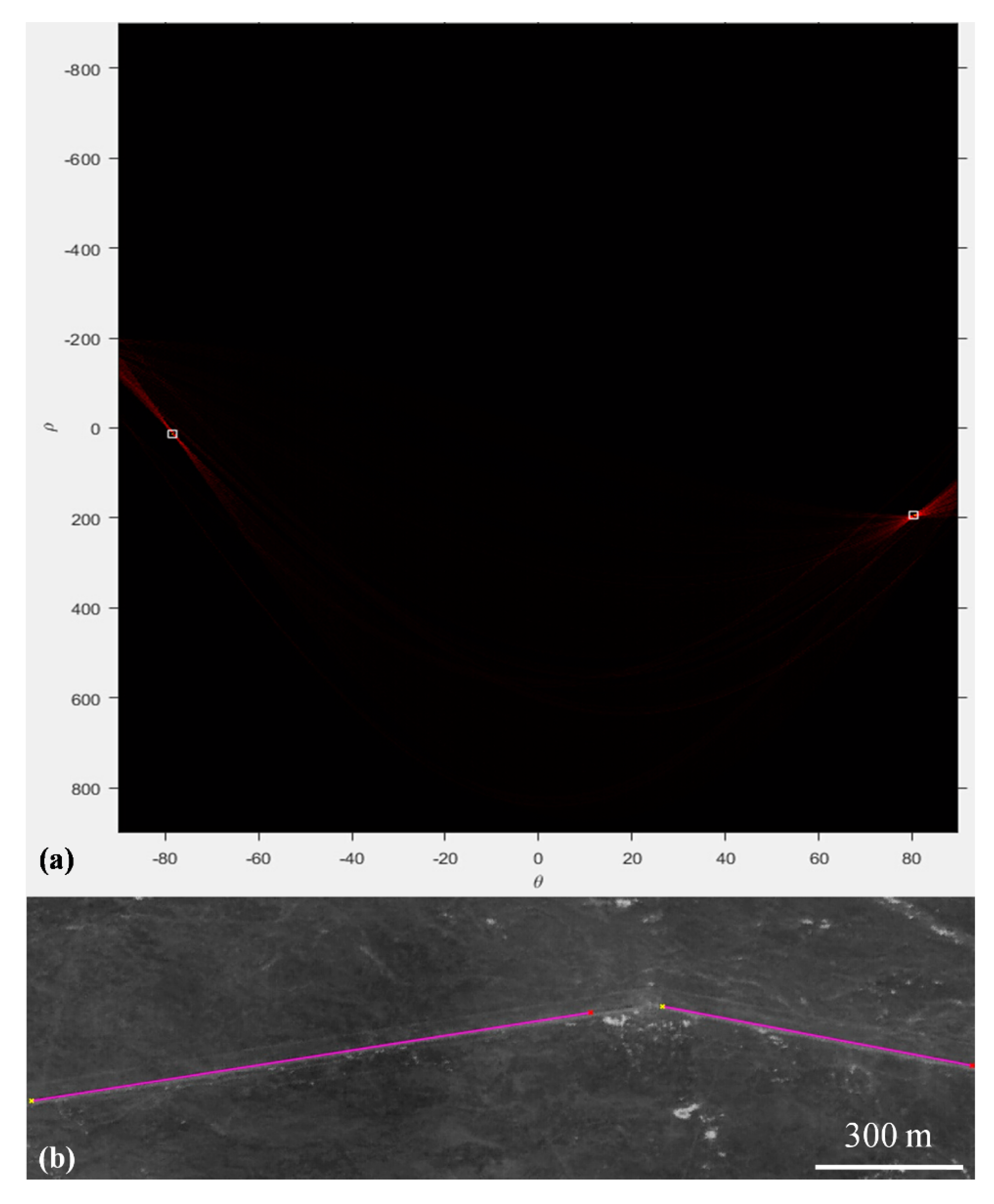
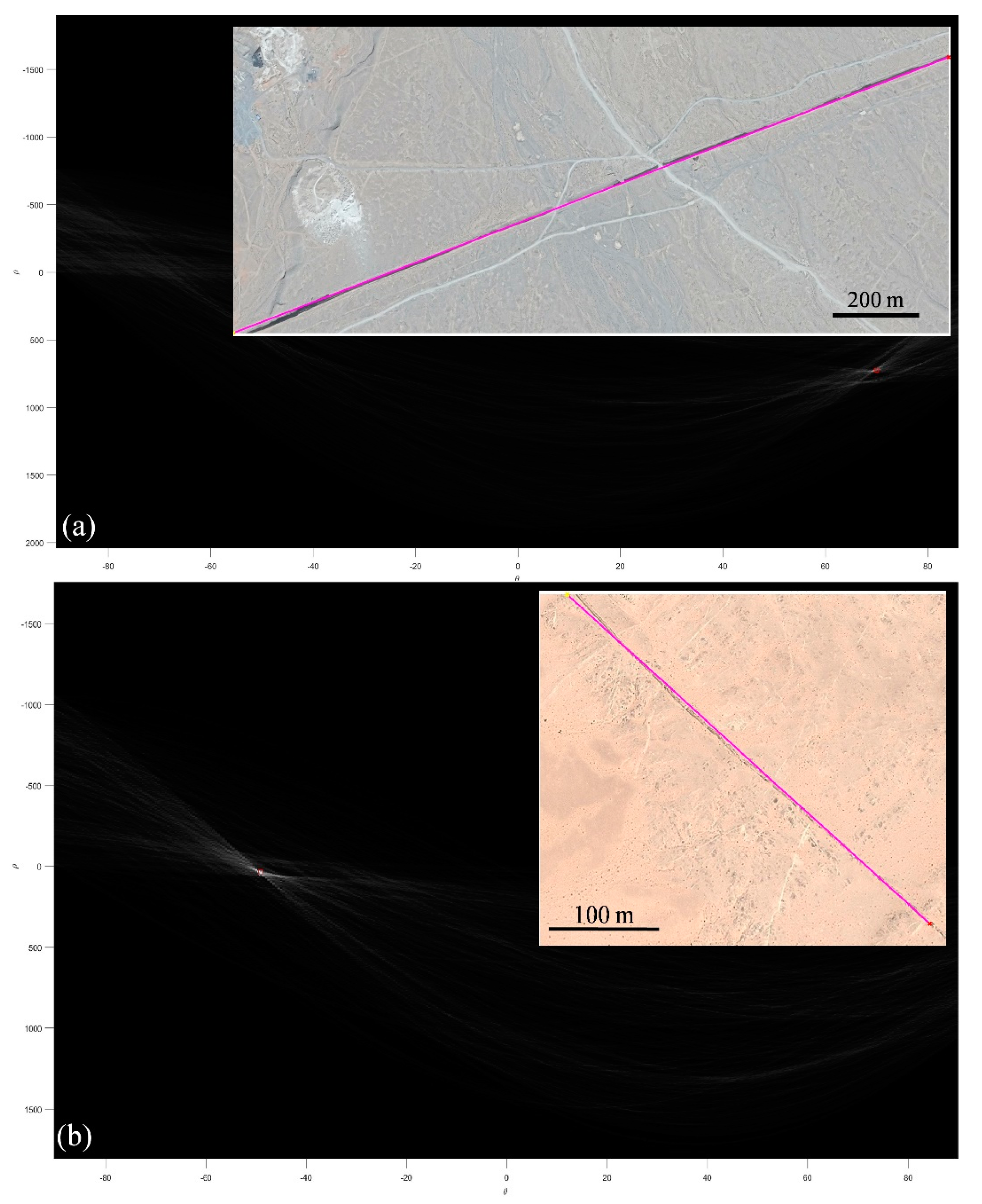
3.4. Linear Hough Transform
3.5. Ground Verification Surveys
4. Results and Discussion
4.1. M-Statistic of Linear Traces of GH
4.2. Image Segmentation
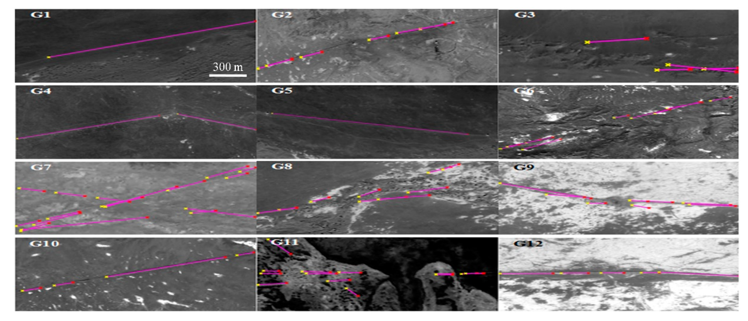
4.3. Automatic Identification of Linear Traces
4.4. Performance Evaluation
Author Contributions
Funding
Acknowledgments
Conflicts of Interest
References
- Wang, G. The Evolution of the Great Wall of China; The Commercial Press: Shanghai, China, 1928. (In Chinese) [Google Scholar]
- **g, A. The History of the Great Wall of China; Shanghai People’s Publishing House: Shanghai, China, 2006. (In Chinese) [Google Scholar]
- Waldron, A. The Great Wall of China: From History to Myth; Cambridge University Press: Cambridge, UK, 1992. [Google Scholar]
- Luo, L. Space Archaeology for Tunshu Sites along the South Route of the Ancient Silk Road. Ph.D. Thesis, University of Chinese Academy of Sciences, Bei**g, China, 2016. (In Chinese). [Google Scholar]
- Zhang, W. The Construction System of the Great Wall of China; Zhonghua Book Company: Bei**g, China, 1976. (In Chinese) [Google Scholar]
- Waltner, A. Review of Arthur Waldron, The Great Wall of China: From History to Myth. J. Orient. Stud. 1992, 19, 255–256. [Google Scholar]
- Su, H.; Qu, L.; He, K.; Zhang, Z.; Wang, J.; Chen, Z.; Gu, H. The Great Wall of China: A physical barrier to gene flow? Heredity 2003, 90, 212. [Google Scholar] [CrossRef] [PubMed]
- Lattimore, O. Origins of the Great Wall of China: A Frontier Concept in Theory and Practice. Geogr. Rev. 1937, 27, 529–549. [Google Scholar] [CrossRef]
- Sima, Q. Shiji; Zhonghua Book Company: Bei**g, China, 1962. First published 91 BC. (In Chinese) [Google Scholar]
- Ban, G. HanShu; Zhonghua Book Company: Bei**g, China, 1962. First published 92 BC. (In Chinese) [Google Scholar]
- Xu, P. The Archaeology of the Great Wall of the Qin and Han Dynasties. J. East Asian Archaeol. 2001, 3, 259–281. [Google Scholar]
- Duan, Q.; Xu, W. The Discovery and Research of the Great Wall of China; Science Press: Bei**g, China, 2014. (In Chinese) [Google Scholar]
- Stein, A. Serindia; Clarendon Press: Oxford, UK, 1921. [Google Scholar]
- Li, Z. Sites of the Great Wall and beacon towers in Dunhuang prefecture (Synopsis). Dunhuang Res. 1995, 2, 120–126. (In Chinese) [Google Scholar]
- Li, B. An oasis disappeared between Guazhou and Shazhou. Dunhuang Res. 1994, 3, 71–78. (In Chinese) [Google Scholar]
- Li, B. Yihe and Central military towns of Dunhuang prefecture in the Han Dynasty. J. Northwest Norm. Univ. (Social Sci.) 1995, 32, 93–96. (In Chinese) [Google Scholar]
- Li, B. Courier stations from Guazhou to Shazhou in the Tang Dynasty. In Historical Geography; Chen, Q., Zou, Y., Eds.; Shanghai People Press: Shanghai, China, 1996; pp. 93–101. (In Chinese) [Google Scholar]
- Li, Z. Collation and Annotation of Dunhuang Manuscripts; Gansu People Press: Lanzhou, China, 2008. (In Chinese) [Google Scholar]
- Luo, L.; Wang, X.; Liu, C.; Guo, H.; Du, X. Integrated RS, GIS and GPS Approaches to Archaeological Prospecting in the Hexi Corridor, NW China: A Case Study of the Royal Road to Ancient Dunhuang. J. Archaeol. Sci. 2014, 50, 178–190. [Google Scholar] [CrossRef]
- Huang, Y.; Xu, W. Research on the Great Wall of Han Dynasty: A review. J. Chin. Hist. Stud. 2012, 5, 40–47. (In Chinese) [Google Scholar]
- Stein, A. Innermost Asia: Detailed Report of Explorations in Central Asia, Kansu and Eastern Iran, Carried Out and Described under the Orders of H. M. Indian Government; Clarendon Press: Oxford, UK, 1928. [Google Scholar]
- Hedin, S. Scientific Results of a Journey in Central Asia 1899–1902; Lithographic Institute of the General Staff of the Swedish Army: Stockholm, Sweden, 1907. [Google Scholar]
- ** and interpretation of oblique aerial photographs. Archaeol. Prospect. 2001, 8, 13–27. [Google Scholar] [CrossRef]
- Lin, A.; Novo, A.; Har-Noy, S.; Ricklin, N.; Stamatiou, K. Combining GeoEye-1 satellite remote sensing, UAV aerial imaging, and geophysical surveys in anomaly detection applied to archaeology. IEEE J. Sel. Top. Appl. Earth Observ. Remote Sens. 2011, 4, 870–876. [Google Scholar] [CrossRef]
- Agapiou, A.; Lysandrou, V.; Lasaponara, R.; Masini, N.; Hadjimitsis, D.G. Study of the Variations of Archaeological Marks at Neolithic Site of Lucera, Italy Using High-Resolution Multispectral Datasets. Remote Sens. 2016, 8, 723. [Google Scholar] [CrossRef]
- Luo, L.; Wang, X.; Liu, J.; Zheng, W.; Zhen, J.; Zhu, L.; Liu, C.; Wan, H. Low-Cost Archaeological Investigation and Rapid Map** of Ancient Stone Tidal Weirs in the Penghu Archipelago Using Google Earth. Sustainability 2019, 11, 4536. [Google Scholar] [CrossRef]
- Cerra, D.; Agapiou, A.; Cavalli, R.M.; Sarris, A. An Objective Assessment of Hyperspectral Indicators for the Detection of Buried Archaeological Relics. Remote Sens. 2018, 10, 500. [Google Scholar] [CrossRef]
- Abate, N.; Lasaponara, R. Preventive Archaeology Based on Open Remote Sensing Data and Tools: The Cases of Sant’Arsenio (SA) and Foggia (FG), Italy. Sustainability 2019, 11, 4145. [Google Scholar] [CrossRef]
- Kalayci, T.; Lasaponara, R.; Wainwright, J.; Masini, N. Multispectral Contrast of Archaeological Features: A Quantitative Evaluation. Remote Sens. 2019, 11, 913. [Google Scholar] [CrossRef]
- Tapete, D.; Cigna, F.; Donoghue, D. ‘Looting marks’ in space-borne SAR imagery: Measuring rates of archaeological looting in Apamea (Syria) with TerraSAR-X Staring Spotlight. Remote Sens. Environ. 2016, 178, 42–58. [Google Scholar] [CrossRef]
- Tapete, D.; Cigna, F. COSMO-SkyMed SAR for Detection and Monitoring of Archaeological and Cultural Heritage Sites. Remote Sens. 2019, 11, 1326. [Google Scholar] [CrossRef]
- Zhu, X.; Chen, F.; Guo, H. Reconstruction of the Water Cultivation Paleoenvironment Dating Back to the Han and Tang Dynasties Surrounding the Yangguan Frontier Pass Using X- and L-Band SAR Data. Remote Sens. 2018, 10, 1536. [Google Scholar] [CrossRef]
- Stewart, C.; Oren, E.; Cohen-Sasson, E. Satellite remote sensing analysis of the Qasrawet archaeological site in North Sinai. Remote Sens. 2018, 10, 1090. [Google Scholar] [CrossRef]
- Masini, N.; Gizzi, F.; Biscione, M.; Fundone, V.; Sedile, M.; Sileo, M.; Pecci, A.; Lacovara, B.; Lasaponara, R. Medieval archaeology under the canopy with LiDAR. The (re)discovery of a medieval fortified settlement in Southern Italy. Remote Sens. 2018, 10, 1598. [Google Scholar] [CrossRef]
- Canuto, M.; Estrada-Belli, F.; Garrison, T.; Houston, S.; Acuna, M.; Kovac, M.; Marken, D.; Nondedeo, P.; Auld-Thomas, L.; Castanet, C.; et al. Ancient lowland Maya complexity as revealed by airborne laser scanning of northern Guatemala. Science 2018, 361, eaau0137. [Google Scholar] [CrossRef]
- Doneus, M.; Doneus, N.; Briese, C.; Pregesbauer, M.; Mandlburger, G.; Verhoeven, G. Airborne laser bathymetry—Detecting and recording submerged archaeological sites from the air. J. Archaeol. Sci. 2013, 40, 2136–2151. [Google Scholar] [CrossRef]
- Zeng, C.; Gu, W.; Liu, J. Remote sensing investigation of Great Wall in Bei**g. Remote Sens. Inform. 1987, 1, 7–9. (In Chinese) [Google Scholar]
- Luo, L.; Wang, X.; Guo, H.; Lasaponara, R.; Shi, P.; Bachagha, N.; Li, L.; Yao, Y.; Masini, N.; Chen, F. Google Earth as a Powerful Tool for Archaeological and Cultural Heritage Applications: A Review. Remote Sens. 2018, 10, 1558. [Google Scholar] [CrossRef]
- Guo, H. Spaceborne multifrequency, polarametric and interferometric radar for detection of the targets on earth surface and subsurface. J. Remote Sens. 1997, 1, 32–39. (In Chinese) [Google Scholar]
- Chen, J.; **, S.; Liao, A.; Zhao, Y.; Zhang, H.; Rong, D.; Yang, Z. Stereo map** of Ming Great Wall with remote sensing. Chin. Sci. Bull. 2010, 55, 2290–2294. [Google Scholar] [CrossRef]
- Li, Y. The Research of Military Fortresses of Nine Defense Areas along the Great Wall in Ming Dynasty. Ph.D. Thesis, Tian** University, Tain**, China, 2007. (In Chinese). [Google Scholar]
- Liu, J. Research on Gansu-Town’s Defense System and its Spatial Analysis of the Great Wall in Ming Dynasty. Ph.D. Thesis, Tian** University, Tain**, China, 2013. (In Chinese). [Google Scholar]
- Ruan, H.; Wang, N.; Niu, Z.; Jia, P. Spatial pattern of ancient city sites and its driving forces in Mu Us Sandy Land during Han Dynasty. Acta Geogr. Sin. 2016, 71, 873–882. (In Chinese) [Google Scholar]
- Davis, D. Object-based image analysis: A review of developments and future directions of automated feature detection in landscape archaeology. Archaeol. Prospect. 2018, 1–9. [Google Scholar] [CrossRef]
- De Laet, V.; Paulissen, E.; Waelkens, M. Methods for the extraction of archaeological features from very high-resolution Ikonos-2 remote sensing imagery, Hisar (southwest Turkey). J. Archaeol. Sci. 2007, 34, 830–841. [Google Scholar] [CrossRef]
- Lasaponara, R.; Leucci, G.; Masini, N.; Persico, R.; Scardozzi, G. Towards an Operative Use of Remote Sensing for Exploring the Past Using Satellite Data: The Case Study of Hierapolis (Turkey). Remote Sens. Environ. 2016, 174, 148–164. [Google Scholar] [CrossRef]
- D’Orazio, T.; Da Pelo, P.; Marani, R.; Guaragnella, C. Automated Extraction of Archaeological Traces by a Modified Variance Analysis. Remote Sens. 2015, 7, 3565–3587. [Google Scholar] [CrossRef]
- Traviglia, A.; Torsello, A. Landscape Pattern Detection in Archaeological Remote Sensing. Geosciences 2017, 7, 128. [Google Scholar] [CrossRef]
- Figorito, B.; Tarantino, E. Semi-automatic detection of linear archaeological traces from orthorectified aerial images. Int. J. Appl. Earth Obs. Geoinf. 2014, 26, 458–463. [Google Scholar] [CrossRef]
- Luo, L.; Wang, X.; Guo, H.; Liu, C.; Liu, J.; Li, L.; Du, X.; Qian, G. Automated extraction of the archaeological tops of Qanat Shafts from VHR imagery in Google Earth. Remote Sens. 2014, 6, 11956–11976. [Google Scholar] [CrossRef]
- Trier, Ø.; Cowley, D.; Waldeland, A. Using deep neural networks on airborne laser scanning data: Results from a case study of semi-automatic map** of archaeological topography on Arran, Scotland. Archaeol. Prospect. 2018, 1–11. [Google Scholar] [CrossRef]
- Luo, L.; Wang, X.; Lasaponara, R.; **ang, B.; Zhen, J.; Zhu, L.; Yang, R.; Liu, D.; Liu, C. Auto-Extraction of Linear Archaeological Traces of Tuntian Irrigation Canals in Miran Site (China) from Gaofen-1 Satellite Imagery. Remote Sens. 2018, 10, 718. [Google Scholar] [CrossRef] [Green Version]
- Trimble. GeoExplorer 6000 Series GeoXR User Guide; Trimble: Sunnyvale, CA, USA, 2015. [Google Scholar]
- Exelis VIS. ENVI 5.4; Exelis VIS: Boulder, CO, USA, 2016. [Google Scholar]
- Lasaponara, R.; Masini, N. Satellite Remote Sensing: A New Tool for Archaeology; Springer: Berlin, Germany, 2012. [Google Scholar]
- Kaufman, Y.; Remer, L. Detection of Forests Using Mid-IR Reflectance: An Application for Aerosol Studies. IEEE Trans. Geosci. Remote Sens. 1994, 32, 672–683. [Google Scholar] [CrossRef]
- Ostu, N. A threshold selection method from gray-histogram. IEEE Trans. Syst. Man Cybern.-Syst. 1979, 9, 62–66. [Google Scholar]
- Zhang, J.; Hu, J. Image segmentation based on 2D Otsu method with histogram analysis. In Proceeding of the International Conference on Computer Science and Software Engineering, Wuhan, China, 12–14 December 2008; pp. 105–108. [Google Scholar]
- Vala, H.; Baxi, A. A review on Otsu image segmentation algorithm. Int. J. Adv. Res. Comput. Eng. Technol. (IJARCET) 2013, 2, 387. [Google Scholar]
- Duda, R.; Hart, P. Use of the Hough transformation to detect lines and curves in pictures. Commun. ACM 1972, 15, 11–15. [Google Scholar] [CrossRef]
- Hough, P. Method and Means for Recognizing Complex Patterns. U.S. Patent No. 3,069,654, 18 December 1962. [Google Scholar]
- Shapiro, L.; Stockman, G. Computer Vision; Prentice-Hall, Inc.: Upper Saddle River, NJ, USA, 2001; p. 304. [Google Scholar]
- Tarantino, E.; Figorito, B. Steerable Filtering in Interactive Tracing of Archaeological Linear Features Using Digital True Color Aerial Images. Int. J. Digit. Earth 2014, 7, 870–880. [Google Scholar] [CrossRef]


| ID (See Figure 2 for Location) | Sensor | Acquisition Date |
|---|---|---|
| GF1_PMS1_E93.6_N40.3 | PMS | 2014-07-30 |
| GF1_PMS1_E93.9_N40.3 | PMS | 2014-08-03 |
| GF1_PMS2_E94.1_N40.5 | PMS | 2014-07-30 |
| GF1_PMS2_E94.4_N40.5 | PMS | 2014-08-03 |
| GF1_PMS1_E94.9_N40.5 | PMS | 2014-09-17 |
| GF1_PMS2_E95.3_N40.5 | PMS | 2014-04-06 |
| GF1_PMS2_E95.7_N40.5 | PMS | 2014-09-17 |
| GF1_PMS1_E96.1_N40.5 | PMS | 2014-08-15 |
| GF1_PMS2_E96.4_N40.5 | PMS | 2014-09-25 |
| GF1_PMS1_E96.6_N40.5 | PMS | 2014-04-18 |
| Sensors | Wavelength/μm | Spatial Resolution/m | |
|---|---|---|---|
| GF-1 PMS | PAN | 0.45–0.90 | 2 |
| MS | B1-Blue: 0.45–0.52 | 8 | |
| B2-Green: 0.52–0.59 | |||
| B3-Red: 0.63–0.69 | |||
| B4-NIR: 0.77–0.89 |
| Types | GF-1 PAN Sub-Images of Linear Traces | Walls? | Field Photos |
|---|---|---|---|
| G1 |  | No |  |
| G2 |  | Yes |  |
| G3 |  | No |  |
| G4 |  | No |  |
| G5 |  | No |  |
| G6 |  | Yes |  |
| G7 |  | No |  |
| G8 |  | Yes |  |
| G9 |  | No |  |
| G10 |  | Yes |  |
| G11 |  | No |  |
| G12 |  | No |  |
| Bands | μ1 − μ2 | σ1 + σ2 | M |
|---|---|---|---|
| B1-Blue | 1.54 | 6.24 | 0.25 |
| B2-Green | 2.53 | 9.13 | 0.28 |
| B3-Red | 3.76 | 9.02 | 0.42 |
| B4-NIR | 3.92 | 10.88 | 0.36 |
| PAN | 2.86 | 5.55 | 0.52 |
| NDVI | 1.01 | 11.34 | 0.09 |
| PCA1 | 3.45 | 8.57 | 0.40 |
| PCA2 | 2.93 | 18.11 | 0.16 |
| PCA3 | 3.38 | 14.96 | 0.23 |
| PCA4 | 3.67 | 18.33 | 0.20 |
| Integrity | Visibility | Background Complexity | |
|---|---|---|---|
| High | No gaps | High contrast with background | Homogeneous background |
| Medium | Less than 2 gaps and gap lengths always less than 3 m | Intermediate conditions | Heterogeneous Background |
| Low | More than 2 gaps and gap lengths greater than 3 m | Poorly defined contour | Heterogeneous Background |
| Linear Trace of GH | Integrity | Visibility | Background Complexity | Identification Level | LT/m | LF/m | Ml/m | LT/LM × 100% | LF/LM × 100% |
|---|---|---|---|---|---|---|---|---|---|
| G1 | High | High | Low | High | 805 | 0 | 1000 | 80.5% | 0 |
| G2 | Medium | Medium | High | Medium | 620 | 0 | 1000 | 62.0% | 0 |
| G3 | Low | Low | Medium | Low | 350 | 720 | 1000 | 35.0% | 72.0 |
| G4 | High | High | Low | High | 1080 | 0 | 1200 | 90.0% | 0 |
| G5 | High | High | Low | High | 810 | 0 | 1000 | 81.0% | 0 |
| G6 | Medium | Medium | High | Medium | 685 | 315 | 1000 | 68.5% | 31.5 |
| G7 | Low | Low | High | Low | 790 | 2050 | 1000 | 79.0% | 205.0 |
| G8 | Medium | Medium | High | Medium | 535 | 505 | 1000 | 53.5% | 50.5 |
| G9 | Medium | Medium | High | Medium | 800 | 395 | 1000 | 76.5% | 39.5 |
| G10 | Medium | High | Medium | High | 830 | 0 | 1000 | 83.0% | 0 |
| G11 | Low | Low | High | Low | 300 | 605 | 1000 | 30.0% | 60.5 |
| G12 | High | High | Low | High | 855 | 0 | 1000 | 85.5% | 0 |
© 2019 by the authors. Licensee MDPI, Basel, Switzerland. This article is an open access article distributed under the terms and conditions of the Creative Commons Attribution (CC BY) license (http://creativecommons.org/licenses/by/4.0/).
Share and Cite
Luo, L.; Bachagha, N.; Yao, Y.; Liu, C.; Shi, P.; Zhu, L.; Shao, J.; Wang, X. Identifying Linear Traces of the Han Dynasty Great Wall in Dunhuang Using Gaofen-1 Satellite Remote Sensing Imagery and the Hough Transform. Remote Sens. 2019, 11, 2711. https://doi.org/10.3390/rs11222711
Luo L, Bachagha N, Yao Y, Liu C, Shi P, Zhu L, Shao J, Wang X. Identifying Linear Traces of the Han Dynasty Great Wall in Dunhuang Using Gaofen-1 Satellite Remote Sensing Imagery and the Hough Transform. Remote Sensing. 2019; 11(22):2711. https://doi.org/10.3390/rs11222711
Chicago/Turabian StyleLuo, Lei, Nabil Bachagha, Ya Yao, Chuansheng Liu, Pilong Shi, Lanwei Zhu, Jie Shao, and **nyuan Wang. 2019. "Identifying Linear Traces of the Han Dynasty Great Wall in Dunhuang Using Gaofen-1 Satellite Remote Sensing Imagery and the Hough Transform" Remote Sensing 11, no. 22: 2711. https://doi.org/10.3390/rs11222711