
Land Use and Soil Organic Carbon Stocks—Change Detection over Time Using Digital Soil Assessment: A Case Study from Kamyaran Region, Iran (1988–2018)


 ,
,
Abstract
:1. Introduction
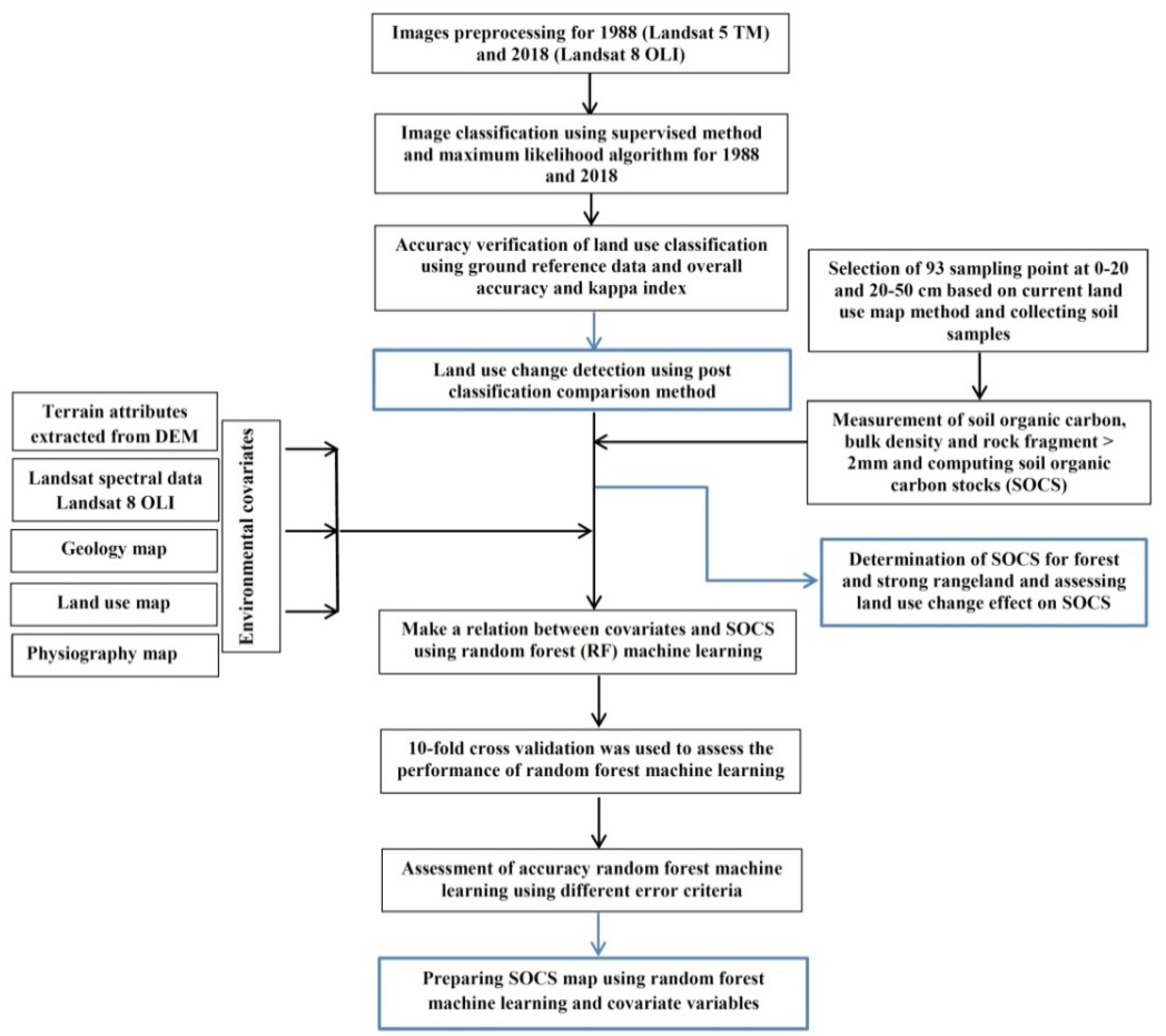
2. Materials and Methods
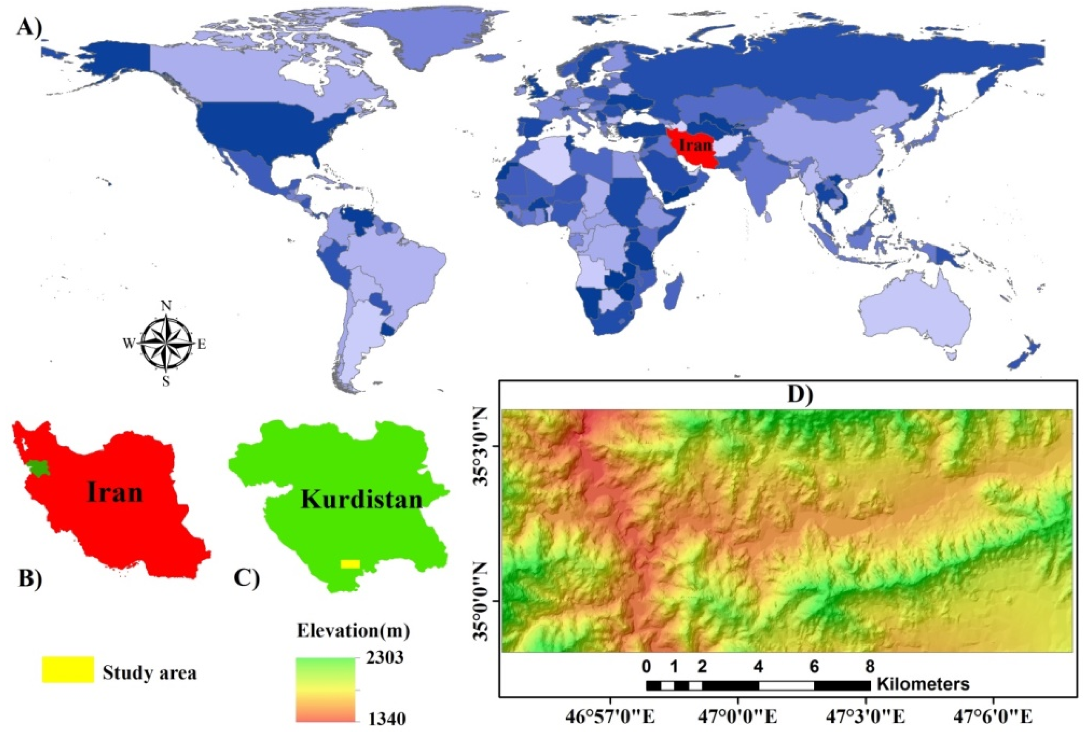
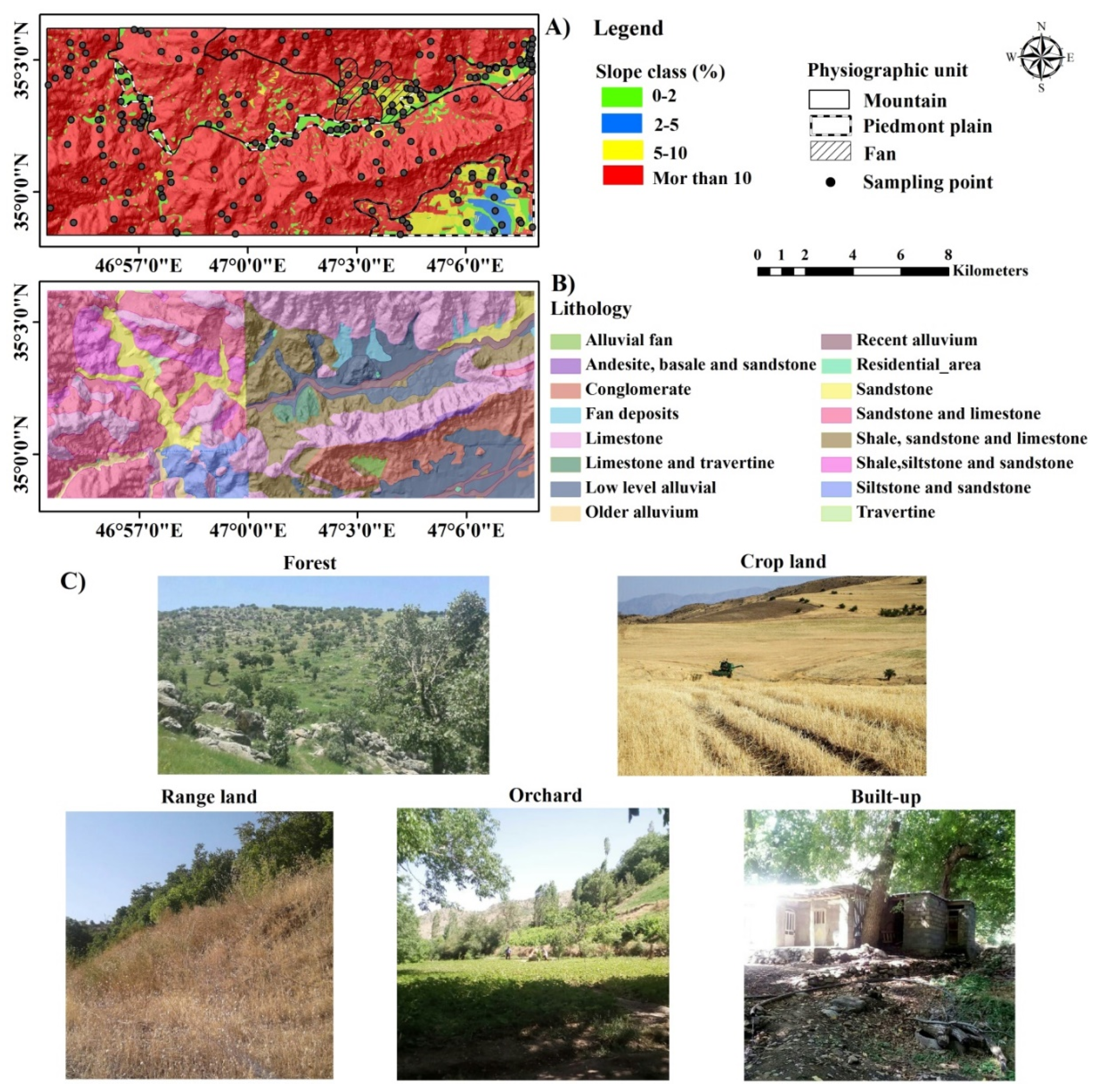
2.1. Study Area
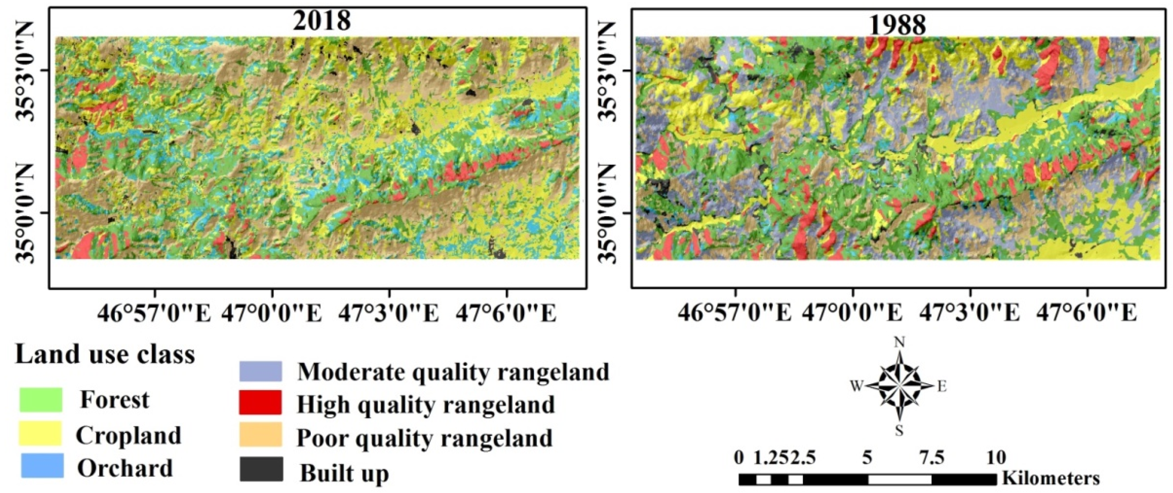
2.2. Land Use Change Detection
2.3. Soil Organic Carbon Stocks (SOCS)
2.4. Digital Map** of SOCS
2.4.1. Environmental Covariates
2.4.2. Random Forest
2.5. Reconstructing of SOCS in 1988
3. Results and Discussion
3.1. Accuracy Assessment of Land Use Classification
3.2. Land Use Change Trends
3.3. Summary Statistics of SOC and SOCS
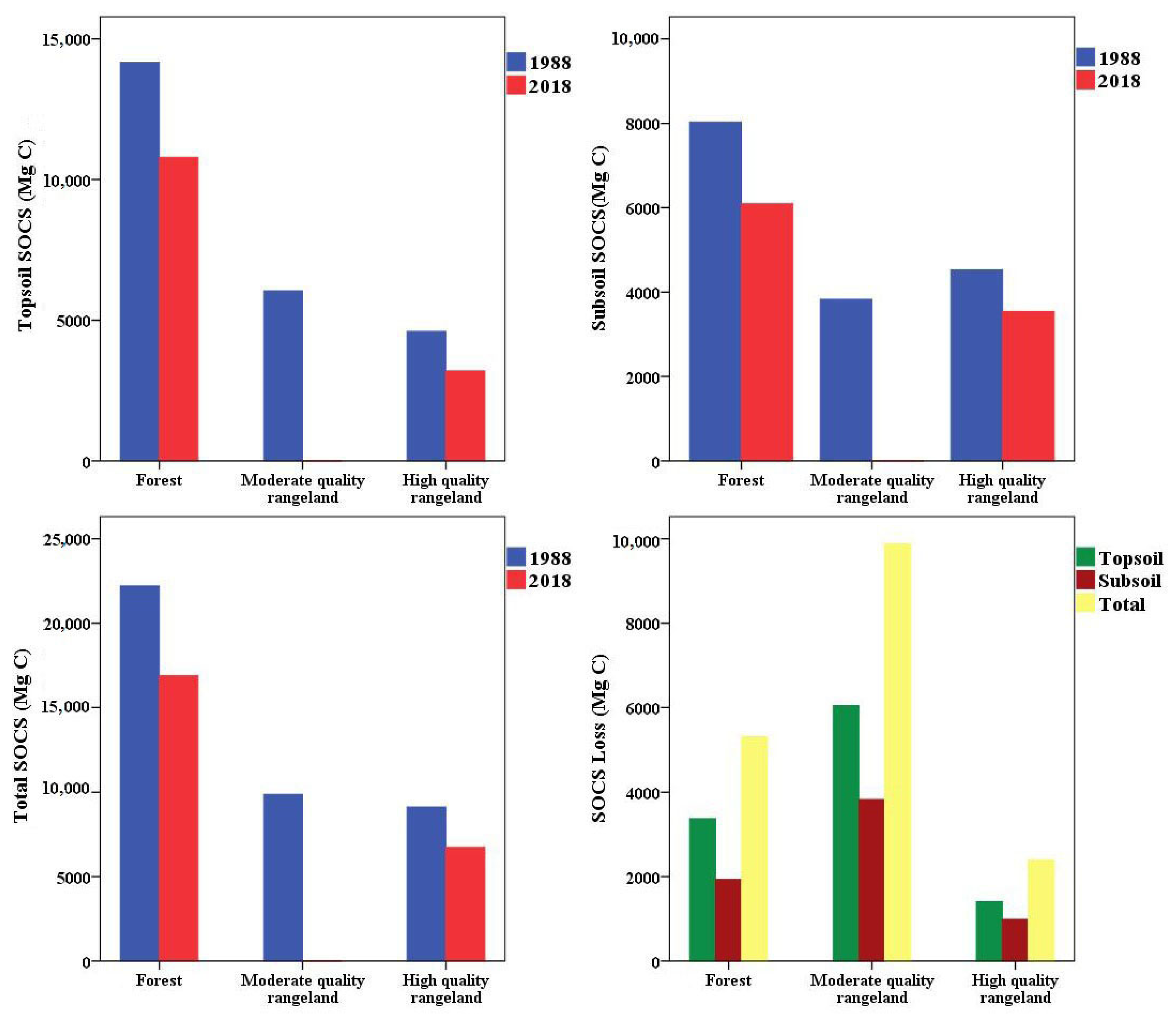
3.4. Link between SOCS and Land Use
3.5. SOCS Loss
3.6. Digital Map** of SOCS
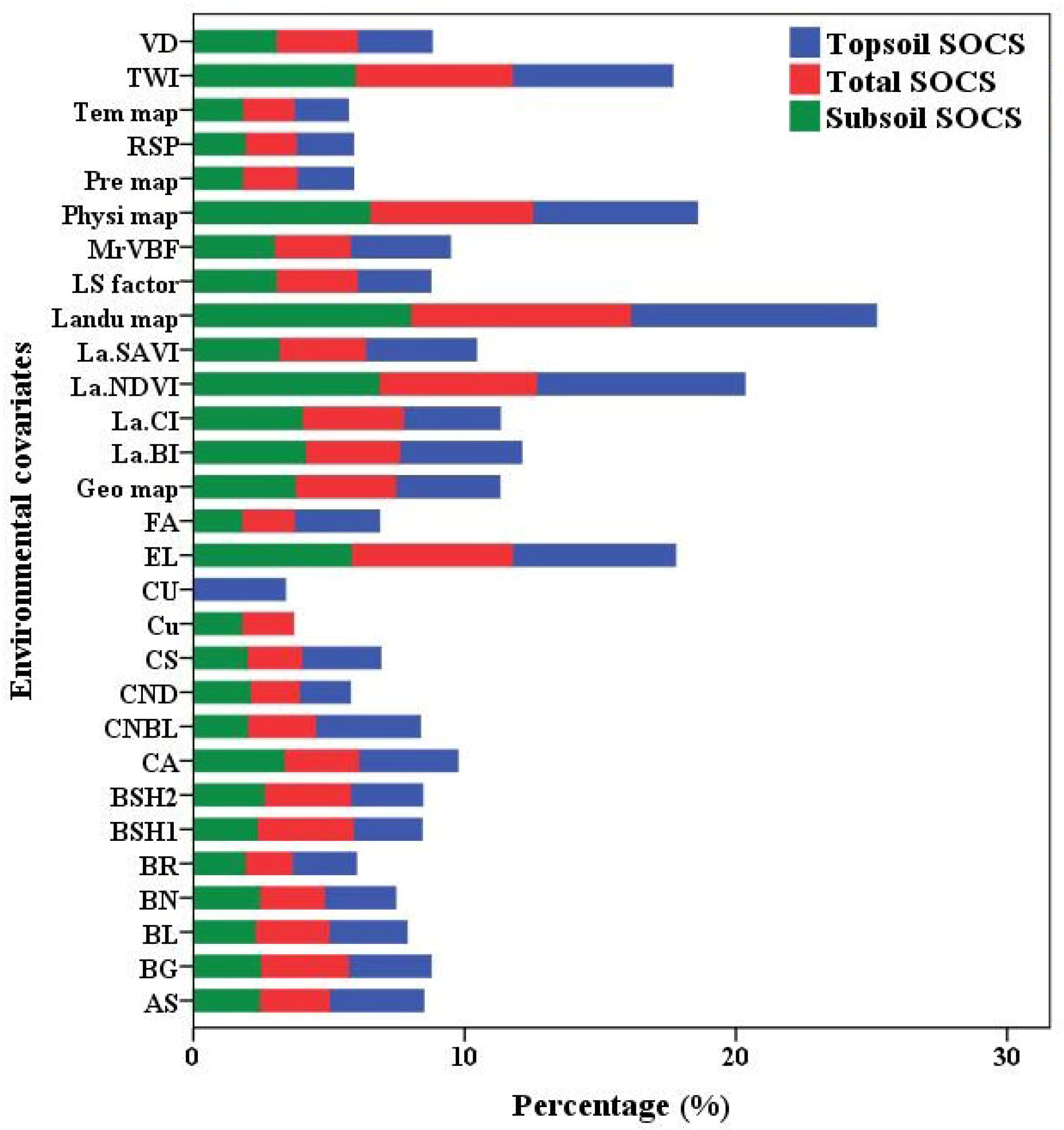
3.6.1. Covariate Importance
3.6.2. Random Forests
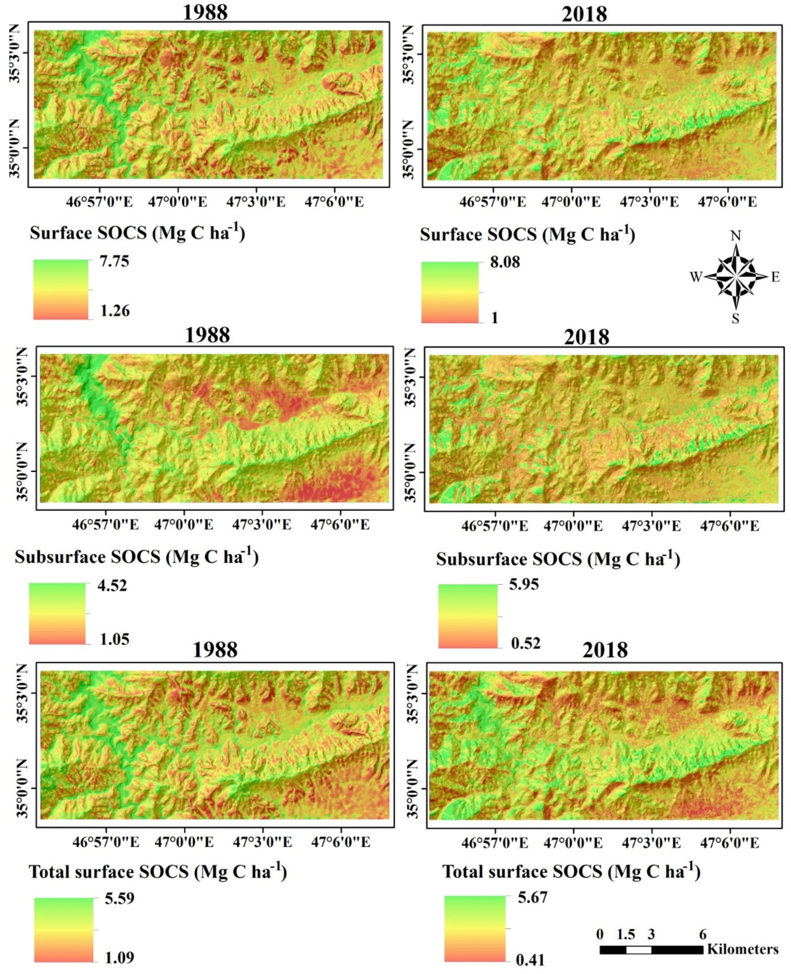
3.6.3. Spatial Distribution of SOCS
4. Conclusions
Author Contributions
Funding
Institutional Review Board Statement
Informed Consent Statement
Data Availability Statement
Acknowledgments
Conflicts of Interest
References
- Crowson, M.; Hagensieker, R.; Waske, B. Map** land cover change in northern Brazil with limited training data. Int. J. Appl. Earth Obs. Geoinf. 2019, 78, 202–214. [Google Scholar] [CrossRef]
- Du, P.; Wang, X.; Chen, D.; Liu, S.; Lin, G.; Meng, Y. An improved change detection approach using tri-temporal log-ic-verified change vector analysis. ISPRS J. Photogramm. 2020, 161, 278–293. [Google Scholar] [CrossRef]
- ** and change detection. Remote Sens. Environ. 2019, 231, 111212. [Google Scholar] [CrossRef]
- Schulze, R.E.; Schütte, S. Map** soil organic carbon at a terrain unit resolution across South Africa. Geoderma 2020, 373, 114447. [Google Scholar] [CrossRef]
- Pal, S.; Ziaul, S. Detection of land use and land cover change and land surface temperature in English Bazar urban centre. Egypt. J. Remote Sens. Space Sci. 2017, 20, 125–145. [Google Scholar] [CrossRef] [Green Version]
- Akinyemi, F.O. Land change in the central Albertine rift: Insights from analysis and map** of land use-land cover change in north-western Rwanda. Appl. Geogr. 2017, 87, 127–138. [Google Scholar] [CrossRef]
- Huang, H.B.; Chen, Y.L.; Clinton, N.; Wang, J.; Wang, X.Y.; Liu, C.X.; Gong, P.; Yang, J.; Bai, Y.Q.; Zheng, Y.M.; et al. Map** major land cover dynamics in Bei**g using all Landsat images in Google Earth Engine. Remote Sens. Environ. 2017, 202, 166–176. [Google Scholar] [CrossRef]
- Jombo, S.; Adam, E.; Odindi, J. Quantification of landscape transformation due to the Fast Track Land Reform Programme (FTLRP) in Zimbabwe using remotely sensed data. Land Use Policy 2017, 68, 287–294. [Google Scholar] [CrossRef]
- Giuliani, G.; Dao, H.; de Bono, A.; Chatenoux, B.; Allenbach, K.; de Laborie, P.; Rodila, D.; Alexandris, N.; Peduzzi, P. Live Monitoring of Earth Surface (LiMES): A framework for monitoring environmental changes from Earth Observations. Remote Sens. Environ. 2017, 202, 222–233. [Google Scholar] [CrossRef]
- Alijani, Z.; Hosseinali, F.; Biswas, A. Spatio-temporal evolution of agricultural land use change drivers: A case study from Chalous region, Iran. J. Environ. Manag. 2020, 262, 110326. [Google Scholar] [CrossRef]
- Yin, H.; Pflugmacher, D.; Li, A.; Li, Z.; Hostert, P. Land use and land cover change in Inner Mongolia—Understanding the effects of China’s re-vegetation programs. Remote Sens. Environ. 2018, 204, 918–930. [Google Scholar] [CrossRef]
- Kumar, S.; Shwetank; Jain, K. A Multi-Temporal Landsat Data Analysis for Land-use/Land-cover Change in Haridwar Region using Remote Sensing Techniques. Procedia Comput. Sci. 2020, 171, 1184–1193. [Google Scholar] [CrossRef]
- Salem, M.; Tsurusaki, N.; Divigalpitiya, P. Remote sensing-based detection of agricultural land losses around Greater Cairo since the Egyptian revolution of 2011. Land Use Policy 2020, 97, 104744. [Google Scholar] [CrossRef]
- Mei, A.; Manzo, C.; Fontinovo, G.; Bassani, C.; Allegrini, A.; Petracchini, F. Assessment of land cover changes in Lampedusa Island (Italy) using Landsat TM and OLI data. J. Afr. Earth Sci. 2016, 122, 15–24. [Google Scholar] [CrossRef]
- USGS. Product Guide: Provisional Landsat 8 Surface Reflectance Product Guide; USGS: Reston, VA, USA, 2018.
- Mosammam, H.M.; Nia, J.T.; Khani, H.; Teymouri, A.; Kazemi, M. Monitoring land use change and measuring urban sprawl based on its spatial forms: The case of Qom city. Egypt. J. Remote Sens. Space Sci. 2017, 20, 103–116. [Google Scholar]
- Singh, P.; Kikon, N.; Verma, P. Impact of land use change and urbanization on urban heat island in Lucknow city, Central India. A remote sensing based estimate. Sustain. Cities Soc. 2017, 32, 100–114. [Google Scholar] [CrossRef]
- Foody, G.M. Status of land cover classification accuracy assessment. Remote Sens. Environ. 2002, 80, 185–201. [Google Scholar] [CrossRef]
- Abd-EL-kawy, O.R.; Ismail, H.A.; Yehia, H.M. Temporal detection and prediction of agricultural land consumption by urbanization using remote sensing. Egypt. J. Remote Sens. Space Sci. 2019, 22, 237–246. [Google Scholar] [CrossRef]
- Mishra, S.; Shrivastava, P.; Dhurvey, P. Maulana Azad National Institute of Technology Bhopal Change Detection Techniques in Remote Sensing: A Review. Int. J. Wirel. Mob. Commun. Ind. Syst. 2017, 4, 1–8. [Google Scholar] [CrossRef]
- Raja, R.A.A.; Anand, V.; Kumar, A.S.; Maithani, S.; Kumar, V.A. Wavelet Based Post Classification Change Detection Technique for Urban Growth Monitoring. J. Indian Soc. Remote Sens. 2013, 41, 35–43. [Google Scholar] [CrossRef]
- Wu, C.; Du, B.; Cui, X.; Zhang, L. A post-classification change detection method based on iterative slow feature analysis and Bayesian soft fusion. Remote Sens. Environ. 2017, 199, 241–255. [Google Scholar] [CrossRef]
- Nelson, D.W.; Sommers, L.E. Total Carbon, Organic Carbon, and Organic Matter. In Methods of Soil Analysis, Part 2-Chemical and Microbiological Properties; Page, A.L., Miller, R.H., Keeney, D.R., Eds.; ASA-SSSA: Madison, WI, USA, 1982; pp. 539–594. [Google Scholar]
- Grossman, R.B.; Reinsch, T.G. 2.1 Bulk Density and Linear Extensibility; Wiley: Hoboken, NJ, USA, 2018; pp. 201–228. [Google Scholar]
- Ajami, M.; Heidari, A.; Khormali, F.; Gorji, M.; Ayoubi, S. Environmental factors controlling soil organic carbon storage in loess soils of a subhumid region, northern Iran. Geoderma 2016, 281, 1–10. [Google Scholar] [CrossRef]
- Adhikari, K.; Hartemink, A.E. Soil organic carbon increases under intensive agriculture in the Central Sands, Wisconsin, USA. Geoderma Reg. 2017, 10, 115–125. [Google Scholar] [CrossRef]
- Hamzehpour, N.; Shafizadeh-Moghadam, H.; Valavi, R. Exploring the driving forces and digital map** of soil organic carbon using remote sensing and soil texture. Catena 2019, 182, 104141. [Google Scholar] [CrossRef]
- Keskin, H.; Grunwald, S.; Harris, W.G. Digital map** of soil carbon fractions with machine learning. Geoderma 2019, 339, 40–58. [Google Scholar] [CrossRef]
- Lamichhane, S.; Kumar, L.; Wilson, B. Digital soil map** algorithms and covariates for soil organic carbon map** and their implications: A review. Geoderma 2019, 352, 395–413. [Google Scholar] [CrossRef]
- Minasny, B.; McBratney, A.B.; Malone, B.P.; Wheeler, I. Digital Map** of Soil Carbon. Adv. Agron. 2013, 118, 1–47. [Google Scholar] [CrossRef]
- Rial, M.; Cortizas, A.M.; Rodríguez-Lado, L. Understanding the spatial distribution of factors controlling topsoil organic carbon content in European soils. Sci. Total Environ. 2017, 609, 1411–1422. [Google Scholar] [CrossRef]
- Schillaci, C.; Acutis, M.; Lombardo, L.; Lipani, A.; Fantappie, M.; Marker, M.; Saia, S. Spatio-temporal topsoil organic carbon map** of a semi-arid Mediterranean region: The role of land use, soil texture, topographic indices and the influence of the remote sensing data to modeling. Sci. Total Environ. 2017, 601, 821–832. [Google Scholar] [CrossRef]
- Huete, A. A soil-adjusted vegetation index (SAVI). Remote Sens. Environ. 1988, 25, 295–309. [Google Scholar] [CrossRef]
- Metternicht, G.; Zinck, J. Remote sensing of soil salinity: Potentials and constraints. Remote Sens. Environ. 2003, 85, 1–20. [Google Scholar] [CrossRef]
- Rouse, J.W.; Hass, R.H.; Schell, J.A.; Deering, D.W. Monitoring vegetation systems in the Great Plains with ERTS. In Technical Presentations Section A Proceedings of the NASA SP-351: Third Earth Resources Technology Satellite-Symposium, Washington, DC, USA, 10–14 December 1973; Freden, S.C., Mercanti, E.P., Becker, M.A., Eds.; NASA Science and Technology Information: Washington, DC, USA, 1974; Volume 1, pp. 309–317. [Google Scholar]
- Boettinger, J.; Ramsey, R.; Bodily, J.; Cole, N.; Kienast-Brown, S.; Nield, S.; Saunders, A.; Stum, A. Landsat Spectral Data for Digital Soil Map**. In Digital Soil Map** with Limited Data; Metzler, J.B., Ed.; Springer: Berlin/Heidelberg, Germany, 2008; pp. 193–202. [Google Scholar]
- National Cartographic Center of Iran, Research Institute of National Cartographic Center, Tehran, Iran. 2014. Available online: http://www.ncc.org.ir/ (accessed on 14 February 2014).
- Olaya, V. A Gentle Introduction to SAGA GIS; The SAGA User Group e.V.: Gottingen, Germany, 2004; p. 216. [Google Scholar]
- Malone, B.P.; Jha, S.K.; Minasny, B.; McBratney, A.B. Comparing regression-based digital soil map** and multiple-point geostatistics for the spatial extrapolation of soil data. Geoderma 2016, 262, 243–253. [Google Scholar] [CrossRef]
- McBratney, A.; Santos, M.M.; Minasny, B. On digital soil map**. Geoderma 2003, 117, 3–52. [Google Scholar] [CrossRef]
- Minasny, B.; McBratney, A. Digital soil map**: A brief history and some lessons. Geoderma 2016, 264, 301–311. [Google Scholar] [CrossRef]
- Teng, H.; Rossel, R.A.V.; Shi, Z.; Behrens, T. Updating a national soil classification with spectroscopic predictions and digital soil map**. Catena 2018, 164, 125–134. [Google Scholar] [CrossRef]
- Taghizadeh-Mehrjardi, R.; Nabiollahi, K.; Rasoli, L.; Kerry, R.; Scholten, T. Land Suitability Assessment and Agricultural Production Sustainability Using Machine Learning Models. Agronomy 2020, 10, 573. [Google Scholar] [CrossRef]
- Wang, B.; Waters, C.; Orgill, S.; Gray, J.; Cowie, A.; Clark, A.; Liu, D.L. High resolution map** of soil organic carbon stocks using remote sensing variables in the semi-arid rangelands of eastern Australia. Sci. Total Environ. 2018, 630, 367–378. [Google Scholar] [CrossRef]
- Zeraatpisheh, M.; Bakhshandeh, E.; Hosseini, M.; Alavi, S.M. Assessing the effects of deforestation and intensive agriculture on the soil quality through digital soil map**. Geoderma 2020, 363, 114139. [Google Scholar] [CrossRef]
- Zhou, T.; Geng, Y.; Chen, J.; Liu, M.; Haase, D.; Lausch, A. Map** soil organic carbon content using multi-source remote sensing variables in the Heihe River Basin in China. Ecol. Indic. 2020, 114, 106288. [Google Scholar] [CrossRef]
- Breiman, L. Random Forests. Mach. Learn. 2001, 45, 12–20. [Google Scholar]
- Anderson, J.R.; Hardy, E.E.; Roach, J.T.; Witmer, R.E. A Land Use and Land Cover Classification System for Use with Remote Sensor Data; US Geological Survey: Reston, VA, USA, 1976; Volume 964. [Google Scholar]
- Piquer-Rodríguez, M.; Butsic, V.; Gärtner, P.; Macchi, L.; Baumann, M.; Pizarro, G.G.; Volante, J.; Gasparri, I.; Kuemmerle, T. Drivers of agricultural land-use change in the Argentine Pampas and Chaco regions. Appl. Geogr. 2018, 91, 111–122. [Google Scholar] [CrossRef]
- Watmough, G.R.; Palm, C.A.; Sullivan, C. An operational framework for object-based land use classification of heteroge-neous rural landscapes. Int. J. Appl. Earth Obs. Geoinf. 2017, 54, 134–144. [Google Scholar] [CrossRef]
- Haque, M.I.; Basak, R. Land cover change detection using GIS and remote sensing techniques: A spatio-temporal study on Tanguar Haor, Sunamganj, Bangladesh. Egypt. J. Remote Sens. Space Sci. 2017, 20, 251–263. [Google Scholar] [CrossRef]
- Sibanda, M.; Dube, T.; Mubango, T.; Shoko, C. The utility of earth observation technologies in understanding impacts of land reform in the eastern region of Zimbabwe. J. Land Use Sci. 2016, 11, 384–400. [Google Scholar] [CrossRef]
- Zembe, N.; Mbokochena, E.; Mudzengere, F.H.; Chikwriri, E. An assessment of the impact of the fast track land reform programme on the environment: The case of eastdale farm in gutu district masvingo. J. Geogr. Reg. Plan. 2014, 7, 160–175. [Google Scholar]
- Wilding, L.P. Spatial variability: Its documentation, accommodation and implication to soil surveys. In Proceedings of the Soil Spatial Variability, Las Vegas, NV, USA, 30 November–1 December 1985; pp. 166–194. [Google Scholar]
- Wang, S.; Adhikari, K.; Wang, Q.; **, X.; Li, H. Role of environmental variables in the spatial distribution of soil carbon (C), nitrogen (N), and C:N ratio from the northeastern coastal agroecosystems in China. Ecol. Indic. 2018, 84, 263–272. [Google Scholar] [CrossRef]
- Davari, M.; Gholami, L.; Nabiollahi, K.; Homaee, M.; Jafari, H.J. Deforestation and cultivation of sparse forest impacts on soil quality (case study: West Iran, Baneh). Soil Tillage Res. 2020, 198, 104504. [Google Scholar] [CrossRef]
- Tesfaye, M.A.; Bravo, F.; Ruiz-Peinado, R.; Pando, V.; Bravo-Oviedo, A. Impact of changes in land use, species and ele-vation on soil organic carbon and total nitrogen in Ethiopian central highlands. Geoderma 2016, 261, 70–79. [Google Scholar] [CrossRef]
- Villarino, S.H.; Studdert, G.A.; Baldassini, P.; Cendoya, M.G.; Ciuffoli, L.; Mastrángelo, M.; Piñeiro, G. Deforestation impacts on soil organic carbon stocks in the Semiarid Chaco Region, Argentina. Sci. Total Environ. 2017, 575, 1056–1065. [Google Scholar] [CrossRef] [PubMed] [Green Version]
- Kassa, H.; Dondeyne, S.; Poesen, J.; Frankl, A.; Nyssen, J. Impact of deforestation on soil fertility, soil carbon and nitrogen stocks: The case of the Gacheb catchment in the White Nile Basin, Ethiopia. Agric. Ecosyst. Environ. 2017, 247, 273–282. [Google Scholar] [CrossRef] [Green Version]
- Wang, Z.; Hu, Y.; Wang, R.; Guo, S.; Du, L.; Zhao, M.; Yao, Z. Soil organic carbon on the fragmented Chinese Loess Plateau: Combining effects of vegetation types and topographic positions. Soil Tillage Res. 2017, 174, 1–5. [Google Scholar] [CrossRef]
- Nabiollahi, K.; Golmohamadi, F.; Taghizadeh-Mehrjardi, R.; Kerry, R.; Davari, M. Assessing the effects of slope gradient and land use change on soil quality degradation through digital map** of soil quality indices and soil loss rate. Geoderma 2018, 318, 16–28. [Google Scholar] [CrossRef]
- Nabiollahi, K.; Taghizadeh-Mehrjardi, M.; Eskandari, S. Assessing and monitoring the soil quality of forested and agri-cultural areas using soil-quality indices and digital soil-map** in a semi-arid environment. Arch. Agron. Soil Sci. 2018, 64, 482–494. [Google Scholar] [CrossRef]
- Khormali, F.; Ajami, M.; Ayoubi, S.; Srinivasarao, C.; Wani, S. Role of deforestation and hillslope position on soil quality attributes of loess-derived soils in Golestan province, Iran. Agric. Ecosyst. Environ. 2009, 134, 178–189. [Google Scholar] [CrossRef]
- Li, Z.; Liu, C.; Dong, Y.; Chang, X.; Nie, X.; Liu, L.; ** and spatial generalization. Ecol. Indic. 2017, 77, 139–150. [Google Scholar] [CrossRef]
- Smith, P. Soils and climate change. Curr. Opin. Environ. Sustain. 2012, 4, 539–544. [Google Scholar] [CrossRef]
- Akpa, S.I.; Odeh, I.O.; Bishop, T.F.; Hartemink, A.E.; Amapu, I.Y. Total soil organic carbon and carbon sequestration potential in Nigeria. Geoderma 2016, 271, 202–215. [Google Scholar] [CrossRef]
- Metting, F.B.; Smith, J.L.; Amthor, J.S. Science needs and new technology for soil carbon sequestration. In Carbon Sequestration in Soils: Science, Monitoring and Beyond; Rosenberg, N.J., Izaurralde, R.C., Malone, E.L., Eds.; Battelle Press: Columbus, OH, USA, 1999; pp. 1–34. [Google Scholar]
- Post, W.M.; Izaurralde, R.C.; Mann, L.K.; Bliss, N. Monitoring and Verifying Soil Organic Carbon Sequestration. In Carbon Sequestration in Soils: Science, Monitoring, and Beyond, Proceedings of the St. Michaels Workshop; Battelle Press: Columbus, OH, USA, 1998; pp. 41–66. [Google Scholar]
- Mahmoudabadi, E.; Karimi, A.; Haghnia, G.H.; Sepehr, A. Digital soil map** using remote sensing indices, terrain attributes, and vegetation features in the rangelands of northeastern Iran. Environ. Monit. Assess. 2017, 189, 500. [Google Scholar] [CrossRef]
- Taghizadeh-Mehrjardi, M.; Nabiollahi, K.; Kerry, R. Digital map** of soil organic carbon at multiple depths using dif-ferent data mining techniques in Baneh region, Iran. Geoderma 2016, 253, 67–77. [Google Scholar]
- Hinge, G.; Surampalli, R.Y.; Goyal, M.K. Prediction of soil organic carbon stock using digital map** approach in humid India. Environ. Earth Sci. 2018, 77, 172. [Google Scholar] [CrossRef]
- Wang, S.; Zhuang, Q.; Jia, S.; **, X.; Wang, Q. Spatial variations of soil organic carbon stocks in a coastal hilly area of China. Geoderma 2018, 314, 8–19. [Google Scholar] [CrossRef]
- Yang, R.M.; Zhang, G.L.; Liu, F.; Lu, Y.Y.; Yang, F.; Yang, F.; Yang, M.; Zhao, Y.G.; Li, D.C. Comparison of boosted re-gression tree and random forest models for map** topsoil organic carbon concentration in an alpine ecosystem. Ecol. Indic. 2016, 60, 870–878. [Google Scholar] [CrossRef]
- Guo, L.; Fu, P.; Shi, T.; Chen, Y.; Zhang, H.; Meng, R.; Wang, S. Map** field-scale soil organic carbon with unmanned aircraft system-acquired time series multispectral images. Soil Tillage Res. 2020, 196, 104477. [Google Scholar] [CrossRef]
- Ellili, Y.; Walter, C.; Michot, D.; Pichelin, P.; Lemercier, B. Map** soil organic carbon stock change by soil monitoring and digital soil map** at the landscape scale. Geoderma 2019, 351, 1–8. [Google Scholar] [CrossRef]


| Years | Mean Absolute Minimum Temperature | Mean Absolute Maximum Temperature °C | Mean Temperature °C | Evaporation mm | Wind Velocity ms−1 | Precipitation mm |
|---|---|---|---|---|---|---|
| 1988 | 1.4 | 26.5 | 13.4 | 141.8 | 15.2 | 535 |
| 2018 | 2.1 | 28.5 | 14.3 | 164.23 | 13.2 | 591 |
| Covariate Data Source | Symbol | Attribute |
|---|---|---|
| Digital Elevation Model | AS | Aspect |
| CA | Catchment area | |
| CS | Catchment slope | |
| CNBL | Catchment network base level | |
| CND | Catchment network distance | |
| EL | Elevation | |
| LS factor | Slope length factor | |
| MrVBF | Multi-resolution valley bottom flatness | |
| CU | Curvature | |
| RSP | Relative slope position | |
| SL | Slope | |
| TWI | Topographic wetness index | |
| VD | Valley depth | |
| FA | Flow accumulation | |
| Landsat 8 | BL | Blue band |
| BG | Green band | |
| BR | Red band | |
| BN | Near infrared | |
| BSH1 | Shortwave IR-1 | |
| BSH2 | Shortwave IR-2 | |
| CI | Clay index: (SWIR-1/SWIR-2) | |
| BI | Brightness index: ((RED)2+(NIR)2)0.5 | |
| NDVI | Normalized difference vegetation index: (NIR − RED)/(NIR + RED) | |
| SAVI | (1 + L) × (NIR − RED)/(NIR + RED + L) | |
| EVI | Enhanced vegetation index: (NIR − RED)/(NIR + C1 × RED − C2 × BLUE + L2) | |
| Land use map | Landu map | Land use unit |
| Geology map | Geo map | Geology unit |
| Physiography map | Physi map | Physiographic unit |
| Temperature map | Tem map | Mean annual temperature |
| Precipitation map | Pre map | Mean annual precipitation |
| Years | Land Use Class | Poor-Quality Rangeland | Forest | Built-Up | Orchard | Moderate-Quality Rangeland | High-Quality Rangeland | Cropland | Total | User’s Accuracy (%) |
|---|---|---|---|---|---|---|---|---|---|---|
| 1988 | Poor-quality rangeland | 15 | 1 | 0 | 0 | 0 | 0 | 0 | 16 | 93.75 |
| Forest | 0 | 23 | 0 | 4 | 0 | 0 | 0 | 27 | 85.18 | |
| Built-up | 0 | 0 | 6 | 0 | 0 | 0 | 0 | 6 | 100 | |
| Orchard | 0 | 0 | 0 | 8 | 0 | 0 | 0 | 8 | 100 | |
| Moderate-quality rangeland | 0 | 2 | 0 | 0 | 11 | 0 | 0 | 13 | 84.61 | |
| High-quality rangeland | 0 | 0 | 0 | 0 | 0 | 10 | 0 | 10 | 100 | |
| Cropland | 0 | 0 | 0 | 1 | 0 | 4 | 15 | 20 | 75 | |
| Total | 15 | 26 | 6 | 13 | 11 | 14 | 15 | 100 | ||
| Producer’s Accuracy (%) | 100 | 88.46 | 100 | 61.53 | 100 | 71 | 100 | |||
| Overall accuracy (%) | 88 | |||||||||
| Kappa index (%) | 85 | |||||||||
| 2018 | Poor-quality rangeland | 2 | 0 | 0 | 0 | - | 1 | 16 | 19 | 82.85 |
| Forest | 2 | 9 | 1 | 0 | - | 1 | 1 | 14 | 64.28 | |
| Built-up | 0 | 0 | 0 | 8 | - | 0 | 0 | 8 | 90.90 | |
| Orchard | 1 | 0 | 1 | 0 | - | 11 | 0 | 13 | 100 | |
| High-quality rangeland | 1 | 0 | 10 | 0 | - | 0 | 0 | 11 | 84.61 | |
| Cropland | 29 | 1 | 1 | 2 | - | 1 | 1 | 35 | 84.21 | |
| Total | 35 | 10 | 13 | 10 | - | 14 | 18 | 100 | ||
| Producer’s Accuracy (%) | 82.85 | 90 | 76.92 | 80 | - | 78.57 | 88.88 | |||
| Overall accuracy (%) | 83 | |||||||||
| Kappa index (%) | 78 |
| Land Use Unit | Area | Change Area | Rate | Changed Area | Rate | |||
|---|---|---|---|---|---|---|---|---|
| (ha) | (%) | (ha) | (%) | (ha) | (%) | |||
| 1988 | 2018 | 1988 | 2018 | Loss | Gain | |||
| Forest | 4723.11 | 3670.965 | 26.61 | 20.68 | −1052.14 | −22.27 | ||
| High-quality rangeland | 1468.26 | 1037.813 | 8.27 | 5.85 | −430.44 | −29.31 | ||
| Moderate-quality rangeland | 3595.77 | 0 | 20.26 | 0 | −3595.77 | −100 | ||
| Built-up | 603.27 | 395.32 | 3.40 | 2.23 | −207.94 | −34.46 | ||
| Cropland | 3698.01 | 5338.08 | 20.84 | 30.08 | +1640.05 | +30.72 | ||
| Poor-quality rangeland | 2766.69 | 4664.61 | 15.59 | 26.28 | +1897.92 | +40.68 | ||
| Orchard | 892.89 | 2641.21 | 5.03 | 14.88 | +1748.32 | +66.19 | ||
| Sum | 17,748 | 17,748 | 100 | 100 | 5286.29 | 5286.29 | ||
| Depth (cm) | Number | Mean | Minimum | Maximum | Standard Deviation | Skewness | Kurtosis | CV | |
|---|---|---|---|---|---|---|---|---|---|
| SOC (%) | 0–20 | 93 | 0.89 | 0.07 | 2.96 | 0.61 | 0.90 | 0.68 | 69.91 |
| BD (g cm−3) | 0–20 | 93 | 1.49 | 1.2 | 1.89 | 0.17 | 0.38 | 0.38 | 11.78 |
| Rock fragment >2 mm (%) | 0–20 | 93 | 33.78 | 0.00 | 84.88 | 21.29 | 0.56 | −0.26 | 65.38 |
| SOC Stock (Mg C ha−1) | 0–20 | 93 | 1.73 | 0.07 | 8.18 | 1.33 | 1.53 | 4.59 | 80.21 |
| SOC (%) | 20–50 | 93 | 0.46 | 0.04 | 2.03 | 0.38 | 1.69 | 3.59 | 84.01 |
| BD (g cm−3) | 20–50 | 93 | 1.35 | 1.1 | 1.88 | 0.25 | −0.23 | −0.23 | 17.25 |
| Rock fragment >2 mm (%) | 20–50 | 93 | 33.71 | 0.00 | 89.00 | 23.56 | 0.52 | −0.48 | 70.29 |
| SOC Stock (Mg C ha−1) | 20–50 | 93 | 1.35 | 0.05 | 6.87 | 1.25 | 1.81 | 4.16 | 96.33 |
| Land Use | Slope Class | Total of Soil Samples | |||||||||||||
|---|---|---|---|---|---|---|---|---|---|---|---|---|---|---|---|
| 0–2% (Flat) | 2–5% (Southern) | 5–10% (Northern) | 10%< (Eastern) | ||||||||||||
| 0–20 | 20–50 | 0–50 | 0–20 | 20–50 | 0–50 | 0–20 | 20–50 | 0–50 | 0–20 | 20–50 | 0–50 | 0–20 | 20–50 | 0–50 | |
| cm | cm | cm | cm | ||||||||||||
| Forest | - | - | - | - | - | - | - | - | - | 2.94a | 1.66ab | 4.6ab | 2.94a | 1.66b | 4.6b |
| High-quality rangeland | 4.48a | 4.12a | 8.60a | 2.88a | 3.61a | 6.49a | 3.02a | 2.70a | 5.72a | 2.83ab | 2.63a | 5.46a | 3.08a | 3.41a | 6.49a |
| Cropland | 1.61b | 2.00b | 3.61b | 1.43b | 1.08b | 2.51b | 1.30a | 1.31a | 2.61a | 2.24ab | 0.95c | 3.19abc | 1.49b | 1.39b | 2.88bc |
| Poor-quality rangeland | - | - | - | 0.99b | 1.03b | 2.02b | 2.01a | 1.13a | 2.14a | 0.84c | 0.55c | 1.39c | 1.17b | 0.90b | 2.07c |
| Orchard | 1.37b | 0.86b | 2.23b | 1.21b | 0.80b | 2.01b | 2.17a | 0.99a | 3.16a | 1.48ab | 1.02c | 2.50bc | 1.79b | 0.90b | 2.69c |
| p = (Tukey’s test) | <0.05 ** | <0.05 ** | <0.05 ** | <0.05 ** | <0.05 ** | <0.05 ** | ns | ns | ns | <0.05 ** | ns | <0.05 ** | <0.05 ** | <0.05 ** | <0.05 ** |
Publisher’s Note: MDPI stays neutral with regard to jurisdictional claims in published maps and institutional affiliations. |
© 2021 by the authors. Licensee MDPI, Basel, Switzerland. This article is an open access article distributed under the terms and conditions of the Creative Commons Attribution (CC BY) license (http://creativecommons.org/licenses/by/4.0/).
Share and Cite
Nabiollahi, K.; Shahlaee, S.; Zahedi, S.; Taghizadeh-Mehrjardi, R.; Kerry, R.; Scholten, T. Land Use and Soil Organic Carbon Stocks—Change Detection over Time Using Digital Soil Assessment: A Case Study from Kamyaran Region, Iran (1988–2018). Agronomy 2021, 11, 597. https://doi.org/10.3390/agronomy11030597
Nabiollahi K, Shahlaee S, Zahedi S, Taghizadeh-Mehrjardi R, Kerry R, Scholten T. Land Use and Soil Organic Carbon Stocks—Change Detection over Time Using Digital Soil Assessment: A Case Study from Kamyaran Region, Iran (1988–2018). Agronomy. 2021; 11(3):597. https://doi.org/10.3390/agronomy11030597
Chicago/Turabian StyleNabiollahi, Kamal, Shadi Shahlaee, Salahudin Zahedi, Ruhollah Taghizadeh-Mehrjardi, Ruth Kerry, and Thomas Scholten. 2021. "Land Use and Soil Organic Carbon Stocks—Change Detection over Time Using Digital Soil Assessment: A Case Study from Kamyaran Region, Iran (1988–2018)" Agronomy 11, no. 3: 597. https://doi.org/10.3390/agronomy11030597