Improved Landsat-Based Water and Snow Indices for Extracting Lake and Snow Cover/Glacier in the Tibetan Plateau


Abstract
:1. Introduction
2. Materials and Methods
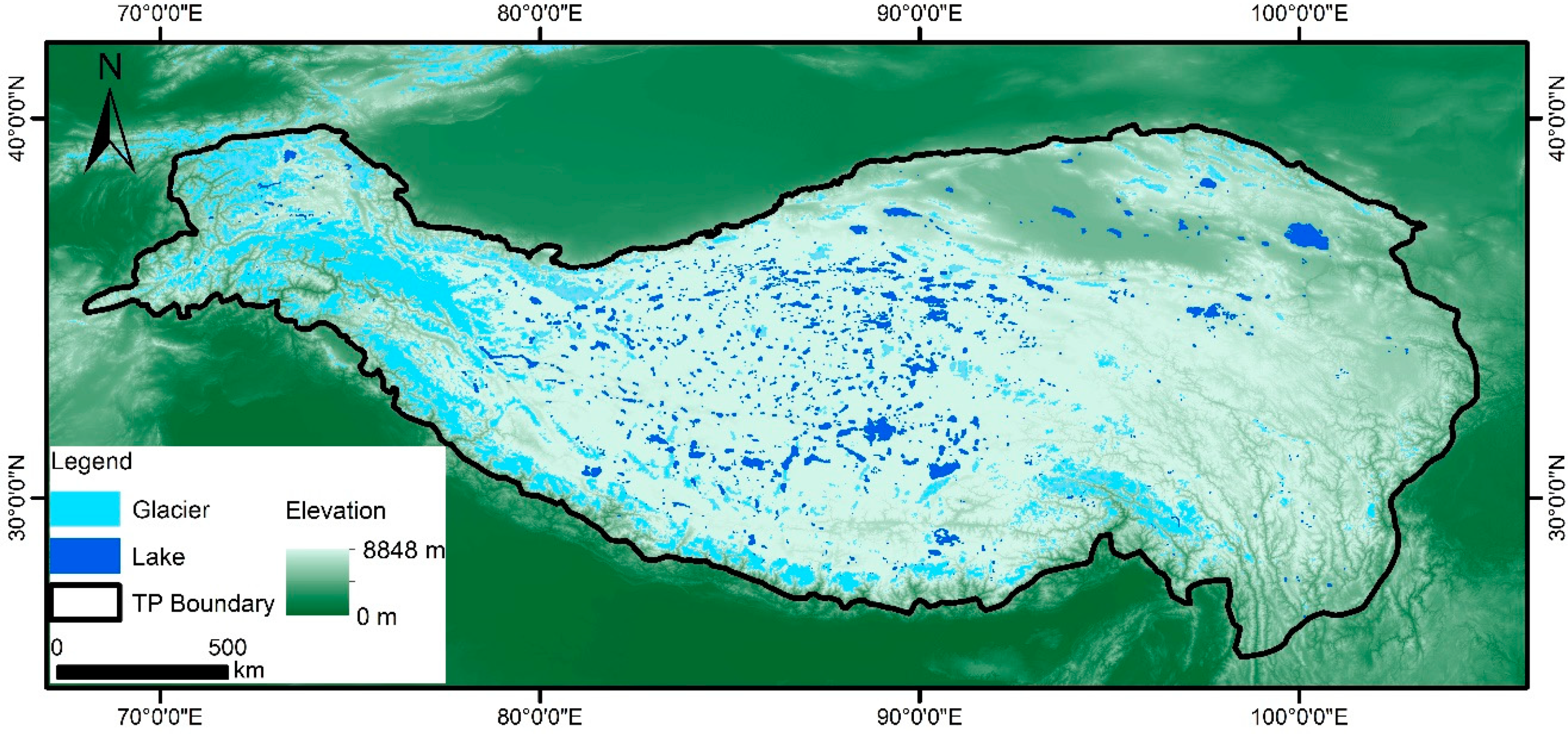
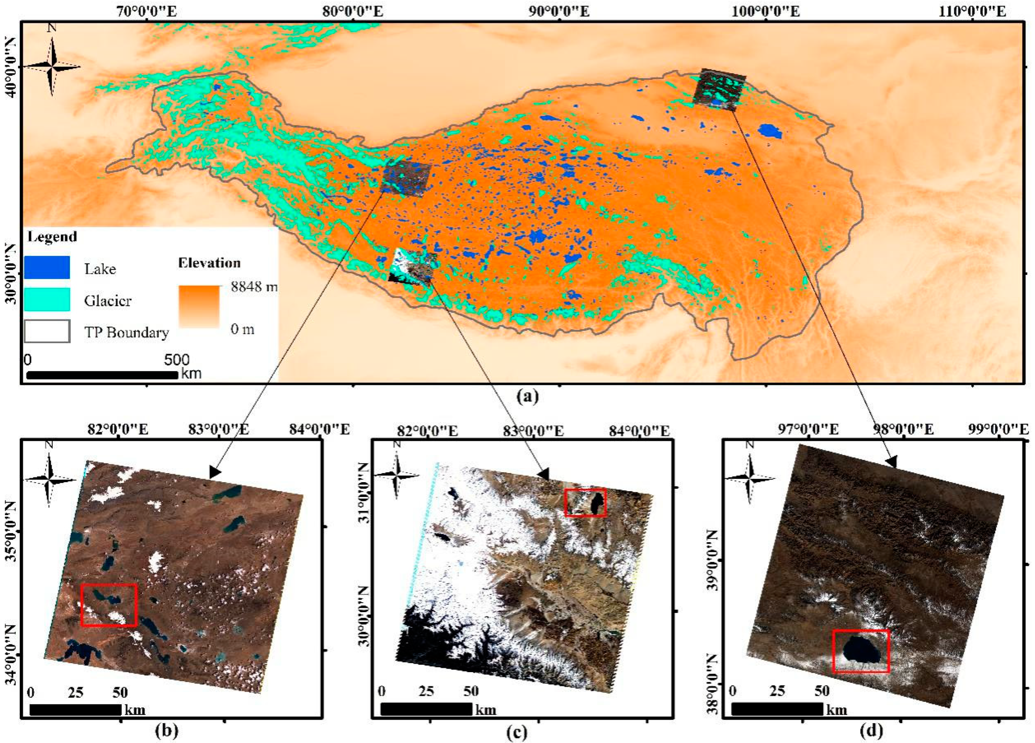
2.1. Regional Setting
2.2. Data
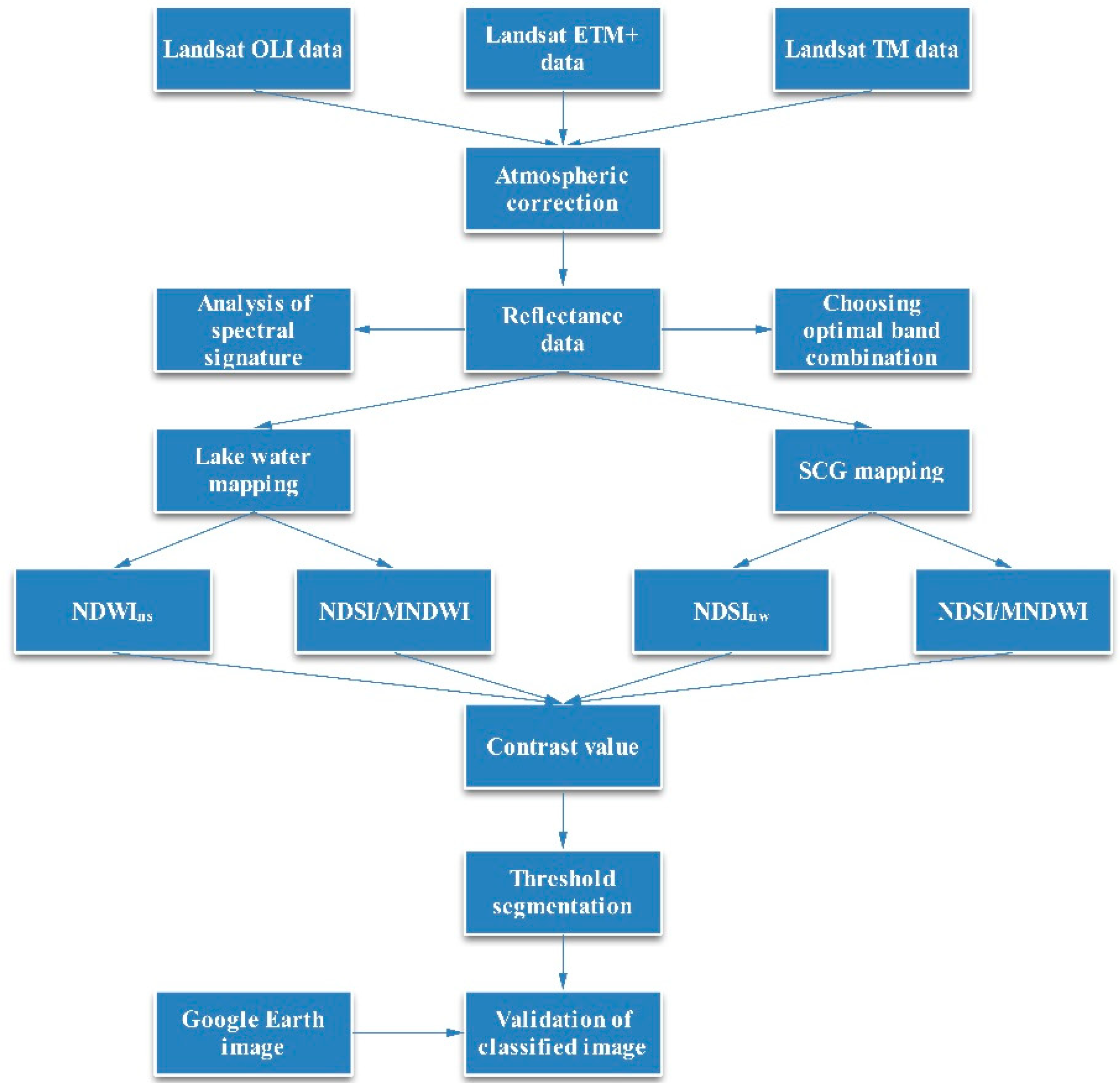
2.3. Methods
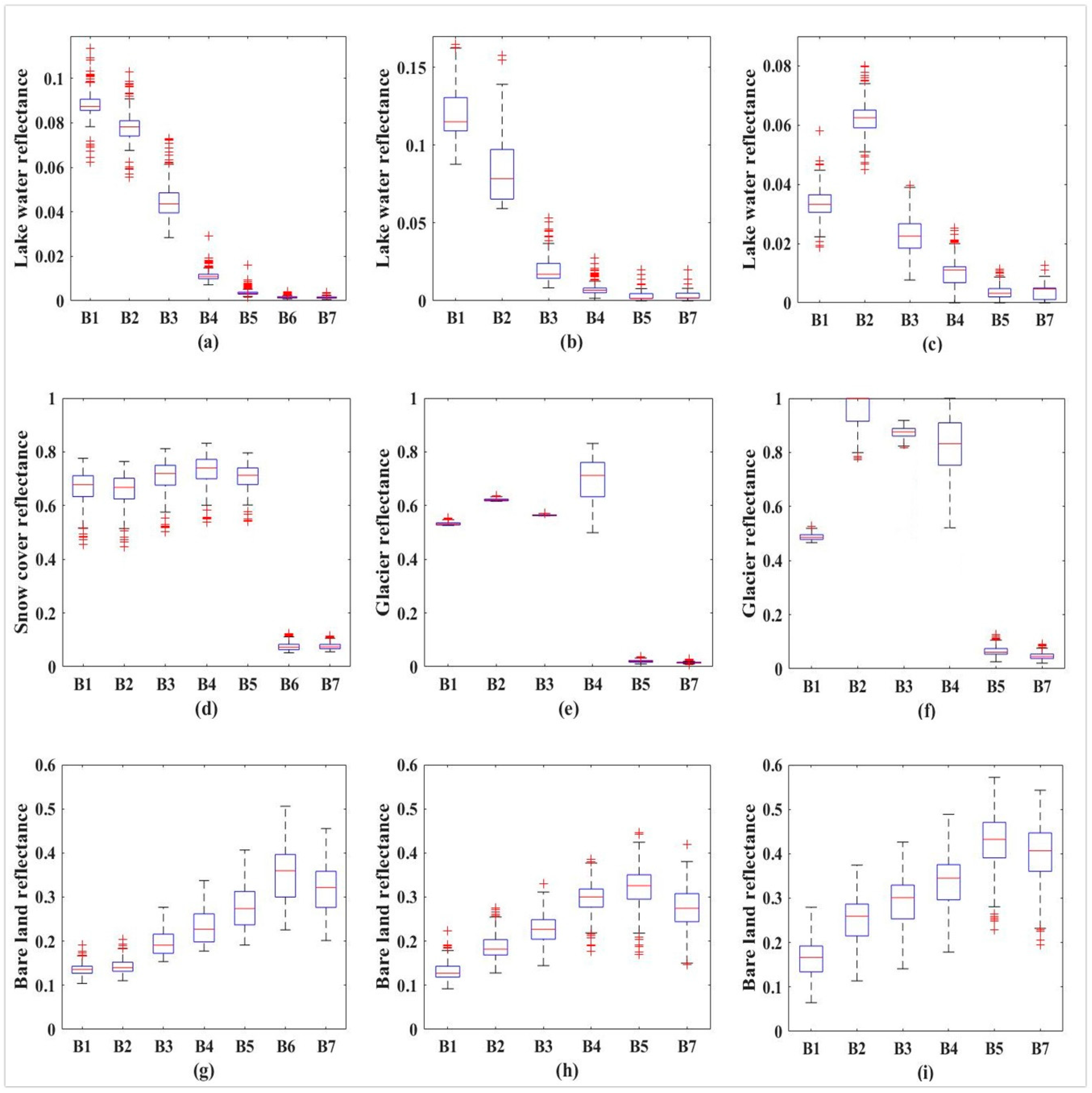
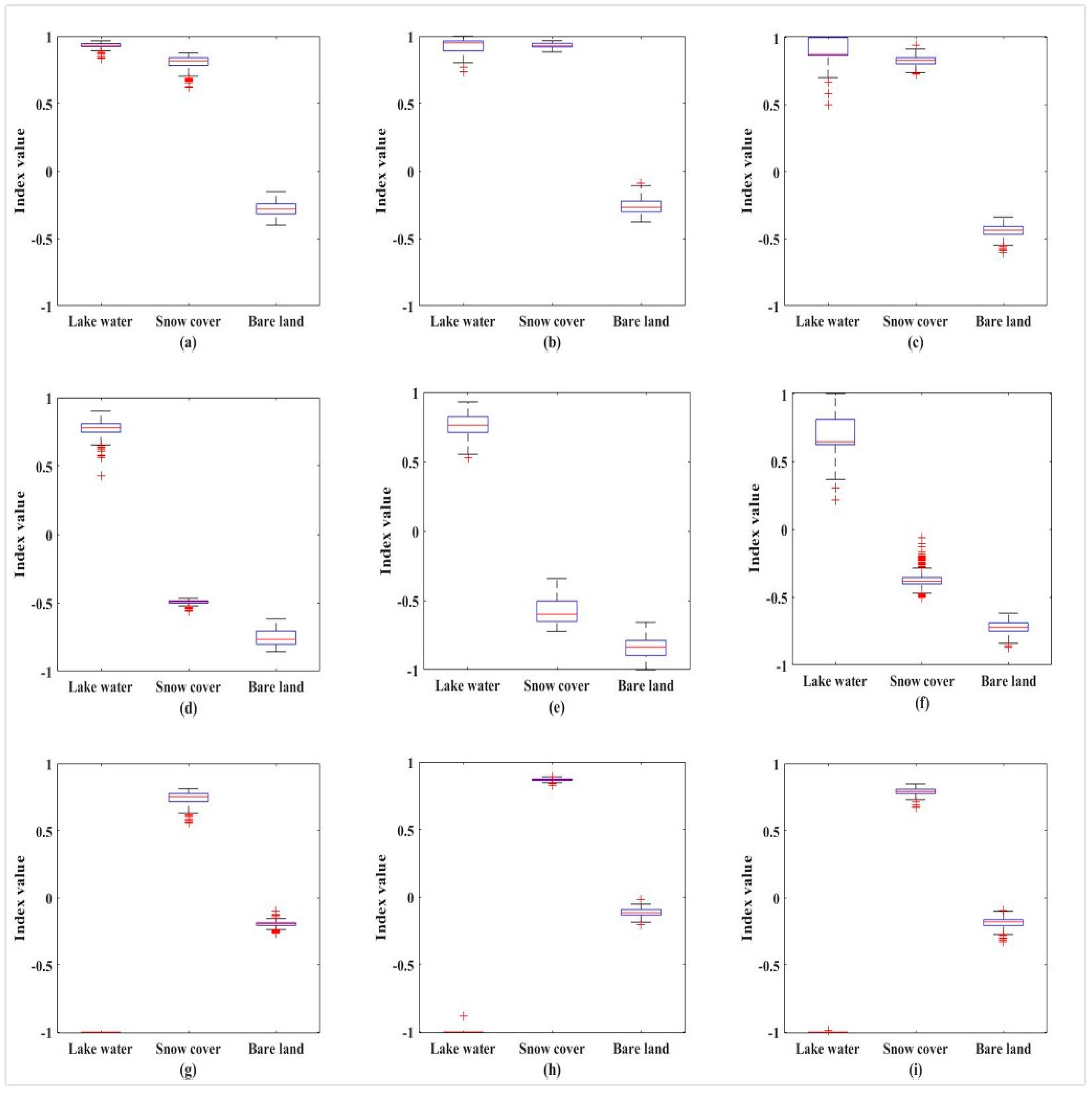
2.3.1. Spectral Signature of Lake Water and SCG
2.3.2. The Contrast Values of Five Indices between Lake Water and SCG
2.3.3. Formulation of Water Index and Snow Index
2.3.4. NDSI and MNDWI
2.3.5. Image Threshold Segmentation
2.3.6. Validation of Classified Image
3. Results
3.1. The Optimal Band Combination in Identifying between Lake Water and SCG
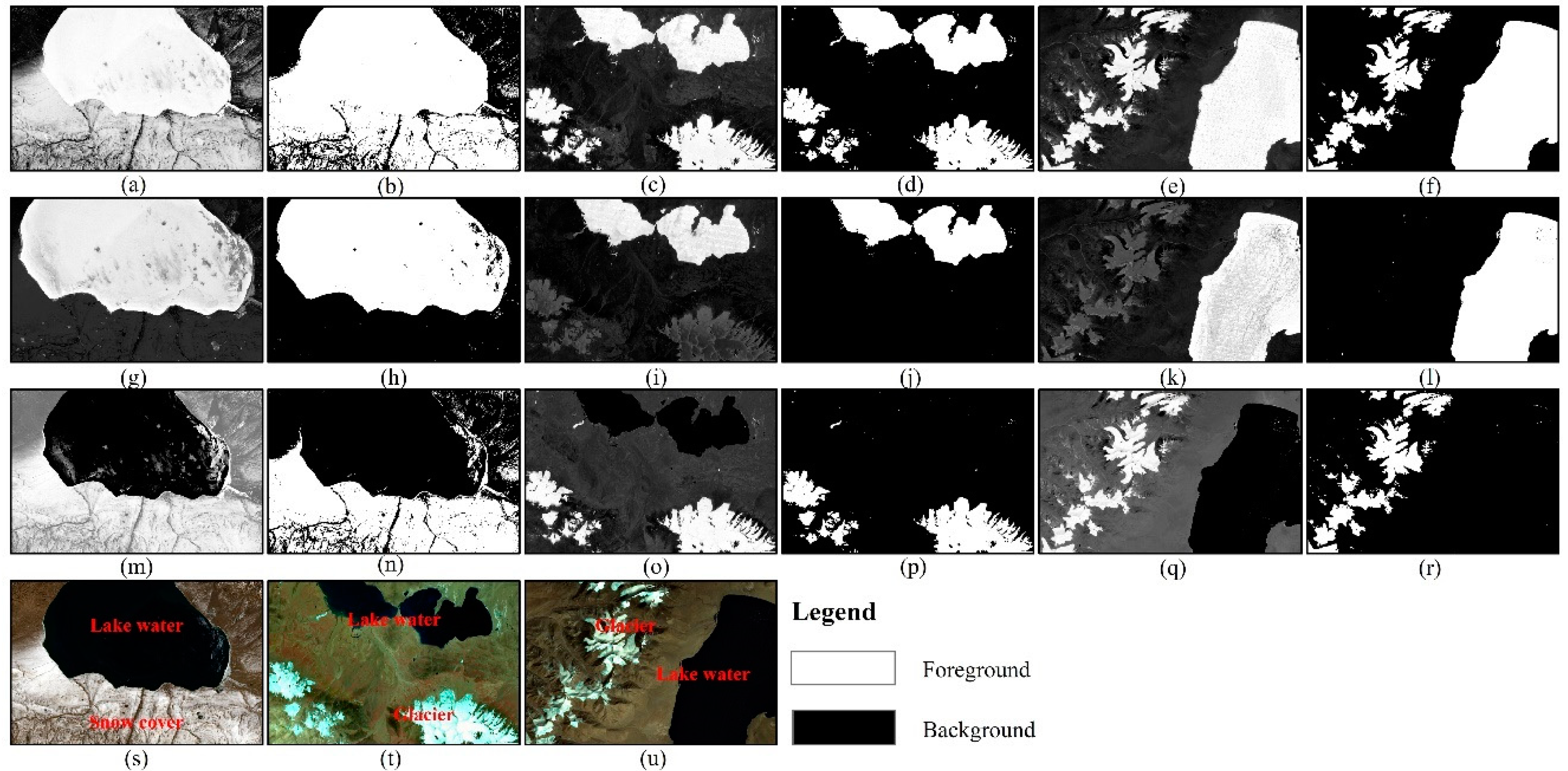
3.2. Lake Water Map** with Noise from SCG Using NDSI/MNDWI and NDWIns
3.3. SCG Map** with Noise from Lake Water Using NDSI/MNDWI and NDSInw
4. Discussion and Outlook
5. Conclusions
Author Contributions
Funding
Acknowledgments
Conflicts of Interest
References
- Huang, C.; Chen, Y.; Zhang, S.; Wu, J. Detecting, extracting, and monitoring surface water from space using optical sensors: A review. Rev. Geophys. 2018, 56, 333–360. [Google Scholar] [CrossRef]
- Biemans, H.; Siderius, C.; Lutz, A.F.; Nepal, S.; Ahmad, B.; Hassan, T.; von Bloh, W.; Wijngaard, R.R.; Wester, P.; Shrestha, A.B.; et al. Importance of snow and glacier meltwater for agriculture on the Indo-Gangetic Plain. Nature Sustain. 2019, 2, 594–601. [Google Scholar] [CrossRef]
- Busker, T.; Roo, A.D.; Gelati, E.; Schwatke, C.; Adamovic, M.; Bisselink, B.; Pekel, J.; Cottam, A. A global lake and reservoir volume analysis using a surface water dataset and satellite altimetry. Hydrol. Earth Syst. Sci. 2019, 23, 669–690. [Google Scholar] [CrossRef] [Green Version]
- Yao, T.; Thompson, L.G.; Mosbrugger, V.; Zhang, F.; Ma, Y.; Luo, T.; Xu, B.; Yang, X.; Joswiak, D.R.; Wang, W.; et al. Third pole environment (TPE). Environ. Dev. 2012, 3, 52–64. [Google Scholar] [CrossRef]
- Qiu, J. China: The third pole. Nature 2008, 454, 393–396. [Google Scholar] [CrossRef] [Green Version]
- Yao, T.; Xue, Y.; Chen, D.; Chen, F.; Thompson, L.; Cui, P.; Koike, T.; Lau, W.K.M.; Lettenmaier, D.; Mosbrugger, V.; et al. Recent Third Pole’s Rapid Warming Accompanies Cryospheric Melt and Water Cycle Intensification and Interactions between Monsoon and Environment: Multidisciplinary Approach with Observations, Modeling, and Analysis. Bull. Am. Meteorol. Soc. 2019, 100, 423–444. [Google Scholar] [CrossRef]
- Yao, T.; Thompson, L.G.; Yang, W.; Yu, W.; Gao, Y.; Guo, X.; Yang, X.; Duan, K.; Zhao, H.; Xu, B.; et al. Different glacier status with atmospheric circulations in Tibetan Plateau and surroundings. Nat. Clim. Chang. 2012, 2, 663–667. [Google Scholar] [CrossRef]
- Yang, K.; Wu, H.; Qin, J.; Lin, C.; Tang, W.; Chen, Y. Recent climate changes over the Tibetan Plateau and their impacts on energy and water cycle: A review. Glob. Planet. Chang. 2014, 112, 79–91. [Google Scholar] [CrossRef]
- Zhang, G. Increased mass over the Tibetan Plateau: From lakes or glaciers? Geophys. Res. Lett. 2013, 40, 1–6. [Google Scholar] [CrossRef]
- Zhang, G.; Yao, T.; Chen, W.; Zheng, G.; Shum, C.K.; Yang, K.; Piao, S.; Sheng, Y.; Yi, S.; Li, J.; et al. Regional differences of lake evolution across China during 1960-2015 and its natural and anthropogenic causes. Remote Sens. Environ. 2019, 221, 386–404. [Google Scholar] [CrossRef]
- Zhang, G.; Yao, T.; Piao, S.; Bolch, T.; ** in the Tibetan Plateau: An evaluation of data and methods. Int. J. Remote Sens. 2016, 38, 742–772. [Google Scholar] [CrossRef]
- Brown, R.D.; Robinson, D.A. Northern Hemisphere spring snow cover variability and change over 1922–2010 including an assessment of uncertainty. Cryosphere 2011, 5, 219–229. [Google Scholar] [CrossRef] [Green Version]
- McFeeters, S.K. The use of the Normalized Difference Water Index (NDWI) in the Delineation of Open Water Features. Int. J. Remote Sens. 1996, 17, 1425–1432. [Google Scholar] [CrossRef]
- Negi, H.S.; Singh, S.K.; Kulkarni, A.V.; Semwal, B.S. Field-based spectral reflectance measurements of seasonal snow cover in the Indian Himalaya. Int. J. Remote Sens. 2010, 31, 2393–2417. [Google Scholar] [CrossRef]
- Hall, D.K.; Riggs, G.A.; Salomonson, V.V. Development of methods for map** global snow cover using moderate resolution imaging spectoradiometer data. Remote Sens. Environ. 1995, 54, 127–140. [Google Scholar] [CrossRef]
- Xu, H. Modification of Normalized Difference Water Index (NDWI) to Enhance Open Water Features in Remotely Sensed Imagery. Int. J. Remote Sens. 2006, 27, 3025–3033. [Google Scholar] [CrossRef]
- Wang, X.Y.; Wang, J.; Jiang, Z.Y.; Li, H.Y.; Hao, X.H. An effective method for snow-cover map** of dense coniferous forests in the upper Heihe River Basin using Landsat Operational Land Imager Data. Remote Sens. (Basel) 2015, 7, 17246–17257. [Google Scholar] [CrossRef] [Green Version]
- Ouma, Y.O.; Tateishi, R. A water index for rapid map** of shoreline changes of five East African Rift Valley lakes: An empirical analysis using Landsat TM and ETM+ data. Int. J. Remote Sens. 2006, 27, 3153–3181. [Google Scholar] [CrossRef]
- Salomonson, V.V.; Appel, I. Development of the Aqua MODIS NDSI fractional snow cover algorithm and validation results. IEEE. Trans. Geosci. Remote 2006, 44, 1747–1756. [Google Scholar] [CrossRef]
- Li, W.; Du, Z.; Ling, F.; Zhou, D.; Wang, H.; Gui, Y.; Sun, B.; Zhang, X. A Comparison of Land surface water map** using the normalized difference water index from TM, ETM+ and ALI. Remote Sens. (Basel) 2013, 5, 5530–5549. [Google Scholar] [CrossRef] [Green Version]
- Rogers, A.S.; Kearney, M.S. Reducing Signature Variability in Unmixing Coastal Marsh Thematic Mapper Scenes Using Spectral Indices. Remote Sens. (Basel) 2004, 25, 2317–2335. [Google Scholar] [CrossRef]
- ** snow and ice cover: A normalized difference snow and ice index. Int. J. Remote Sens. 2001, 22, 2479–2487. [Google Scholar] [CrossRef]
- Du, Z.; Li, W.; Zhou, D.; Tian, L.; Ling, F.; Wang, H.; Gui, Y.; Sun, B. Analysis of Landsat-8 OLI imagery for Land Surface Water Map**. Remote Sens. Lett. 2014, 5, 672–681. [Google Scholar] [CrossRef]
- Otsu, N. A Threshold Selection Method from Gray-Level Histograms. IEEE Trans. Syst. Man Cybern. B 1979, 9, 62–66. [Google Scholar] [CrossRef] [Green Version]
- Fisher, A.; Flood, N.; Danaher, T. Comparing Landsat water index methods for automated water classification in eastern Australia. Remote Sens. Environ. 2016, 175, 167–182. [Google Scholar] [CrossRef]
- Verpoorter, C.; Kutser, T.; Tranvik, L. Automated map** of water bodies using Landsat multispectral data. Limnol. Oceanogr-Meth. 2012, 10, 1037–1050. [Google Scholar] [CrossRef]
- Tarpanelli, A.; Amarnath, G.; Brocca, L.; Massari, C.; Moramarco, T. Discharge estimation and forecasting by MODIS and altimetry data in Niger-Benue River. Remote Sens. Environ. 2017, 195, 96–106. [Google Scholar] [CrossRef]
- Zhang, H.; Zhang, F.; Che, T.; Wang, S. Comparative evaluation of VIIRS daily snow cover product with MODIS for snow detection in China based on ground observations. Sci. Total Environ. 2020, 724, 138156. [Google Scholar] [CrossRef]
- Goodwin, N.R.; Collett, L.J.; Denham, R.J.; Flood, N.; Tindall, D. Cloud and cloud shadow screening across Queensland, Australia: An automated method using Landsat TM/ETM+ time series. Remote Sens. Environ. 2013, 134, 50–65. [Google Scholar] [CrossRef]
- Zhu, Z.; Woodcock, C.E. Automated cloud, cloud shadow, and snow detection in multitemporal Landsat data: An algorithm designed specifically for monitoring land cover change. Remote Sens. Environ. 2014, 152, 217–234. [Google Scholar] [CrossRef]
- Zhu, Z.; Wang, S.; Woodcock, C.E. Improvement and expansion of the Fmask algorithm: Cloud, cloud shadow, and snow detection for Landsats 4–7, 8, and Sentinel 2 images. Remote Sens. Environ. 2015, 159, 269–277. [Google Scholar] [CrossRef]
- Storey, J.; Roy, D.P.; Masek, J.; Gascon, F.; Dwyer, J.; Choate, M. A note on the temporary misregistration of Landsat-8 Operational Land Imager (OLI) and Sentinel-2 Multi Spectral Instrument (MSI) imagery. Remote Sens. Environ. 2016, 186, 121–122. [Google Scholar] [CrossRef] [Green Version]
- Novelli, A.; Aguilar, M.A.; Nemmaoui, A.; Aguilar, F.J.; Tarantino, E. Performance evaluation of object based greenhouse detection from Sentinel-2 MSI and Landsat 8 OLI data: A case study from Almería (Spain). Int. J. Appl. Earth Obs. 2016, 52, 403–411. [Google Scholar] [CrossRef] [Green Version]
- Carroll, M.L.; Townshend, J.R.; DiMiceli, C.M.; Noojipady, P.; Sohlberg, R.A. A new global raster water mask at 250 m resolution. Int. J. Digit. Earth 2009, 2, 291–308. [Google Scholar] [CrossRef]
- Feng, M.; Sexton, J.O.; Channan, S.; Townshend, J.R. A global, high-resolution (30-m) inland water body dataset for 2000: First results of a topographic—Spectral classification algorithm. Int. J. Digit. Earth 2014, 9, 113–133. [Google Scholar] [CrossRef] [Green Version]
- Pekel, J.F.; Vancutsem, C.; Bastin, L.; Clerici, M.; Vanbogaert, E.; Bartholomé, E.; Defourny, P. A near real-time water surface detection method based on HSV transformation of MODIS multi-spectral time series data. Remote Sens. Environ. 2014, 140, 704–716. [Google Scholar] [CrossRef] [Green Version]
- Lu, S.; Wu, B.; Yan, N.; Wang, H. Water body map** method with HJ-1A/B satellite imagery. Int. J. Appl. Earth Obs. 2011, 13, 428–433. [Google Scholar] [CrossRef]
- Zhang, H.; Zhang, F.; Zhang, G.; Che, T.; Yan, M.; Ma, N. Ground-based evaluation of MODIS snow cover product V6 across china: Implications for the selection of NDSI threshold. Sci. Total Environ. 2019, 651, 2712–2716. [Google Scholar] [CrossRef] [PubMed]


| Landsat OLI | Landsat ETM+ | Landsat TM | |||
|---|---|---|---|---|---|
| Band Name | Wavelength Range (μm) | Band Name | Wavelength Range (μm) | Band Name | Wavelength Range (μm) |
| B1-Deep Blue | 0.433–0.453 | ||||
| B2-Blue | 0.450–0.515 | B1-Blue | 0.450–0.515 | B1-Blue | 0.45–0.52 |
| B3-Green | 0.525–0.600 | B2-Green | 0.525–0.605 | B2-Green | 0.52–0.60 |
| B4-Red | 0.630–0.680 | B3-Red | 0.630–0.690 | B3-Red | 0.63–0.69 |
| B5-NIR | 0.845–0.885 | B4-NIR | 0.775–0.900 | B4-NIR | 0.76–0.90 |
| B6-SWIR1 | 1.560–1.660 | B5-SWIR1 | 1.550–1.750 | B5-SWIR1 | 1.55–1.75 |
| B7-SWIR2 | 2.100–2.300 | B7-SWIR2 | 2.090–2.350 | B7-SWIR2 | 2.08–2.35 |
| Sensor | Basic Formula of Each Index |
|---|---|
| OLI | NDI53 = (ρband3 − ρband5)/(ρband3 + ρband5); NDI63 = (ρband3 − ρband6)/(ρband3 + ρband6) |
| NDI73 = (ρband3 − ρband7)/(ρband3 + ρband7); NDI64 = (ρband4 − ρband6)/(ρband4 + ρband6) | |
| NDI65 = (ρband5 − ρband6)/(ρband5 + ρband6) | |
| TM/ETM+ | NDI42 = (ρband2 − ρband4)/(ρband2 + ρband4); NDI52 = (ρband2 − ρband5)/(ρband2 + ρband5) |
| NDI72 = (ρband2 − ρband7)/(ρband2 + ρband7); NDI53 = (ρband3 − ρband5)/(ρband3 + ρband5) | |
| NDI54 = (ρband4 − ρband5)/(ρband4 + ρband5) |
| Class | SCG | Non-SCG | Non-SCG |
| SCG | N11 | N12 | N1j |
| Non-SCG | N21 | N22 | N2j |
| Total | Ni1 | Ni2 | N |
| Class | Lake Water | Non-Lake Water | Total |
| Lake water | N11 | N12 | N1j |
| Non-Lake water | N21 | N22 | N2j |
| Total | Ni1 | Ni2 | N |
| Sensor | Mean Values or CV | NDI53 | NDI63 | NDI73 | NDI64 | NDI65 |
| OLI | Mean value of Lake Water | 0.844 | 0.922 | 0.928 | 0.737 | 0.354 |
| Mean value of Snow Cover | 0.006 | 0.832 | 0.826 | 0.837 | 0.831 | |
| CV (Lake Water − Snow cover) | 0.838 | 0.090 | 0.102 | −0.100 | −0.477 | |
| CV (Snow cover − Lake Water) | −0.838 | −0.090 | −0.102 | 0.100 | 0.477 | |
| Sensor | Mean Values or CV | NDI42 | NDI52 | NDI72 | NDI53 | NDI54 |
| ETM+ | Mean value of Lake Water | 0.817 | 0.933 | 0.931 | 0.744 | 0.541 |
| Mean value of Glacier | −0.054 | 0.928 | 0.945 | 0.921 | 0.935 | |
| CV (Lake Water − Glacier) | 0.871 | 0.005 | −0.014 | −0.177 | −0.394 | |
| CV (Glacier − Lake water) | −0.871 | −0.005 | 0.014 | 0.177 | 0.394 | |
| Sensor | Mean Values or CV | NDI42 | NDI52 | NDI72 | NDI53 | NDI54 |
| TM | Mean value of Lake Water | 0.692 | 0.877 | 0.871 | 0.710 | 0.471 |
| Mean value of Glacier | 0.073 | 0.871 | 0.904 | 0.864 | 0.852 | |
| CV (Lake Water − Glacier) | 0.619 | 0.006 | −0.033 | −0.154 | −0.381 | |
| CV (Glacier − Lake water) | −0.619 | −0.006 | 0.033 | 0.154 | 0.381 |
| Method | Region | Thres- Hold | Commission Error (%) | Omission Error (%) | Overall Accuracy (%) | Kappa Coefficient |
|---|---|---|---|---|---|---|
| NDSI/MNDWI | I | 0.38 | 27.36 | 0.27 | 82.7 | 0.6607 |
| II | 0.33 | 28.80 | 7.68 | 83.8 | 0.6698 | |
| III | 0.31 | 30.40 | 13.75 | 78.8 | 0.5782 | |
| NDWIns | I | 0.09 | 0.25 | 10.34 | 95.2 | 0.9018 |
| II | −0.01 | 1.06 | 7.40 | 97.0 | 0.9335 | |
| III | −0.02 | 0.74 | 12.36 | 94.6 | 0.8874 |
| Method | Region | Thres- Hold | Commission Error (%) | Omission Error (%) | Overall Accuracy (%) | Kappa Coefficient |
|---|---|---|---|---|---|---|
| NDSI/MNDWI | I | 0.38 | 43.56 | 6.17 | 71.5 | 0.4605 |
| II | 0.33 | 38.43 | 11.40 | 86.5 | 0.6405 | |
| III | 0.31 | 26.78 | 2.87 | 81.7 | 0.6360 | |
| NDSInw | I | 0.32 | 2.20 | 6.72 | 96.8 | 0.9301 |
| II | 0.27 | 6.70 | 11.66 | 94.9 | 0.8724 | |
| III | 0.11 | 4.16 | 2.04 | 97.0 | 0.9396 |
© 2020 by the authors. Licensee MDPI, Basel, Switzerland. This article is an open access article distributed under the terms and conditions of the Creative Commons Attribution (CC BY) license (http://creativecommons.org/licenses/by/4.0/).
Share and Cite
Yan, D.; Huang, C.; Ma, N.; Zhang, Y. Improved Landsat-Based Water and Snow Indices for Extracting Lake and Snow Cover/Glacier in the Tibetan Plateau. Water 2020, 12, 1339. https://doi.org/10.3390/w12051339
Yan D, Huang C, Ma N, Zhang Y. Improved Landsat-Based Water and Snow Indices for Extracting Lake and Snow Cover/Glacier in the Tibetan Plateau. Water. 2020; 12(5):1339. https://doi.org/10.3390/w12051339
Chicago/Turabian StyleYan, Dajiang, Chang Huang, Ning Ma, and Yinsheng Zhang. 2020. "Improved Landsat-Based Water and Snow Indices for Extracting Lake and Snow Cover/Glacier in the Tibetan Plateau" Water 12, no. 5: 1339. https://doi.org/10.3390/w12051339