
Recharge Assessment in Greek Karst Systems: Methodological Considerations and Implications
Laboratory of Hydrogeology, Department of Geology, Faculty of Natural Sciences, University of Patras, Rion, 26504 Patras, Greece
*
Author to whom correspondence should be addressed.
Water 2024, 16(4), 568; https://doi.org/10.3390/w16040568
Submission received: 24 November 2023
/
Revised: 25 January 2024
/
Accepted: 27 January 2024
/
Published: 14 February 2024
(This article belongs to the Special Issue Groundwater Depletion: Current Trends and Future Challenges to Mitigate the Phenomenon)
Abstract
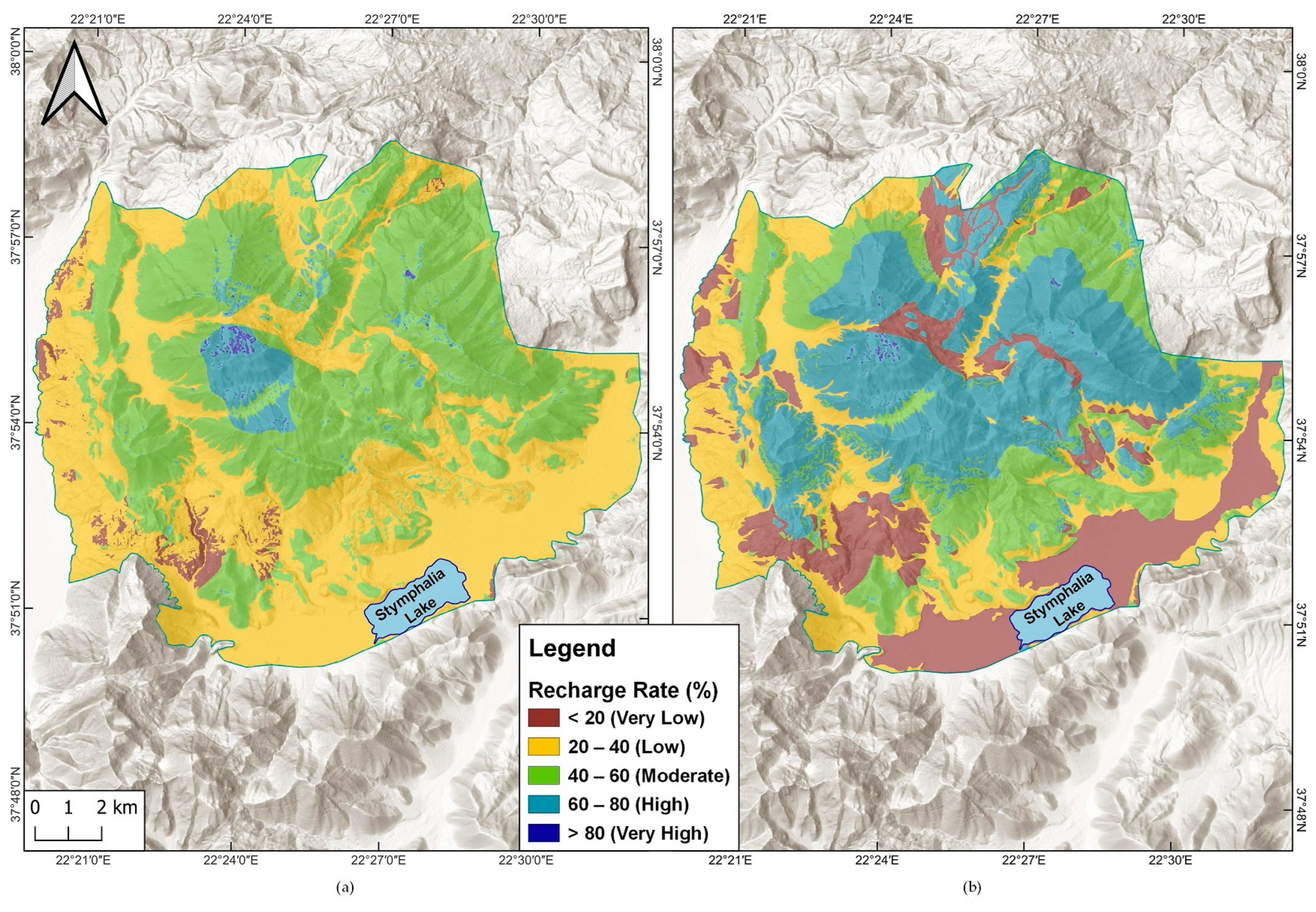
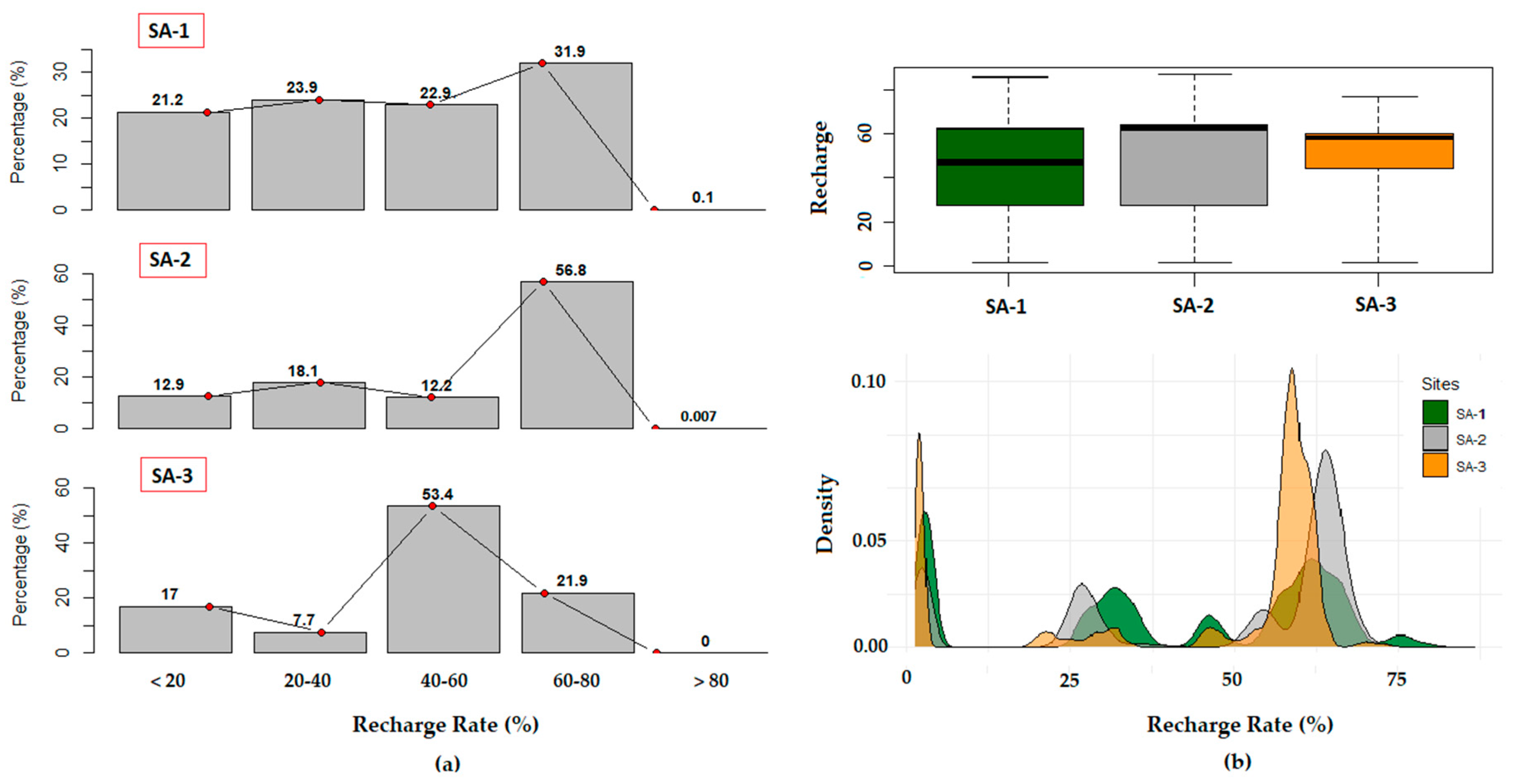
:The recharge of karst aquifers is significant for the effective management of groundwater resources, and its estimation should be tailored to accommodate their specific hydrogeological characteristics. This study provides a two-step methodological approach for the determination of karst aquifer recharge. Initially, mean annual recharge rates were estimated in the karst system of Ziria (Southern Greece) utilizing the APLIS and modified APLIS methods in order to decipher which was the most suitable version for recharge assessments. The results indicated similar mean recharge rate values at 42.7% and 41.4%, respectively, but significant differences in the spatial distribution. The modified methodology emerged as a more accurate and realistic approach, mainly due to the incorporation of permeability assessments. The final phase of the methodological approach involved the application of modified APLIS in two additional karst hydrosystems, Planitero and **romero, while a quantitative cross-comparison of the recharge rates was obtained for a deeper understanding of the factors controlling the groundwater recharge process. In Ziria, recharge rates exhibit a relatively uniform distribution throughout the area, with a median value of 46.7%. Conversely, in Planitero, High recharge rates (60–80%) occupy 56.8% of the surface, while in **romero, Moderate recharge rates (40–60%) dominate, representing 53.4% of the land coverage. These variations underscore the spatial heterogeneity of recharge within the karst systems, highlighting the importance of considering local geological and hydrological conditions in its assessments. The methodological approach of this study is flexible and can be adapted to different karst sites for the determination of recharge regimes, contributing to the alleviation of the groundwater depletion issue.
1. Introduction
Groundwater resources play an immense role in today’s society [1,2], since the universal demand for water supply is crucially increasing. The achievement of sustainable groundwater management is a pressing and often addressed issue due to its critical role in meeting basic human requirements [3]. The escalating need for freshwater, driven by global population growth and rapid urbanization, can cause groundwater reservoirs to face over-extraction and depletion, compromising their sustainability. Simultaneously, the issue of groundwater contamination has become extensive, with pollutants from agricultural runoff, industrial discharges, and improper waste disposal infiltrating aquifers.
Besides the ramifications that can arise from human activities, climatic causes may burden aquifers further, with dire impacts on their resources. In an era dominated by the pervasive effects of climate change, Earth’s hydrological cycle faces unprecedented challenges with shifts in temperature regimes, alterations in precipitation patterns, and intensified extreme weather events. These climate-induced changes can cause direct and indirect repercussions on global reserves [4], disrupt traditional recharge mechanisms, and intensify water scarcity. The increasing occurrence of droughts may lead to changes in the water balance, while rising global temperatures contribute to heightened evaporation rates, further amplifying water scarcity in vulnerable regions. The challenges facing groundwater resources have reached a critical juncture, potentially influencing their global distribution in the future. This underscores the imperative to address numerous water-related issues in a sustainable manner. Groundwater depletion constitutes a universal concern due to the unbalanced abstractions in comparison to the natural recharge. Obviously, the study of groundwater recharge is quite challenging, especially in karst aquifers.
At the forefront of hydrological environments, karst aquifers provide high-quality groundwater that is utilized either for drinking water supply or irrigation purposes. Climate-induced shifts can cause severe repercussions, leading to both a degradation in the availability and a compromise in the quality of water resources [5,6,7,8]. At the same time, with distinct characteristics and processes, karst aquifers are able to provide substantial amounts of groundwater, often resulting in their overexploitation [9,10], in order to meet the water demands of the constantly increasing population.
In Greece, there are numerous carbonate massifs distinguished by a diverse array of geological, geomorphological, and hydrogeological features, leading to a substantial variation in the degree of karstification across the country. Over the last decade, increasing research efforts have been directed towards the characterization, protection, and sustainable management of native karst aquifers, highlighting their significant value as water sources in Greece [11]. Up to 80% of the domestic karst systems are defined by good groundwater quality and quantity conditions, while qualitative issues are recorded mainly in coastal aquifers on islands, represented by a percentage of 5% [12].
The viable management of groundwater use requires the aversion of resource depletion. Recharge is one of the most significant parameters to be assessed in order to sustain the overall effective function of an exploited aquifer. Its approximation is essential to evaluating the maximum volume of water obtainable and to avoid overutilization [13]. Stable isotopes [14,15,16,17], lump and spatial models (e.g., Karstmod, VarKarst, Modflow-CFP), as well as index-based methods (e.g., APLIS, KARSTLOP), are widely used in order to determine the recharge process in karst environments [11,18,19,20,21,22,23,24]. Due to the heterogeneity of porosity and permeability that transcends karst aquifers [25,26] and significantly affects many of their qualities, the quantification of recharge constitutes a challenging task. The APLIS method was developed by Andreo et al. [27] and later modified by Marin [28] for the estimation of the recharge rate, expressed as a percentage of precipitation. Its parametric methodology is based on a geographic information system (GIS) and was developed specifically for carbonate aquifers under Mediterranean climatic conditions. APLIS has been implemented as well as compared to several other methods by numerous researchers [29,30,31,32], while many modifications have been made since to accommodate varying circumstances [33,34,35].
In this research, we applied a two-step-based methodological approach. Initially, the efficiency of APLIS and its modified version were compared in the karst system of Ziria in Southern Greece. The quantitative comparison of the two methods showed that modified APLIS is more suitable for Greek karst systems. The next step was the application of modified APLIS at two additional karst sites, Planitero and ** on the surface. To apply the method, the prior variables were developed as information layers within a Geographic Information System (GIS). Scoring values, ranging from 1 (minimum) to 10 (maximum), were then assigned according to the influence on recharge. All the map layers that were developed for the application of APLIS and modified APLIS in Ziria are depicted in Figure 3 and Figure 4.
The altitude map (A) was derived from a Digital Elevation Model (DEM) of the country, which in turn originated the slope map (P) in percent rise as required by the method. The elevation in the study area ranges from 600 to 2368 m.a.s.l., and the altitude was classified in 6 sequences of 300 m intervals. The slopes span from 0%, mainly in the polje of Stymphalia, to over 100% on the steep inclinations of Mount Ziria. The scoring of the first two variables was attributed so that the higher the altitude, the greater the recharge due to the increase in precipitation, and the greater the slope, the lower the recharge into the aquifer [27] (Table 1). In both scenarios, the altitude map and its corresponding values remain consistent. However, the classification and scoring of the slopes differ in APLIS and its modified version, with the latter presenting an additional class.
Considering the lithological aspect (L), there are seven major units dominating the site that all received scoring based on imputes from previous studies [47,48] and field observations. All the carbonates received high scores due to their karstification degree and tectonic stress. The limestones of Tripolis are considered to be more karstified than the Cretaceous limestones of Pindos because the latter often intervene with thin layers of radiolarite [48], therefore they were attributed the values 10 and 9, respectively. The Quaternary formations exhibit fluctuations due to changes in grain size and composition, along with the presence of argillaceous materials. The alluvial deposits in the polje, along with the outcrop at the north-eastern part of the area, received lower values than the rest. Finally, the conglomerates were attributed a significantly higher score than what is proposed by APLIS since they are considered to be karstic [49].
The areas of preferential infiltration (I) were located with remote sensing techniques, using aerial photographs and stereo pairs in Erdas Imagine 2010 software that enabled the three-dimensional representation of the system. Predominantly, these landforms were observed on the limestones of the Mountain, where the dominance of bare rocks and the absence of vegetation facilitated the clear delineation of such topographic depressions. On the Cretaceous limestones of Pindos, fields of dolines can be visually distinguished through satellite images and photographs, with no further assistance from remote sensing software. These landforms were collectively grouped rather than individually digitized, occupying, in such a way, a significant section of the limestones. Regarding this variable, APLIS provides only two rankings: a score of 10, which was attributed to the preferential infiltration landforms, and a score of 1, which was assigned to the rest of the system. Karst landforms that are filled with Quaternary sediments were assigned the lowest value (1), due to the method’s limited scoring options. In modified APLIS, an additional intermediate value of 5 was introduced. It was received by the polje and other karstic features that are covered by various materials, as well as attributed to all the carbonate outcrops, in order to be distinguished from the non-carbonate formations.
Due to the lack of specific soil data, the evaluation of the soil types (S) was based on the combination of information provided by different Soil maps [50,51,52]. A substantial section of the Mountain is characterized by exposed rock, devoid of soil and vegetation. Leptosols, assigned the highest value of 10, were designated as the soil type for limestone areas exhibiting minimal to no vegetation. Chromic luvisols were attributed to formations with denser vegetation, while calcareous regosols and fluvisols were predominantly assigned to Quaternary sediments. There are minimum scoring differences between the two methods.
For the estimation of the correction factor in modified APLIS, permeable formations such as carbonates, conglomerates, and most of the Quaternary deposits were identified with aquifer potential and were assigned the correction coefficient (Fh) 1. Impermeable formations like the metamorphic series and argillaceous sediments were assigned the value 0.1.
The reliability of the used data for the application of the methods is provided in the Supplementary Materials.
The scorings that were attributed to the rest of the variables for the application of modified APLIS are displayed in Table 2. For the estimation of the annual recharge rate and the creation of maps with its spatial distribution in both scenarios, the expressions of the original (1) and modified method (2) were utilized in ArcGIS 10.8 software:
R = (A + P + 3 × L + 2 × I + S)/0.9
R = [(A + P + 3 × L + 2 × I + S)/0.9] × Fh.
2.2.2. Application of Modified APLIS to Planitero and ** the final outcome. Modified APLIS distinguishes the infiltration landforms in three categories (1, 5, and 10), in contrast to the initial method, which has only two categories (1 and 10). Consequently, the category with a score of 5 is more representative for many formations of the studied hydrosystem compared to the initial score of 1. The greater extent of the lowest recharge rates is due to the correction factor (Fh) that was introduced in the modified methodology and empowers users to provide a more precise permeability assessment for the geological formations. Inevitably, in the final map, extreme values of recharge rates (e.g., <20% and 60–80%) cover a greater area. Consequently, the mean annual value of the recharge rate estimated by the modified APLIS is lower than the initial method. The permeability factor has notably addressed the limitation of the original method, which could not estimate recharge rates below 8%. In non-permeable formations, APLIS estimated recharge rates between 16% and 33%, as it relied solely on the minimum attributed values of the lithological parameter. High elevations, flattened slopes, and thin soil coverage, however, can increase the recharge rate of an impermeable formation that receives high scores in all three categories.
Other researchers have also compared the two adaptations of the method. Espinoza et al. [34] applied APLIS and its modified version to a fractured karst aquifer in Peru, estimating the mean annual recharge rates at 48% and 24%, respectively, and emphasizing the key role of the correction factor in this differentiation. In another study, AHP, APLIS, and modified APLIS were implemented to evaluate the infiltration potential of the Roein Esfarayen Basin in Iran [54], with modified APLIS demonstrating the highest correlation coefficient (0.85) among the three methods, underscoring its efficacy in capturing and describing the complexities of recharge dynamics. Overall, the methodology behind modified APLIS consistently produces a more coherent and realistic portrayal of the recharge rate.
3.2. Statistical and Spatial Comparison of the Annual Recharge Rates in All Three Karst Sites Utilizing Modified APLIS
The estimation of the annual recharge rate was conducted using modified APLIS in both Planitero and ** the spatial distribution of annual recharge within a given area, it exhibits a limitation in its capacity to estimate its temporal variability. This limitation stems from the inherent nature of the method, which predominantly focuses on spatial aspects, neglecting the intricate temporal dynamics of recharge processes and providing averaged annual values of recharge rates. Recharge in karst aquifers is not a constant phenomenon but can vary significantly over time, influenced by factors such as seasonal variations in precipitation, land use changes, and climate fluctuations. Kirn et al. [55] extended the spatial dimension of the method to include the aspect of time variance and concluded that APLIS tends to overestimate recharge in dry years and underestimate it in wet years.
APLIS is a promising method for assessing the mean annual recharge that has been applied to several karst aquifers under Mediterranean climatic conditions, yielding satisfactory results. Given the intricate nature of karst systems and the challenges associated with verifying recharge assessments, the adoption of a multi-method approach is essential. In the future, further research will be conducted in order to strengthen the premise of this ongoing project. A comparison of APLIS’ results with lump simulation models is strongly suggested. The implementation of advanced modeling at the study sites will provide a more holistic view of recharge, aid in error reduction, and enhance the reliability of findings associated with APLIS as an individual technique. Sensitivity analyses and robustness testing will be conducted in order to assess the potential impact of varying the parameters on the method’s results, and tectonic lineaments will be introduced as possible infiltration landforms. Discharge measurements and hydrograph analysis from the front of springs in the karst system of Ziria will contribute to the verification of the results. The determination of recharge rates on a hydrogeological basin scale is valuable for the understanding of karst aquifer functions. Nevertheless, we strongly suggest comparing the results with the hydrological component of infiltration at the hydrological basin scale [56]. This approach could better determine underground runoff, which is critically important in the groundwater extraction process for the sustainable water supply of the community. Future research will incorporate hydro-chemical data, high-frequency discharge measurements, and isotopic data from groundwater and rain.
4. Conclusions
The two-step methodological approach that was applied in this study revealed that the geological structure influences the recharge rates of a karst aquifer. The conclusions are summarized below:
- -
- The discretization of formation permeability increases the reliability of recharge rate determinations.
- -
- Modified APLIS, compared to the initial method, provided extended zones with Very Low (<20%) and High (60–80%) recharge rates.
- -
- The modified APLIS method estimated a relatively lower recharge rate (41.4%) compared to the initial method (42.7%) in Ziria, mainly due to the imported parameter of permeability.
- -
- The cross-comparison of the results between the different karst systems revealed that the coverage of karst aquifers determines the recharge rate.
- -
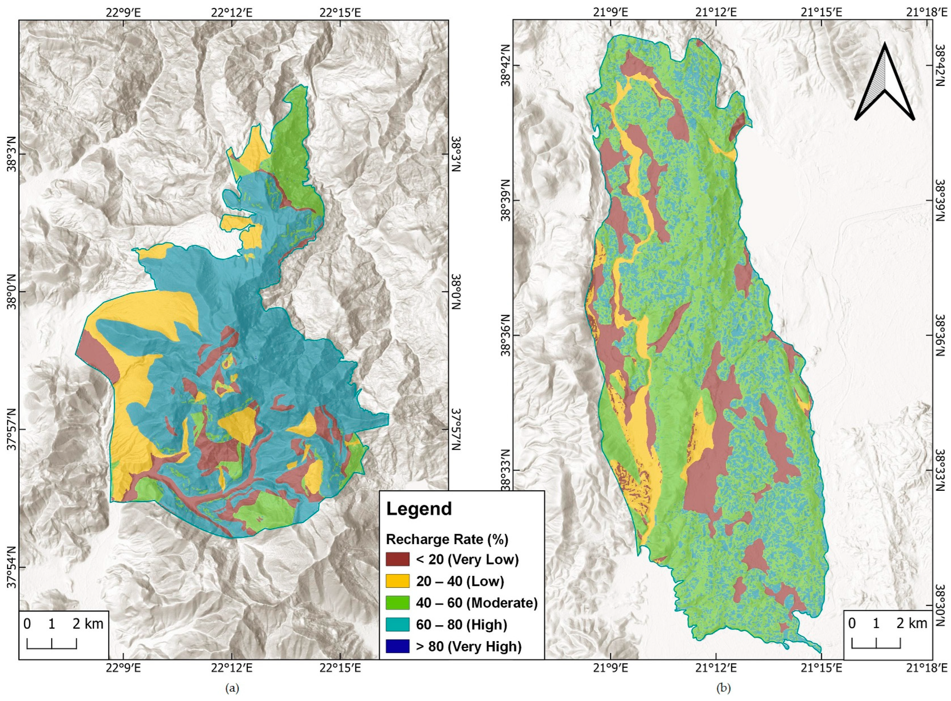
- The highest mean recharge rate was estimated in the Planitero karst system (48.6%) due to the absence of coverage of the karstified rocks.
This study revealed that modified APLIS constitutes a flexible method for the estimation of karst aquifer recharge rates in the Mediterranean region. The quantification and spatial distribution of mean annual recharge rates can increase the accuracy of water balance estimations, which is a fundamental step for sustainable groundwater resource management.
Supplementary Materials
The following supporting information can be downloaded at: https://mdpi.longhoe.net/article/10.3390/w16040568/s1, Reliability of used data.
Author Contributions
Conceptualization, E.-A.N. and E.Z.; data curation and processing, E.-A.N., P.T. and K.P.; software, E.-A.N., P.T. and K.P.; writing-original draft preparation, E.-A.N.; writing–review and editing, E.-A.N. and E.Z.; supervision, E.Z.; funding acquisition, E.-A.N. All authors have read and agreed to the published version of the manuscript.
Funding
Part of the research work was supported by the Hellenic Foundation for Research and Innovation (HFRI) under the HFRI PhD Fellowship grant (Fellowship Number: 684).
Data Availability Statement
The presented data are available on request from the corresponding author.
Acknowledgments
A section of this study has been presented at the 12th International Hydrogeological Conference held in Nicosia, Cyprus, in 2022.
Conflicts of Interest
The authors declare no conflict of interest.
References
- Wada, Y.; Van Beek, L.P.H.; Van Kempen, C.M.; Reckman, J.W.T.M.; Vasak, S.; Bierkens, M.F.P. Global depletion of groundwater resources. Geophys. Res. Lett. 2010, 37, L20402. [Google Scholar] [CrossRef]
- Scanlon, B.R.; Fakhreddine, S.; Rateb, A.; de Graaf, I.; Famiglietti, J.; Gleeson, T.; Grafton, R.Q.; Jobbagy, E.; Kebede, S.; Kolusu, S.R.; et al. Global water resources and the role of groundwater in a resilient water future. Nat. Rev. Earth Environ. 2023, 4, 87–101. [Google Scholar] [CrossRef]
- Mishra, B.K.; Kumar, P.; Saraswat, C.; Chakraborty, S.; Gautam, A. Water Security in a Changing Environment: Concept, Challenges and Solutions. Water 2021, 13, 490. [Google Scholar] [CrossRef]
- Taylor, R.G.; Scanlon, B.; Döll, P.; Rodell, M.; Van Beek, R.; Wada, Y.; Longuevergne, L.; Leblanc, M.; Famiglietti, J.S.; Edmunds, M.; et al. Ground water and climate change. Nat. Clim. Chang. 2012, 3, 322–329. [Google Scholar] [CrossRef]
- Jia, Z.; Zang, H.; Zheng, X.; Xu, Y. Climate Change and Its Influence on the Karst Groundwater Recharge in the **ci Spring Region, Northern China. Water 2017, 9, 267. [Google Scholar] [CrossRef]
- Lukač Reberski, J.; Rubinić, J.; Terzić, J.; Radišić, M. Climate Change Impacts on Groundwater Resources in the Coastal Karstic Adriatic Area: A Case Study from the Dinaric Karst. Nat. Resour. Res. 2020, 29, 1975–1988. [Google Scholar] [CrossRef]
- Klaas, D.K.S.Y.; Imteaz, M.A.; Sudiayem, I.; Klaas, E.M.E.; Klaas, E.C.M. Assessing climate changes impacts on tropical karst catchment: Implications on groundwater resource sustainability and management strategies. J. Hydrol. 2020, 582, 124426. [Google Scholar] [CrossRef]
- Sivelle, V.; Jourde, H.; Bittner, D.; Mazzilli, N.; Tramblay, Y. Assessment of the relative impacts of climate changes and anthropogenic forcing on spring discharge of a Mediterranean karst system. J. Hydrol. 2021, 598, 126396. [Google Scholar] [CrossRef]
- Taheri, K.; Taheri, M.; Parise, M. Impact of intensive groundwater exploitation on an unprotected covered karst aquifer: A case study in Kermanshah Province, western Iran. Environ. Earth Sci. 2016, 75, 1221. [Google Scholar] [CrossRef]
- Zhang, Z.; Xu, Y.; Zhang, Y.; Guo, L.; Wang, Z.; Zheng, Q. Impact of groundwater overexploitation on karst aquifer and delineation of the critical zones: Case study of **ci spring in Shanxi, China. Carbonates Evaporites 2022, 37, 68. [Google Scholar] [CrossRef]
- Kazakis, N.; Chalikakis, K.; Mazzilli, N.; Ollivier, C.; Manakos, A.; Voudouris, K. Management and research strategies of karst aquifers in Greece: Literature overview and exemplification based on hydrodynamic modelling and vulnerability assessment of a strategic karst aquifer. Sci. Total Environ. 2018, 643, 592–609. [Google Scholar] [CrossRef]
- Voudouris, K.S. Status and codification of karst aquifer systems in Greece. Bull. Geol. Soc. Greece 2021, 57, 23–51. [Google Scholar] [CrossRef]
- Seiler, K.P.; Gat, J.R. Groundwater Recharge from Run-Off, Infiltration and Percolation; Springer: Dordrecht, The Netherlands, 2007. [Google Scholar]
- Sappa, G.; Vitale, S.; Ferranti, F. Identifying Karst Aquifer Recharge Areas using Environmental Isotopes: A Case Study in Central Italy. Geosciences 2018, 8, 351. [Google Scholar] [CrossRef]
- Dar, F.A.; Jeelani, G.; Perrin, J.; Ahmed, S. Groundwater recharge in semi-arid karst context using chloride and stable water isotopes. Groundw. Sustain. Dev. 2021, 14, 100634. [Google Scholar] [CrossRef]
- Iacurto, S.; Grelle, G.; De Filippi, F.M.; Sappa, G. Karst Recharge Areas Identified by Combined Application of Isotopes and Hydrogeological Budget. Water 2021, 13, 1965. [Google Scholar] [CrossRef]
- Petitta, M.; Banzato, F.; Lorenzi, V.; Matani, E.; Sbarbati, C. Determining recharge distribution in fractured carbonate aquifers in central Italy using environmental isotopes: Snowpack cover as an indicator for future availability of groundwater resources. Hydrogeol. J. 2022, 30, 1619–1636. [Google Scholar] [CrossRef]
- Radulovic, M.; Stevanovic, Z.; Radulovic, M. A new approach in assessing recharge of highly karstified terrains-Montenegro case studies. Environ. Earth Sci. 2012, 65, 2221–22230. [Google Scholar] [CrossRef]
- Hartmann, A.; Barbera, J.A.; Lange, J.; Andreo, B.; Weiler, M. Progress in the hydrologic simulation of time variant recharge areas of karst systems—Exemplified at a karst spring in Southern Spain. Adv. Water Resour. 2013, 54, 149–160. [Google Scholar] [CrossRef]
- Malard, A.; Sinreich, M.; Jeannin, P.-Y. A novel approach for estimating karst groundwater recharge in mountainous regions and its application in Switzerland. Hydrol. Process. 2016, 30, 2153–2166. [Google Scholar] [CrossRef]
- Hosseini, S.M.; Ataie-Ashtiani, B.; Simmons, C.T. Spring hydrograph simulation of karstic aquifers: Impacts of variable recharge area, intermediate storage and memory effects. J. Hydrol. 2017, 552, 225–240. [Google Scholar] [CrossRef]
- Jukić, D.; Denić-Jukić, V.; Lozić, A. An alternative method for groundwater recharge estimation in karst. J. Hydrol. 2021, 600, 126671. [Google Scholar] [CrossRef]
- Messerschmid, C.; Aliewi, A. Spatial distribution of groundwater recharge, based on regionalised soil moisture models in Wadi Natuf karst aquifers, Palestine. Hydrol. Earth Syst. Sci. 2022, 26, 1043–1061. [Google Scholar] [CrossRef]
- Berthelin, R.; Olarinoye, T.; Rinderer, M.; Mudarra, M.; Demand, D.; Scheller, M.; Hartmann, A. Estimating karst groundwater recharge from soil moisture observations—A new method tested at the Swabian Alb, southwest Germany. Hydrol. Earth Syst. Sci. 2023, 27, 385–400. [Google Scholar] [CrossRef]
- White, W.B. Conceptual models for karstic aquifers. In Karst Modeling; Palmer, A.N., Palmer, M.V., Sasowsky, I.D., Eds.; The Karst Waters Institute: Charles Town, WV, USA, 1999; pp. 11–16. [Google Scholar]
- Bakalowicz, M. Karst groundwater: A challenge for a new resources. Hydrogeol. J. 2005, 13, 148–160. [Google Scholar] [CrossRef]
- Andreo, B.; Vías, J.; Durán, J.J.; Jiménez, P.; López-Geta, J.A.; Carrasco, F. Methodology for groundwater recharge assessment in carbonate aquifers: Application to pilot sites in southern Spain. Hydrogeol. J. 2008, 16, 911–925. [Google Scholar] [CrossRef]
- Marín, A.I. Los Sistemas de Información Geográfica Aplicados a la Evaluación de Recursos Hídricos y a la Vulnerabilidad a la Contaminación de Acuíferos Carbonatados: Caso de la Alta Cadena (Provincia de Málaga). Ph.D. Thesis, University of Malaga, Malaga, Spain, 2009. [Google Scholar]
- Zagana, E.; Tserolas, P.; Floros, G.; Katsanou, K.; Andreo, B. First outcomes from groundwater recharge estimation in evaporate aquifer in Greece with the use of APLIS method. In Advances in the Research of Aquatic Environment; Lambrakis, N., Stournaras, G., Katsanou, K., Eds.; Springer: Berlin/Heidelberg, Germany, 2011; Volume 2, pp. 89–96. [Google Scholar]
- Martos-Rosillo, S.; Rodriguez-Rodriguez, M.; Pedrera, A.; Cruz- SanJulian, J.J.; Rubio, J.C. Groundwater recharge in semi-arid carbonate aquifers under intensive use: The Estepa Range aquifers (Seville, southern Spain). Environ. Earth Sci. 2013, 70, 2453–2468. [Google Scholar] [CrossRef]
- Hartmann, A.; Mudarra, M.; Andreo, B.; Marín, A.; Wagener, T.; Lange, J. Modeling spatiotemporal impacts of hydroclimatic extremes on groundwater recharge at a Mediterranean karst aquifer. Water Resour. Res. 2014, 50, 6507–6521. [Google Scholar] [CrossRef]
- Mudarra, M.; Hartmann, A.; Andreo, B. Combining Experimental Methods and Modeling to Quantify the Complex Recharge Behavior of Karst Aquifers. Water Resour. Res. 2019, 55, 1384–1404. [Google Scholar] [CrossRef]
- Farfán, H.; Corvea, J.L.; De Bustamante, I. Sensitivity Analysis of ALPIS Method to Compute Spatial Variability of Karst Aquifers Recharge at the national Park of Viñales (Cuba). In Advances in Research in Karst Media; Andreo, B., Carrasco, F., Durán, J.J., LaMoreaux, J.W., Eds.; Springer: Berlin/Heidelberg, Germany, 2010; pp. 19–24. [Google Scholar]
- Espinoza, K.; Marina, M.; Fortuna, J.H.; Altamirano, F. Comparison of the APLIS and Modified-APLIS methods to estimate the recharge in fractured karst aquifer, Amazonas, Peru. In Hydrogeological and Environmental Investigations in Karst Systems; Andreo, B., Carrasco, F., Durán, J.J., Jiménez, P., LaMoreaux, J.W., Eds.; Springer: Berlin/Heidelberg, Germany, 2015; Volume 1, pp. 83–90. [Google Scholar]
- Alem, H.; Soudejani, A.E.; Farmanieh, S.N. Ground water recharge assessment in the karst aquifers of North Khorasan, Iran using APLIS method. Acta Carsologica 2017, 46, 283–294. [Google Scholar] [CrossRef]
- Special Secretariat for Water. Management Plans of Northern Peloponnese River Basin District; Ministry of Environment and Energy: Athens, Greece, April 2013.
- WFD. Directive 2000/60/EC of the European Parliament and of the Council of 23 October 2000 establishing a framework for Community action in the field of water policy. Off. J. Eur. Communities 2000, L 327, 1–72. [Google Scholar]
- De Wever, P.; Dercourt, J.; Fleury, J.J. Kandhila Sheet. 1:50.000; Institute of Geology and Mineral Exploration: Athens, Greece, 1982. [Google Scholar]
- Tataris, A.; Maragoudakis, N.; Kounis, G.; Christodoulou, G.; Tsaila-Monopoli, S. Nemea Sheet. 1:50.000; Institute for Geology and Subsurface Research: Athens, Greece, 1970. [Google Scholar]
- Hötzl, H.; Merkler, G.; Reichert, B.; Röckel, T.; Watzel, R. Interpretation of geophysical measurements in the poljes of Alea-Scotini and Stymfalia. In Karst Hydrogeology of the Central and Eastern Peloponnesus (Greece), Proceedings of the 5th International Symposium on Underground Water Tracing, Athens, Greece, 22–27 September 1986; Steirische Beiträge zur Hydrogeologie; Morfis, A., Zojer, H., Eds.; Springer: Cham, Switzerland, 1986; Volumes 37/38, pp. 44–54. [Google Scholar]
- Meilliez, F.; Flament, J.M.; De Wever, P.; Dercourt, J.; Fleury, J.J. Dhafni Sheet. 1:50.000; Institute of Geology and Mineral Exploration: Athens, Greece, 1978. [Google Scholar]
- Psonis, K.; Skourtsi-Koroneou, V.; Carras, N.; Varti-Mataragha, M. Aeghion Sheet. 1:50.000; Institute of Geology and Mineral Exploration: Athens, Greece, 2013. [Google Scholar]
- Psonis, K.; Tsapralis, V.; Skourtsi-Koroneou, V. Astakos Sheet. 1:50.000; Institute of Geology and Mineral Exploration: Athens, Greece, 1986. [Google Scholar]
- Kouris, C.; Tsaila-Monopolis, S. Echinades Sheet. 1:50.000; Institute of Geology and Mineral Exploration: Athens, Greece, 1989. [Google Scholar]
- Gofa, F.; Mamara, A.; Anadranistakis, M.; Flocas, H. Develo** gridded climate data sets of precipitation for Greece based on homogenized time series. Climate 2019, 7, 68. [Google Scholar] [CrossRef]
- Kakavas, M.; Nikolakopoulos, K.G.; Kyriou, A.; Zagana, H. Assessment of freely available DSMs for automatic karst feature detection. Arab. J. Geosci. 2018, 11, 388. [Google Scholar] [CrossRef]
- Morfis, A.; Zojer, H. (Eds.) Karst Hydrogeology of the Central and Eastern Peloponnesus (Greece), Proceedings of the 5th International Symposium on Underground Water Tracing, Athens, Greece, 22–27 September 1986; Steirische Beiträge zur Hydrogeologie; Springer: Cham, Switzerland, 1986; Volumes 37/38, pp. 1–301. [Google Scholar]
- Zervogiannis, G. Final Hydrogeological Study for the Reformation of the Stymphalian Springs in the Prefecture of Corinth; Ministry of Agriculture: Athens, Greece, 1991. (In Greek)
- Röckel, T.; Hötzl, H. Polje of Stymfalia. In Karst Hydrogeology of the Central and Eastern Peloponnesus (Greece), Proceedings of the 5th International Symposium on Underground Water Tracing, Athens, Greece, 22–27 September 1986; Steirische Beiträge zur Hydrogeologie; Morfis, A., Zojer, H., Eds.; Springer: Cham, Switzerland, 1986; Volumes 37/38, pp. 127–152. [Google Scholar]
- Katakouzinos, D.S. Soil Map of Greece. 1:1.000.000; Ministry of Agriculture: Athens, Greece, 1967.
- FAO; UNESCO. Soil Map of the World. 1:5.000.000; UNESCO: Paris, France, 1978. [Google Scholar]
- European Soil Bureau Network. Soil Atlas of Europe; European Commission: Luxembourg, 2005; p. 128.
- Voudouris, K.; Panagopoulos, A.; Markantonis, K. Hydrological balance and possibilities of sustainable water resources management in Stimfalia basin (prefecture of Korinthos). In Proceedings of the 6th Pan-Hellenic Geographical Conference of the Hellenic Geographical Society, Thessaloniki, Greece, 3–6 October 2002; Volume 2, pp. 327–334. [Google Scholar]
- Rad, M.M.; Mokhtari, L.G.; Bahrami, S.; Asadi, M.Z. Assessment of infiltration potential using the AHP, APLIS and modified APLIS models (Case study: Esfarayen Basin). Quant. Geomorphol. Res. 2018, 7, 117–139. [Google Scholar]
- Kirn, L.; Mudarra, M.; Marín, A.; Andreo, B.; Hartmann, A. Improved assessment of groundwater recharge in a Mediterranean karst region: Andalusia, Spain. In EuroKarst 2016, Neuchâtel; Renard, P., Bertrand, C., Eds.; Springer: Cham, Switzerland, 2017; pp. 117–125. [Google Scholar]
- Malov, A.I. Groundwater resources of the White Sea Basin (NW Russia). In The Arctic: Current Issues and Challenges; Malov, A.I., Pokrovsky, O.S., Kirpotin, S.N., Eds.; Nova Science Publishers: New York, NY, USA, 2020; pp. 239–266. [Google Scholar]
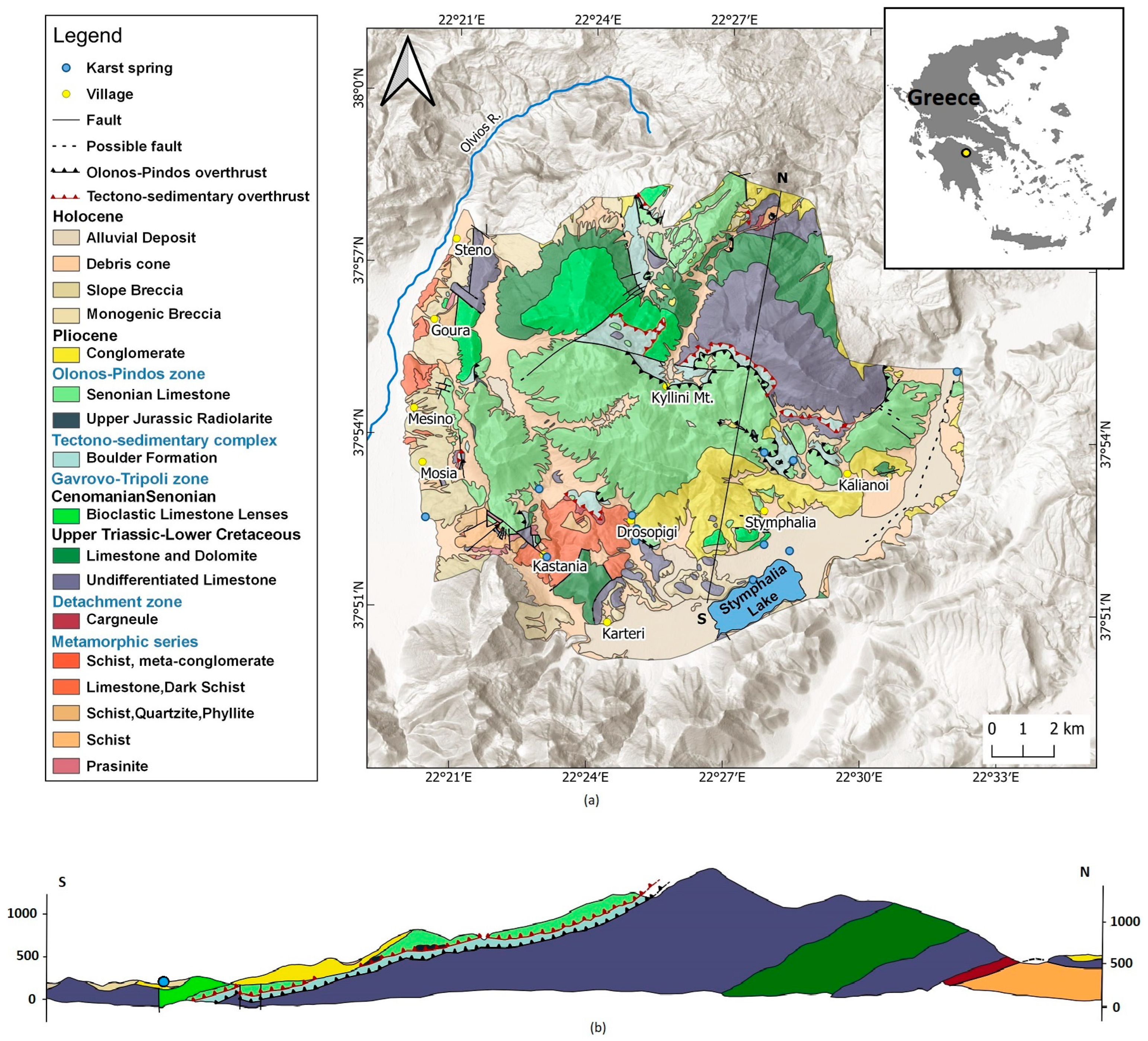
Figure 1.
(a) Geological setting of the karst groundwater system of Ziria (modified by [38,39]), (b) Geological cross section (modified by [38]).

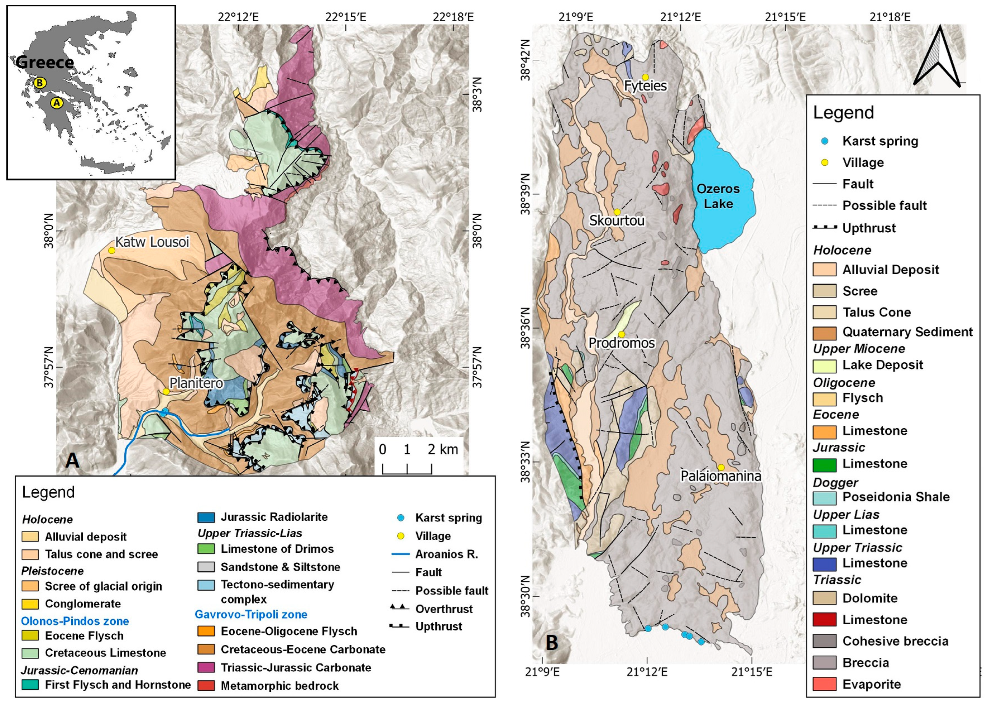
Figure 2.
Geological setting of (A) Planitero (modified by [38,41,42]) and (B) **romero (modified by [43,44]).

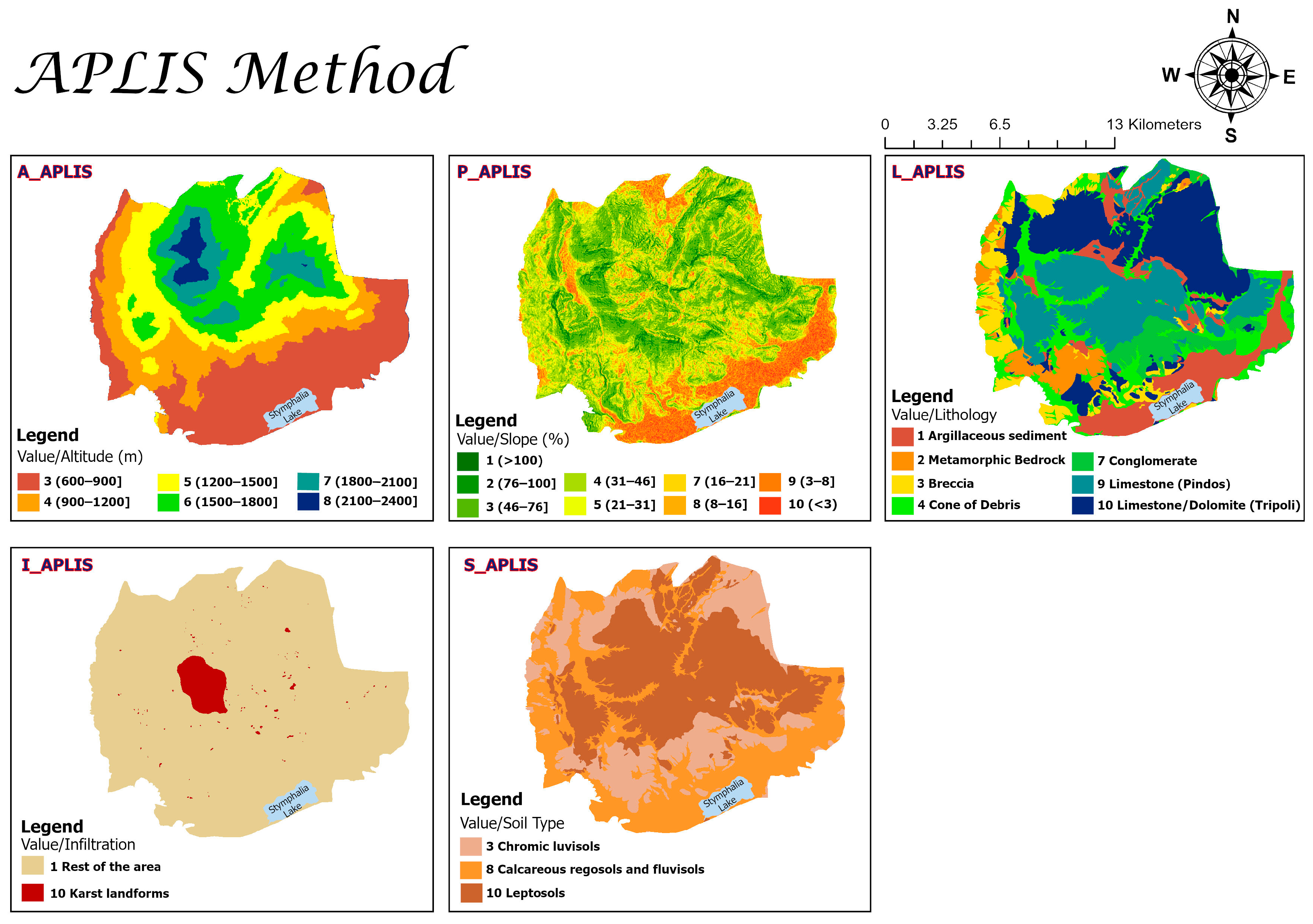
Figure 3.
Maps of all the variables developed for the application of the APLIS method.

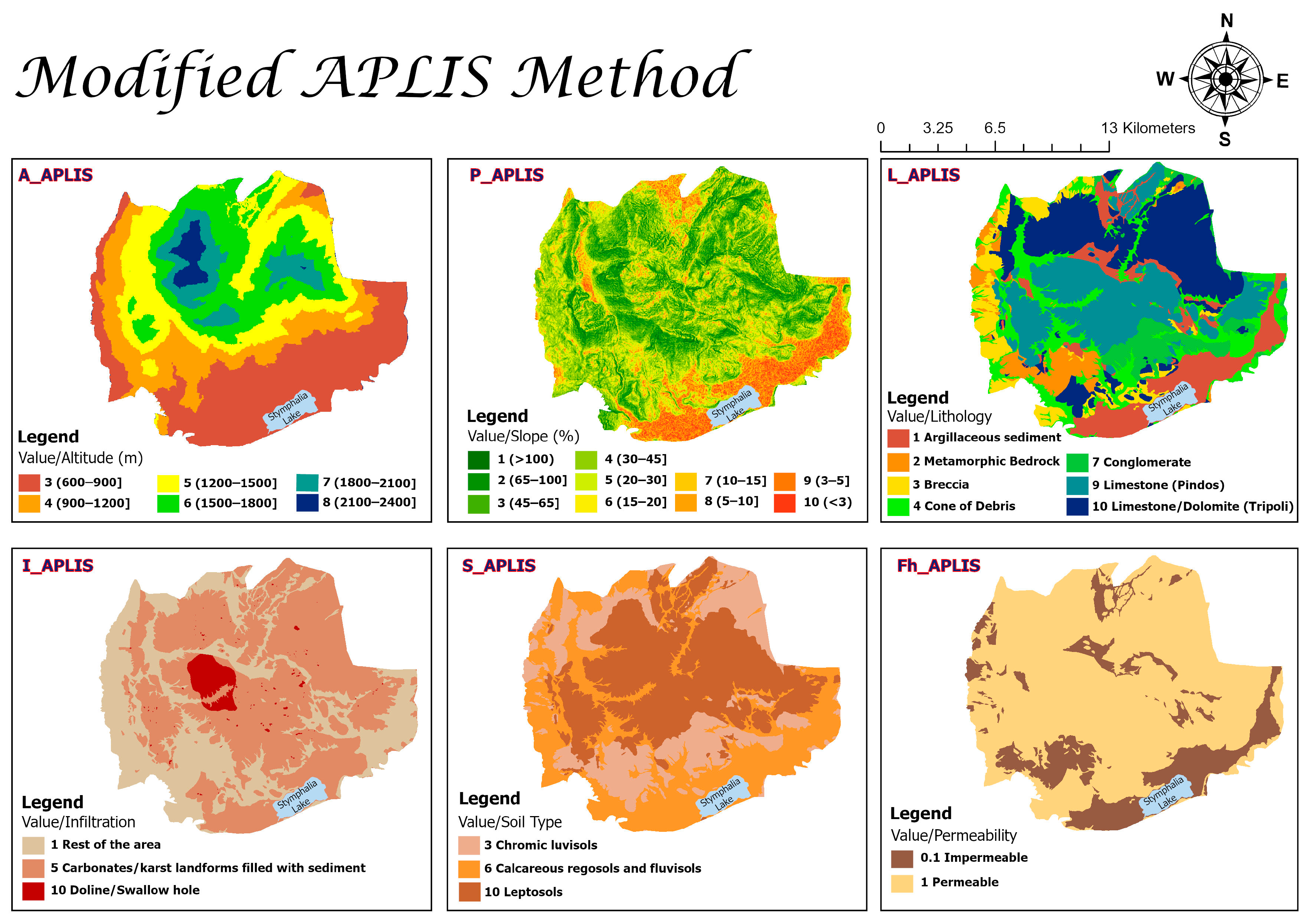
Figure 4.
Maps of all the variables developed for the application of modified APLIS.

Figure 5.
Spatial distribution of the annual recharge rate (%) in the karst system of Ziria utilizing (a) the APLIS method and (b) modified APLIS.
Figure 5.
Spatial distribution of the annual recharge rate (%) in the karst system of Ziria utilizing (a) the APLIS method and (b) modified APLIS.

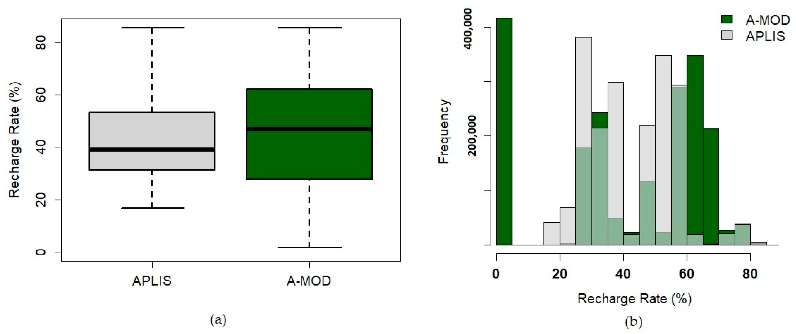
Figure 6.
(a) Data visualization and comparison with boxplots; (b) Histogram with data distribution and range of values (A-MOD represents modified APLISand the light green color portrays areas of overlap).
Figure 6.
(a) Data visualization and comparison with boxplots; (b) Histogram with data distribution and range of values (A-MOD represents modified APLISand the light green color portrays areas of overlap).

Figure 7.
Annual recharge rate estimated with modified APLIS (a) in Planitero, Northern Peloponnese, and (b) in **romero, Western Greece.
Figure 7.
Annual recharge rate estimated with modified APLIS (a) in Planitero, Northern Peloponnese, and (b) in **romero, Western Greece.

Figure 8.
(a) Surface coverage of each recharge class in Ziria (SA-1), Planitero (SA-2), and **romero (SA-3), and (b) Boxplots illustrating the distribution of the annual recharge rate data in SA-1, SA-2, and SA-3 (top) and a density plot (bottom) showing its allocation between the sites.
Figure 8.
(a) Surface coverage of each recharge class in Ziria (SA-1), Planitero (SA-2), and **romero (SA-3), and (b) Boxplots illustrating the distribution of the annual recharge rate data in SA-1, SA-2, and SA-3 (top) and a density plot (bottom) showing its allocation between the sites.


Table 1.
Scoring of the Altitude (A) and Slope (P) variables for the karst system of Ziria.
| Scoring | 1 | 2 | 3 | 4 | 5 | 6 | 7 | 8 | 9 | 10 |
|---|---|---|---|---|---|---|---|---|---|---|
| Altitude (m) | - | - | (600–900] | (900–1200] | (1200–1500] | (1500–1800] | (1800–2100] | (2100–2400] | - | - |
| Slope (%) | ||||||||||
| APLIS | >100 | (76–100] | (46–76] | (31–46] | (21–31] | - | (16–21] | (8–16] | (3–8] | <3 |
| Modified APLIS | >100 | (65–100] | (45–65] | (30–45] | (20–30] | (15–20] | (10–15] | (5–10] | (3–5] | <3 |
Table 2.
Scoring values of the variables L, I, and S for the application of modified APLIS in Ziria.
Table 2.
Scoring values of the variables L, I, and S for the application of modified APLIS in Ziria.
| Lithology (L) | Scoring | Infiltration Landforms (I) | Scoring |
|---|---|---|---|
| Argillaceous sediment | 1 | Rest of the area | 1 |
| Metamorphic bedrock | 2 | Carbonates/karstic landforms filled with sediment | 5 |
| Breccia | 3 | Doline/Swallow hole | 10 |
| Cone of Debris | 4 | Soil Type (S) | Scoring |
| Conglomerate | 7 | Chromic luvisols | 3 |
| Cretaceous Limestone (Pindos) | 9 | Calcareous regosols and fluvisols | 6 |
| Limestone/Dolomite (Tripoli) | 10 | Leptosols | 10 |
Table 3.
Assigned values to the variables of the modified APLIS for Planitero.
| Lithology (L) | Scoring | Infiltration Landforms (I) | Scoring |
|---|---|---|---|
| Flysch/Argillaceous sediment | 1 | Rest of the area | 1 |
| Metamorphic bedrock | 2 | Carbonates/karstic landforms filled with sediment | 5 |
| Quaternary deposits | 3 | Doline | 10 |
| Talus Cone/Scree | 4 | Soil Type (S) | Scoring |
| Chromic luvisols | 3 | ||
| Carbonates (Pindos Zone) | 9 | Calcareous regosols and fluvisols | 6 |
| Carbonates (Tripolis Zone) | 10 | Leptosols | 10 |
Table 4.
Assigned values to the variables of modified APLIS for **romero—modified from [29].
Table 4.
Assigned values to the variables of modified APLIS for **romero—modified from [29].
| Lithology (L) | Scoring | Infiltration Landforms (I) | Scoring |
|---|---|---|---|
| Quaternary Sediment | 1 | Rest of the area | 1 |
| Evaporites/non karstified limestones | 2 | Karstified Limestone/Breccia | 5 |
| Talus Cone/Scree | 3 | Doline | 10 |
| Alluvial Deposit | 4 | Soil Type (S) | Scoring |
| Fluvisols | 6 | ||
| Dolomite | 7 | Calcareous Lithosols | 6 |
| Triassic Limestone/Breccia | 9 | Leptosols | 10 |
Disclaimer/Publisher’s Note: The statements, opinions and data contained in all publications are solely those of the individual author(s) and contributor(s) and not of MDPI and/or the editor(s). MDPI and/or the editor(s) disclaim responsibility for any injury to people or property resulting from any ideas, methods, instructions or products referred to in the content. |
© 2024 by the authors. Licensee MDPI, Basel, Switzerland. This article is an open access article distributed under the terms and conditions of the Creative Commons Attribution (CC BY) license (https://creativecommons.org/licenses/by/4.0/).