2.1. Study Area
Zhangqiu District is located in the eastern region of **an City, with an area of 1719 km
2. It is connected to the Zhoucun District of Zibo City in the east and the Daiyue District of Tai an City in the south. The traffic in the area is convenient. Zhangqiu District is located on the northern foot of Taiyi Mountain, bordering on the North China Plain [
24]. The Great Wall Ridge stretches to the south, and Changbai Mountain stands to the east. The terrain is tilted from southeast to northwest and from south to north, followed by mountains, hills, plains and depressions. It is a continental climate in the warm temperate monsoon region. The four seasons are distinct, and the rain and heat occur in the same season. Spring is dry and windy, summer rainfall is concentrated, autumn is mild and cool and winter snow is less dry and cold [
25]. The accident site is located in the surrounding area of Shanggao Village Coal Mine in Zhangqiu City, Shandong Province.
The southern part of the Tuozhangqiu belongs to the Luxi uplift, and the northern part belongs to the Jiyang sag. The geological structure is dominated by monoclinic strata, with a strike of 60° NW and a dip angle of 7° to 13°. The strata exposed in the study area are mainly Quaternary and Ordovician, and the remaining strata are less or not exposed [
26]. The sedimentary sequence of each geological age is the Archean metamorphic rock series, the Paleozoic sedimentary rock series, the Mesozoic sedimentary rock series and the Cenozoic sedimentary rock series [
27]. The larger synclines in the study area include the Wenzu–Bucun syncline and the **langgou syncline. The faults and fissures are mostly NNW and NNE, and the larger faults are the Wenzu fault, Yuwangshan fault, Ganquan fault, Songjiazhuang fault and so on.
The hydrogeological unit of the study area belongs to the upstream runoff area of the Mingshui spring basin. The piedmont zone in the northern part of the study area is mainly loose rock pore water. The main aquifer of carbonate rock fissure karst water is the Wuyangshan Formation, which is mainly located in the south and exposed to the surface. The karst fissure water of clastic rock and carbonate rock is mainly coal-bearing strata. The bedrock weathering fissure water is mainly distributed in the northern part of the study area. Artificial mining discharge is an important discharge form of karst water in the area. Because the area is mainly a monoclinic structure, confined groundwater is often formed in the continuous distribution section of sandstone.
2.2. Sampling and Analysis
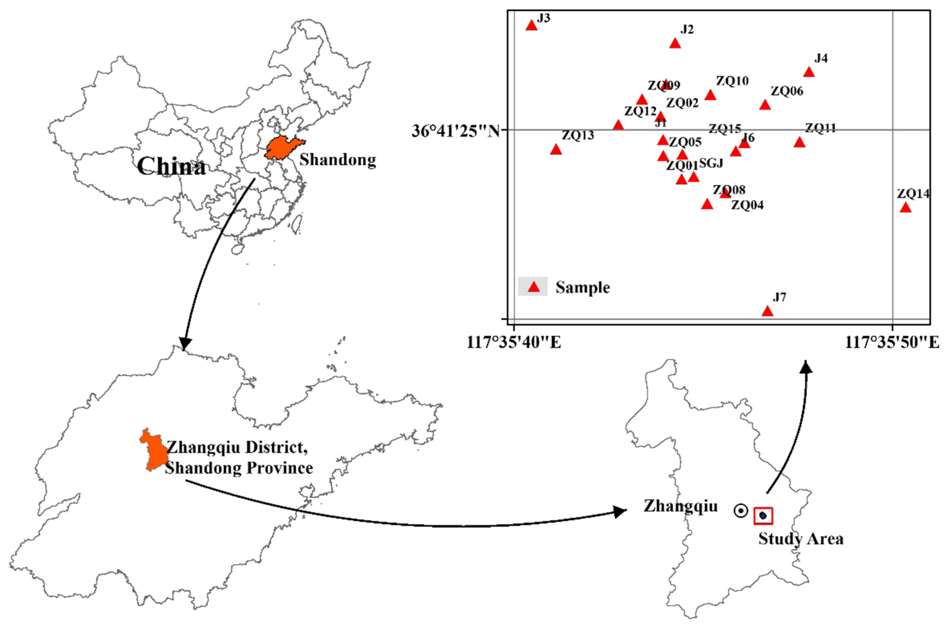
Combined with the geological structure, environment and human activities, according to ‘the technical guidelines for the sampling of volatile organic compounds in soil and groundwater’ (HJ 1019-2019), ‘Groundwater environment investigation and evaluation work guide’, ‘Groundwater environment monitoring technical specification’ (HJ 164-2020), the point layout is required, 22 monitoring wells are set up and a total of 22 groups of groundwater samples are collected. The groundwater sampling points are shown in
Figure 1. Taking the accident well as the center, 22 monitoring wells were taken around the accident well. Clean, dry polyethylene plastic bottles were used to take water samples, and the sample pretreatment was completed within 24 h.
Inductively coupled plasma mass spectrometry (ICP-MS) (ICP-MS, Thermo X Series 2, Waltham, MA, USA) is used to detect heavy metal ions in groundwater samples. Volatile organic compounds in water samples are detected according to ‘Determination of volatile organic compounds in water quality-Purge and trap/gas chromatography-mass spectrometry’ (HJ 639-2012). Quality assurance and control are carried out by means of method blank and matrix addition. We use a purge and trap device (ATOMX-XYZ 1090L0429, Mason, OH, USA), and the chromatographic mass spectrometer is Agilent 8890-5977B (Agilent, Santa Clara, CA, USA) [
28]. All tests are performed in triplicate to ensure the accuracy of the analysis. The error of parameter analysis is detected by the cation–anion concentration balance method, and the measurement error is less than 5%.
2.4. Health Risk Assessment Model
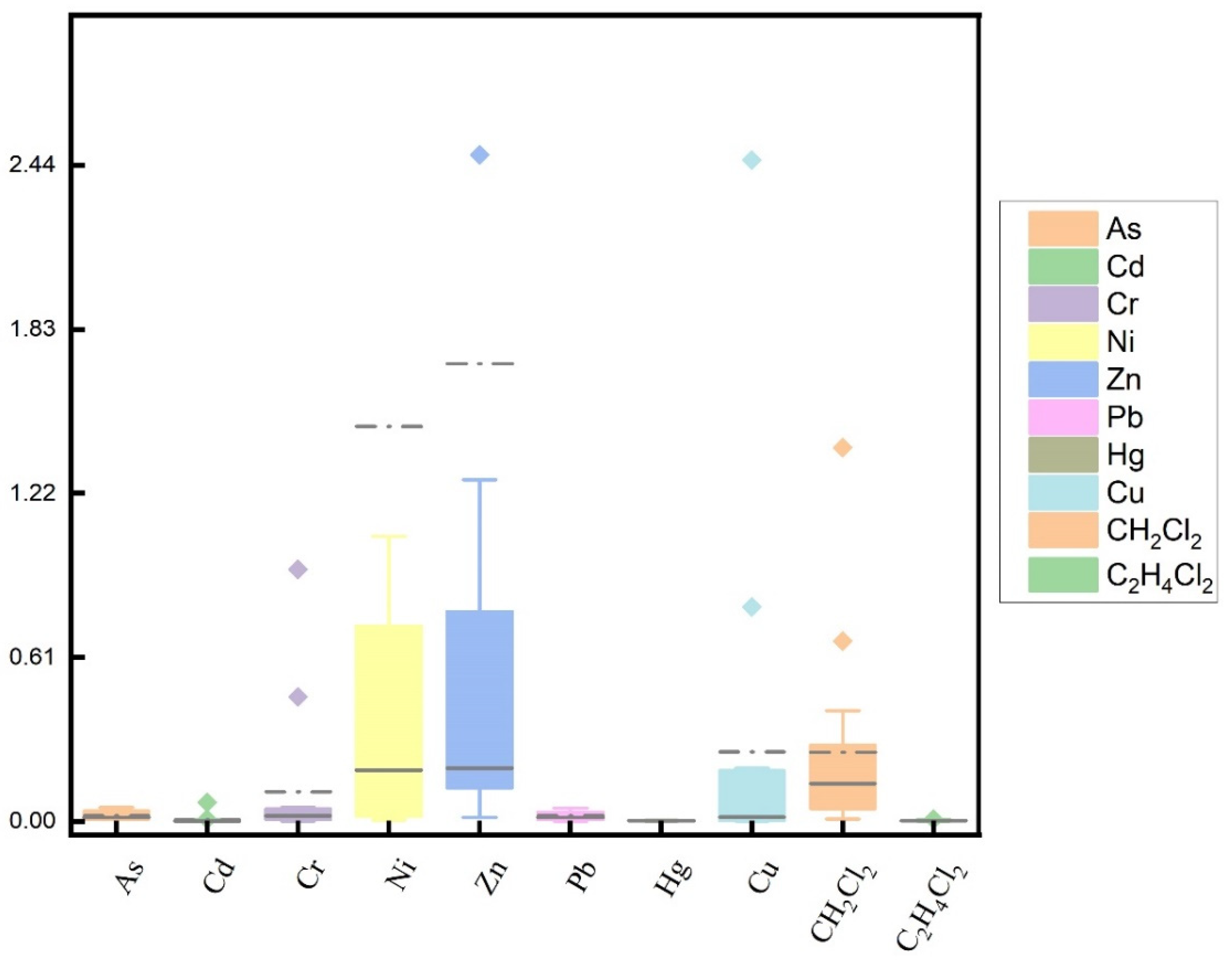
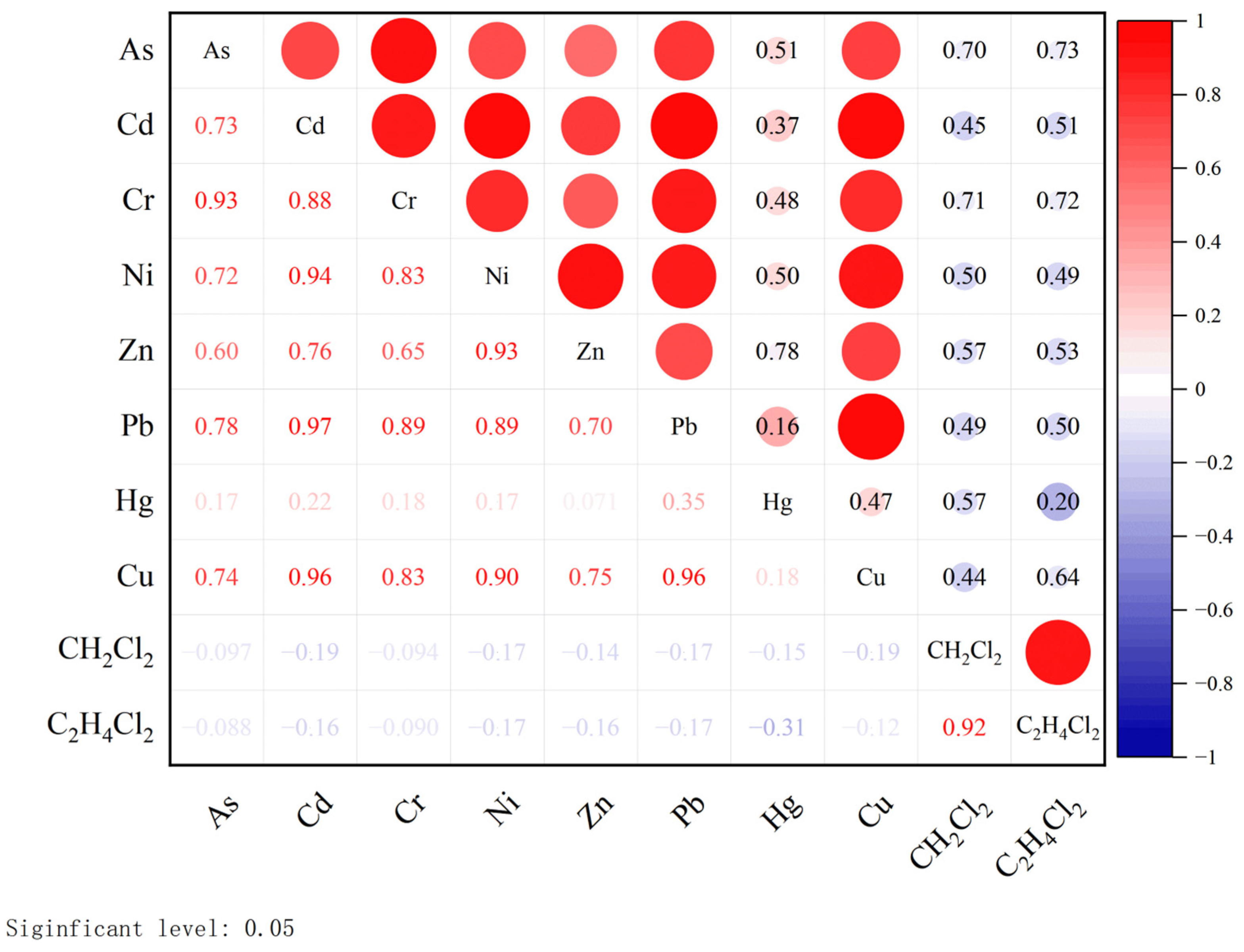
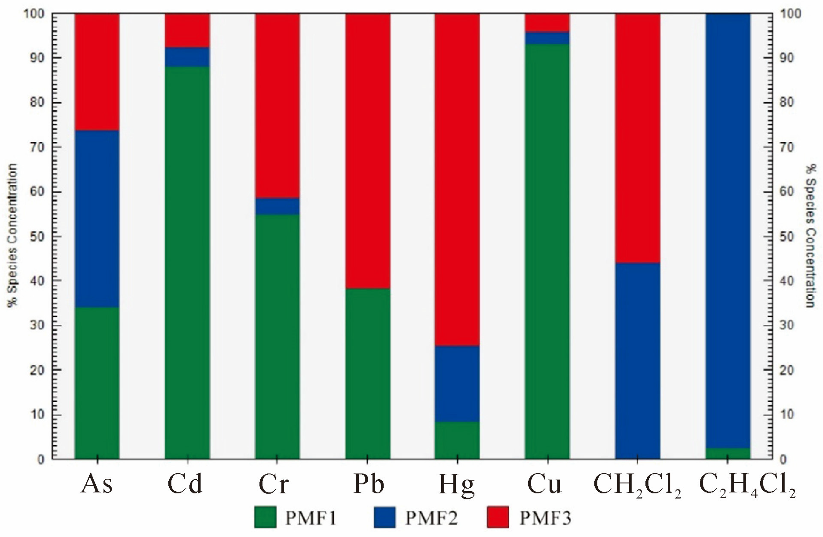
PTEs in groundwater mainly harm human health through oral intake (including direct drinking water and indirect drinking water) and skin contact (including bathing and swimming). These two methods account for more than 90% of the pollutants ingested in or in contact with the human body. PTEs in groundwater in the study area can be divided into chemical carcinogenic elements (As, Cd, Cr, CH
2Cl
2 and C
2H
4Cl
2) and chemical non-carcinogenic elements (Cu, Zn, Ni, Hg and Pb). Their risk characterization is mainly carried out in two aspects, namely non-carcinogenic risk assessment and carcinogenic risk assessment [
32].
Recipients exposed to groundwater in and around industrial areas can be divided into adults and children. The US Environmental Protection Agency (USEPA) has developed a human health risk assessment model. Based on this model, different calculation methods are used to calculate the health risks caused by oral intake and skin contact [
32]. The groundwater health risks in China are mostly based on foreign models and parameters. The actual evaluation results will be affected by uncertainties such as system models, scenarios and human activities. Therefore, the exposure parameters of Shandong Province are used as much as possible in the specific calculation process to make the research results more in line with the actual situation of local people.
- (1)
Risk exposure through oral intake route: ADDi, mg (kg × d)−1
In the formula,
cw is the pollutant concentration, mg × L
−1;
IR is drinking water intake, L × d
−1;
EF is drinking water exposure frequency, d × a
−1;
ED is the exposure period of drinking water, a;
BW is the average body weight of the population in Shandong Province (the two groups are divided into adults and children), kg;
AT is exposure time (non-carcinogenic exposure time and carcinogenic exposure time), d. Reference values of model parameters are in
Table 3.
- (2)
Risk exposure of skin contact pathway, ADDd, mg (kg × d)−1
In the formula,
cw is the pollutant concentration, mg × L
−1;
SA is the skin contact surface area, cm
2;
PC is skin permeation constant, cm × h
−1;
ET is the exposure time, h × d
−1;
EF is the frequency of skin contact exposure, d × a
−1;
ED is the duration of skin contact exposure, a;
CF is the volume conversion factor, L × cm
−3. The reference values and units of model parameters are shown in
Table 3.
- (3)
Risk characterization
The PTEs detected in the samples were divided into two categories, non-carcinogenic substances and carcinogenic substances, and their health risks are calculated according to Equations (7) and (8), respectively [
33]. The values of
RfDi and
SFi are shown in
Table 4.
In the formula, is the lifetime excess carcinogenic risk of carcinogenic pollutant i to the population for 70 years, which is dimensionless, LADDi is the daily average exposure dose of threshold chemical pollutants, mg (kg × d)−1, and the calculation method is the same as ADD.
Assuming that PTEs in water have a cumulative relationship with human health risks, the health risk R
T caused by a single element to two groups of people can be expressed as in Equation (9), and the total health risk HI caused by all elements in two ways to two groups of people can be expressed as in Equation (10).
In the formula, is the lifetime risk of health hazards caused by non-carcinogenic pollutants; ADDi is the average daily exposure dose of threshold chemical pollutants, mg (kg × d)−1; RfDi is the reference dose for a certain exposure pathway of chemical pollutants, mg (kg × d)−1; 10−6 is the acceptable risk level of the hypothesis corresponding to RfD.


